
Mirador des Balconet o del Pujador des Frares: Coastal Views and Rocky Cove
.jpg)
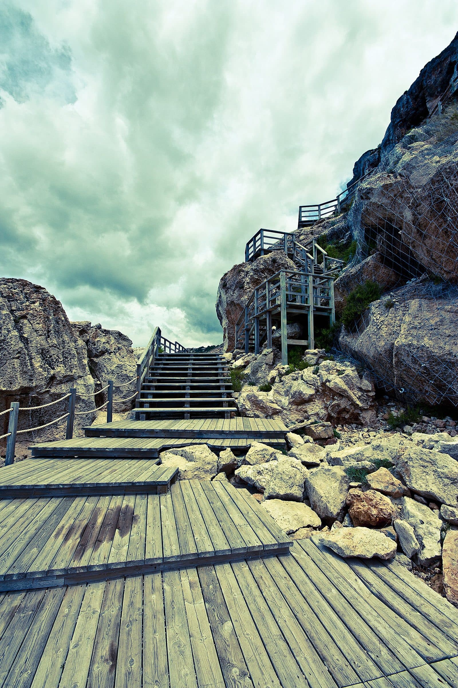
Mirador des Balconet o del Pujador des Frares reveals a side of Mallorca that has little in common with the long sandy beaches of the south. Near Bellavista, the rocky coast drops into the Mediterranean. From the viewing platform, the vista stretches across cliffs and open water; below lies a small rocky cove reached by wooden stairs and walkways.
This change of perspective is precisely what makes the place so interesting. At the top, there is time to enjoy the coastal panorama, take a break on the benches, or have a picnic. Those who descend farther experience the coast at the level of the rock slabs and reach a small jetty by the water. This is not a classic beach day: there is no sand, and the ground is rocky.
The viewpoint therefore suits visitors who want to combine a short coastal excursion with some physical activity. Photographers will find subjects along the cliffs, those seeking peace will find somewhere to sit, and swimmers can enjoy direct access to the clear sea on calm days. A brief panoramic stop requires little time; with the descent, a picnic, or a swim, it can easily become a longer stay.
Mirador is particularly well known as a sunset spot. At that time, the vastness of the sea becomes even more impressive. In midsummer, however, the atmosphere is not necessarily secluded: while the place is considered peaceful outside the high season, it can become noticeably busier during the summer months.
History and significance
The older name behind today’s viewpoint refers to the cultural landscape of Marina de Llucmajor. Possessió Cas Frares stood in this coastal part of the municipality.
Es Canyar
In the 15th century, the Cas Frares estate was still called Es Canyar. The platform, seating, and wooden descent shape the visitor experience.
The Charterhouse of Valldemossa
Records from 1484 state that Es Canyar paid annual interest of 130 pounds to the monastery of the Charterhouse of Valldemossa. Payment was due on the feast of Archangel Michael. This specific note connects the southern coastal landscape with the Charterhouse of Valldemossa.
The historical reference does not explain how today’s viewpoint complex came into being, but it does clarify the origin of the names associated with its location. This gives the visit another layer: before the view of the open sea is a place name recalling an old estate and its obligations to a monastery. Here, history is found less in walls than in the words still used to describe this stretch of coast.
What to see
The experience does not begin only at a single viewing edge. The road, platform, wooden stairs, and rocky cove form a short sequence in which the view of the coast repeatedly changes. At the top, the panorama dominates. During the descent, the rock walls draw closer, while at the bottom attention shifts to the water, rock slabs, and entry point into the sea.
The viewing platform
The platform provides an expansive view across the cliffs near Llucmajor and the Mediterranean. From here, the coastline does not resemble a bathing cove but a rugged boundary of rock and water. Depending on the light, the sea displays different shades of blue and turquoise; in calm weather, the clear water allows you to see below the surface.
Several seating areas make Mirador more than a photo stop. You can take in the panorama while seated, and the benches are suitable for a break or a picnic brought with you. Visitors who do not want to descend all the way to the sea can already experience the essential character of the place at this level. Its appeal lies in the open coastal perspective, not in a building, exhibition, or elaborately designed complex.
For photographs, it is worth aiming at more than just the horizon straight ahead. A more striking composition is created where part of the rocky coast frames the view of the sea. Late in the day, the warmer light transforms the surfaces of the cliffs and water. Because Mirador is known as a sunset spot, however, you should expect other visitors at that time.
The wooden stairs
A long network of wooden stairs and walkways leads down from the upper level. It is not merely an access route but a distinctive part of the experience: with every section, your eye level drops in relation to the coast while the rocks occupy more of your field of view. The path opens up the terrain without turning it into a level beachfront promenade.
The return journey requires more effort than the descent. The climb from the water to the parking area takes approximately ten minutes. Although that sounds brief, the combination of stairs, gradient, and summer heat should not be underestimated. Those who only want to enjoy the view do not have to complete the entire descent.
The rock slabs
At the lower end, large rock slabs take the place of a beach. When conditions are calm, you can sit, sunbathe, or have a picnic here. The area feels more natural and rugged than a developed bathing zone. Towels lie directly on the stone, and there is no soft sandy surface on the way to the water.
This rocky landscape is an essential part of the place’s character. Anyone expecting a sandy cala will not find one at Mirador. Those looking for a spot directly beside the cliffs and willing to forgo comfort, however, can experience a different closeness to the sea below than from the platform.
The small jetty
A small jetty provides direct access to the water. On calm days, the rocky cove is used for swimming and snorkeling. The clear water makes it easier to see fish below the surface. This opportunity for observation makes the lower area particularly interesting for snorkelers.
The entry remains rocky, however, and there is no sandy beach. Waves, wind, and wet surfaces can immediately change the situation. You should enter the sea only if access and exit appear safe and your swimming ability is appropriate for the conditions. Anyone in doubt should remain on the rock slabs or enjoy the view from above.
Visiting Mirador
Even the steep, winding approach road sets the tone for a place away from the major coastal roads. From the parking area, the final section leads to the viewpoint; the platform is approximately 150 meters away. Once there, you can decide whether to enjoy a peaceful panoramic break or make the wooden stairs down to the rocky cove part of the excursion.
A short scenic stop
For visitors who mainly want to take photographs and sit on a bench overlooking the sea, Mirador is a compact stop. The platform is close to the parking area, so no long hike is necessary. Even so, it is worth resisting the urge to leave immediately: the different views along the cliffs and down toward the rocky cove only reveal themselves when you look around slowly.
A fixed visit duration would make little sense. Without the descent, the visit can be brief; a picnic, the walk to the water, or a snorkeling break will extend it considerably. Planning should also account for the return journey up the stairs, which takes approximately ten minutes from the sea to the parking area.
Morning and the off-season
Outside the main summer season, Mirador is described as peaceful and rarely visited. At those times, the view and the sound of the water take precedence over finding a free seat or a suitable spot on the rocks.
Anyone seeking solitude should avoid midsummer if possible. At that time, both the view and access to the water attract visitors. The parking area, stairs, and limited rocky surfaces may consequently be much busier.
Sunset
In the evening, Mirador becomes a gathering place for people who want to watch the sunset over the sea. The benches and unobstructed horizon make the location particularly suitable. The warm light emphasizes the contours of the cliffs while the colors on the water’s surface change.
Precisely because this time of day is popular, it is not automatically the quietest. After sunset, the return journey takes place in rapidly fading light; anyone descending to the rocks should not wait until darkness to set off again.
Getting there and parking
From the main road, the route enters the coastal landscape near Bellavista and eventually follows a steep, winding access road toward the viewpoint. A standard rental car can manage the route, but the hairpin bends require attention. Driving slowly is particularly advisable where oncoming traffic, blind corners, or limited road space coincide.
From Palma Airport
From Palma Airport, the route follows Ma-6014 to Bellavista. The road distance is 14 kilometers, and the journey takes around 32 minutes. These figures explicitly apply only as far as Bellavista, not to the viewing platform itself. The local access road and steep bends must be added for the final section.
The comparatively short distance makes Mirador a possible coastal stop after arrival or before the return flight. Even so, a generous time buffer is advisable: the final bends cannot be driven as quickly as a main road.
From central Palma
From central Palma, the route initially follows Ma-19 and then Ma-6014 to Bellavista. The road distance to that point is 20 kilometers, and the journey takes around 43 minutes. Here too, the measured route ends in Bellavista. The onward drive to Mirador follows the local road network and steep coastal access road.
Anyone traveling from Palma should not plan the excursion solely around the basic driving time. Sunset is a popular time to visit.
Parking and the final walk
A parking area is located near the beginning of the wooden walkways. From there, it is approximately 150 meters to the viewpoint. The car can therefore be parked relatively close to Mirador; this should be clearly distinguished from the path down to the sea, which follows the longer network of stairs.
The location can become significantly busier in midsummer.
Getting there by bus
The stops Badia Blava 1, Badia Blava 2, Badia Gran 1, and Mirador de sa Torre 2 are located in the wider coastal area. However, they are not directly beside the platform. The final sections to Mirador, particularly the steep access road, must be considered separately when planning a bus journey. It is therefore advisable to check the current route and a suitable walking route before traveling; the viewpoint is not designed for a short, direct bus drop-off.
Bus lines to Mirador des Balconet o del Pujador des Frares at a glance
| Line | Route | Departures/day | First | Last |
|---|---|---|---|---|
| 504 | Tolleric - Palma | 649 | 05:57 | 23:58 |
| 505 | Cala Pi - Tolleric | 43 | 07:02 | 20:47 |
From the official GTFS feeds (TIB/SFM), no real-time data. The figures cover all stops in the town; weekend and holiday services differ — check with the operator before travelling.
Getting there by bus
Badia Blava 2 (31113) · 0.6 km as the crow flies
- 504Tolleric - Palma · Daily
Badia Blava 1 (31114) · 0.6 km as the crow flies
- 504Tolleric - Palma · Daily
Mirador de sa Torre 2 (31117) · 0.9 km as the crow flies
- 504Tolleric - Palma · Daily
Badia Gran 1 (31112) · 0.9 km as the crow flies
- 504Tolleric - Palma · Daily
Mirador de sa Torre 1 (31116) · 0.9 km as the crow flies
- 504Tolleric - Palma · Daily
Badia Gran 2 (31111) · 0.9 km as the crow flies
- 504Tolleric - Palma · Daily
Santa Maria 2 (31118) · 1.2 km as the crow flies
- 504Tolleric - Palma · Daily
Santa Maria 1 (31083) · 1.3 km as the crow flies
- 504Tolleric - Palma · Daily
Sa Torre 1 (31079) · 1.4 km as the crow flies
- 504Tolleric - Palma · Daily
Sa Torre 2 (31115) · 1.4 km as the crow flies
- 504Tolleric - Palma · Daily
Tolleric 2 (31109) · 1.6 km as the crow flies
- 504Tolleric - Palma · Daily
- 505Cala Pi - Tolleric · Daily
Tolleric 1 (31110) · 1.7 km as the crow flies
- 504Tolleric - Palma · Daily
- 505Cala Pi - Tolleric · Daily
Timetable data: official GTFS feeds (TIB/EMT), no real-time — check with the operator before travelling.
Nearby places
Bellavista belongs to the inhabited coastal zone south of Palma where residential areas, rocky coves, and viewpoints follow one another. Mirador showcases the more natural side of this stretch: a steep coast with a direct view of the sea.
Bellavista
As the reference point for the travel directions, Bellavista is particularly important for orientation. From here, the local road network continues toward the coast. Visitors to Mirador should therefore distinguish between the destination “Bellavista” in general route planning and the actual viewpoint. The measured driving times from the airport and Palma end in the town; the final bends follow afterward.
Badia Blava and Badia Gran
Badia Blava and Badia Gran lie in the same southern coastal area and can easily be incorporated into a drive through the region. Both names also appear when planning travel by public transport because stops are located there. Anyone wishing to combine Mirador with other impressions of the coast will find suitable reference points here without having to travel to a completely different part of the island.
Such a combination is particularly sensible if the scenic stop itself is brief. Anyone descending to the rocky cove, swimming, or staying until sunset should avoid overloading the day with too many additional destinations. The strength of Mirador lies precisely in spending time looking at the sea rather than merely taking a photograph and immediately driving on.
Caló de ses Lleonardes and Cala Blava
Other names that arise when exploring this stretch of coast include Caló de ses Lleonardes and Cala Blava.
For planning purposes, combining one of these destinations with Mirador is sufficient. Anyone wishing to visit Pujador des Frares late in the day should not risk missing the sunset by scheduling an overly tight circular drive.
The place it belongs to
Bellavista in the place guidePractical information for your visit
Mirador can be reached without a long hike, but the proximity of the parking area should not be confused with a fully comfortable bathing facility. The platform, stairs, and rock slabs present different challenges. At the site, it helps to approach the excursion in stages and descend only as far as the path, weather, and your own fitness make reasonable.
Shoes for stairs and rocks
The wooden stairs provide a defined route through the terrain. At the bottom, there is no sand, only hard rock.
Anyone wishing to swim can enter the water via the small jetty. The rocky character of the cove remains unchanged.
Sun, shade, and water
The climb from the sea takes approximately ten minutes. All rubbish should be carried back up; the rocky cove depends on its natural, largely undeveloped appearance.
Visiting with children
The parking area is approximately 150 meters from the upper platform. There is seating for a break and views of the cliffs and the Mediterranean.
Wooden stairs and walkways lead from the platform down to the rock slabs and the small jetty by the water. The lower cove has no sandy beach; the ground is rocky.
Swimming and snorkeling
On calm days, the clear water is inviting for swimming and snorkeling. Fish can be observed below the surface, and the small jetty provides a defined access point. There is no sandy beach; the ground is rocky.
Before entering, check the wind, waves, and whether a safe return to the jetty is possible. When the sea is rough, Mirador remains a worthwhile viewpoint even without a swim.
Local insider tips
Choose the off-season for peace
Mirador is known for sunsets and can be busy at that time. Those mainly seeking peace should visit outside the main summer season, when the platform and wooden walkways offer a more relaxed experience.
Use the cliffs as a frame
For a stronger coastal photograph, do not aim only at the unobstructed horizon: the rocky flanks can be included in the image from the platform. This makes the distinctive character of Mirador more visible than in a photograph showing only the sea.
Plan for the return climb
The descent via the wooden stairs feels easier than the journey back. The climb from the sea to the parking area takes approximately ten minutes; on hot days, make sure you have enough water and energy left for it.
Snorkel only in calm conditions
When the sea is calm, the clear water by the small jetty is well suited to snorkeling and observing fish. When there are waves, it is better to remain on the rock slabs or at Mirador above, as there is no sandy beach.
The bus stop is not Mirador
Badia Blava, Badia Gran, and Mirador de sa Torre have stops in the coastal area, but none is directly beside the platform. Before traveling by bus, check the current connection and the remaining walking section separately.