
Castell d'Alaró – Rocky Fortress, Hike and Views
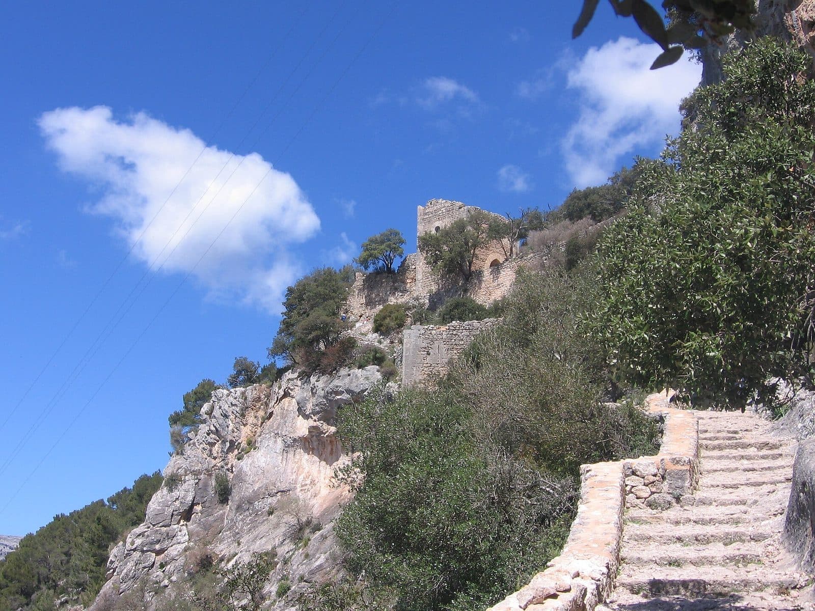

The journey itself is part of the experience. Castell d'Alaró stands on the rugged Puig d'Alaró. To reach the ruins, visitors follow old paths through olive groves and pine woods before completing a paved ascent on foot. Only at the gate does it become clear why this rock served for centuries as a natural lookout and a fortress that was difficult to conquer.
There is no fully furnished castle waiting at the top. Instead, visitors find an extensive rocky fortress with remains of walls, towers, cisterns, a small pilgrimage church and a hostel. That is precisely what makes it so appealing: the ruins do not explain their history in enclosed exhibition rooms, but through their location. Steep cliffs provide part of the defence, while the only readily usable approach could be controlled.
Castell d'Alaró is worthwhile for hikers, history enthusiasts and anyone looking for a destination with an impressive island panorama. The ascent is more than simply the route to an attraction. It makes the strategic importance of the site physically tangible and leads step by step from the cultivated surroundings into a rugged mountain landscape.
The castle is not suitable for a fleeting stop, however. The final section must be completed on foot, and even beyond the gate there is still plenty to discover. Those who allow time for the walls, towers, chapel and views will better understand why the Castell remains one of Mallorca's most symbolic historic sites.
History and Significance
The earliest reliable accounts describe not a palace, but resistance. Arabic chronicles mention the fortification in the 10. century as Hisn Alarum, the “fortress of the Christians.” During the Muslim conquest of Mallorca, the stronghold is said to have held out for more than eight years. This episode alone shows what its strength was based on: less a continuous ring of walls than a rock whose vertical sides restricted access to a few controllable points.
Archaeological traces in the surrounding area reach further back. Evidence of Talayotic settlement as well as Roman and Byzantine presence suggests that the Puig served as a lookout and refuge long before the medieval Castell. This does not provide a continuously reconstructable building history. What is certain, however, is that very different rulers recognised and used the exceptional location.
Hisn Alarum
The mention in the Arabic chronicles marks the first clear appearance of the site in recorded history. The name Hisn Alarum referred to a fortified height from which defenders could observe the surrounding valleys and approaches. The terrain itself was the most important part of the fortification: attackers had to approach along a restricted ascent, while the rocky sides offered scarcely any alternative access.
After the Christian conquest of Mallorca, the castle remained militarily important. The fortifications continued to be used and expanded. They protected not only the summit but also served as a refuge and as a means of controlling the land on the edge of the Serra de Tramuntana. Together with Castell del Rei and Castell de Santueri, the Castell is one of the three rocky fortresses on Mallorca whose natural setting forms an essential part of their defensive strength.
Cabrit and Bassa
The best-known episode took place in 1285. When Alfons III of Aragón sought to bring Mallorca under his rule, Guillem Cabrit and Guillem Bassa resisted at Castell d'Alaró. Their resistance ended in defeat and a brutal execution. In Mallorca's collective memory, both became symbols of loyalty to the Kingdom of Mallorca and popular heroes.
Legends grew around their fate and remain associated with the site today. One tradition even connects the reddish evening light on Puig d'Alaró with the blood shed during the medieval battles. Historical events and popular interpretation lie close together here.
From Military Site to Pilgrimage Destination
Over time, the Castell lost its military role. The Nostra Senyora del Refugi oratory was built above the old fortifications in 1622. From the 17. century onward, the summit increasingly developed into a place of worship and pilgrimage. After the military occupation ended in 1741, religious use ultimately shaped the site more strongly than defence.
In 1931, Castell d'Alaró was declared a Spanish cultural monument. Today it is simultaneously a ruin, hiking destination and place of remembrance. Its significance lies not in lavish interiors, but in the connection between landscape and history: the ascent, controlled gateway and steep rocky edges still explain why the castle was considered almost impregnable for so long.
What to See
The defining moment comes at the end of the paved trail. The path narrows, climbs between rock and wall and leads towards the historic castle gate. Here, the site reveals itself not as a symmetrically designed palace but as a defensive system adapted to the shape of the summit. Beyond the entrance, the individual remains are scattered across the plateau.
Torre de l'Homenatge and Castle Gate
Torre de l'Homenatge guarded the main entrance. The remains of the tower and the preserved gate form the most impressive medieval section of the site. Visitors approaching from below follow exactly the route that could once be controlled most easily. The walls do not stand freely on a plain, but connect with the rock and force the path through a narrow area.
The tower is often described as the main tower or keep. Today, however, visitors should not expect a comfortably furnished stronghold. Its appeal lies in the combination of limestone masonry, uneven ground and the steep ascent immediately before the gate. Nowhere else is the defensive logic of the Castell so clear.
Fortress Wall and Five Towers
Large sections and traces of five towers survive from the former fortress wall. Some parts appear less impressive close up than they do from the valley. Only when walking along the edges does it become clear how the walls and natural drops combined to create a position that was difficult to attack.
The ruins require some imagination. There is no fully preserved sequence of halls, courtyards and battlements. Instead, stretches of wall, tower remains and terrain edges mark the former extent of the complex. For that reason, it is worth not heading directly to the chapel after passing through the gate, but taking in the different viewpoints and tracing the course of the fortifications across the terrain.
Torre de la Cova
Torre de la Cova stands in the southern part of the complex. Alongside the entrance, this tower is one of the most distinctive remains. Below it lies the Sant Antoni cave, which can be reached on foot.
This area demonstrates particularly clearly how closely architecture and natural topography are connected. The tower stands on a steep rocky edge. Visitors approaching it should take the uneven ground seriously. The views are extensive.
The Cisterns
Five cisterns supplied water within the castle. Such reservoirs were vital for a garrison on an isolated summit: a fortress could resist only as long as its water and provisions lasted. The cisterns are thought to be possibly of Arabic origin, although their exact history has not been fully established.
They are among the details that many visitors initially walk past. Yet they reveal at least as much about life on the mountain as the towers do. Walls kept attackers out; the water reservoirs made extended stays and sieges possible in the first place. Anyone examining the depressions and enclosed storage chambers is therefore seeing not a minor feature, but a core part of the medieval infrastructure.
Nostra Senyora del Refugi
The Nostra Senyora del Refugi oratory stands above the military ruins. The small pilgrimage church was built in 1622 and shifted the focus of the site from defence to worship. Its simple exterior suits the secluded setting. After the rocky ascent, the chapel feels less like a prestigious church than a sheltered resting place on the mountain.
Beside the chapel is a Hospedería, or mountain refuge. As a result, the summit area is not merely an archaeological ruin but remains a place used by visitors and pilgrims today.
The Panorama
The view opens across two very different landscapes. To the south lie Alaró and the broad plain of the island's interior. To the north rise the mountain ranges of the Serra de Tramuntana. This contrast makes the Puig an especially useful landmark: cultivated inland terrain spreads out on one side, while rocks and mountain ridges rise in layers on the other.
The view is not merely an extra feature of the castle. It explains its location. From up here, movement in the valleys could be detected early, while the summit itself was accessible only by a restricted approach. In clear weather, it becomes easy to understand why the rock served in turn as a lookout, refuge, fortress and finally as a destination for pilgrims and hikers.
Visiting Castell d'Alaró
A visit begins long before the castle gate. The route described by the municipality starts in the centre of Alaró and initially leads towards Carretera d'Orient. A marked turnoff points towards the Castell. Asphalt and concrete sections give way to old paths, while shortcuts pass through olive groves and pine woods. Vehicles must be left behind in the upper area because the final section must always be completed on foot.
The Ascent from Alaró
For the signposted route, the municipality gives a distance of 4.2 kilometres and a walking time of 3 hours and 45 minutes. It is classified as easy to moderate. This rating should not be confused with a level stroll: the route gains height steadily, includes paved sections and can feel considerably more strenuous in warm weather.
Along the way, the older path crosses the more modern access road several times. Signposts lead hikers back to the historic route. This adds variety to the ascent but requires attention at the junctions. The final metres to the gate are the atmospheric highlight: steps and paving climb directly beneath the old walls until the entrance opens between rock and tower.
The Shorter Route via Es Verger
Visitors who drive part of the way often use the area around Es Verger as the starting point for the walk. The access road is narrow and winding and should not be mistaken for a comfortable mountain road. Oncoming traffic and blind hairpin bends can take more time than the short distance might suggest.
Even from there, the ascent should be taken seriously. It is not possible to drive directly to the Castell. Before setting out, visitors should check how far the access road is currently passable and where parking is permitted. The historic paved sections and final climb remain part of the visit regardless of the chosen starting point.
Time on the Castle Plateau
The excursion is not over after passing through the gate. Several stops lie between Torre de l'Homenatge, the wall remains, Torre de la Cova, the cisterns, chapel and viewpoints. Anyone who walks only to the first panorama and immediately turns back will miss the site's transformation from a military ruin into a place of pilgrimage.
For the excursion as a whole, the official walking time for the route from Alaró provides a reliable guide. Taking photographs, having a longer rest and visiting the chapel area will extend the trip accordingly.
Time of Day and Season
Spring and autumn are considered especially suitable for hiking because temperatures are generally more pleasant than in the summer heat. An early start is recommended during the warmer season. Although parts of the route pass through olive groves and pine woods with shady resting places, the open summit plateau and upper ascent are exposed to the sun.
The Castell is a well-known hiking destination. Visitors seeking peace and quiet should start in the morning whenever possible and plan not only the ascent but also a safe return in daylight. Opening hours and admission details are not reliably recorded and may change. Both should therefore be checked immediately before the excursion.
Getting There and Parking
The navigation information on this page initially leads to Habitat. From Palma Airport, Habitat is 27 road kilometres away; the drive takes around 43 minutes via Ma-30, Ma-13 and Ma-13A. From the centre of Palma, the road distance to Habitat is 24 kilometres. Allow around 48 minutes via Ma-13 and Ma-13A.
These figures expressly apply only as far as Habitat, not to the castle gate or summit. The local journey then continues towards Alaró and Carretera d'Orient. From there, signs point to the castle path. Depending on the chosen starting point, the journey continues along a narrow mountain access road or directly on foot.
The Mountain Access Road
The access road towards Es Verger winds uphill through tight bends. Some sections are asphalted or concreted, while others are rougher. It requires slow driving and consideration when meeting oncoming traffic. A small car is easier to handle on a road like this than a wide vehicle, but even then visitors should not try to drive as far uphill as possible.
The key point remains: Castell d'Alaró cannot be reached by car all the way to the entrance. The final section follows a paved or rocky path and must be completed on foot. Driving shortens the hike; it does not replace it.
Parking
The area around Es Verger is commonly used as a starting point. Whether the access road is usable should be checked locally. Those who want to walk the complete municipal route should instead start in Alaró and avoid the more demanding mountain drive.
Arriving Without a Car
No bus stop is recorded in the immediate vicinity of the Castell. A journey by public transport therefore does not end directly at the hiking route or ruins. Anyone arriving without a car must include the longer walk from the town and the later return journey in their planning.
Particularly in the afternoon, it is important to check not only the connection to Alaró but also to allow sufficient time for the descent. The paved final section requires just as much attention when descending as it does on the way up.
Nearby Places
Habitat is the reference point for the stated road journey, while Alaró provides the classic access route to the castle. The town lies between the island's interior and the first distinctive heights of the Serra de Tramuntana. From its streets, Puig d'Alaró is widely visible with its striking, steep-sided shape.
Alaró
Alaró is a suitable starting point for those who want to experience the route to the castle as a complete hike. The municipal route begins in the town centre and follows signs towards Carretera d'Orient. This creates a clear transition from the inhabited town through an old cultivated landscape and up to the medieval rocky fortress.
After the descent, Alaró offers an opportunity for a break without adding another major attraction to the day. Anyone walking the entire route should in any case treat the combination as an excursion in its own right rather than a short stop between several widely separated sights.
Es Verger
Finca Es Verger lies on the well-known ascent route and serves as a landmark for many hikers. From here, the route to the castle continues on foot. Olive groves and pine woods accompany parts of the trail before the terrain becomes rockier and the historic paved path more distinct.
Es Verger can be combined with a meal or refreshment stop, but current closing days and serving times should be checked independently of the information for the Castell. For planning purposes, the most important point is not to confuse the location with the destination: the actual castle ascent still remains after reaching the finca.
Orient
An alternative hiking route leads from Orient to the Castell. It turns the visit into a longer mountain hike and approaches the castle from a different direction. The route is described as scenic but requires careful planning for both the outward and return journeys.
Hikers ascending from Orient also pass through the area around Es Verger. A refreshment stop will not necessarily come at the end of the hike; another ascent may still follow afterwards. For a first visit, the signposted route from Alaró is generally easier to follow.
The place it belongs to
Habitat in the place guidePractical Information for Your Visit
Loose stones, old paving and uneven steps define the upper route. Sturdy footwear with good grip is therefore more important than light city shoes. This becomes especially clear on the descent: on worn stone, a single careless step can cause a slip.
Water, Sun and Shade
Carry sufficient drinking water in your backpack. The historic cisterns are part of the castle complex but are not a guaranteed source of drinking water for visitors. A hat is particularly useful during the warmer months. Shady places can be found along the route in the olive groves and pine woods, but there is less shelter on the plateau.
The summer heat should not be underestimated. An early start reduces the strain and leaves more time for breaks.
Visiting with Children
For children experienced in hiking, the route can be exciting: a real castle gate, old towers, cisterns and a history filled with sieges give the ascent a clear goal. Sure-footedness, suitable footwear and enough stamina for both the outward and return journey are essential.
Close supervision is necessary near the rocky edges and ruins. The Castell is not a fully secured visitor attraction. Uneven terrain, historic walls and steep drops are part of the site's character.
What Not to Expect
The Castell does not offer a sequence of restored state rooms or a conventional palace tour. Its most important remains are the gate, towers, wall sections, cisterns and later chapel. Anyone expecting a completely reconstructed fortress will misinterpret the site.
Nor are the ruins an easily accessible viewpoint. The panorama must be reached on foot, and the length of the visit depends substantially on the starting point. Yet this combination of route, terrain and architecture is the key to Castell d'Alaró: only during the ascent does it become clear why the castle was able to resist for so long.
Local insider tips
Look Back at the Gate
Directly below Torre de l'Homenatge, the defensive logic is easiest to understand: the paved trail narrows between rock and wall. Looking back reveals how easily the only practical approach could be controlled.
Do Not Miss the Cisterns
The five cisterns appear inconspicuous beside the towers and panorama. Yet they explain how a garrison could hold out on the isolated rock. Without stored water, even the strongest wall would have been of little value during a siege.
Compare Two Landscapes
From the plateau, deliberately change the direction of your view: Alaró and the flat island interior lie to the south, while the mountains of the Serra de Tramuntana rise to the north. This broad overview explains exactly why the castle rock was chosen.
Start in Alaró Instead of Driving Uphill
Anyone wishing to avoid the narrow, winding access road to Es Verger can start in the centre of Alaró. The municipal route is signposted and connects the town with the historic paved castle path through olive groves and pine woods.
Do Not Turn Back at the Castle Gate
Beyond the medieval walls, the visit continues to the Nostra Senyora del Refugi chapel and the Hospedería. Only there does the transformation from a military fortress into a place of pilgrimage and remembrance become clear.