
Castell de Alaró – Rock Fortress Above Central Mallorca
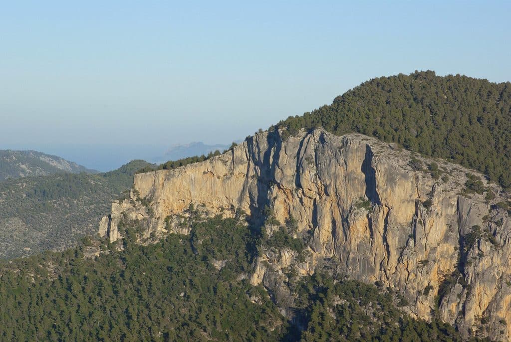

The journey itself is part of the story: Castell de Alaró does not appear at the end of an easy access road, but only after a climb through olive groves, pines, and rocky terrain. The ruin stands on Puig d’Alaró, a striking flat-topped mountain above the island’s interior. Its setting makes it immediately clear why this place was considered virtually impregnable for centuries.
At the top, you will not find a fully preserved castle with furnished halls, but the remains of a rock fortress whose walls and towers are directly integrated into the terrain. The narrow approach, fortified gate, and steep mountain slopes reveal more about medieval defense than many elaborately reconstructed sites. There are also sweeping views across the plain south of the Serra de Tramuntana and into the northern mountains.
The visit is particularly rewarding for anyone who does not want to separate history from hiking. Those wishing simply to step out of the car and tour a castle, however, have come to the wrong place, as the final section must be covered on foot. This approach is precisely what makes the experience so appealing: with every bend, it becomes clearer why attackers had to overcome not only walls on this mountain, but above all the topography.
History and significance
The fortress in 902
The oldest reliable written record dates to 902. At that time, Mallorca came under Muslim rule, and the mountain fortress played a military role because of its hard-to-reach location. Puig d’Alaró offered far more than a high observation point: its almost vertical slopes made an attack impossible in many places. Above all, defenders could control the only practical approach, which still determines the route of the ascent today.
The Castell is therefore one of Mallorca’s rock fortresses where mountain and structure can barely be separated. The defenders did not need to surround the entire summit with equally strong walls because the rock itself performed much of that function. This combination of natural barrier and fortified entrance shaped the site’s importance through different periods of rule.
Conquest and retreat in the Middle Ages
When Jaume I. conquered Mallorca in 1229, Muslim groups sought refuge in the mountains. Castell d’Alaró also served as a place of retreat and was therefore not merely an observation post, but also a place where Muslim groups sought protection.
A legend still told today is associated with Jaume I.’s ascent. Near the stairs to the castle entrance, an imprint resembling a horse’s hoof is said to be visible in a stone. According to tradition, it was left by the king’s horse during the advance against the defenders. The hollow does not qualify as historical evidence, but as part of local memory it shows how closely the story of the conquest became linked to the actual route up to the castle.
Cabrit and Bassa
The best-known episode took place in 1285. During the conflicts surrounding the Kingdom of Mallorca, the defenders Cabrit and Bassa resisted the forces of the Aragonese king Alfons III. Their resistance turned both men into folk heroes in Mallorcan tradition. The Castell thus became more than an abandoned military structure: it remained in cultural memory as a symbol of resistance.
The fortification walls visible today, with their five towers, date mainly from the 15. century. They are therefore not unchanged parts of the earliest complex mentioned in 902, but belong to a later building phase. This sequence of periods is important on site: the ruin does not tell the story of a single self-contained era, but reveals the location of a fortress that was used, altered, and refortified over centuries. Since 1931, the Castell has been protected as a Spanish cultural heritage site.
What to see
The fortified entrance
The defining moment comes at the upper end of the path. Instead of a broad castle frontage, a controlled, fortified entrance appears, securing the mountain’s natural weak point. Here, the defensive logic of the complex becomes particularly clear: anyone wishing to reach the Castell had to climb through exactly this passage, where the garrison could concentrate its attention.
Steps and irregular paving reinforce the impression of a fortress set into the rock. The stones are not a decorative forecourt, but part of a steep approach. This is also where visitors are shown the hollow said by legend to have been left by the hoof of Jaume I.’s horse. In the entrance area, it is therefore worth looking not only upward, but also at the stones along the path.
Fortification wall and five towers
No enclosed palace wings survive from the medieval complex. Instead, sections of wall and tower remains define its character. The present fortification wall with five towers is attributed to the 15. century. Together, these remains trace the line along which the accessible part of the summit was secured.
In some places, the masonry seems like an extension of the mountain. This is precisely the architectural distinction of Castell de Alaró: the fortress was not designed independently of its surroundings, but used edges, rocky terraces, and cliffs as parts of its defensive system. Where the mountainside itself was impassable, no monumental wall was required. Where access remained possible, the gate, towers, and fortifications became all the more important.
The ruins require some imagination. There is no uninterrupted sequence of rooms leading visitors through the site as in a castle museum. Instead, individual sections of wall reveal themselves one after another, while views into the valley repeatedly open up between them. Those who walk slowly around the surviving remains can better understand how closely the usable areas, defensive line, and natural rock related to one another.
The main tower and ruin areas
Among the visible remains, the area of the main tower stands out. Here too, the emphasis is not on complete reconstruction, but on the function that can still be understood: an elevated position, control of the entrance, and a connection to the surrounding walls. The surviving sections convey an impression of the fortifications’ strength without fully reproducing their former appearance.
Across the summit, the visit unfolds through open areas of ruins. This changes how the castle is perceived compared with one in a valley: behind a wall, there is not necessarily an interior; often the sky opens instead, and beyond the stones the terrain drops away steeply. Wind and changing light are more than mere scenery here. They make the fortress’s exposed position on the mountain tangible and reveal how much of the surrounding land could be surveyed.
Views from Puig d’Alaró
The view is not only a reward for the hike, but also essential to understanding the site’s history. To the south, it extends across Alaró and the plain of the island’s interior, while the ridges of the Serra de Tramuntana rise to the north. In clear conditions, it is easy to understand which movements through the valleys and across the neighboring landscapes could be observed from the fortress.
The summit of Puig d’Alaró reaches 822 meters. Because of the steep slopes, the position feels even more exposed than the elevation alone suggests. The contrast between near and distant views is particularly striking: rough wall stones and rocky edges lie directly at your feet, while beyond them the landscape opens far past the castle. A clear day is therefore more valuable for this visit than merely warm weather.
Visiting Castell de Alaró
The classic hike from Alaró
The signposted excursion begins in the center of Alaró and initially follows signs for the road toward Orient. From there, the castle path branches off. The municipal tourist information describes a route of 4,2 kilometers and classifies the difficulty as easy to moderate. This rating should not be confused with a level stroll: the route climbs steadily, and the surface changes several times.
At first, paved or concrete sections lead through rural surroundings. The path passes the areas of Son Curt and Son Penyaflor. Higher up, older sections of trail provide shortcuts between the bends, and signs lead from the modern driving track back to the historic route. Olive groves and pines accompany much of this section before the terrain becomes more open toward the Castell.
The hike via Es Verger
Those who continue driving farther into the mountain can begin the footpath in the area of Es Verger. From there, roughly three quarters of an hour is often allowed for the ascent to the ruins. The actual time required depends on pace, ground conditions, and breaks. Considerably more than the ascent time alone should therefore be planned for the outward journey, sightseeing, and return.
The final section retains paved stretches and can only be covered on foot. As a result, the castle cannot be visited casually, but remains a hiking destination even on the shorter route. Those starting from the center of Alaró turn it into an excursion lasting several hours; visitor reports suggest roughly twice the time for the full route compared with a start at Es Verger. A longer circular hike through the Orient valley takes correspondingly more time and requires more careful navigation.
Time of day and weather
On clear days, long-distance visibility is at its best. Clouds, haze, or low-lying fog can significantly limit the scenic aspect of the visit. In summer, the heat makes the ascent more strenuous, even though some sections pass through olive groves and pine stands. Starting during the cooler hours of the day is therefore more pleasant than climbing in the greatest heat.
The Castell is a well-known hiking destination, and ascending and descending groups meet at the narrow entrance and along the paved sections. Enough time should be left for the ruins themselves: a quick look from the gate underestimates the size of the complex and barely does justice to either the tower remains or the various viewpoints.
Admission is free. As no reliable visiting hours are recorded and accessibility or local regulations may change, checking current information before setting out is recommended. This is particularly important when the visit is combined with a longer hike and no alternative timing remains.
Getting there and parking
From Palma and the airport to Habitat
The recorded driving directions initially lead to Habitat, not directly to the castle gate. From Palma Airport, the road distance to Habitat is 27 kilometers. The drive takes around 43 minutes and follows the Ma-30, the Ma-13, and then the Ma-13A. From central Palma, the road distance is 24 kilometers; the route via the Ma-13 and Ma-13A takes around 48 minutes.
From Habitat or the Alaró area, the actual approach to the mountain begins. Signs lead to Carretera d’Orient and then to the turnoff toward the Castell. The final driving sections are no longer part of an ordinary cross-country route: the road climbs in tight bends, is narrow, and carries traffic in both directions. Potholes and blind sections require slow, cautious driving.
The final section to the Castell
There is no direct road access to the ruins. Although part of the ascent can be covered by car, the final section is reserved for pedestrians. Es Verger serves as a reference point for many visitors changing from driving to hiking. Whether and where parking is possible there on the day of the visit should be determined on site from the signs and current regulations.
Trying to drive as far up the mountain as possible is not necessarily the most pleasant option. On the narrow road, oncoming vehicles can make maneuvering difficult, and the road surface varies. Those who prefer hiking to driving on narrow switchbacks can start in Alaró. This makes the excursion longer, but allows the full transition from the village through the olive groves to the rock fortress to be experienced.
Public transport
No bus stop is recorded in the immediate vicinity of the attraction. Even reaching the surrounding area does not replace the ascent: the Castell is located on the mountain, and the final section must always be completed on foot. For those planning a visit without their own vehicle, the key is first to reach Alaró and then allow enough time and energy for the signposted castle path.
Navigation should be set for the starting point of the chosen hike, not just for the name of the ruins. Anyone entering only the Castell as a driving destination may otherwise be directed onto a road that is uncomfortable for their vehicle or does not reach the presumed destination. The mountain path remains part of the visit, regardless of how the journey to Habitat or Alaró is made.
Nearby places
Habitat and Alaró
The driving information on the attractions page ends in Habitat; for the ascent and orientation, the nearby town of Alaró is especially important. Its center is the classic starting point for the signposted hike. The narrow streets and central plaza are suitable for a break before or after the mountain without requiring a second extensive sightseeing itinerary.
The landscape changes quickly beyond the town. Houses and streets give way to rural paths, property walls, olive groves, and pine stands. This transition explains why the longer ascent remains appealing despite the extra time required: the Castell does not appear as an isolated monument, but as a destination above a cultivated landscape.
Es Verger
Es Verger lies on the commonly used ascent route and is a practical reference point below the Castell for many hikers. Starting there shortens the walk compared with setting out from the center of Alaró. The castle visit can also be combined with a meal; the country restaurant is particularly known for roasted meat dishes.
When combining the two, the schedule should not be too tight. The path between Es Verger and the castle remains a genuine mountain trail, and time for walls, towers, and views at the summit is lost if a fixed reservation immediately after the descent creates pressure. It is better to organize the day around the pace of the walk and add further plans only afterward.
The Orient valley
Experienced hikers can include the Castell in a longer route through the Orient valley. This option leads more deeply through the Tramuntana landscape and provides an alternative to the direct outward-and-return route. However, it is not a spontaneous shortcut: descriptions of the circuit note that navigation is more demanding in places and that good map material remains useful.
For a first visit, the signposted main path is sufficient. The Orient option is better suited to a day when the hike itself is intended to be the main focus. Regardless of the route, the Castell remains the historical highlight: only at the fortified entrance do the different paths converge in the narrow passage that has determined access to the summit for centuries.
The place it belongs to
Habitat in the place guidePractical visitor information
Footwear, water, and terrain
Closed shoes with good grip are more important than the “easy to moderate” classification might suggest. The route combines asphalt, concrete, loose rock, and old paved sections. Smooth or loose stones can be particularly uncomfortable on the descent. Sandals or shoes without tread are unsuitable for this terrain.
Carry enough drinking water in your backpack. Although parts of the ascent pass through olive groves and pine stands, the ruin areas and upper sections of the path are exposed. A hat and sun protection are especially useful in warm, clear weather. In windy conditions, however, the summit can feel considerably cooler than the starting point in the valley.
Visiting with children
For families accustomed to hiking, the route can be an impressive excursion. The changing paths, castle gate, and hoofprint legend give children tangible stages rather than an abstract history lesson. However, sure-footedness, suitable shoes, and enough breaks are essential. The easy-to-moderate classification refers to a mountain hike, not a paved family circuit.
Children require particular attention on the steep mountain slopes and around the ruins. Wall edges and rocky terrain are part of the complex’s character; a fully secured museum environment should not be expected. A slow pace is more helpful here than an ambitious schedule.
What not to expect
Castell de Alaró is a ruin, not a reconstructed castle. There is no sequence of furnished state rooms that would sustain the visit regardless of the weather. Its value lies in the surviving fortifications, topographical setting, and views across the island. In poor visibility, the historical complex remains interesting, but an essential part of the experience is lost.
Nor is this an attraction for a quick roadside stop. Even with a shortened approach, a walk, elevation gain, and uneven terrain remain. Those who allow time for this experience encounter the place as its builders used it: as a difficult-to-reach site whose strength arose not from walls alone, but from the mountain itself.
Local insider tips
Look for the hoofprint
Near the stairs to the fortified entrance lies the hollow that, according to legend, was left by Jaume I.’s horse.
Look in both directions
Do not only look north toward the Serra de Tramuntana: south of the ruins, Alaró and the plain of the island’s interior open up below. Together, both directions explain the site’s strategic strength.
Take the old path
Above Son Penyaflor, marked shortcuts lead from the modern concrete track back onto sections of the older castle path. There, the ascent among olives and pines becomes much more atmospheric.
Use the cooler hours
The upper path and the ruin areas are exposed to the sun. An earlier start is more pleasant, especially on warm days; clear visibility matters more for the panorama than high temperatures.
Include Es Verger
The Es Verger area is a useful reference point for the shorter ascent option and for a meal after the hike. Even so, the day’s schedule should leave generous time for the castle, descent, and food.