
Es Canal Gran Viewpoint Between Wetland and Sea
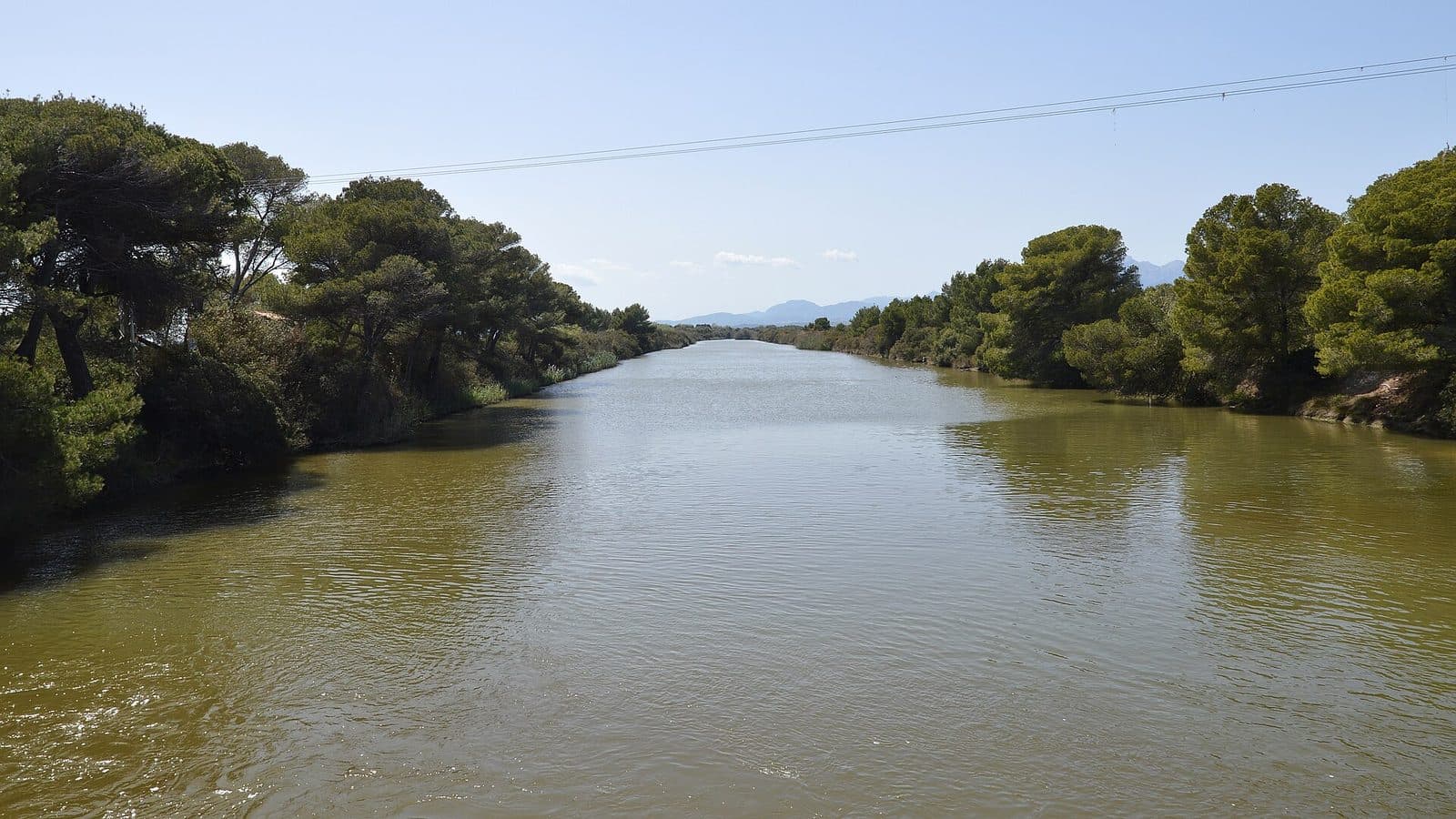

Es Canal Gran reveals a side of Platja de Muro that is easily overlooked during days at the beach. From the viewpoint, the view takes in not only sea and sand but also the broad drainage canal that crosses the s’Albufera wetland and reaches the Bay of Alcúdia here. Hydraulic engineering, coastal scenery, and a nature reserve meet in one place.
The appeal of the site lies less in any single structure than in its unusual perspective. The canal comes from the hinterland, passes beneath the final bridge, and eventually opens into the Mediterranean. At its mouth, known as S’Oberta, it separates two sections of beach. Anyone who pauses here will see that the coast of Platja de Muro is not solely about hotels, dunes, and beach life.
Es Canal Gran is particularly interesting for walkers, landscape photographers, and visitors to the nearby s’Albufera nature park. The viewpoint also works well as a brief stop during a walk along the beach. The focus is on the landscape itself and on the question of how people have tried to alter it. The mouth marks an easily understood transition: on one side lies the wide bay, while on the other the canal draws the eye inland toward the wetland. This contrast is precisely what makes Es Canal Gran a quiet yet revealing place on Mallorca’s north coast.
History and Significance
Behind the broad waterway lies an ambitious intervention in the landscape that ultimately achieved only partial success. The Canal Gran de s’Albufera was created in the second half of the 19th century. It formed part of efforts to drain and reclaim the extensive wetland behind the coast. The reclaimed land was intended for agriculture, but that goal could not be achieved as planned.
The reason lay at the other end of the canal. While water from the wetland was directed toward the bay, salt water from the sea penetrated inland. Salinization severely hindered the planned agricultural use. Es Canal Gran therefore does not tell a simple success story of technological control, but rather reveals the limits of such a project in a sensitive coastal landscape.
During construction, the canal was excavated to a depth of one meter. Its course begins at the confluence of the Torrent de San Miguel and the Torrent de Muro. From there, it runs from west to east through s’Albufera before reaching the Bay of Alcúdia at Platja de Muro. Most of the waterway now passes through the Parc natural de s’Albufera de Mallorca.
Its present-day significance therefore differs considerably from its original purpose. The wetland was not simply transformed into farmland but has instead been preserved and protected as a natural habitat. The canal remained as a visible engineered axis through this landscape. This transformation is particularly easy to understand from the viewpoint: what was once intended to drain the land is now part of the scenery of a nature park visited precisely for its water, wetlands, and birdlife.
The mouth is also an important landmark along the coast. It lies in a central section of Platja de Muro and separates Platja de Ses Fotges to the west from Platja Braç to the east. Es Canal Gran is therefore historical infrastructure, a landscape boundary, and a link between inland areas and the sea at the same time.
What to See
Canal Gran de s’Albufera
The canal defines the entire scene. With a length of 2.7 kilometers and a width of approximately 50 meters, it is not a narrow ditch but a striking corridor through the flat landscape. Its course draws the eye deep into the hinterland. From the coast, the water appears as an open sightline ending not at a building but in the s’Albufera wetland.
Its width in particular helps convey the scale of the drainage project. The banks enclose an expanse of water that differs markedly from the small torrents whose confluence forms the canal. The appeal lies in the horizontal perspective: canal, banks, bridge, beach, and bay can all be read as parts of one interconnected landscape.
S’Oberta
At the mouth, the opening to the sea is known as S’Oberta. Here the canal ends and merges with the open Bay of Alcúdia. At the same time, the mouth divides the beach: Ses Fotges lies to the west, while Platja Braç begins to the east. This gap is so distinctive that it serves as a natural landmark along the long coastal strip.
The view can be appreciated in two directions. Seaward, the wide bay opens up; inland, the eye follows the Canal Gran into the protected plain. Anyone who takes a few minutes here will notice the contrast between the more dynamic coastal setting and the strictly channeled waterway. The close proximity of sandy beach and drainage canal is also immediately apparent—an unusual sight along a stretch of coast otherwise known primarily as a swimming destination.
Pont dels Anglesos
Around 300 meters before the mouth, the Pont dels Anglesos spans the Canal Gran. The bridge forms a clear cross-line over the long water axis and is one of the most prominent landmarks along the lower course. It is not the only crossing: farther inland, the Pont de Sa Roca also spans the canal.
The Pont dels Anglesos is especially important for understanding the viewpoint because the final section of the canal between the bridge and the sea can be seen clearly. From here, visitors can follow how the engineered waterway approaches the coast, as the bridge stands on the lower section of the canal.
Wetland and Coastline
The spatial arrangement of the landscape is one of the main sights. s’Albufera spreads out behind the coast, the bay lies beyond the mouth, and between them the canal carries water through the narrow transition at Platja de Muro. Dunes, beachfront development, and the nature park stand close together without losing their distinct character.
This perspective explains the site better than any isolated detail. The viewpoint shows why water was—and remains—crucial to the history of the area. Anyone who visits the nature park afterward will no longer see the Canal Gran merely as a waterway, but as a visible trace of the attempt to fundamentally reshape the wetland.
Visiting Es Canal Gran
The best place to begin exploring is on the coastal side. From there, first look at the S’Oberta mouth, with the canal on one side and the open bay on the other. It is then worth letting your gaze travel inland toward the Pont dels Anglesos. This simple sequence already makes the canal’s course easy to understand.
Es Canal Gran is more a place for a mindful pause than a destination requiring a long, self-contained sightseeing visit. Anyone who only wants to see the mouth and the sightline can include the viewpoint as a brief stop during a beach walk. More time is worthwhile if you also want to explore the lower section of the canal and the area around the bridge, or combine the visit with s’Albufera.
The experience changes according to the direction of view. From the coast, the connection with the sea dominates; closer to the Pont dels Anglesos, the engineered form of the canal becomes more prominent. For photography, views toward the bay are therefore not the only interesting option: looking inland shows more clearly how the waterway cuts across the flat plain. No single best visiting time can be determined; light, weather, and season significantly alter the appearance of the open landscape.
No fixed opening hours or admission fee are recorded for the viewpoint. As access arrangements or local regulations may change, it is advisable to check current information before traveling. A visit consists of viewing the mouth and canal and understanding their place within the coastal and wetland landscape.
Getting There and Parking
From Palma and the airport, the main route first leads to Platja de Muro. From Palma Airport, the road distance to the town is 62 kilometers, and the journey takes around 53 minutes. The route follows the Ma-30, then the Ma-13, and finally the Ma-3470. From central Palma, the road distance is 59 kilometers, with around 56 minutes to allow for the drive. This route follows the Ma-13 and the Ma-3470.
These distances and travel times expressly end in Platja de Muro, not directly at the viewpoint. For the final section, use the mouth of the Canal Gran de s’Albufera as a landmark. It lies on the coast between the beach sections of Ses Fotges and Platja Braç. Anyone approaching from the town should therefore head not for the extensive interior of the nature park, but for the point where the broad canal reaches the Mediterranean.
The specific choice of parking depends on local signs and the current traffic situation in Platja de Muro. Vehicles should be left only in officially designated parking areas.
It is also possible to arrive by scheduled bus. Nearby stops include S’Albufera 1 and S’Albufera 2, as well as Los Troncos 1 and Los Troncos 2. Which stop is most convenient for a particular journey depends on the direction of travel and the route. The Canal Gran itself remains a useful landmark: its broad water surface and the crossing at the Pont dels Anglesos are clearer reference points than any small, individual viewpoint structure.
Anyone wishing to combine Es Canal Gran with the nature park should distinguish between the coastal mouth and the park entrances when planning the route. Although the canal crosses s’Albufera, viewing it at the mouth is not a substitute for a walk through the protected area. The two places present the same landscape from different perspectives.
Bus lines to Es Canal Gran at a glance
| Line | Route | Departures/day | First | Last |
|---|---|---|---|---|
| 324 | Can Picafort - Alcúdia | 429 | 00:01 | 23:56 |
| 302 | Can Picafort - Palma | 276 | 00:10 | 23:53 |
| 315 | Sa Pobla - Badia d'Alcúdia | 126 | 06:41 | 23:39 |
| A32 | Can Picafort - Aeroport | 104 | 00:15 | 23:32 |
| 325 | Alcúdia - Cala Rajada | 65 | 08:35 | 22:24 |
From the official GTFS feeds (TIB/SFM), no real-time data. The figures cover all stops in the town; weekend and holiday services differ — check with the operator before travelling.
Getting there by bus
S'Albufera 2 (39007) · 0.4 km as the crow flies
- 302Can Picafort - Palma · Daily
- 315Sa Pobla - Badia d'Alcúdia · Daily
- 324Can Picafort - Alcúdia · Daily
- 325Alcúdia - Cala Rajada · Daily
- A32Can Picafort - Aeroport · Daily
S'Albufera 1 (39006) · 0.4 km as the crow flies
- 302Can Picafort - Palma · Daily
- 315Sa Pobla - Badia d'Alcúdia · Daily
- 324Can Picafort - Alcúdia · Daily
- 325Alcúdia - Cala Rajada · Daily
- A32Can Picafort - Aeroport · Daily
Els Pins 1 (39005) · 1.4 km as the crow flies
- 302Can Picafort - Palma · Daily
- 315Sa Pobla - Badia d'Alcúdia · Daily
- 324Can Picafort - Alcúdia · Daily
- 325Alcúdia - Cala Rajada · Daily
- A32Can Picafort - Aeroport · Daily
Els Pins 2 (39004) · 1.5 km as the crow flies
- 302Can Picafort - Palma · Daily
- 315Sa Pobla - Badia d'Alcúdia · Daily
- 324Can Picafort - Alcúdia · Daily
- 325Alcúdia - Cala Rajada · Daily
- A32Can Picafort - Aeroport · Daily
Las Gaviotas 1 (39013) · 1.5 km as the crow flies
- 302Can Picafort - Palma · Daily
- 315Sa Pobla - Badia d'Alcúdia · Daily
- 324Can Picafort - Alcúdia · Daily
Las Gaviotas 2 (39012) · 1.5 km as the crow flies
- 302Can Picafort - Palma · Daily
- 315Sa Pobla - Badia d'Alcúdia · Daily
- 324Can Picafort - Alcúdia · Daily
- 325Alcúdia - Cala Rajada · Daily
- A32Can Picafort - Aeroport · Daily
Timetable data: official GTFS feeds (TIB/EMT), no real-time — check with the operator before travelling.
Nearby Places to Visit
Platja de Muro stretches along the large Bay of Alcúdia between Port d’Alcúdia and Can Picafort. The area is best known for its fine sand and clear, gently shelving water. Hotels and holiday complexes stand behind parts of the beach, while other sections are more strongly characterized by dunes and undeveloped coastline. The mouth of the Canal Gran forms a particularly striking break within this long strip.
Platja de Muro
A visit to Es Canal Gran is easiest to combine with a walk along Platja de Muro. The mouth separates Ses Fotges in the west from Platja Braç in the east, making the beach’s different sections visible at the same time. Instead of walking only parallel to the water’s edge, it is worth making a brief shift in perspective here: the view suddenly no longer follows the coast but cuts across it toward the wetland. This connection with the beach clearly illustrates how the sea, torrents, canal, and wetland are linked.
Parc natural de s’Albufera
The nature park is the most obvious complementary destination. The Canal Gran runs mostly through this protected area, which developed from the wetland that people attempted to drain in the 19th century. Anyone who first views the mouth and then visits s’Albufera will find it easier to recognize the canal’s historical function in the landscape.
The park is particularly well known for nature watching and birdlife. At the Canal Gran, by contrast, the focus is on the broad spatial connection between wetland and bay. The two experiences do more than merely complement each other; they explain one another. In the park, the diversity of the wet habitat becomes visible, while the coast reveals its artificially created outlet to the sea.
Port d’Alcúdia and Can Picafort
Port d’Alcúdia and Can Picafort frame the coastal section of Platja de Muro. Both places work well as additional stops during a day around the bay without reducing Es Canal Gran to a mere waypoint. After livelier promenades or beach areas, the view along the canal feels more restrained and landscape-focused. Visitors with limited time, however, are better off concentrating on the combination of the mouth, beach, and s’Albufera, as this tells the story of the place most clearly.
The place it belongs to
Platja de Muro in the place guidePractical Visitor Information
The site reveals itself through observation: Where does the water come from, where does it flow, how does the canal cut through the plain, and why did the wetland survive despite attempts to drain it? Anyone who considers these questions will experience more than an unnamed break in the beach.
For a more in-depth visit, combine the viewpoint with s’Albufera. At the viewpoint alone, only the lower course of the system can be seen; the nature park makes the wider landscape easier to understand. Conversely, the mouth provides the conclusion that may be missing from a walk solely through the park: here, the Canal Gran, which begins inland, actually reaches the Bay of Alcúdia.