
turó de sa Roca – S’Albufera Views near Platja de Muro
.jpg)
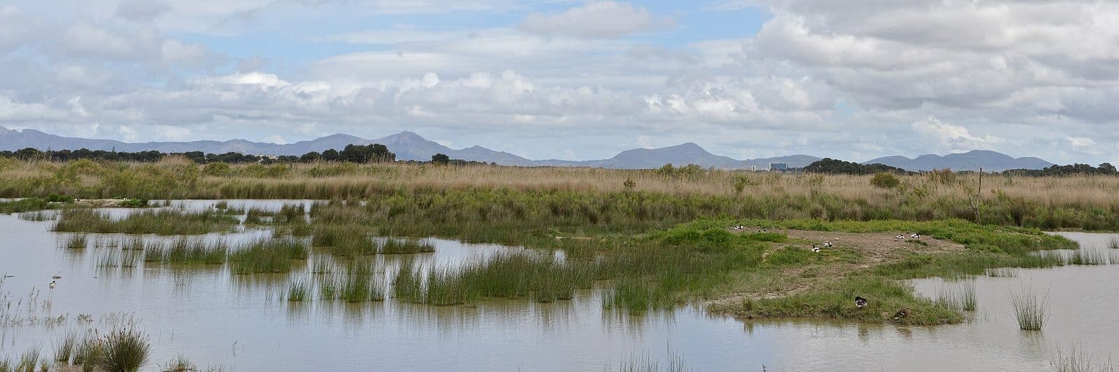
Between the long sandy beach of Platja de Muro and the quieter world of the wetlands lies turó de sa Roca. The viewpoint is not focused on a single structure but on a landscape whose appeal becomes apparent when you pause: open expanses, wetland areas, and the transition between S’Albufera and the coastal strip of the Bay of Alcúdia.
This place is particularly rewarding for nature watchers, photographers, and anyone who wants to discover a side of Platja de Muro beyond its beaches. Rather than a spectacular attraction, what awaits here is a change of perspective. The flat surroundings are easier to understand from an elevated vantage point; seemingly uniform greenery resolves into distinct habitats and sightlines.
turó de sa Roca is best visited as part of a nature excursion around S’Albufera. It can be a brief stop, but it also rewards a longer look through binoculars. Anyone expecting exhibition halls, historic walls, or an extensive visitor program, however, has come to the wrong place: the focus is on the view and the landscape.
What to See
The viewpoint
turó de sa Roca is not a conventional monument that you explore room by room. What matters is its position above the largely flat terrain. Even a comparatively modest elevation changes how the area is perceived: paths, vegetation zones, and open wetlands no longer appear merely as the immediate surroundings but as a connected landscape.
This is precisely what makes the viewpoint worthwhile. From ground level, S’Albufera often reveals itself only in fragments—a path, a canal, an area of reeds, an observation point. From turó de sa Roca, it is easier to see how these pieces of the mosaic relate to one another. The view helps explain how closely water, marshland, and coast lie together in this part of northern Mallorca.
The wetlands of S’Albufera
S’Albufera is regarded as the largest and most important wetland in the Balearic Islands. Large sections consist of marshland; toward the coast, a line of dunes separates the wetlands from the sea. This natural boundary explains the striking contrast in the surroundings: on one side lies the open Bay of Alcúdia with the long beach of Platja de Muro, while on the other is a water-shaped landscape that provides habitat for numerous bird species.
For this reason, the viewpoint is less about a single postcard scene than about patterns and structures. Open expanses alternate with more densely vegetated areas, and different lines stand out depending on visibility. Binoculars are more useful here than a wide-angle lens alone, as many interesting observations take place some distance from the viewpoint.
Sa Roca and the observation points
The name Sa Roca appears in this part of S’Albufera not only in connection with the viewpoint. Other nature observation sites are located nearby, including Can Bateman and the observation points Aguait des Gran Canal, Es Cibollar, and Aguait d’en Bishop. Each offers a different perspective, more closely focused on individual water and wetland areas.
turó de sa Roca serves a different purpose from a sheltered observation hide. It provides an overview, while the surrounding Aguaits are intended for focused observation at closer range. Combining both allows visitors to first gain a sense of the overall layout and then examine individual habitats more closely.
Visiting turó de sa Roca
Arriving and getting oriented
At the viewpoint, it is worth resisting the urge to immediately search for a single subject. A slow look around provides a better understanding of how the landscape is structured. Only then do the smaller differences become apparent: more open areas of water, densely vegetated zones, and the lines along which paths or canals divide the wetlands.
The length of a visit therefore depends greatly on your interests. A short stop is enough for an overview. Anyone who wants to watch birds, take photographs, or combine the viewpoint with other sites in S’Albufera should deliberately keep the schedule flexible. Nature observation does not follow a fixed route, and the same level of activity is not visible in the landscape at all times.
Timing and visibility
Light, weather, and long-distance visibility are the main factors shaping the experience. In clear conditions, the spatial relationships between the wetlands, dune zone, and coast are easier to recognize. When visibility is poorer, attention shifts to the nearby vegetation and possible bird sightings.
There is no reliably documented time of day when the viewpoint is generally less busy. Anyone seeking peace and quiet should avoid fitting the visit into a tightly scheduled beach day and instead leave enough flexibility. Since no fixed opening hours or admission rules have been recorded for turó de sa Roca, it is advisable to check current access conditions before setting out. This is especially important if the visit is to be combined with trails or facilities in the nature park.
From overview to close observation
A logical sequence begins at turó de sa Roca and then continues to one of the nearby Aguaits. From the elevated viewpoint, you can first identify the open and densely vegetated areas. At the observation hides, individual bodies of water and birds then move more clearly into focus.
The viewpoint is therefore suitable as either the beginning or the end of a visit. At the start, it provides orientation; at the end, it helps you see the sections you have explored as a whole once again. Visitors with little time can simply enjoy the overview. Those wishing to delve deeper can turn the stop into a short nature exploration.
Getting There and Parking
From Palma Airport
From Palma Airport, the drive initially follows the Ma-30, then the Ma-13 and Ma-3470 to Platja de Muro. The resort is 62 road kilometers away, and the journey takes around 53 minutes. These details explicitly apply only as far as Platja de Muro; for the final section to turó de sa Roca, you must navigate to the viewpoint’s exact map location within the area.
The Ma-13 covers most of the journey north. After the turnoff toward the Bay of Alcúdia, the route becomes more local, and the destination is not marked by a monumental landmark visible from afar. Navigating directly to the viewpoint is therefore more helpful than relying solely on signs for Platja de Muro.
From Palma
From central Palma, the route follows the Ma-13 and Ma-3470. The distance to Platja de Muro is 59 road kilometers, and the journey takes around 56 minutes. Here too, the measured route ends in the resort rather than directly at the viewpoint. Allow enough time to find your way through the S’Albufera area for the final section.
The final section
turó de sa Roca lies in a natural setting where road access and the actual approach may not coincide as they would at an urban attraction. Before setting out, you should therefore check which access route is currently available and where vehicles may legally be parked. The available information does not indicate that there is a parking area directly at the viewpoint.
Platja de Muro can also be reached by bus. Stops are located in the S’Albufera and Los Troncos areas; from there, the next steps depend on the access route selected. Anyone using public transport should plan the current service and the subsequent walk together rather than simply entering Platja de Muro as the final destination.
Bus lines to turó de sa Roca at a glance
| Line | Route | Departures/day | First | Last |
|---|---|---|---|---|
| 324 | Can Picafort - Alcúdia | 429 | 00:01 | 23:56 |
| 302 | Can Picafort - Palma | 276 | 00:10 | 23:53 |
| 315 | Sa Pobla - Badia d'Alcúdia | 126 | 06:41 | 23:39 |
| A32 | Can Picafort - Aeroport | 104 | 00:15 | 23:32 |
| 325 | Alcúdia - Cala Rajada | 65 | 08:35 | 22:24 |
From the official GTFS feeds (TIB/SFM), no real-time data. The figures cover all stops in the town; weekend and holiday services differ — check with the operator before travelling.
Getting there by bus
S'Albufera 2 (39007) · 1.3 km as the crow flies
- 302Can Picafort - Palma · Daily
- 315Sa Pobla - Badia d'Alcúdia · Daily
- 324Can Picafort - Alcúdia · Daily
- 325Alcúdia - Cala Rajada · Daily
- A32Can Picafort - Aeroport · Daily
S'Albufera 1 (39006) · 1.4 km as the crow flies
- 302Can Picafort - Palma · Daily
- 315Sa Pobla - Badia d'Alcúdia · Daily
- 324Can Picafort - Alcúdia · Daily
- 325Alcúdia - Cala Rajada · Daily
- A32Can Picafort - Aeroport · Daily
Els Pins 1 (39005) · 1.9 km as the crow flies
- 302Can Picafort - Palma · Daily
- 315Sa Pobla - Badia d'Alcúdia · Daily
- 324Can Picafort - Alcúdia · Daily
- 325Alcúdia - Cala Rajada · Daily
- A32Can Picafort - Aeroport · Daily
Els Pins 2 (39004) · 1.9 km as the crow flies
- 302Can Picafort - Palma · Daily
- 315Sa Pobla - Badia d'Alcúdia · Daily
- 324Can Picafort - Alcúdia · Daily
- 325Alcúdia - Cala Rajada · Daily
- A32Can Picafort - Aeroport · Daily
Las Gaviotas 2 (39012) · 2.1 km as the crow flies
- 302Can Picafort - Palma · Daily
- 315Sa Pobla - Badia d'Alcúdia · Daily
- 324Can Picafort - Alcúdia · Daily
- 325Alcúdia - Cala Rajada · Daily
- A32Can Picafort - Aeroport · Daily
Las Gaviotas 1 (39013) · 2.1 km as the crow flies
- 302Can Picafort - Palma · Daily
- 315Sa Pobla - Badia d'Alcúdia · Daily
- 324Can Picafort - Alcúdia · Daily
Timetable data: official GTFS feeds (TIB/EMT), no real-time — check with the operator before travelling.
Nearby Places to Visit
Platja de Muro
The viewpoint reveals a side of Platja de Muro that is easily overlooked beside its famous beach. This stretch of coast extends along the Bay of Alcúdia and is divided into several areas. Alongside more developed beach zones, Es Comú offers a more natural section characterized by dunes and Mediterranean vegetation.
Combining the viewpoint with the beach makes the landscape’s geography particularly easy to understand. From turó de sa Roca, the view extends across the wetlands; at the coast, the role played by the dune belt between the marshland and the sea then becomes visible. Together, two short visits provide a much more complete picture of the area.
S’Albufera Nature Park
S’Albufera was designated a nature park in 1988 and is protected as a wetland of international importance. A combined excursion can include not only the viewpoint but also the network of trails and observation points. Can Bateman, Aguait des Gran Canal, Es Cibollar, and Aguait d’en Bishop are set within the same natural landscape and offer views of different sections of the wetlands.
turó de sa Roca does not replace these observation points. Its advantage is the overview, while the Aguaits offer focused views into individual habitats. Anyone combining several stops should check the nature park’s current rules and access arrangements in advance.
Bay of Alcúdia
For a longer day trip, the viewpoint can be combined with other places around the bay. Platja d’Alcúdia lies to the north, while Can Picafort is southeast of Platja de Muro. Both destinations offer a clear contrast to the quiet nature observation at turó de sa Roca without requiring a journey to another region.
A themed itinerary is more rewarding than a long list of additional stops: begin with wetlands and views, then continue to a beach or coastal town. This leaves enough time to genuinely appreciate the landscape rather than simply checking turó de sa Roca off as a map marker.
The place it belongs to
Platja de Muro in the place guidePractical Information for Your Visit
Binoculars and camera
Binoculars are among the most useful items to bring. The viewpoint provides a sense of space, but many details within a wetland lie beyond the immediate vicinity. When taking photographs, it is also worth looking beyond broad landscape shots to find smaller patterns and movements within the scenery.
Clothing and footwear
Anyone combining the viewpoint with trails in S’Albufera should choose footwear suitable for nature paths. Clothing is best selected according to the weather and wind rather than solely based on conditions at the beach. Water and sun protection should also be included when planning a longer stay outdoors.
Visiting with children
turó de sa Roca is most interesting for children when the visit is presented as a discovery tour. Searching for birds and then comparing different observation points offers more variety than a simple photo stop. Nearby Platja de Muro can easily be included as a second, contrasting part of the excursion; its water remains shallow across extensive areas, making it popular with families.
What not to expect
turó de sa Roca is not a historic tower, museum, or viewing terrace with a tourist entertainment program. Its value lies in the elevated perspective over a sensitive natural landscape. Visitors who observe quietly, respect paths and conservation rules, and allow time for details will experience the place at its best.
Local insider tips
Bring binoculars, not just a wide-angle lens
turó de sa Roca primarily provides an overview. Binoculars are more useful for seeing details across the open wetlands; afterward, a camera can capture the broad lines between marshland, dunes, and coast.
Combine it with the Aguaits
After taking in the panoramic view, continue to an observation point such as Aguait des Gran Canal, Es Cibollar, or Aguait d’en Bishop. The viewpoint shows the whole landscape, while the Aguaits reveal individual habitats.
Two landscapes in one day
Combine the visit with Platja de Muro: at turó de sa Roca, the wetlands take center stage, while at the beach, the dune belt becomes a visible natural divide between S’Albufera and the sea.