
Castell de la Punta de n'Amer: Coastal Watchtower Views
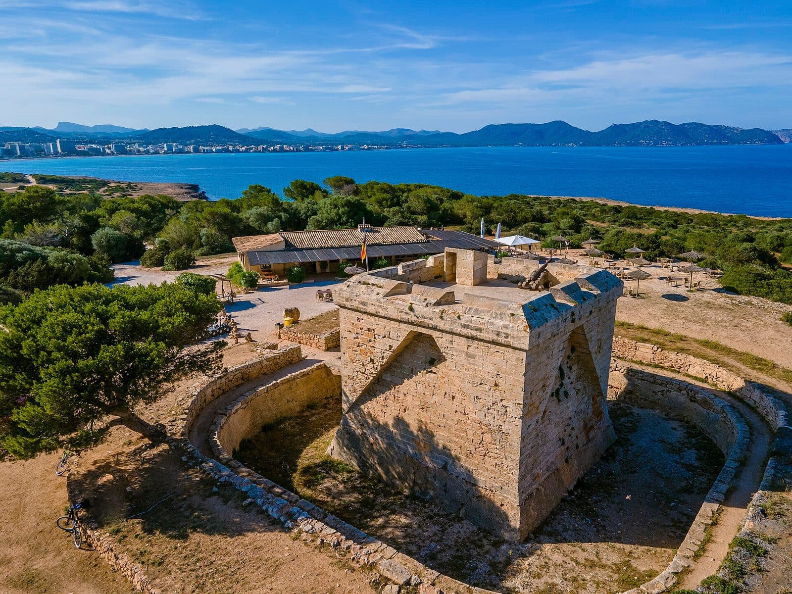

Between a pale sandstone coast, low Mediterranean vegetation, and the open sea stands a squat defensive tower that impresses more through its location than its size. The Castell de la Punta de n'Amer once guarded Mallorca's east coast; today it is a viewpoint, historic site, and destination for a walk through the largely undeveloped coastal landscape between Cala Millor and Sa Coma.
The name suggests a grand castle, but there is no sprawling fortress complex awaiting visitors. This is a compact, fortified coastal watchtower from the late 17th century, also frequently called Castell de sa Punta de n'Amer or simply Es Castell. Its square structure, rock-cut moat, and elevated gun platform vividly illustrate how vulnerable Mallorca's coasts once were.
The interplay between the building and the landscape is especially rewarding. The route follows dirt and sandy paths through a protected natural area before the pale tower appears above the terrain. From the top, views open across the bays near Cala Millor and Sa Coma. Only from this perspective does it become clear why this particular point was chosen for coastal surveillance.
The Castell is suitable for history enthusiasts as well as families and walkers who want to add a manageable excursion to a beach day. The tower itself is compact, so the character of the visit is shaped primarily by the route through Punta de n'Amer. Those who look only at the building see a small fortress. Those who also consider the coastlines recognize a carefully positioned link in the island's historic defenses.
History and significance
A violent attack on Mallorca's east coast in 1611 gave new urgency to long-discussed fortification plans. Raids by North African and Ottoman corsairs were among the dangers of life in the Mediterranean at the time. Punta de n'Amer left a vulnerable gap between the existing observation points.
The attack of 1611
Plans for a fortified watch post on this coast go back further than the present building. However, the final decision in favor of a fortress was made only after the serious attack of 1611. Even then, construction did not begin immediately, as economic difficulties and financing delayed the project for decades. This long prehistory explains why the tower responded to a security problem of the 16th and early 17th centuries but is architecturally a work of the late 17th century.
The site was strategically chosen. From Punta de n'Amer, the bays on both sides of the peninsula could be observed. A gun on the upper platform could be directed against enemy ships approaching Cala Millor or Sa Coma. Its purpose was not to house a large garrison but to provide early detection, deterrence, and armed control of a previously poorly protected stretch of coast.
Construction from 1693 to 1696
Between 1693 and 1696, the Castell took on its present form. Unlike many of Mallorca's slender coastal watchtowers, it was built as a massive square defensive structure. The moat, drawbridge, protected entrance, and roof platform turned the observation post into a small, self-contained fortress. Its garrison could monitor the surrounding area and hold out behind strong walls during an attack.
The compact design was not a scaled-down version of a larger castle but a precise response to its intended task. Every part of the building served either to protect the entrance, accommodate the watch, or provide defense from above. The fact that the Castell seems so isolated today helps explain it: when it was built, there were no rows of hotels or promenades here, only an open and vulnerable coast.
From watch post to historic site
As raids declined in the 19th century, the coastal fortress lost its original military importance. During the Spanish Civil War, the site was used once again, this time as a communications post. Accommodation for soldiers was built beside the Castell; those former military buildings now house food and drink facilities.
The tower is now a historic viewpoint within the protected Punta de n'Amer. The transformation is remarkable: where guards once looked out for enemy sails, visitors now gaze across beaches, bays, and coastal resorts. Yet the original function remains immediately legible. The Castell is explained not only by lengthy information panels but by the horizon it commands.
What to see
The first strong impression comes before reaching the entrance. The tower sits on the rocky terrain like a pale, almost cube-shaped block. No decorative façade distracts from the functional architecture. Instead, the moat, bridge, and narrow openings direct attention to the question of how attackers were kept out and the watch protected.
The square defensive tower
The masonry consists of the pale Marès sandstone commonly found in Mallorca. Its warm hues visually connect the Castell with the rocky ground. The square floor plan distinguishes the building from the island's many round coastal towers and gives it a strikingly solid appearance despite its modest dimensions.
The façades feature narrow defensive openings and projecting elements designed to make the walls more difficult to climb. Much of the construction can therefore already be understood from the outside. The building was not intended as a prestigious seat of power: it has neither a grand hall nor spacious living quarters, instead concentrating every function within a single fortified structure.
Rock-cut moat and drawbridge
A moat cut into the rock surrounds the Castell. It is one of the details that distinguish the tower from a simple observation post. Anyone approaching the entrance must cross this gap by way of the bridge. The entrance was originally secured by a drawbridge and could therefore be controlled by the garrison.
This brief crossing is the most vivid moment of the tour. In just a few steps, the perspective changes from the open coastal landscape to a protected military structure. At the same time, visitors can see how the natural ground was incorporated into the defenses: the moat was carved into the rock.
The vaulted interior
Behind the thick outer walls lies a vaulted room designed for the small watch garrison. Today it contains a small historical display with old weapons, objects, and documents relating to Mallorca's coastal defenses. It is deliberately concise and does not turn the Castell into a large museum. The tower itself remains the main exhibit.
The confined interior conveys something that display boards can explain only with difficulty. The Castell was simultaneously a workplace, shelter, and military readiness post. From here, the route led upward to the platform; outside lay the sea, the bays, and a section of coast whose surveillance demanded constant attention.
The stone spiral staircase
A stone spiral staircase connects the interior with the upper level. It is narrow and one of the visit's characteristic features. The climb changes the scale of the building: below, thick walls and vaulting define the impression; above, the space suddenly opens to the sky and coast. The compact spiral design provides access to the gun platform without cutting through the tower's core.
The gun platform
The roof was the military heart of the Castell. From the platform, the garrison could observe approaching ships and use a cannon to cover the entrances to the neighboring bays. A historic cannon remains there today as a reminder of this function. It is not a decorative addition but helps explain the orientation of the entire building.
Standing beside the gun and looking across the coast makes the logic of the location immediately apparent. The elevated position provides unobstructed views over large parts of the east coast. The wind is more noticeable here than in the protected interior, and the boundaries between scenic viewpoint and former military post begin to blur. Today's panoramic view was once a tactical field of vision.
Views of Cala Millor and Sa Coma
To the north, the view extends toward the bay of Cala Millor; to the south, toward the coast of Sa Coma. Punta de n'Amer separates the two areas like a natural projection into the sea. From above, the contrast between the developed resorts and the undeveloped peninsula is particularly clear.
This view gives the small building its true scale. The Castell does not need to be monumental because its impact comes from its position. Sea, beaches, and flat coastal land arrange themselves around the tower; for a few minutes, an excursion destination becomes an observation post once more.
Visiting the Castell
A visit usually begins not at a ticket office or large entrance gate but on an unpaved path. From Sa Coma or Cala Millor, visitors approach the Castell on foot through Punta de n'Amer. Depending on the chosen path, pine trees, open ground, dune vegetation, sand, and rocky coastal sections alternate along the way. The building only becomes clearly visible above the terrain as the walk progresses.
From Sa Coma to the Castell
The route from Sa Coma begins at the end of the beach. It is particularly appreciated for the way it alternates between wooded sections, open ground, and views of the sea and rocky coast. This turns the tower into the destination of a short coastal hike rather than an isolated photo stop.
Because several paths cross the area, the character of the outward route can vary. Paths close to the coast offer more frequent open views, while sections through the vegetation provide occasional shade. There are no major climbs, but this remains a natural trail rather than a continuously paved promenade.
From Cala Millor to the Castell
From Cala Millor, there are access routes through the beach area and the interior of the natural area. One of the entrances is on the Carrer Castell side. This option works well if the excursion starts in Cala Millor or if the tower is to be included in a longer circuit around the peninsula.
A circular route through Punta de n'Amer combines the seafront promenade, dirt tracks, sandy passages, and sections close to the sea. The complete circuit takes 120 minutes. A visit focused solely on the Castell is correspondingly shorter, though its duration depends mainly on the chosen starting point and how much time is spent on the roof platform, exhibition, and views.
Interior and roof platform
After crossing the moat, the tour leads into the vaulted interior and up the spiral staircase to the roof. The Castell is small enough for its basic structure to be understood quickly. Even so, it is worth resisting the urge to descend immediately: only from the platform can the cannon, bays, and coastline be read as parts of a single defensive system.
Admission is free. Specific opening hours have not been reliably recorded and may change. Anyone who wants to be certain of visiting the interior and roof platform should therefore check current access shortly before the visit. This is especially important outside the main travel season.
Crowds and pacing your visit
Activity around Punta de n'Amer is also influenced by the nearby beaches. The parking area near Sa Coma in particular can fill with beachgoers. It is not possible to identify a universally quiet time from this alone; weather, season, and beach activity can significantly change the experience.
Instead of treating the tower as a quick stop, take time for a calm circuit: first walk around the rock-cut moat, then examine the entrance and façades, explore the interior and staircase, and reserve the longest stay for the platform. This reveals the fortress in the same sequence in which its defenses were conceived.
Getting there and parking
Long-distance driving directions lead as far as Son Moro Bonavista. From there, or from Cala Millor or Sa Coma, paths continue through Punta de n'Amer to the Castell.
From Palma Airport
From Palma Airport, the road distance to Son Moro Bonavista is 72 kilometers. The drive takes around 62 minutes and follows the Ma-15, then the Ma-4030 and Ma-4023. Depending on the chosen starting point, the journey continues on foot through the natural area from either the Cala Millor or Sa Coma side.
The route from the chosen starting point should be added when planning the schedule because the stated driving time ends in Son Moro Bonavista. Yet part of the appeal lies precisely in the walk through the coastal landscape, during which the defensive tower appears in the terrain.
From central Palma
From central Palma, the road route also follows the Ma-15, Ma-4030, and Ma-4023. The road distance to Son Moro Bonavista is 75 kilometers, and the drive takes around 69 minutes. From there, the walk toward Punta de n'Amer follows.
On the return journey, it is sensible to keep the same transition between the walking trail and road network in mind, especially if planning a longer circuit through the natural area.
Parking near Cala Millor and Sa Coma
Possible starting points include parking areas on the Sa Coma side and near Cala Millor. The parking area in Sa Coma also serves the beach and can therefore be very busy. On the Cala Millor side, another parking option lies close to an entrance to Punta de n'Amer and is often described as the more practical alternative for walks.
From either parking area, the route continues over unpaved ground. The access route from Sa Coma begins at the end of the beach, while from Cala Millor visitors can use either a path near the beach or an entrance via Carrer Castell. The choice should therefore depend less on the apparently shortest navigation destination than on the type of walk desired.
By bus
Several bus stops are located in the neighboring residential and beach areas of Son Moro Bonavista, Cala Millor, and Sa Coma. None, however, eliminates the final walk through Punta de n'Amer. The key planning decision is which side of the peninsula the bus journey should end on: Sa Coma provides access from the southern end of the beach, while Cala Millor offers the northern entrances.
Bus lines to Castell de la Punta de n'Amer at a glance
| Line | Route | Departures/day | First | Last |
|---|---|---|---|---|
| A42 | Cala Bona - Aeroport | 336 | 00:13 | 23:22 |
| 401 | Cala Millor - Palma | 328 | 00:09 | 23:48 |
| 424 | Cala Rajada - Portocristo | 172 | 07:55 | 23:43 |
| 425 | Cala Bona - Portocristo | 164 | 07:49 | 22:24 |
From the official GTFS feeds (TIB/SFM), no real-time data. The figures cover all stops in the town; weekend and holiday services differ — check with the operator before travelling.
Getting there by bus
Cala Nau (51013) · 1.6 km as the crow flies
- 401Cala Millor - Palma · Daily
- 424Cala Rajada - Portocristo · Daily
- 425Cala Bona - Portocristo · Daily
- A42Cala Bona - Aeroport · Daily
Estanyol (51014) · 1.7 km as the crow flies
- 401Cala Millor - Palma · Daily
- 424Cala Rajada - Portocristo · Daily
- 425Cala Bona - Portocristo · Daily
- A42Cala Bona - Aeroport · Daily
Palmeres 1 (51006) · 1.7 km as the crow flies
- 401Cala Millor - Palma · Daily
- 424Cala Rajada - Portocristo · Daily
- 425Cala Bona - Portocristo · Daily
- A42Cala Bona - Aeroport · Daily
Palmeres 2 (51005) · 1.7 km as the crow flies
- 401Cala Millor - Palma · Daily
- 424Cala Rajada - Portocristo · Daily
- 425Cala Bona - Portocristo · Daily
- A42Cala Bona - Aeroport · Daily
Savines 1 (51002) · 2.2 km as the crow flies
- 401Cala Millor - Palma · Daily
- 424Cala Rajada - Portocristo · Daily
- 425Cala Bona - Portocristo · Daily
- A42Cala Bona - Aeroport · Daily
Savines 2 (51001) · 2.2 km as the crow flies
- 401Cala Millor - Palma · Daily
- 424Cala Rajada - Portocristo · Daily
- 425Cala Bona - Portocristo · Daily
- A42Cala Bona - Aeroport · Daily
Av. Llevant 1 (51016) · 2.2 km as the crow flies
- 401Cala Millor - Palma · Daily
- 424Cala Rajada - Portocristo · Daily
- 425Cala Bona - Portocristo · Daily
- A42Cala Bona - Aeroport · Daily
Av. Llevant 2 (51017) · 2.2 km as the crow flies
- 401Cala Millor - Palma · Daily
- 424Cala Rajada - Portocristo · Daily
- 425Cala Bona - Portocristo · Daily
- A42Cala Bona - Aeroport · Daily
Bon Temps 1 (51019) · 2.4 km as the crow flies
- 401Cala Millor - Palma · Daily
Timetable data: official GTFS feeds (TIB/EMT), no real-time — check with the operator before travelling.
Nearby places
Only a few steps separate heavily developed resorts from a landscape without an uninterrupted row of hotels along this coast. Son Moro Bonavista lies in the transition area near Cala Millor, with Sa Coma adjoining to the south. Between them, Punta de n'Amer preserves dunes, Mediterranean vegetation, old paths, and rocky stretches of coast. The Castell therefore stands not at the edge of an ordinary urban park but within a protected coastal area.
Punta de n'Amer
The peninsula covers around 200 hectares and is privately owned. It has been protected since 1985; in 1991, it was designated an Area of Special Natural Interest under the natural areas law. For the municipality of Sant Llorenç des Cardassar, it is the only undeveloped section of coast. This history of protection explains the abrupt transition between the resorts and the open terrain around the defensive tower.
Natural and military history meet along the paths. In addition to Es Castell, former sandstone quarries and bunkers from the Spanish Civil War are among the area's historic traces. They need not be turned into a separate sightseeing tour, but they help visitors read the peninsula as a coastal landscape used over a long period.
Cala Millor
Cala Millor is a convenient starting or finishing point for the northern approach. The transition from the promenade into Punta de n'Amer is especially appealing because the development and beach activity are left behind surprisingly quickly. Those returning from the Castell once again reach the infrastructure of a larger resort there.
Sa Coma
On the southern side, the visit can be combined with the beach at Sa Coma. The entrance to Punta de n'Amer lies at the end of the beach. From there, the route leads through changing vegetation and across open sections to the tower. This combination is particularly suitable when planning an excursion from the beach resort rather than the complete circular route.
The full circuit
Those who want to see more than the defensive tower can include it in a circular route through Punta de n'Amer. The complete route is estimated to take 120 minutes. It connects promenade sections with natural trails and passes the coast, vegetation, and historic traces. The Castell forms the cultural and historical focus without reducing the landscape to a mere access route.
The place it belongs to
Son Moro Bonavista in the place guidePractical information for your visit
Punta de n'Amer appears flat and uncomplicated on the map. On the ground, however, firm earth, sand, and rocky sections alternate. Even a brief exterior look may require more than a quick detour because the approach itself is part of the experience. Preparing for a short nature walk is therefore more appropriate than expecting a visit to a museum in town.
Footwear and trail conditions
Sturdy, comfortable footwear is advisable for the unpaved paths. Sandy passages can be soft, while rocky areas may be uneven. The moat cut into the rock and the narrow spiral staircase also demand more attention than a level urban path. Anyone planning the complete circuit should be prepared for changing surfaces.
Sun, wind, and shade
Parts of the route pass through vegetation and offer occasional shade, while other sections are exposed. On the roof platform and along the coast, visitors are directly exposed to sun and wind. Sun protection and drinking water should therefore be included, especially in warm weather, even though the tower appears close to the resorts.
Visiting with children
The paths through Punta de n'Amer are considered easy and are described as family-friendly. The Castell offers several immediately understandable features for children: the rock-cut moat, bridge entrance, spiral staircase, and cannon on the roof. Attentive supervision is nevertheless important around the staircase, moat, and platform. A children's program or large interactive exhibition should not be expected; the experience comes from the authentic building and the route leading to it.
What the Castell is not
Despite its name, this is neither a sprawling knight's castle nor a large museum. There is no sequence of ceremonial halls and no extensive castle courtyard. Visitors see a small, functionally designed coastal fortress with a vaulted interior, compact historical display, and gun platform.
This limitation is precisely what makes the visit convincing. The moat, bridge, staircase, and cannon can be understood without elaborate staging. The most important “exhibition space” is outside in any case: the coast the tower was once meant to guard.
Local insider tips
Walk in from Sa Coma
The route from the end of the beach at Sa Coma passes through varied wooded sections and open ground, with views of the sea and rocky coast along the way. This makes the outward walk an essential part of the Castell visit.
Walk around the moat first
Before entering, it is worth circling the moat cut into the rock. From outside, the unusual square floor plan, protected entrance arrangement, and crossing over the bridge are easiest to understand.
Use the cannon as a sightline
From the roof platform, look along the coast toward Cala Millor and Sa Coma. Beside the historic cannon, it immediately becomes clear which bays the watch post was intended to control and why it was built in this exact location.
Include the Castell in the circuit
A circular route through Punta de n'Amer takes 120 minutes and combines promenade sections, dirt tracks, sandy passages, and coastal stretches. This makes the Castell the historic centerpiece of a landscape walk.
Consider the Cala Millor side
The parking area near Sa Coma is also used by beachgoers and can be very busy. For a walk to the Castell, the starting point on the Cala Millor side is therefore often the more practical alternative.