
Poblat talaiòtic de s'Illot – Mallorca’s Stone Memory
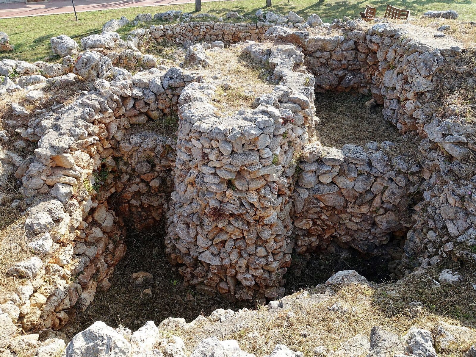

The Poblat talaiòtic de s'Illot feels like a stone-built counterpoint to the holiday resorts on Mallorca’s east coast. Amid modern streets lies a settlement whose history reaches back to the end of the Bronze Age. Massive blocks fitted together without mortar, remains of communal buildings and traces of smaller living spaces show that this was not the site of a single tower, but the home of a community that developed over a long period.
The site’s appeal lies less in spectacular finds than in its readable layout. Raised wooden walkways provide views of walls, rooms and passageways; information panels help turn what initially appears to be a jumble of stones back into a village. A quick glance reveals ruins. Those who take time to study the lines of the masonry will discover neighborhoods, communal buildings and an impressive fortification.
The visit is particularly rewarding for travelers who want to experience Mallorca’s prehistory beyond museum display cases. Families can also use the site to explore how people created monumental architecture without mortar. At the same time, the site is compact enough to combine with a stay in Sa Coma or s’Illot. It does, however, require an attentive eye: The original stonework provides clues, while the paths and panels help visitors mentally reconstruct the missing parts.
History and Significance
For more than a thousand years, people lived, built and made changes here, creating new structures over older remains. The earliest known traces date from the end of the Bronze Age, between 1100 and 850 BC. The buildings that define the site today were constructed over these earlier remains. The Poblat talaiòtic de s'Illot is therefore not a structure from a single historical moment, but the result of numerous alterations and phases of use.
The End of the Bronze Age
The earliest traces of settlement belong to an era before the true flowering of Talaiotic culture. They show that the site was already in use before the monumental stone buildings acquired their later appearance. This is essential to understanding the site: Beneath and between the visible walls lies an older history that cannot always be recognized directly during today’s tour.
These early beginnings developed into a settlement whose layout became increasingly complex. Buildings were not erected in isolation but joined together in groups. Communal buildings formed focal points around which houses and other rooms were added. The village thus grew gradually, following the needs of its residents over many generations.
Talaiotic and Post-Talaiotic Periods
Between 850 and 123 BC, the settlement experienced its most intensive use. This period encompasses Mallorca’s Talaiotic and Post-Talaiotic cultures. Monumental stone buildings were characteristic of the era. They served not only practical purposes but also visibly structured communal life. More recent archaeological research interprets Talaiots as prominent places of assembly and community whose size and appearance were deliberately designed to make an impact on the landscape.
The culture takes its name from the Talaiots, the tower-like megalithic structures found mainly on Mallorca and Menorca. Their walls were built using cyclopean masonry: Large stones were carefully fitted together without mortar. In s’Illot, this construction method can be seen directly in the irregularly shaped and sometimes enormous blocks.
A Village for a Community
The complex was more than a fortified collection of houses. Its layout reveals areas for communal activities as well as spaces used for daily life. The central buildings may have hosted gatherings, food distribution and shared meals. The residents’ houses were grouped around these communal centers.
A substantial wall protected or enclosed the settlement. The survival of a long section makes s’Illot particularly easy to understand among the archaeological sites of eastern Mallorca. The wall conveys more than defensive strength: It also shows that the community clearly organized its living space and was able to invest considerable labor in monumental architecture.
Rediscovery and Research
In the middle of the 20th century, the site once again attracted public and academic attention. A local clergyman drew attention to the settlement in 1955; excavations by the University of Marburg followed in 1965.
The presentation of the site was later fundamentally improved. Wooden walkways, raised platforms and information panels make the village’s structure easier to understand without directing visitors’ attention solely toward individual walls. The excavation site has thus become a place of archaeological learning where not only the settlement’s age and construction methods but also the social fabric of a prehistoric community become visible.
What to See
First impressions can be deceptive: From eye level, many walls appear to form a dense field of rough stones. The picture becomes organized only when viewed from the raised walkways. Defined rooms, adjoining houses and larger building masses then become recognizable. The architecture is therefore best explored step by step—first as an overall plan, then stone by stone.
The Communal Buildings
At the center of the different building groups stand monumental structures that were used communally. They were not isolated towers on the edge of the settlement, but focal points around which further architecture developed. This arrangement reveals much about community life: The center of the village was not defined solely by private homes. Communal spaces occupied a prominent position and linked the individual households. From the walkway, first look for the most substantial walls, then trace how smaller rooms connect to them.
The Houses
The residents’ houses stood around the communal buildings. Mainly their stone foundations survive. Even so, the boundaries of the rooms show that construction did not happen without a plan. Walls divided the available space, created sheltered interiors and connected neighboring units.
These less conspicuous rooms are precisely what make the site a village rather than merely a collection of monumental Talaiots. They direct attention toward everyday life: families, stores of food, meals and work carried out between the large communal buildings. Panels along the paths help identify individual rooms and mentally extend their original form beyond the low surviving walls.
The Round Talaiot and Its Attached Rooms
Part of the site is dominated by a Talaiot with a circular ground plan. Rectangular rooms adjoin this structure. The contrast between the forms is clear: a compact, monumental core on one side and the smaller-scale architecture of the neighboring areas on the other.
The settlement’s growth can be understood particularly well here. The structures do not stand independently but were interlocked. This connection can be recognized by examining where the walls meet. As a result, the village appears not as a complex designed on a drawing board, but as an organism that was continually developed over a long period.
The Inner Talaiot
Another Talaiot stands within the settlement and is also surrounded by attached rooms. Its position emphasizes the importance of monumental architecture to the village’s internal organization. The building was not merely a landmark visible from afar, but part of a dense network of paths, residential areas and communally used zones.
During the tour, it is worth looking beyond the idea of a surviving tower top. What remains of the Talaiots consists primarily of massive foundations and wall structures. Their impact today comes from the strength of the masonry and the difference in scale between them and the lower room boundaries all around.
The Defensive and Boundary Wall
One of the most impressive surviving elements is a long section of a wall that probably once surrounded much of the village. Large stone blocks form a powerful outer line. Their mass is immediately understandable: The construction required planning, materials and communally organized labor.
The wall also helps visitors read the site spatially. Houses and central buildings are concentrated inside its line; beyond it lies the area outside the settlement’s actual core. It was therefore both a defensive structure and a boundary for the community that lived behind it.
Cyclopean Masonry
In many places, large, roughly shaped blocks are stacked so that their weight and careful placement create stability. No mortar was used. The technique is easiest to examine where several courses of stone survive. The gaps, contact surfaces and blocks of different sizes show that the walls were by no means made from randomly piled material. Each stone had to be selected and positioned so that it formed a load-bearing structure with its neighbors.
Wooden Walkways and Information Panels
The modern walkways are more than a convenient way to guide visitors. Their raised position transforms the ruins into an understandable ground plan. From above, rectangular rooms, circular structures, wall connections and the relationship between center and edge are much easier to recognize than from directly among the stones.
Panels with images and descriptions explain the individual areas along the paths. A useful approach is to first examine the illustration on a panel and then look for the same lines on the site. This turns archaeological information into a short lesson in observation: After only a few stops, walls that initially seemed almost indistinguishable begin to stand out.
Visiting the Site
A good tour begins not with the most spectacular individual stone but with an overview. From a raised section of the wooden walkway, visitors can first understand the organization of the complex. It is then worth alternating between the overall plan and the details: first identify the position of a structure, then examine its masonry and the adjoining rooms.
From the Ground Plan to Individual Rooms
The information panels give the visit a useful rhythm. Those who merely skim them will mainly see low walls. Those who compare the illustrations with the site will gradually recognize which rooms belong together and where a monumental building served as the center of a group of structures. The transitions between the Talaiots and the attached rectangular rooms are especially revealing.
There is no fixed amount of time required for the tour. The site is suitable both for a focused archaeological detour and for a slower exploration of every panel. What matters less is the distance covered than the time spent deciphering the architectural forms.
Morning or Late Afternoon
The site is open Tuesday to Saturday from 10 am to 14 pm and from 16 pm to 20 pm. It remains closed between the two time blocks. Anyone combining the visit with the beach, a walk or lunch should take this interruption into account when planning the day and avoid arriving shortly before 14 pm.
There is no reliably documented daily period when the site is consistently quiet. Those who want to read and take photographs with as little disturbance as possible can arrive at the beginning of either opening block instead of in the middle of the time window. The later block combines particularly well with an earlier stay on the coast, while the morning is suitable for an archaeological start before going to the beach.
Admission and What to Expect
Admission costs 3 euros. The archaeological monument itself is the focus of the visit. Paths, platforms and explanations are designed to make the surviving architecture understandable in its original location.
During a short visit in particular, it is worth avoiding giving every wall equal attention. The communal buildings, the round Talaiot with its attached rooms and the surviving section of the large enclosure wall convey the settlement’s essential features most clearly.
Getting There
The archaeological site lies within the developed coastal area near Sa Coma and s’Illot. Unlike many of Mallorca’s prehistoric sites, it therefore requires no hike through remote terrain. When using navigation, however, it is important to select the Poblat talaiòtic de s'Illot or the archaeological settlement specifically: The name s’Illot is also used for other places and coastal destinations on Mallorca.
From Palma Airport
From Palma Airport, the road route follows the Ma-15 to Sa Coma. The journey covers 68 road kilometers and takes around 60 minutes. These figures refer specifically to Sa Coma, not to a parking space directly at the entrance to the excavation site. Within the coastal town, the final section follows local roads toward s’Illot and the archaeological site.
The Ma-15 covers the long stretch across the island. The route becomes more intricate only in the destination area, where Sa Coma and s’Illot meet within a continuous developed coastal zone. For the final streets, the site’s specific name is therefore more useful than entering only s’Illot as a general destination.
From Central Palma
From central Palma, the route to Sa Coma covers 70 road kilometers. The journey takes around 67 minutes and also follows the Ma-15. Here too, the distance and driving time apply as far as Sa Coma; the final journey to the attraction continues through local streets.
By Bus
Nearby stops include Savines 1, Savines 2, Palmeres 1 and S’Illot 2. Which one is most suitable for a particular journey depends on the route and direction of travel. From the stop, the final section is covered on foot through the town. Before traveling, it is therefore advisable to check not only the connection but also the correct side of the road for the return stop.
Because the site lies within a built-up area, combining a bus journey with a short walk through town is generally straightforward. The archaeological site’s full name remains essential for orientation so that visitors do not accidentally head toward a beach or another location with the same name.
Bus lines to Poblat talaiòtic de s'Illot at a glance
| Line | Route | Departures/day | First | Last |
|---|---|---|---|---|
| A42 | Cala Bona - Aeroport | 336 | 00:10 | 23:18 |
| 401 | Cala Millor - Palma | 316 | 00:05 | 23:47 |
| 424 | Cala Rajada - Portocristo | 172 | 07:52 | 23:45 |
| 425 | Cala Bona - Portocristo | 164 | 07:53 | 22:18 |
From the official GTFS feeds (TIB/SFM), no real-time data. The figures cover all stops in the town; weekend and holiday services differ — check with the operator before travelling.
Getting there by bus
Savines 1 (51002) · 0.2 km as the crow flies
- 401Cala Millor - Palma · Daily
- 424Cala Rajada - Portocristo · Daily
- 425Cala Bona - Portocristo · Daily
- A42Cala Bona - Aeroport · Daily
Savines 2 (51001) · 0.2 km as the crow flies
- 401Cala Millor - Palma · Daily
- 424Cala Rajada - Portocristo · Daily
- 425Cala Bona - Portocristo · Daily
- A42Cala Bona - Aeroport · Daily
Palmeres 1 (51006) · 0.8 km as the crow flies
- 401Cala Millor - Palma · Daily
- 424Cala Rajada - Portocristo · Daily
- 425Cala Bona - Portocristo · Daily
- A42Cala Bona - Aeroport · Daily
S'Illot 2 (33068) · 0.8 km as the crow flies
- 401Cala Millor - Palma · Daily
- 424Cala Rajada - Portocristo · Daily
- 425Cala Bona - Portocristo · Daily
- A42Cala Bona - Aeroport · Daily
Palmeres 2 (51005) · 0.9 km as the crow flies
- 401Cala Millor - Palma · Daily
- 424Cala Rajada - Portocristo · Daily
- 425Cala Bona - Portocristo · Daily
- A42Cala Bona - Aeroport · Daily
S'Illot 1 (33067) · 0.9 km as the crow flies
- 401Cala Millor - Palma · Daily
- 424Cala Rajada - Portocristo · Daily
- 425Cala Bona - Portocristo · Daily
- A42Cala Bona - Aeroport · Daily
Mare Selva 1 (51030) · 1.6 km as the crow flies
- 401Cala Millor - Palma · Daily
- 424Cala Rajada - Portocristo · Daily
- 425Cala Bona - Portocristo · Daily
- A42Cala Bona - Aeroport · Daily
Mare Selva 2 (51031) · 1.7 km as the crow flies
- 401Cala Millor - Palma · Daily
- 424Cala Rajada - Portocristo · Daily
- 425Cala Bona - Portocristo · Daily
- A42Cala Bona - Aeroport · Daily
Timetable data: official GTFS feeds (TIB/EMT), no real-time — check with the operator before travelling.
Nearby Places
Few places on Mallorca’s east coast bring prehistoric and modern settlement history into such immediate contact. The ruins are surrounded by the streets of Sa Coma and s’Illot, two coastal towns with accommodation, restaurants and beaches. This makes the excavation an easy addition to a day by the sea without diminishing its historical importance.
Sa Coma
Sa Coma lies north of the archaeological site and is the destination used in the travel information. Its beach and tourist infrastructure make it easy to schedule the archaeological visit before or after a break by the water. Those who visit the settlement in the morning can head to the coast afterward; conversely, the late-afternoon opening block works well after time at the beach.
North of Sa Coma, the Punta de n’Amer peninsula extends between Sa Coma and Cala Millor. It offers a scenic contrast to the stone architecture of the settlement. Anyone combining the two should allow enough time so that the prehistoric site is not treated merely as a hurried stop along the way.
S’Illot and Cala Moreia
S’Illot lies directly on the coast. The town is divided by the Torrent de Ca n’Amer, with a large bridge connecting its two sections. The beach of s’Illot is located at Cala Moreia. From an archaeological perspective, it is remarkable that today’s holiday resort overlaps or surrounds a place that was inhabited and organized long before hotels and promenades existed. This visit always refers to the Talaiotic village near Sa Coma and the coastal town of s’Illot.
Cala Millor and Porto Cristo
Cala Millor to the north and Porto Cristo farther south are convenient destinations for a longer day trip along the east coast. Cala Millor has a more developed holiday-resort setting, while Porto Cristo is a harbor town. Both are best understood as additional stops during the day rather than part of the archaeological tour itself.
Those combining several destinations should ideally visit the excavation first, while they still have the attention and time needed for the panels. The Poblat talaiòtic de s'Illot gains little from a rushed visit shortly before the end of an opening block; its forms become understandable only when the eye can repeatedly shift between the overview and the original walls.
The place it belongs to
Sa Coma in the place guidePractical Visitor Information
The ruins do not tell their story by themselves. A little preparation therefore makes a greater difference here than at an attraction whose rooms and façades survive intact. It is especially helpful to imagine that today’s low stone lines once formed the walls of houses and communal buildings, and that the Talaiots were monumental centers embedded in a dense village fabric.
Read the Site, Don’t Just Look
At the beginning of the tour, it is worth getting an overview from the raised wooden walkways. Only afterward should individual walls be examined more closely. Circular and rectangular ground plans, particularly strong exterior walls and the points where rooms meet other structures are the most important reference points.
The display panels are most useful when compared directly with the corresponding section of the site. A photograph or drawing on a panel often shows more clearly than the ruin alone which walls belong to a room. After several stops, it becomes easier to interpret the next groups of buildings independently.
Visiting with Children
For children, the wooden walkways provide a more understandable view of the ground plan than a route directly between low walls would. The large stone blocks also offer a good starting point for specific questions: How were they moved, why did they remain stable without mortar, and why did the largest buildings stand at the center of the community?
The visit becomes engaging through shared discovery. Instead of reading every panel in full, families can specifically look for the round Talaiot, the attached rectangular rooms and the long enclosure wall.
Understanding the Site
The overall impression emerges from the interplay of original stones, ground plans and archaeological explanation. Those who want to observe how a village developed over more than a thousand years around large communal buildings will find an unusually direct introduction to Mallorca’s prehistory here. The most important subject of the visit is not a single find, but the spatial organization of the entire settlement.
Local insider tips
Get Oriented from Above First
The raised wooden walkways are the key to understanding the site. First view the overall ground plan from above and only then study individual walls—this makes the Talaiots, living spaces and wall connections much easier to read.
Look Closely at the Joints
The cyclopean technique is especially clear in surviving sections with several courses of masonry. The large blocks were set without mortar; their careful placement created stability.
Where Circular Meets Rectangular
At the round Talaiot, look closely at the attached rectangular rooms. The change in form makes the connection between different types of architecture especially visible.
Archaeology Before the Coast
The settlement can easily be combined with Sa Coma or the beach at Cala Moreia. To understand the ruins properly, it is better to take the archaeological tour first and spend time on the coast afterward.
Follow the Great Wall
The long surviving section of the enclosure wall conveys the village’s extent better than any individual building. Following its line reveals where the densely occupied settlement was separated from its surroundings.