
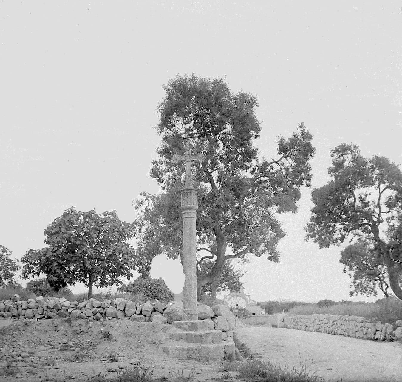
creu de Son Quelles near Felanitx
.jpeg)
The creu de Son Quelles is one of those small historic monuments through which Mallorca’s story can be read in passing. The cross stands near Felanitx in the east of the island and is protected as a cultural asset. Its significance stems from the old Mallorcan tradition of rural and wayside crosses.
The focus is on the dressed stone, the cross’s vertical structure, and the question of why such markers were once erected at entrances to settlements and at crossroads.
A visit is especially worthwhile for travellers who see Felanitx as more than just a starting point for the coast or the eastern mountains. The creu de Son Quelles tells of an era when a cross could simultaneously serve as a religious symbol, a protective sign, and a widely understood marker within the network of paths. It therefore belongs to a cultural landscape that becomes visible only when viewed slowly and attentively.
It is important to identify the site correctly: the creu de Son Quelles is not the large summit cross on the Puig de Sant Salvador, which is also known as Creu des Picot. That cross is likewise located near Felanitx but has a different history, appearance, and visitor experience.
History and significance
Long before road signs, town signs, and digital maps showed the way, stone crosses marked important transitions. They stood at entrances to settlements, forks in the road, and boundaries. In Felanitx, the creu de Son Quelles is understood in this context as one of the local creus de terme, meaning wayside, rural, or boundary crosses. A more recent local-history study is expressly devoted to this group of monuments within the municipality.
The tradition of the creus de terme
According to the historical studies consulted, the development of monumental crosses at entrances to settlements and at junctions gained importance during the Gothic period. Crosses used to mark territories are documented from earlier centuries, but their widespread use as visible stone monuments began later. Mallorca has preserved a particularly large number of examples from this tradition.
Their purpose was not limited to a single function. Such a cross could mark a path or the transition into an inhabited area, but above all it symbolised Christian protection. People moved through a landscape in which religious signs were part of everyday life. Anyone passing a cross therefore saw not merely a waymarker but a familiar image of faith, intercession, and protection.
Historical authors also interpreted the crosses as a Christian response to older beliefs associated with prominent stones and places of transition. This interpretation cannot be read as a specific account of the origins of the creu de Son Quelles. It does, however, explain why boundaries and crossroads were regarded for centuries as places charged with symbolic meaning.
Protected status and its role today
The creu de Son Quelles is designated a Bien de Interés Cultural. This Spanish protection status identifies cultural assets of particular historical interest. The cross is therefore not merely a decorative roadside feature but a recognised part of the cultural heritage.
Its surroundings have inevitably changed today. Modern roads provide orientation, and many passers-by perceive the religious sign primarily as a historical object. Nevertheless, the broader connection between this type of monument and paths, crossroads, and entrances to settlements remains legible.
What to see
At first glance, the upright silhouette is the most striking feature. For a closer look, however, it is worth reading the monument from bottom to top. Local historians distinguish several clearly named components in Mallorcan rural crosses: the substructure, the shaft, the transition to the crowning element, and the cross itself. This vocabulary helps visitors perceive the creu de Son Quelles not merely as an outline but as a structured stone monument.
The substructure
The base determines how the cross is anchored in the terrain and presented to the viewer. Traditional creus de terme have a base known in Catalan as the peu, grada, or base. In historic examples, it may consist of stepped, round, or polygonal forms. The substructure raises the monument above the ground and guides the eye upwards.
When viewing the creu de Son Quelles, this lower section is therefore more than a technical support. It transforms an upright stone into a monument. It also makes especially clear that wayside crosses were designed to be viewed at close range: changes in form, edges, and transitions become apparent only when attention is not focused solely on the crowning element.
The shaft
Above the base rises the shaft, known in Mallorcan terminology as the canya, columna, or fust. It forms the calm vertical centre of the structure. Its purpose is to make the cross visible beyond its immediate surroundings while also connecting the base with the upper pictorial section.
The shaft often appears plainer than the crowning element. This contrast is important: the long, comparatively restrained vertical line guides the eye towards the section where figurative decoration and religious messages are concentrated on more elaborate historic crosses. Anyone photographing the monument should therefore avoid cutting off the shaft. Only the complete line conveys the proportions of a wayside cross.
Capital, node, and transition
In many Mallorcan examples, a compact transitional section lies between the shaft and the cross. Depending on its form, it is referred to as a drum, capital, or node. Historically, this was often a particularly carefully worked area. On old crosses around the island, it could feature saints or the coats of arms of a town, professional association, or donor family.
This general visual language is useful for understanding the creu de Son Quelles without automatically attributing every motif to this individual monument. Close observation is what matters: where does the supporting shaft end, how is the transition to the crowning element handled, and does the depth of the stone carving change there? Questions such as these can make a short stop surprisingly rewarding.
The cross as the crowning element
At the very top sits the creuer, the cross itself and the monument’s principal focus. On the oldest surviving Mallorcan examples, the front and back were often designed differently. Depictions of the crucified Christ on one side and the Virgin Mary with the infant Jesus on the other have been documented, complemented by saints, symbols of the Evangelists, or medallions.
This iconographic tradition explains why historic wayside crosses should ideally be viewed from several sides. The front and back may emphasise different elements, and even a weathered surface changes depending on the viewing direction and angle of the light. At the creu de Son Quelles, therefore, do not look only from the direction of arrival. Where the surroundings provide a safe place to stand, also examine the opposite side.
Stone, weathering, and legibility
An outdoor monument bears different traces from an object in a museum. Edges lose their sharpness, recesses appear deeper or flatter depending on the light, and the overall form often remains easier to read than small details. This ageing is part of the present appearance of a historic wayside cross, but it should not be mistaken for an absence of design.
Side lighting can reveal modelling more clearly than even illumination from the front. Viewing the monument therefore depends not only on the cross itself but also on where you stand. A slight change in perspective often shows more clearly how the base, shaft, transition, and crowning element relate to one another.
Visiting the cross
When viewing the monument, its historic structure and the broader context of this type of landmark can be mentally connected with Felanitx.
A short stop with a close look
Begin by standing some distance away. From this perspective, it becomes clear how the cross acts as a vertical marker within its surroundings. Then let your gaze travel from the base along the shaft to the upper end. Anyone who immediately photographs only the cross shape can easily overlook the fact that the stepped arrangement of the whole structure is an essential characteristic of this type of monument.
A second look should be devoted to the sides and back, provided they can be reached safely. Historic crosses were not necessarily created for a single frontal view. Changing the viewing direction may reveal differences in the workmanship, state of preservation, and effect of the relief.
Historical context
The monument’s value lies in its historical context. This makes the creu de Son Quelles especially suitable as a stop during a walk or exploration of Felanitx, rather than as the sole activity for a long day trip.
Current access conditions should be checked before travelling. Reliable fixed opening hours and a binding admission fee are not included in the available visitor information. The monument should be viewed only from a safe place to stand.
Light and attention
Good visibility and enough time to notice details are more important. Angled light can reveal sculpted sections of the stone more effectively, whereas very harsh light can visually flatten subtle transitions.
The creu de Son Quelles requires little preparation but benefits from some historical background. Anyone who knows that such crosses marked entrances to settlements and crossroads while also being understood as Christian signs of protection will see more than an old stone structure. A fragment of the former order of the road and path network becomes visible.
Getting there and parking
The long-distance route information leads as far as Felanitx. This is important when planning, because the stated distances and travel times end within the town and not at the precise location of the creu de Son Quelles. For the final section, check the exact position of the cross in your navigation system and then pay attention to local signs and traffic conditions.
From Palma Airport
From Palma Airport, the route initially follows the Ma-19 and then the Ma-5120 to Felanitx. The road distance to Felanitx is 46 kilometres, and the journey takes around 41 minutes. From the town, the final section to the cross follows the local road network.
Accurate destination entry is especially useful for a small monument. The name must not be confused with Creu des Picot, the large cross on the Puig de Sant Salvador. A route towards the mountain sanctuary leads to a different attraction.
From central Palma
From central Palma, the route likewise follows the Ma-19 and the Ma-5120. The road distance to Felanitx is 52 kilometres, and the journey takes around 51 minutes. The local access route to the creu de Son Quelles must then be selected.
The Ma-19 covers the longer section from the Palma area towards the east and southeast, while the Ma-5120 continues to Felanitx. In the town itself, the navigation system should not respond only to the name “Creu,” as there are several crosses and similarly named destinations within the municipality.
Parking and the final section
The visitor information does not identify a parking area specifically assigned to the cross. You should therefore stop only where signs and the road layout permit, without blocking access points or moving traffic. A small historic wayside monument does not automatically have the infrastructure of a tourist attraction.
The stops Ernest Mestre 1, Ernest Mestre 2, Polígon de Felanitx 1, and Polígon de Felanitx 2 are listed in the surrounding area. Which is most convenient for your particular starting point and the final section depends on the current service. It is therefore advisable to check the timetable and the subsequent walking route before departure.
Bus lines to creu de Son Quelles at a glance
| Line | Route | Departures/day | First | Last |
|---|---|---|---|---|
| 501 | Manacor - Campos - Palma | 787 | 00:48 | 23:57 |
| 514 | Cala d'Or - Felanitx - Porreres | 110 | 07:00 | 21:35 |
| 512 | Portocolom - Felanitx | 103 | 06:30 | 23:35 |
From the official GTFS feeds (TIB/SFM), no real-time data. The figures cover all stops in the town; weekend and holiday services differ — check with the operator before travelling.
Getting there by bus
Ernest Mestre 2 (22002) · 1.0 km as the crow flies
- 501Manacor - Campos - Palma · Daily
- 512Portocolom - Felanitx · Daily
- 514Cala d'Or - Felanitx - Porreres · Daily
Ernest Mestre 1 (22039) · 1.0 km as the crow flies
- 501Manacor - Campos - Palma · Daily
- 512Portocolom - Felanitx · Daily
- 514Cala d'Or - Felanitx - Porreres · Daily
Polígon de Felanitx 2 (22024) · 1.2 km as the crow flies
- 501Manacor - Campos - Palma · Daily
Polígon de Felanitx 1 (22025) · 1.3 km as the crow flies
- 501Manacor - Campos - Palma · Daily
- 512Portocolom - Felanitx · Daily
República Argentina (22040) · 1.4 km as the crow flies
- 501Manacor - Campos - Palma · Daily
- 512Portocolom - Felanitx · Daily
- 514Cala d'Or - Felanitx - Porreres · Daily
Mossèn Bartomeu Barceló 2 (22032) · 1.6 km as the crow flies
- 501Manacor - Campos - Palma · Daily
- 512Portocolom - Felanitx · Daily
- 514Cala d'Or - Felanitx - Porreres · Daily
Mossèn Bartomeu Barceló 1 (22031) · 1.6 km as the crow flies
- 501Manacor - Campos - Palma · Daily
- 512Portocolom - Felanitx · Daily
- 514Cala d'Or - Felanitx - Porreres · Daily
IES Felanitx 1 (22003) · 2.1 km as the crow flies
- 514Cala d'Or - Felanitx - Porreres · Daily
IES Felanitx 2 (22004) · 2.2 km as the crow flies
- 514Cala d'Or - Felanitx - Porreres · Daily
Timetable data: official GTFS feeds (TIB/EMT), no real-time — check with the operator before travelling.
Nearby attractions
Felanitx provides the appropriate setting for the cross. The town is still strongly shaped by its historic townscape and the agriculture of the surrounding area. In the nineteenth century, it was an important centre of Mallorcan wine production; the phylloxera crisis hit the town and its port hard towards the end of the century. Wine and spirits production later recovered. This history explains why paths, estates, and field names here are more than mere entries on a map.
Felanitx
A visit to the creu de Son Quelles combines well with a walk through Felanitx. The town contains further historical and religious traces of a community that did not primarily develop as a holiday resort. In this context, the cross becomes easier to understand: it belonged to a landscape of settlement, agricultural surroundings, and connecting routes.
Anyone interested in local history can also look out for other historic crosses within the municipality. They should not be regarded as identical repetitions. Differences in structure, state of preservation, and location reveal how varied a seemingly simple monument type can be.
Sant Salvador and Creu des Picot
The Puig de Sant Salvador is one of the best-known excursion destinations near Felanitx. It is home to the sanctuary and the widely visible Creu des Picot. These destinations can be combined with Felanitx on the same day trip, but they must be clearly distinguished from the creu de Son Quelles. The summit cross is a modern monumental structure at a viewpoint, whereas the creu de Son Quelles belongs to the historical tradition of wayside and boundary crosses.
The comparison itself sharpens the eye. On the mountain, distant views and the large silhouette define the experience. At Son Quelles, the focus is on proximity, stonework, and the role of a cross in the old network of paths.
Portocolom and the municipality
Portocolom served as the port of Felanitx and also belongs to the municipality. The relationship between the inland town, agriculture, and the coast shaped local development. Anyone continuing the day trip to the sea is therefore not entering an entirely unrelated setting but following a historical connection within the same municipality.
For the creu de Son Quelles itself, however, Felanitx remains the most important point of reference. Only its connection with the town and its routes turns the cross into more than an isolated photo subject.
The place it belongs to
Felanitx in the place guidePractical visitor information
The key practical advice is simple: look closely. The creu de Son Quelles is an individual historic monument whose quality derives from its form and significance.
A safe viewpoint
Because wayside crosses traditionally stood at entrances and junctions, traffic may be a factor in their surroundings. For photographs or closer observation, choose only a place where nobody needs to step onto the road or block an access point. Walking all the way around the cross is advisable only if local conditions allow this to be done safely.
Clothing and equipment
Sturdy, comfortable shoes are useful if the final section is covered on foot or the ground beside the road is uneven. Sun protection and drinking water are sensible preparations for time outdoors in Mallorca, regardless of how brief the stop may be.
Touching, climbing, or leaning against a protected historic object is inappropriate.
Cultural and historical context
The structure from the base to the crowning cross and the former significance of such markers beside routes provide points of connection with cultural history. Local conditions must be taken into account when viewing the monument.
What not to expect
Images and visitor information relating to the cross at Sant Salvador must not be applied to this site. Anyone looking for a huge summit monument has come to the wrong cross.
Those who appreciate historical traces, however, will find an illuminating stop here. Its effect is quiet and focused: a protected stone marker recalling the old connection between faith, routes, and landscape.
Local insider tips
Read it from bottom to top
Do not photograph only the crowning cross. On historic wayside crosses, the base, shaft, and compact transition beneath the cross belong to the overall composition and explain the monument’s proportions.
Look at the back as well
Mallorcan rural crosses could display different religious images on the front and back. Where the roadside surroundings provide a safe place to stand, it is therefore worth looking from more than one direction.
Do not drive to the summit cross
The creu de Son Quelles is not Creu des Picot on the Puig de Sant Salvador. Check the full name when using navigation, because both crosses are near Felanitx but offer completely different visitor experiences.
Combine it with Felanitx
The cross becomes easier to understand when the visit is combined with a walk through Felanitx. As a historic waymarker, it tells of the relationship between the town, its agricultural surroundings, and the old transport routes.