
Castell de Santueri: Mallorca’s Eastern Rock Castle
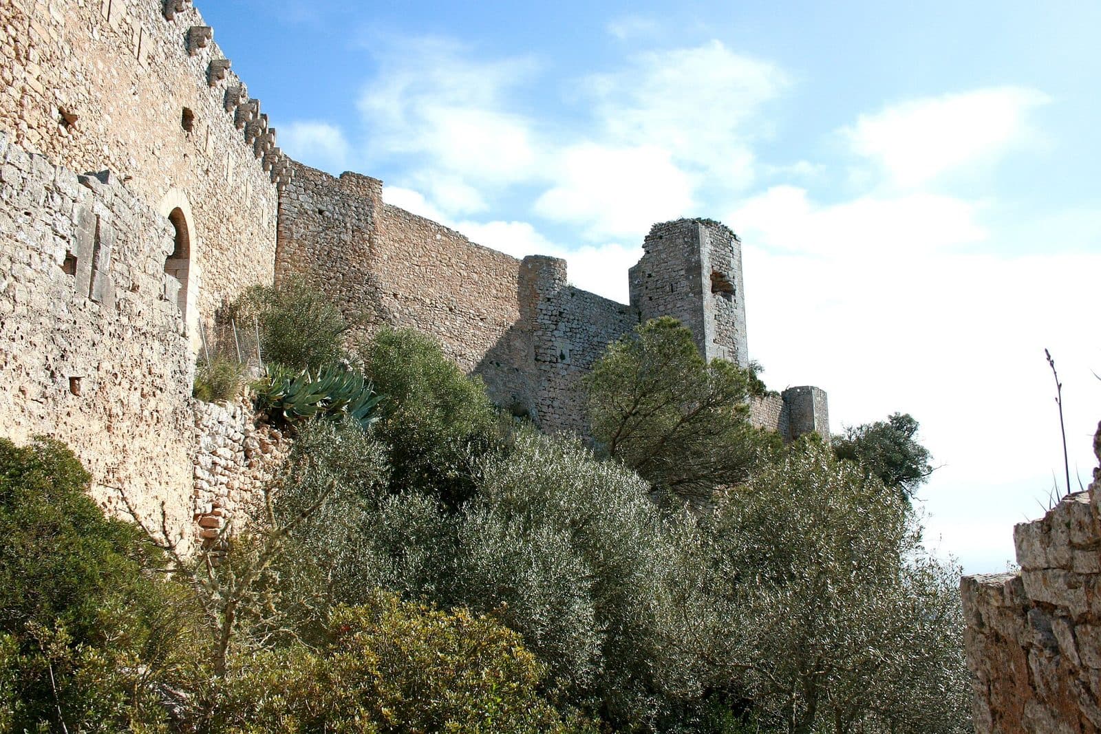

High above Mallorca’s rural east, Castell de Santueri does not follow the floor plan of a courtly residence. Instead, its walls occupy the edge of a table mountain and use the rock itself as part of the defenses. Even from a distance, the pale fortress appears less placed on top than fused with the Puig de Santueri. Its appeal lies in the combination of ruins, landscape and clearly understandable military architecture. Beyond the gate lies not a fully furnished castle but a sequence of clearly identified stations: keep, wall walk, cisterns, oven, quarry, terraces and different sections of wall. Those who explore the site attentively can see how a garrison organized protection, water and supplies on the isolated plateau.
There are also sweeping views across the Serres de Llevant and the southeastern part of the island as far as the coast. On the neighboring ridge, the Santuari de Sant Salvador is a striking landmark. This makes the castle attractive both to history enthusiasts and to travelers seeking a scenic cultural stop away from the major holiday resorts. A visit does, however, require a little more care than a tour through a conventional museum: the final section of the approach is winding, steps lead from the parking area to the entrance, and within the ruins the route is shaped by historic masonry, changing ground levels and open spaces.
History and Significance
For many centuries, the defining feature of the Puig de Santueri remained the same: its isolated plateau commanded views over a large part of eastern and southeastern Mallorca. At the same time, the steep rock faces made an attack more difficult. The castle should therefore not be understood solely as a building, because mountain, slopes and walls together formed the defensive system.
Early Fortifications
Evidence of military use of the mountain reaches back to antiquity. The earliest phase is described as a Roman fortification or watch post. However, the ruins visible today should not simply be interpreted as a Roman complex: the site was repeatedly used, altered and refortified in later centuries. Earlier structures formed the starting point, while the appearance of the surviving castle was shaped primarily by the Middle Ages.
Under Muslim rule, the strategic site was developed into a fortress that was difficult to reach, with the mountain’s natural shape playing a central role. Where steep rocks already provided protection, walls had to secure the edge of the terrain; in more accessible places, controlled entrances, guard positions and additional fortifications were required.
Conquest of Mallorca
When the Christian conquest of Mallorca under King Jaume I began in 1229, Santueri was among the fortified refuges that could not easily be taken because of their location. Historical accounts emphasize the prolonged resistance of the Muslim defenders. This episode in particular illustrates why rock castles were so valuable in military terms: a comparatively small garrison could resist for a long time from a plateau that was difficult to reach.
After the conquest, the fortress passed into Christian hands. It initially went to Nuño Sancho and, following his death in 1241, reverted to the Crown. Santueri was therefore not a remote private castle in the romantic sense, but a royal fortress whose control was important for governing the region.
Medieval Expansion and Loss of Importance
The complex visible today is primarily associated with its expansion in the 14th century. Walls, towers, wall walks and facilities for self-sufficiency had to do more than repel a sudden attack. They were intended to accommodate a garrison and keep the fortress operational even if access from outside was cut off. The numerous cisterns show how seriously this task was taken.
As military conditions changed, the hilltop castle later lost its defensive function. From the 18th century onward, it was no longer needed in the same way and gradually fell into ruin. What appears today as an impressive whole is therefore the result of many phases of use, alterations, damage and stabilization.
Preserving the Ruins
Restoration and stabilization work made the long-endangered site accessible to visitors again. The operator’s website specifically documents a restoration phase from 2010 to 2011; other sources describe work in subsequent years. The aim was not to rebuild a supposedly original castle in full. Instead, surviving walls, endangered building remains and parts of the vaults were secured without removing the site’s character as a ruin.
Today, Santueri can be classified as one of Mallorca’s rock castles. Its value lies precisely in the fact that its military logic can still be read in the terrain: a controlled entrance, walls along the edge of the plateau, towers at important sections and a water supply designed with possible sieges in mind.
What to See
The official route does not simply lead from one viewpoint to the next. Instead, its stations explain how the fortified entrance, living and supply areas, and individual stretches of wall worked together. The complex is best understood by paying attention not only to the large towers but also to openings, edges of the terrain, water tanks and worked rock.
Gate and Guardhouse
The entrance to the castle was the most vulnerable point of the entire complex. A significant part of the defensive architecture is therefore concentrated around the access point. The official route identifies an arrow-slit gate and the guardhouse here. This opening section already makes clear that arrivals did not pass directly onto the open plateau but had to move through a monitored and architecturally controlled bottleneck.
At the gate, it is worth examining the relationship between the wall and the natural ground. Santueri does not rely on uniform fortifications everywhere. The architecture responds to the rock, closes off accessible passages and directs the route to where the garrison could watch it.
Torre de l’Homenatge
The keep, known in Catalan as the Torre de l’Homenatge, is one of the fortress’s most striking remains. Such principal towers were not merely highly visible symbols of power; they also formed a particularly protected point within the complex and rose above important sections of the fortifications.
At Santueri, the tower should always be viewed in relation to the plateau. Its impact comes less from a decorative façade than from its position above the entrance and within the defensive complex as a whole. Pale masonry, massive wall surfaces and proximity to the plateau’s edge still convey the castle’s forbidding character.
West Wall and Wall Walk
A wall walk is marked along the west wall. Here, the defenders’ daily work becomes especially tangible: walls not only had to be high and strong but also had to be monitored. The walkway allowed movement along this section of the fortifications and connected observation and defensive positions.
Walking along the wall also changes the perception of the landscape. From inside, it appears as the boundary of the castle; from its viewpoints, it becomes the line from which the surrounding countryside could be watched. The view toward the neighboring ridge with Sant Salvador helps explain the strategic position within the relief of the Serres de Llevant.
Oven and Castellan’s Room
An oven and the chamber identified as the room of the castle lord or castellan are reminders that the fortress was also a place to live and work. The military garrison needed food, warmth and organized accommodation. Everyday life between the defensive walls was therefore far less heroic than later tales of sieges suggest.
Do not expect fully furnished living quarters among the former rooms. Yet the fragmentary foundations and building remains invite visitors to interpret their location: short routes to the defensive sections, protected areas within the walls and proximity to supply facilities.
Main Cistern
The main cistern is one of the most important structures on the route. On a rocky summit without a reliable natural watercourse, stored rainwater determined how long people could remain there. A castle could have strong walls and still quickly become untenable if its water supplies failed.
Santueri did not rely on a single tank. The route also leads to a room with attached cisterns and another cistern along a section of wall. This distribution shows that water storage was not a minor detail but part of the fortress’s essential infrastructure. The tanks are therefore at least as revealing as the towers.
Southwest Wall and Square Towers
The wall section and square towers are the focus of the southwestern area. The towers divide the fortifications and created positions from which adjacent sections of wall could be monitored. Their sequence follows no ceremonial rhythm but instead reflects the requirements of the terrain.
This area shows particularly clearly why Santueri is described as a rock castle. The fortifications run along the edge of the plateau and complement its natural steepness. Walls had to be strong where the mountain permitted access; elsewhere, the sheer drop itself formed the greatest obstacle.
Room with Attached Cisterns
The room with adjoining water tanks adds further depth to the subject of supplies. Where individual wall shells and tanks can be seen today, there was once a technical system for collecting, channeling and storing water. Without this infrastructure, an extended stay on the plateau would have been almost unthinkable.
This area is easily overlooked because it lacks the height of a tower and the visual impact of a wall. Yet it is central to understanding the castle: Santueri was not merely an observation post but a fortified living environment that at times had to function independently of its surroundings.
South Wall and Quarry
At the south wall, the official route leads to a quarry area. Here, the relationship between the building and the mountain is particularly immediate. Material for parts of the fortress could be extracted from the exposed rock, and working the stone also left marks on the terrain.
The quarry shifts attention away from the finished masonry and toward its creation. Every block had to be cut out, shaped and moved into the correct position. On a mountain plateau, this was a considerable undertaking. The pale walls therefore appear not as a foreign body but as a continuation of the limestone in worked form.
Lower Terrace
Another section of wall connects with a cistern and the lower terrace. The change in elevation reveals that the castle’s interior is not a completely level surface. Terraces and stepped areas helped make the irregular terrain usable and organize different functions across the plateau.
From lower positions, the walls and towers appear different than they do from the upper areas. This change of perspective is important to the route: only from several viewpoints does it become clear how closely the architecture and topography were coordinated.
Northeast Tower and North Wall
The northeastern wall section with its tower and the north wall complete the official route through the defensive zones. From this side, the view turns more strongly toward the mountains and the neighboring Puig de Sant Salvador. The wall also marks the transition between the secured interior and the steep outer slope.
Along the northern sections, it is worth looking once more at the irregular course of the walls. Santueri does not follow an ideal geometric plan. The castle’s perimeter is determined by the plateau, and the wall adapts to its edges. This is precisely what makes the complex so vivid and instructive.
Views Across Eastern Mallorca
Between the wall sections, wide views open across the Serres de Llevant, the agricultural plain and the southeastern coastal region. Portocolom can be identified as a landmark toward the coast; on the neighboring ridge, the Santuari de Sant Salvador and its distinctive buildings stand out.
The view is more than a beautiful addition, because it explains the location. From Santueri, roads, settled areas and approaches across a large region could be observed. Looking first at the landscape and then back at the wall walk, towers and gate provides a better understanding of the fortress than considering individual walls alone.
Visiting Castell de Santueri
The tour begins below the walls. A stepped footpath leads from the small parking area to the entrance. These final minutes make the castle’s location physically tangible: the destination is not in a town center but on a difficult-to-reach rocky plateau whose natural slopes once contributed to its defense.
Route Through the Complex
Beyond the entrance, the castle can be explored by following the official stations. The route leads from the gate and guardhouse to the keep, then along different stretches of wall and onward to the former living and supply areas. Cisterns, quarry and lower terrace give the tour a clear thematic structure.
The time required depends greatly on whether visitors seek only the view or examine every station. No reliable general duration for a visit is specified. Anyone who reads the information, studies details in the masonry and considers the relationship to the landscape from several points should not plan the visit as a brief photo stop. The paths within the ruins and the varying ground levels call for a slower pace in any case.
Finding Your Way on Site
The operator’s website provides a structured visitor route that can also be followed on a smartphone. This is especially helpful because many rooms survive only as ruins. Without labels, a water tank could easily be mistaken for a simple hollow, or a former living area for an inconspicuous remnant of wall.
The most rewarding approach is to follow the specified order. This turns individual remains into a coherent whole: first access and defense, then wall walks and living areas, followed by water management and further sections of the curtain wall. Views across the landscape accompany these themes but do not replace them.
Time of Visit and Weather
Open spaces shape the visit on the plateau. In strong sunshine, protected indoor areas are absent for long stretches, while wind and changing weather can be felt more clearly at this exposed elevation than below in S’Horta or Felanitx. A time of day when the sun is no longer at its strongest can therefore be more comfortable, although this does not allow any reliable conclusion about particularly quiet hours.
Opening hours and admission prices can change and should be checked before setting out. This is especially important at Santueri because a closed entrance cannot be replaced by a freely accessible route around the entire castle. The official operator’s website is the authoritative source.
Character of the Experience
Santueri is above all a historic ruin that can be explored on foot. Expect stretches of wall, towers, cisterns, terraces and views, not the succession of rooms found in a fully preserved castle. The experience comes from reading the terrain: Where was water stored? Which passage could be controlled? Why does a tower stand in this particular place?
Visitors who bring these questions with them will discover a remarkably vivid fortress. Those expecting furnished halls, major collections or an elaborately staged interior exhibition will miss the site’s true character.
Directions and Parking
The distances and driving times provided in the page data lead to S’Horta, not directly to the castle gate. From Palma Airport, the road distance is 50 kilometers; the journey takes around 50 minutes via Ma-19, Ma-5120 and Ma-14. From central Palma, the road distance is 56 kilometers with a driving time of around 59 minutes, also via Ma-19, Ma-5120 and Ma-14.
The Final Stretch to Puig de Santueri
From S’Horta, local roads continue toward Puig de Santueri. Another commonly used approach comes from Felanitx: the mountain road to the castle branches off the Ma-14 toward Santanyí. Because the stated totals explicitly end in S’Horta, additional time should be allowed for the onward journey rather than relying on the data module’s driving time as if it extended all the way to the attraction.
The upper section of the mountain road becomes winding, narrow and steep. Oncoming vehicles may require attention and, where necessary, slow maneuvering to pass. The approach is part of the experience but should not be underestimated: drivers should keep their eyes on the road, while the views can be enjoyed more safely from the parking area and inside the castle.
Parking and Footpath
A small parking area lies below the fortress wall. Its limited size means visitors should not expect a spacious tourist parking facility. After leaving the vehicle, a short stepped footpath still leads to the entrance. The visit therefore does not begin directly at the car door.
Sturdy footwear is advisable even for this final section. After rain or where loose material is present, steps and rocky areas may require greater care. The same caution should be planned for the descent as for the drive up, particularly on bends with restricted visibility.
Arriving Without a Car
No bus stop is recorded in the immediate vicinity of the castle. A bus journey into the region therefore does not automatically solve the final section up the mountain. Anyone traveling without a private vehicle must arrange the onward journey or plan a correspondingly longer walk in advance.
A hiking route should not be confused with the short staircase from the parking area. There are routes from the S’Horta area and a more demanding connection from the direction of Sant Salvador; these are independent hikes over partly rocky and scree-covered paths, not a simple approach from a nearby stop.
Bus lines to Castell de Santueri at a glance
| Line | Route | Departures/day | First | Last |
|---|---|---|---|---|
| 514 | Cala d'Or - Felanitx - Porreres | 33 | 06:42 | 21:17 |
From the official GTFS feeds (TIB/SFM), no real-time data. The figures cover all stops in the town; weekend and holiday services differ — check with the operator before travelling.
Getting there by bus
Es Carritxó 1 (22042) · 2.1 km as the crow flies
- 514Cala d'Or - Felanitx - Porreres · Daily
Es Carritxó 2 (22043) · 2.1 km as the crow flies
- 514Cala d'Or - Felanitx - Porreres · Daily
Timetable data: official GTFS feeds (TIB/EMT), no real-time — check with the operator before travelling.
Nearby Places
S’Horta, a small village in the municipality of Felanitx, lies between the castle and the holiday resorts of the southeast coast. It is a useful landmark for the approach and also reveals the region’s rural side: behind the coast, fields, scattered houses and the ridges of the Serres de Llevant define the landscape.
S’Horta and the Southeast Coast
From S’Horta, a castle visit can easily be incorporated into a day in southeastern Mallorca. Portocolom and other coastal places lie toward the sea; from the fortress plateau, it becomes clear how closely mountains, cultivated plains and sea come together in this part of the island. Rather than scheduling several extensive sightseeing stops in quick succession, a relaxed village or coastal stop is a better choice after Santueri.
Portocolom is also a landmark in the view from the castle. The harbor town does not have to become a second major item on the itinerary: even a drive in that direction illustrates the transition from the fortified heights down to the coastal landscape.
Felanitx
Felanitx lies on the other side of the Puig de Santueri and is traditionally an important starting point for the approach. The route via the Ma-14 passes through the countryside at the foot of the eastern ridges. Those seeking places to eat or a walk through an established Mallorcan town can combine the castle with Felanitx without traveling far outside the region.
The town also helps place the castle in its historical context. Santueri was not an isolated fantasy structure on a mountain but controlled a strategic area with settlements, roads and agriculturally usable land below the walls.
Santuari de Sant Salvador
The most obvious scenic complement is the Santuari de Sant Salvador on the neighboring ridge. Its silhouette is clearly visible from Santueri. Both places offer elevated viewpoints but tell different stories: here a defensive rock castle with cisterns and curtain walls, there a religious summit site.
Combining both destinations by car is easier than hiking directly between the heights. The well-known walking route follows narrow paths with rocky and scree-covered sections and should be treated as a proper hike requiring suitable preparation. For a normal sightseeing day, driving between the starting points is the more relaxed choice.
The place it belongs to
S'Horta in the place guidePractical Visitor Information
Between the parking area, gate, terraces and stretches of wall, Santueri remains a historic site. Restoration has secured endangered areas, but it has not turned the castle into a level museum building. Preparation can therefore be simple but should be thoughtful.
Footwear and Terrain
Closed shoes with grippy soles are better suited to the terrain than smooth sandals. Even the stepped path from the parking area requires some sure-footedness; inside the complex, visitors encounter uneven ground, historic masonry and changes in elevation. At viewpoints in particular, do not focus on the landscape and your footing at the same time: stand securely first, then enjoy the panorama.
The marked stations are spread across different parts of the plateau. Anyone wishing to see every section of wall, the cisterns and the lower terrace will walk farther than the compact fortress might initially suggest.
Sun, Water and Weather
Large parts of the route are outdoors. Sun protection and sufficient drinking water are therefore sensible equipment, especially on warm days. The historic cisterns explain the former water supply but are, of course, not modern drinking-water points.
At this exposed elevation, wind and weather can become noticeable more quickly than in the places below the mountain. A light extra layer is useful in changeable conditions. In intense heat, the tour should be taken more slowly and not squeezed into an already overcrowded day.
Visiting with Children
The castle can be exciting for children because the gate, towers and water tanks are immediately recognizable, and there are no long museum halls to cross. Secured areas make a family visit easier. Nevertheless, the site remains a ruin with steps, uneven ground and open outdoor areas. Young children therefore require constant supervision, particularly near walls, edges of the terrain and transitions between terraces.
A simple story works better than an abundance of dates: Where might guards have stood, where was rain collected, and how did supplies reach the mountain? Questions like these make even inconspicuous wall remains understandable.
What Not to Expect
Santueri is not a restored residential castle with furniture, state rooms and enclosed galleries. Many former rooms can be interpreted only through their walls, location and names. The focus is on the structure, its supply systems and its connection to the rocky plateau.
Nor is the castle a quick viewpoint directly beside a main road. The narrow mountain approach, small parking area and footpath to the entrance are all part of the visitor experience. Those who are prepared for this and check opening details and weather in advance will see a place where Mallorca’s medieval defenses do not need to be explained in the abstract: they can be read step by step in the terrain.