
Mirador de na Torta near Valldemossa
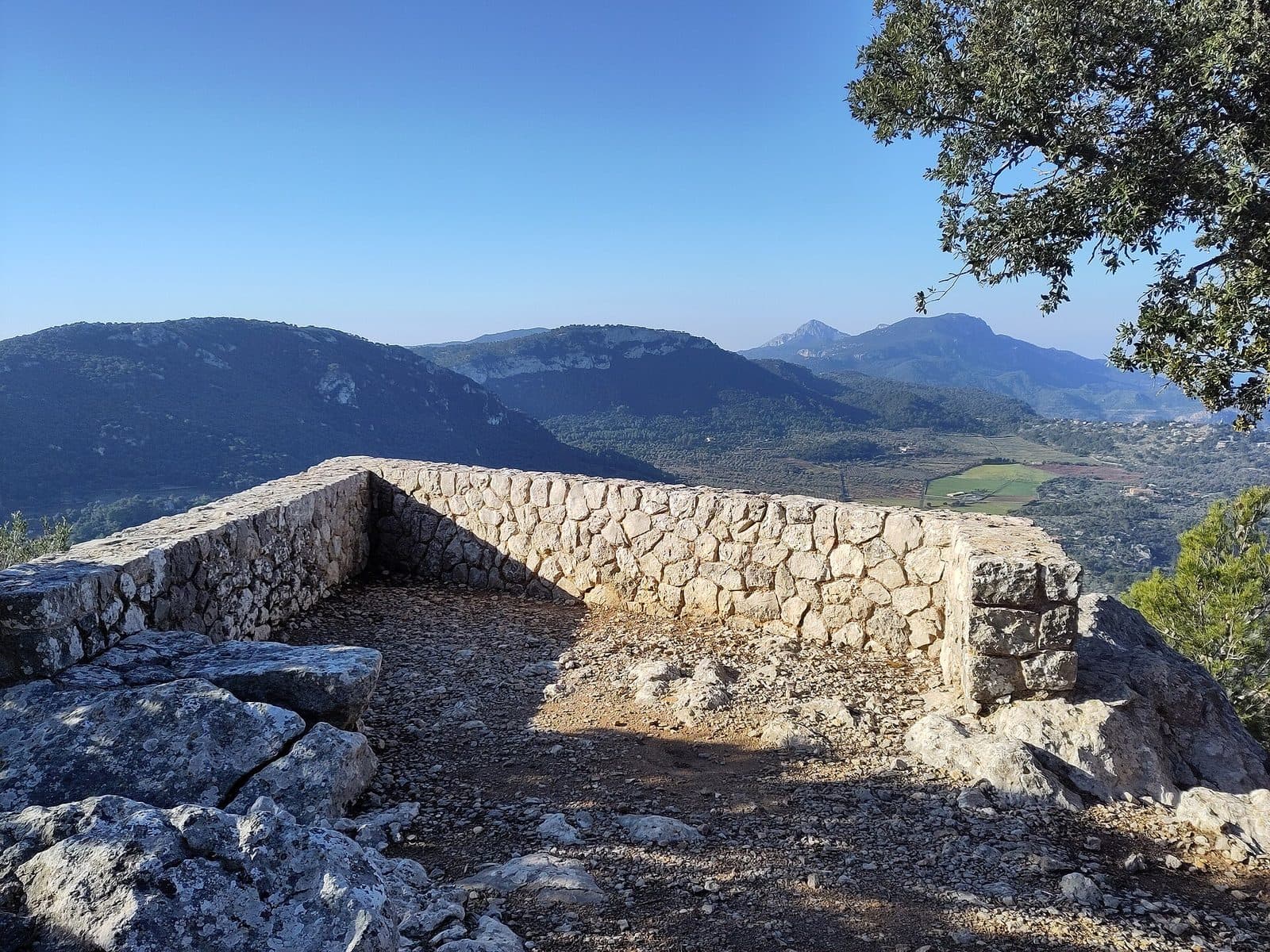

The Mirador de na Torta lies above Valldemossa in the mountain landscape of the Serra de Tramuntana. The viewpoint is the destination of a proper hike: the trail climbs from the village through dense holm oak forest, crosses the expansive Pla des Pouet and finally reaches the western rocks of na Torta. From there, views open across the Son Moragues estate.
It is precisely this approach that makes the hike so appealing. The panorama does not appear immediately after you step out of a vehicle, but at the end of a steady ascent. Along the way, the edge of the village, a stream, forest and a high plateau shaped by traditional land uses follow one another. Na Torta is therefore less a quick photo stop than a compact introduction to the cultural landscape above Valldemossa.
The hike is suitable for visitors who want to experience Valldemossa as more than a village of lanes and historic buildings. However, it requires fitness for a significant elevation gain, suitable footwear and the ability to navigate a branching network of trails.
Na Torta is also particularly rewarding as a deliberate alternative to the longer mountain hikes in the surrounding area. The Mirador belongs to the trail network around the Pla des Pouet, but visiting it does not necessarily require walking the entire Camí de l’Arxiduc. This makes it possible to combine a varied scenic ascent with a clear destination.
What to See
The rocks of na Torta
Na Torta is the rocky area on the western slope of the Pla des Pouet. Its cliffs already appear on the left above the forest during the ascent; at the viewpoint itself, the mountainside previously visible only in sections gives way to an unobstructed panorama. The rocks overlook Son Moragues and form a natural balcony above the terrain west of Valldemossa.
The focus is on the rocky setting and its position above the landscape.
The perspective differs markedly from the view in the streets of Valldemossa. Below, house façades and narrow lanes dominate the scene; above, it becomes clear how close the village lies to the steep foothills of the Tramuntana. From na Torta, Son Moragues appears not as a single group of buildings but as part of an extensive mountain and forest landscape.
The holm oak forest
The path to the viewpoint initially follows the stream that descends from the Font de s’Abeurada spring. After crossing between the Son Gual and Son Moragues estates, the trail climbs northward. It passes through dense holm oak forest that is more than mere scenery: at first, it largely blocks distant views and turns the hike into a sequence of enclosed and open spaces.
Between the trunks, the rocks of na Torta remain an important landmark on the left. The Camí de les Basses area lies to the right. This gives the ascent a clear scenic progression: the stream-cut hollow below, the enclosed forest above and finally the more open plateau. Only near the destination does the view take centre stage.
The forest also explains why the route does not feel like a walk around the edge of the village, despite its proximity to Valldemossa. After the final streets, the buildings quickly disappear from the immediate surroundings. Uneven natural ground, gradients and branching mountain paths now define the route.
The Pla des Pouet
The Pla des Pouet is the central landmark of the hike. The broad, relatively level area lies at the foot of Talaia Vella and is distinguished by a spring with a watering trough. Reaching it after climbing out of the forest brings a noticeable change: the trail temporarily loses its enclosed character, and several routes spread across the plateau.
Traces of former work and land use can be seen on the Pla des Pouet. These include abandoned structures and circular sites once used by charcoal burners. Evidence of hunting activity can also be found in the area. These unobtrusive remains show that the heights above Valldemossa were not untouched wilderness. Forestry, water supply, hunting and the routes between estates all helped shape the landscape.
The spring and its watering trough give the plateau a clearly defined focal point. Its significance comes primarily from its location: routes towards na Torta, Mirador de Can Costa, Refugi de l’Arxiduc, Pas d’en Miquel, Ses Fontanelles and Camí de l’Arxiduc converge here. Anyone who does not pay close attention to the chosen route can therefore easily follow a different trail.
The trail network of the Archiduque area
One of Valldemossa’s best-known hiking landscapes begins around the Pla des Pouet. The Camí de l’Arxiduc crosses the Caragolí and follows a longer circuit over the heights back towards Valldemossa. Smaller paths also provide access to additional viewpoints and mountain passes. The Mirador de na Torta is part of this network but remains a destination in its own right.
This distinction is important because digital route suggestions often combine several viewpoints and mountain sections into one long circuit. Such a hike is not the same as a direct visit to na Torta. A shorter out-and-back hike is sufficient for the viewpoint; adding other destinations considerably changes the length, elevation profile and demands.
For this reason, more than the major trail names matter on the ground. Small junctions determine whether the route continues to the western rocks, the Camí de l’Arxiduc or another Mirador. A route prepared in advance is more useful here than expecting the plateau to guide you automatically to the correct viewpoint.
Visiting Mirador de na Torta
From the edge of the village into the forest
The usual approach begins in Valldemossa on Avinguda de Palma. From there, it follows Carrer Venerable Sor Aina towards the football ground and municipal cemetery. At the football ground, continue along Carrer del Pintor Joan Fuster and then into Carrer de ses Olives. At the end of this street, the ascending trail to the Pla des Pouet begins to the left of a gate.
The transition from the village into the mountain landscape happens surprisingly quickly. At first, the streets, sports ground and cemetery serve as easily recognisable landmarks. Beyond the final street section, the path follows the stream valley and steadily gains elevation through the holm oak forest. The rocks of na Torta remain on the left, while the Camí de les Basses area lies to the right.
The described route covers a total of 3.5 kilometres on streets and trails, gains 250 metres in elevation and takes around two hours. These figures refer to the hike, not to time spent in the village or to an extension via other viewpoints. Photo stops, a longer stay at the Mirador and navigating junctions can lengthen the excursion.
At the Pla des Pouet
After most of the climb, the trail reaches the Pla des Pouet. Here, it is worth resisting the temptation simply to follow the broadest track. Although the multitude of routes is part of the area’s character, it also makes a clear route choice essential. The well-known Camí de l’Arxiduc in particular draws hikers farther into the heights, while na Torta lies among the western rocks of the plateau.
The plateau is also a good place to put the route so far into context. The spring with its watering trough, abandoned structures and charcoal-burning sites are concrete landmarks. At the same time, it becomes clear that the Mirador is only one destination in a much larger historic trail network. Anyone wishing to visit only na Torta should not be spontaneously drawn by signs towards more distant mountain destinations.
At the viewpoint itself, the landscape determines the length of the stay. Some hikers are content with a short break and the view across Son Moragues, while others take time to appreciate the perspective from several safe standing areas.
Best time to visit and crowds
Because access in mountain areas and on trails crossing estate land can be subject to changes or restrictions, the current trail conditions should be checked before setting out. The same applies to any notices at the trailhead and gates along the route. An open-looking trail is no substitute for up-to-date access information.
There is no reliable time when na Torta can generally be expected to be empty. The Pla des Pouet is a starting point and junction for several popular routes, including the heavily used Camí de l’Arxiduc. The ascent may therefore already be busy even if not all hikers are heading to the Mirador de na Torta. For planning purposes, sufficient daylight, safe conditions and enough time for the return are more important than hoping for a guaranteed quiet hour.
Getting There and Parking
From Palma and the airport to Valldemossa
From Palma Airport, the drive initially follows the Ma-20 and then the Ma-1110 to Valldemossa. The village is 25 road kilometres away, and the drive takes around 30 minutes. This information expressly ends in Valldemossa. From there, the described approach to the Mirador de na Torta continues on foot.
From central Palma, the route follows the Ma-1110. Valldemossa is 19 road kilometres away, and around 35 minutes should be allowed for the drive. Here too, the driving time covers only the journey to the village. The subsequent ascent adds the hiking time, elevation gain and walk to the described trailhead.
The Ma-1110 leads directly into Valldemossa. For further navigation, Avinguda de Palma, Carrer Venerable Sor Aina, the football ground, the municipal cemetery, Carrer del Pintor Joan Fuster and Carrer de ses Olives are the key reference points. At the end of Carrer de ses Olives, the mountain trail begins to the left of a gate.
The final stretch to the Mirador
The recorded road directions lead as far as Valldemossa. The described approach to the viewpoint is a mountain hike through forest and across the Pla des Pouet. The published direct route covers 3.5 kilometres, gains 250 metres in elevation and takes around two hours. This walking time must be added to the drive when planning the full trip.
Anyone travelling to Valldemossa by bus also begins the excursion itself in the village. The approach along the named streets and the subsequent climb remain part of the visit.
Bus lines to Mirador de na Torta at a glance
| Line | Route | Departures/day | First | Last |
|---|---|---|---|---|
| 203 | Valldemossa / Deià | 181 | 06:47 | 22:36 |
From the official GTFS feeds (TIB/SFM), no real-time data. The figures cover all stops in the town; weekend and holiday services differ — check with the operator before travelling.
Getting there by bus
Valldemossa 2 (63001) · 0.8 km as the crow flies
- 203Valldemossa / Deià · Daily
Valldemossa 1 (63002) · 0.8 km as the crow flies
- 203Valldemossa / Deià · Daily
Ermita de la Trinitat 2 (63011) · 0.9 km as the crow flies
- 203Valldemossa / Deià · Daily
Ermita de la Trinitat 1 (63003) · 1.2 km as the crow flies
- 203Valldemossa / Deià · Daily
Ca Madò Pilla 2 (63004) · 2.0 km as the crow flies
- 203Valldemossa / Deià · Daily
Timetable data: official GTFS feeds (TIB/EMT), no real-time — check with the operator before travelling.
Nearby Places and Trails
Valldemossa
After the descent, Valldemossa feels almost like the opposite of na Torta. Above, holm oaks, rocks, old work sites and mountain paths define the experience; below, tightly packed houses, paved lanes and the village’s well-known historic sites follow. The two sides belong together. Only the view from the mountains reveals how closely Valldemossa is enclosed by the Tramuntana landscape.
For a combination on the same day, a walk through the historic centre is a good option. The Charterhouse of Valldemossa, its surroundings and the old lanes can be visited before or after the hike. Enough time should be left between the mountain walk and village sightseeing: the route to na Torta is not a brief detour of a few steps but an activity in its own right.
Valldemossa is the starting and finishing point of the hike.
Other trails at the Pla des Pouet
The Pla des Pouet opens up several possible extensions. These include Mirador de Can Costa and Refugi de l’Arxiduc, Pas d’en Miquel, the trail to Ses Fontanelles and the Camí de l’Arxiduc via Caragolí. These destinations explain the plateau’s significance as a hiking junction, but they should not be casually added to the na Torta route.
The Camí de l’Arxiduc in particular is part of a more substantial undertaking. Anyone including it in a hike goes beyond the scope of a short visit to the Mirador de na Torta. The same applies to circular routes combining several viewpoints, caves or high plateaus. Such combinations require separate route planning and should not be timed according to the information for the direct na Torta hike.
The advantage of a clearly limited visit lies precisely in its manageable scope: the ascent through holm oak forest, navigation at the Pla des Pouet, views from the western rocks and the return to Valldemossa. Anyone who still has energy and time afterwards can explore the village without having to force a long circuit across the heights.
The place it belongs to
Valldemossa in the place guidePractical Information for Your Visit
Equipment and navigation
Sturdy shoes with good grip are the appropriate choice for the natural trail, the gradient and the rocky surroundings. Starting in the village can easily create the impression of an ordinary walk, but a mountain path begins beyond Carrer de ses Olives. Uneven ground and elevation gain are part of the route.
A prepared map or reliable route file is particularly helpful at the Pla des Pouet. Numerous trails and small paths converge there. The best-known or broadest route is not necessarily the one leading to the Mirador de na Torta. The key is to navigate towards the western rocks above Son Moragues.
Enough water should be carried for the ascent and descent. The spring with a watering trough at the Pla des Pouet is a scenic and historic feature. Food, sun protection and weather protection also belong in your backpack.
What not to expect at the Mirador
Mirador de na Torta lies near Valldemossa in the northwest of the island and is reached on foot via the Pla des Pouet.
Visitors who arrive with the right expectations will not encounter a single monumental attraction, but rather a transition: from the streets of Valldemossa into the holm oak forest, then up to a landscape shaped by traditional land use and finally to a natural viewpoint above Son Moragues. This sequence is the true substance of the excursion.
Local insider tips
Finding the correct trailhead
The mountain trail begins at the end of Carrer de ses Olives, to the left of a gate. Before reaching it, the football ground, Carrer del Pintor Joan Fuster and the final street section at the edge of the village serve as landmarks.
Take care at the Pla des Pouet
Numerous trails cross the Pla des Pouet. Do not automatically follow the best-known path: na Torta lies among the western rocks above Son Moragues, while other routes lead to the Camí de l’Arxiduc.
Take in the ascent
In the holm oak forest, the rocks of na Torta remain on the left, while the Camí de les Basses area lies to the right. These two landscape features help make the course of the ascent easier to understand.
More than just the panorama
On the Pla des Pouet, it is worth looking for the unobtrusive traces of former land use: the spring and watering trough, abandoned structures and circular work sites once used by charcoal burners.
Visit the village after the descent
The natural combination is na Torta plus Valldemossa: first the hike through forest and across the high plateau, followed by the lanes and Charterhouse. Other high-level trails should instead be planned as separate hikes.