
Muntanya del Voltor: Hiking in the Protected Area near Valldemossa

The first steps lead away from Valldemossa’s busy lanes and into a quieter part of the Serra de Tramuntana. At Muntanya del Voltor, a protected natural area with regulated access begins, located mainly on private land. Steep forest paths, old charcoal burners’ workplaces, and sweeping views of Mallorca’s northwest coast define the experience.
The area covers approximately 300 hectares and brings together the estates of Can Costa, Son Moragues, Son Gual, and Son Gual Petit under a shared conservation and management plan. Nature conservation, the historic cultural landscape, and hiking are not intended to compete with one another here. This is precisely why access is controlled: anyone wishing to use the designated trails needs prior permission and should check the current conditions before the hike.
Muntanya del Voltor is especially worthwhile for hikers who see the landscape as more than a backdrop. In the holm oak forest, traces of former woodland use can be read, while viewpoints such as Mirador de ses Puntes open up views across cliffs, coastline, and sea. At the same time, the protected area provides a possible approach to the Camí de s’Arxiduc, one of the most historically significant high-level paths near Valldemossa.
A short sightseeing stop would not do this place justice. Even the smaller documented circular route is a mountain hike lasting several hours, while larger loops extend far beyond the protected area. Sturdy footwear, sufficient water, and a realistic assessment of your fitness are therefore just as important to planning as the access permit.
History and Significance
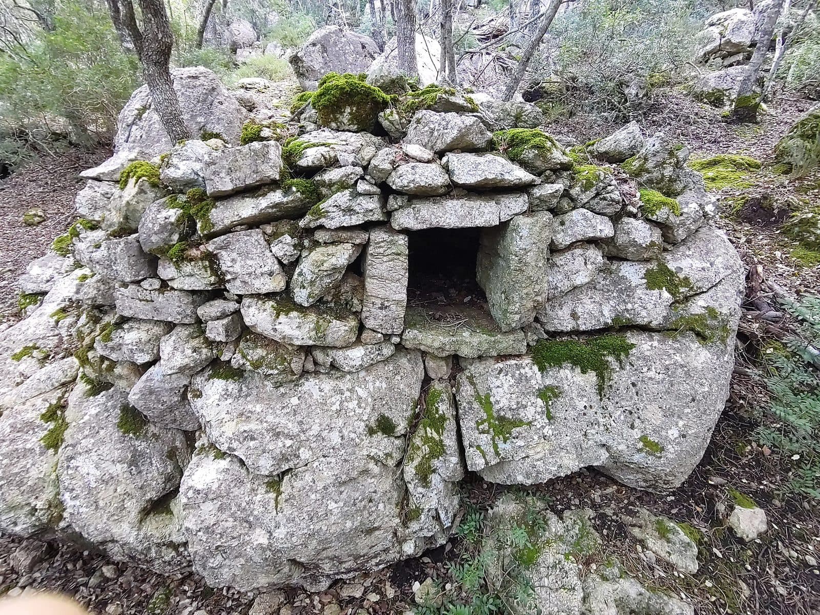
Circular, levelled areas lie among the holm oaks. At first, they appear unremarkable, but they tell of a time when the forest was a workplace. On these charcoal-burning platforms, wood was slowly carbonised into charcoal under controlled conditions. Remains of huts, ovens, wells, and other dry-stone structures show that the wooded slopes were used, maintained, and economically developed over a long period. Today’s forest landscape is therefore not solely the result of untouched nature, but also of human labour.
Forest Work and the Cultural Landscape
The surviving heritage includes charcoal-burning platforms and shelters as well as ovens and water sources. Among other features, the official area map identifies a charcoal burner’s hut, a bread oven, and several ethnological elements along the trails. These remains are not a staged exhibition. They stand where forest workers needed them and only reveal themselves while walking: stones arranged beside the path, a level area beneath the trees, or a low remnant of wall in the terrain.
As traditional woodland management declined, parts of this cultural landscape were no longer maintained regularly. At the same time, recreational pressure in the Serra de Tramuntana increased. The conservation project was created in response to both developments. It aims to limit damage caused by abandonment and intensive recreational use, restore habitats, and still allow responsible access.
Shared Responsibility on Private Land
A distinctive feature of Muntanya del Voltor is how it is organised. The estates of Can Costa, Son Moragues, Son Gual, and Son Gual Petit are considered together in matters of landscape conservation. Owners, hikers, mountain sports organisations, tour operators, and public authorities must coordinate interests that do not automatically align. This approach created an early example of collaborative landscape management in the Serra de Tramuntana.
The measures concern both nature and cultural heritage. Young holm oaks are planted, the undergrowth is regenerated with native species, and sensitive areas are protected from goats. At the same time, wells, charcoal-burning platforms, ovens, and other historic structures are secured or restored. Regulated access is therefore not a minor detail but part of the conservation plan: hiking remains possible, but it must not endanger the area’s ongoing recovery.
The Archduke’s Legacy
Another historical layer leads back to the 19th century. Archduke Ludwig Salvator of Habsburg-Lorraine, a naturalist and close observer of Mallorca, had paths and viewpoints constructed around Valldemossa. The Camí de s’Arxiduc, named after him, follows a stone-built high-level path for long stretches between Valldemossa and Deià. The Caseta de s’Arxiduc, also known as Caseta des Refugi, is likewise part of this landscape.
Muntanya del Voltor should not be equated with the entire Archduke’s Trail. Rather, it forms a protected landscape through which an important access route to the high-level path runs. Several periods therefore meet here: the working world of the charcoal burners, Ludwig Salvator’s Romantic and scientific exploration of the mountains, and modern landscape management.
What to See
The appeal of the terrain unfolds through a sequence of distinctly different landscapes. Lower down, the holm oak forest closes over the path. Higher up, pale limestone cliffs emerge, the trees thin out, and the sea appears between the trunks. Historic workplaces, small stone structures, and viewpoints lie in between. None of these features stands in isolation; the path links nature observation and cultural history into a continuous narrative.
The Holm Oak Forest
Shortly after the controlled entrance, the path climbs through an open holm oak forest. The gnarled trunks and dense canopy are among the characteristic sights of the Serra de Tramuntana. The project’s management measures are particularly visible here: the forest is to be rejuvenated, its undergrowth made more diverse again, and new growth protected from browsing.
During the ascent, rocky sections alternate with earthy forest ground. Small clearings interrupt the shade. Gradually, the trees become more widely spaced, and the first views of the northwest coast’s steep slopes open up between them. The forest is therefore not merely the approach to the viewpoints but an essential part of the visit.
Charcoal-Burning Platforms and Forest Huts
The charcoal burners’ circular platforms, known in Catalan as rotllos de sitja, are among the most important traces of cultural history. To produce charcoal, a level base had to be created where wood could be stacked, covered, and monitored over an extended period. Simple nearby shelters protected the workers while they supervised the carbonisation process.
The official area map also identifies a barraca and a ranxo de carboner. There are also ovens, wells, and other low stone structures. Many of these elements blend so unobtrusively into the limestone terrain that hurried hikers pass them by. Those who examine the shape of the platforms, wall lines, and entrances, however, will recognise a carefully organised working landscape.
Mirador de ses Puntes
At Mirador de ses Puntes, the perspective shifts from forest to open space. The viewpoint lies above a striking cliff and looks out over Can Costa, the rugged northwest coast, and the sea. To the south, the ridges of the Serra de Tramuntana rise one behind another. In clear conditions, the panorama extends far beyond the immediate slopes.
The name refers to the viewpoint’s distinctive rocky pinnacles. From the road between Valldemossa and Deià, they can be recognised as a prominent silhouette high above the slopes. At the top, the place feels less like a constructed terrace than a dramatically situated part of the mountains. Wind and exposed rock edges require greater care there than in the sheltered forest.
Mirador de Son Gual and Other Viewpoints
In addition to Mirador de ses Puntes, the official map lists Mirador de Son Gual, Mirador de na Torta, Mirador de ses Basses, and Mirador de ses Basses or the nearby terrain known as Ses Basses. Not every hike reaches all of these points. Which viewpoints are accessible depends on the approved route and the chosen hike.
The viewing directions change fundamentally along the way. In one place, the rugged coastline dominates; elsewhere, the island’s interior opens up as far as the Bay of Palma. This variation explains why the area should not be reduced to a single summit view. Muntanya del Voltor is a landscape of viewpoints with several transitions between forest, rock, and open ridge.
Caseta des Refugi
The small stone Caseta des Refugi, also known as Caseta de s’Arxiduc, recalls the era of Ludwig Salvator. It stands as a simple shelter in the mountain landscape and is not a staffed refreshment stop. Its impact comes from its location and rough masonry, not from any museum-style interior.
On longer route descriptions, the hut appears on the way to Coll de Son Gallard. From there, it is possible to join the Camí de s’Arxiduc. The Caseta therefore marks a transition: beyond the wooded protected area begins the more open high-mountain landscape, where the historic stone path crosses the Tramuntana ridges.
Camí de s’Arxiduc
The Camí de s’Arxiduc is the best-known historic trail feature in the wider area. The carefully constructed stone path follows the ridge between Valldemossa and Deià and provides long coastal views. On one documented major circular hike, it is reached only after the section through Muntanya del Voltor; the protected area and the Archduke’s Trail are therefore connected but not identical.
Above the tree line, the terrain becomes brighter and more open. The path runs through a typical karst landscape of pale limestone, low vegetation, and exposed ridges. Anyone continuing this far is no longer simply visiting Muntanya del Voltor but undertaking a full mountain hike that requires careful navigation and enough time.
Visiting Muntanya del Voltor
At the end of Carrer de les Olivers, Valldemossa gradually loses its village character. The approach initially follows a rocky path near Torrent de Son Gual. It then reaches the protected area’s access barrier, where the permit obtained in advance may be checked. Without confirmed access, visitors should not expect to be able to walk the planned circuit spontaneously.
Access and Route Choice
The permit should be requested through the protected area’s official contact channels before the day of the hike. As access conditions can change, checking the latest information immediately before the visit is recommended. Markers, closures, and notices on site take precedence over older route files. The area consists of private properties and land undergoing regeneration; shortcuts away from the recommended trails conflict with the conservation plan.
For the actual Muntanya del Voltor circuit, a documented route approximately 7,5 kilometres long is described. It takes around 3 hours and 15 minutes and is rated moderately difficult. It forms a loop from Pla des Pouet. Walking breaks, nature observation, and longer stops at the viewpoints can extend the duration considerably.
A more extensive circular hike via the Camí de s’Arxiduc is described as covering 14 kilometres, taking about 4 hours and 30 minutes, and involving 695 metres of elevation gain. These figures refer to a specific route and not to a binding standard visit. Anyone including Puig Caragolí, further ridges, or additional summits must extend the plan accordingly.
Hiking in the Protected Area
The beginning in the forest may feel gentle, but the path climbs steadily. Rocky ground, roots, and uneven limestone require attention. Exposed terrain is added at the viewpoints. The challenge comes less from technical climbing sections than from the sustained ascent and the length of the chosen circuit.
The regulated number of visitors distinguishes the area from freely accessible hiking trails around Valldemossa. Nevertheless, there is no reliably documented time when every trail is empty. More important than searching for a supposed secret hour is planning that matches the available daylight. Enough time must remain for the circuit so that the return journey does not take place under pressure.
Season and Weather
Spring and autumn are recommended for the large Archduke’s Trail circuit. At these times, summer heat is not the central concern, and longer ascents can often be completed more comfortably. After heavy rain, temporary streams may become audible or visible in the mountain landscape; at the same time, rocks and earthy sections become more slippery.
On the open heights, the weather can feel considerably harsher than down in Valldemossa. The forest provides temporary shade and shelter, whereas the Camí de s’Arxiduc crosses exposed ridges. Wind, clouds, and restricted visibility affect not only the panorama but also the demands on navigation and sure-footedness.
Getting There and Parking
The driving information refers to Valldemossa, not to an entrance gate in the middle of the protected area that can be reached by car. The final section begins in the village and is completed on foot. Driving to the viewpoint or Caseta des Refugi is not part of the visitor plan.
From Palma Airport
Valldemossa is 25 kilometres by road from Palma Airport. The drive takes around 30 minutes and initially follows the Ma-20, then the Ma-1110 into the Serra de Tramuntana. The closer you get to Valldemossa, the more winding and mountainous the surroundings become. From the car park in the village, continue on foot towards Carrer de les Olivers and then to the controlled entrance of Muntanya del Voltor.
From Palma
From central Palma, the route follows the Ma-1110 to Valldemossa. The drive covers 19 kilometres by road and takes around 35 minutes. This time also ends in the village and includes neither the search for parking nor the walk to the starting point. Additional time should be allowed for both, especially on busy days.
Parking and the Walk to the Entrance
Valldemossa has paid car parks; only limited roadside parking is available near the starting point. It therefore makes more sense to use a regular car park in the village than to rely on finding an empty space immediately beside the approach. The walk through the upper streets is already part of the transition from village to mountain landscape.
Even when arriving by bus, there is still a walk to the starting point. The stops around Valldemossa and on the road to Ermita de la Trinitat replace neither the access permit nor the hike into the area. Before the return journey, check whether the chosen circuit leaves enough spare time to reach the bus stop.
Bus lines to Muntanya del Voltor at a glance
| Line | Route | Departures/day | First | Last |
|---|---|---|---|---|
| 203 | Valldemossa / Deià | 268 | 06:43 | 22:38 |
From the official GTFS feeds (TIB/SFM), no real-time data. The figures cover all stops in the town; weekend and holiday services differ — check with the operator before travelling.
Getting there by bus
Ermita de la Trinitat 2 (63011) · 1.1 km as the crow flies
- 203Valldemossa / Deià · Daily
Ermita de la Trinitat 1 (63003) · 1.2 km as the crow flies
- 203Valldemossa / Deià · Daily
Ca Madò Pilla 2 (63004) · 1.4 km as the crow flies
- 203Valldemossa / Deià · Daily
Ca Madò Pilla 1 (63005) · 1.4 km as the crow flies
- 203Valldemossa / Deià · Daily
Valldemossa 2 (63001) · 1.5 km as the crow flies
- 203Valldemossa / Deià · Daily
Valldemossa 1 (63002) · 1.5 km as the crow flies
- 203Valldemossa / Deià · Daily
Son Gallard 1 (18008) · 1.8 km as the crow flies
- 203Valldemossa / Deià · Daily
Son Gallard 2 (18007) · 1.9 km as the crow flies
- 203Valldemossa / Deià · Daily
Timetable data: official GTFS feeds (TIB/EMT), no real-time — check with the operator before travelling.
Nearby Places to Visit
After the descent, Valldemossa’s paved lanes feel almost urban. Cafés, natural-stone houses, and the prominent Charterhouse provide a clear contrast to the holm oak forest and karst terrain. Those who allow enough time can combine the hike with a visit to the village without reducing either experience to a rushed photo stop.
Valldemossa
Valldemossa is best known for its former Charterhouse and the stay of Frédéric Chopin and George Sand. Its historic appearance, narrow lanes, and traditional baked goods make the village a destination independently of the mountain hike. The combination is also practical because Muntanya del Voltor is reached on foot from the upper part of the village.
A visit to the Charterhouse or a walk through the centre is better suited to the time before or after a shorter circuit through the protected area. After a major hike via the Camí de s’Arxiduc, there is usually less energy left for interiors and local history. The order should therefore depend on the hike’s length, the weather, and the available daylight.
Deià and the Northwest Coast
The historic Archduke’s Trail connects the mountain landscape of Valldemossa with the direction of Deià. Such a traverse, however, is a separate hike and not merely an extension of the protected area visit. It requires suitable route planning and a solution for the return journey.
Visitors travelling by car can leave Valldemossa afterwards along the coastal road towards Deià. The distinctive rock formations of Mirador de ses Puntes can be recognised again from a distance on this side. The change in perspective clearly shows how high the previously visited viewpoint stands above the wooded slopes.
Ermita de la Trinitat and Son Moragues
The wider landscape includes Ermita de la Trinitat and the public estate of Son Moragues. Both belong to the hiking area around Valldemossa but should not automatically be included in the same circuit. The official Muntanya del Voltor map shows how closely private properties, public land, the GR-221, and historic paths border one another here.
This is precisely why an up-to-date map is more important than assuming every visible path is open to the public. Anyone heading to further destinations after Muntanya del Voltor should check their access rules separately and respect the boundaries of the protected area.
The place it belongs to
Valldemossa in the place guidePractical Visitor Information
Muntanya del Voltor is not a viewpoint that can be reached from a car park in street shoes. Even the shorter circuit follows rocky, uneven paths and requires several hours of walking. Hiking boots or running shoes with grippy soles are advisable; trekking poles can reduce strain on stony descents.
Water, Sun, and Wind
For a guided Archduke’s Trail hike, 1,5 to 2 litres of water per person, food, headwear, and sun protection are recommended. This amount illustrates the nature of the undertaking. Part of the route through the holm oak forest lies in shade, but the trees provide no protection at viewpoints or on the high-level path.
Wind should not be underestimated. Mirador de ses Puntes and the open ridges of the Camí de s’Arxiduc are more exposed to the weather than Valldemossa. In poor visibility, the high-level path also loses some of its orientation points.
Hiking with Children
A documented family route through the area is described as a moderately difficult hike of approximately 7,5 kilometres, with around 3 hours and 15 minutes of walking time. It is not suitable for pushchairs and is not a short nature play circuit. Children should be accustomed to longer ascents, rocky terrain, and hikes lasting several hours.
The exposed viewpoints require particular attention. Wide panoramas are no substitute for constant supervision. Whether the circuit is suitable depends less on age than on fitness, sure-footedness, and mountain experience. The option of turning back should form part of the plan from the beginning.
Navigation and Conduct
Older GPS tracks may include paths that are currently closed or have been rerouted. The confirmed access permit, designated route, and on-site signs are decisive. Branches leading to caves, viewpoints, or neighbouring estates should be used only if they are explicitly open.
The restored charcoal-burning platforms, ovens, and walls are historic remains, not seating or climbing structures. Young plants and closed regeneration areas also need space. Anyone who stays on the path, takes litter away, and respects the forest’s tranquillity directly helps controlled public access and private landscape management coexist.
What Not to Expect
There is neither a conventional museum nor a fully developed nature park on site. The sights are distributed along a mountain hike, and many historic traces reveal themselves only on close inspection. Caseta des Refugi is a simple mountain hut, the charcoal-burning platforms are archaeological features, and the viewpoints lie in natural, partly exposed terrain.
This restraint is precisely what gives Muntanya del Voltor its character. The visit does not consist of a series of stops to be checked off quickly. It follows the gradual transition from village to forest, from woodland labour to nature conservation, and from shaded slopes to open coastal views.
Local insider tips
Look for Circular Clearings
The charcoal-burning platforms often look like ordinary clearings. Their levelled, roughly circular ground and nearby wall remains are the main clues. Wood was carbonised into charcoal here; for a long time, the forest was a workplace.
Do Not Skip Ses Puntes
Mirador de ses Puntes offers views beyond the northwest coast. Depending on visibility, the panorama also extends across layered Tramuntana ridges and towards the island’s interior. Care is needed near the edge because of the exposed terrain.
Distinguish the Protected Area Clearly
Muntanya del Voltor and Camí de s’Arxiduc are not the same. The route through the protected area can lead to the historic high-level path. Anyone continuing there turns the visit into a considerably longer and more exposed mountain hike.
Do Not Just Pass Through the Forest
In the holm oak forest, young plantings, protected vegetation areas, and regenerating undergrowth reveal the actual conservation work. The forest is therefore more than a shaded approach to the viewpoints.
Explore Valldemossa Afterwards
After the shorter circuit, the mountain visit can easily be combined with Valldemossa’s lanes and Charterhouse. After a large loop via the Archduke’s Trail, however, the village walk should not be scheduled too close to the return journey.