
Mirador de ses Puntes near Valldemossa
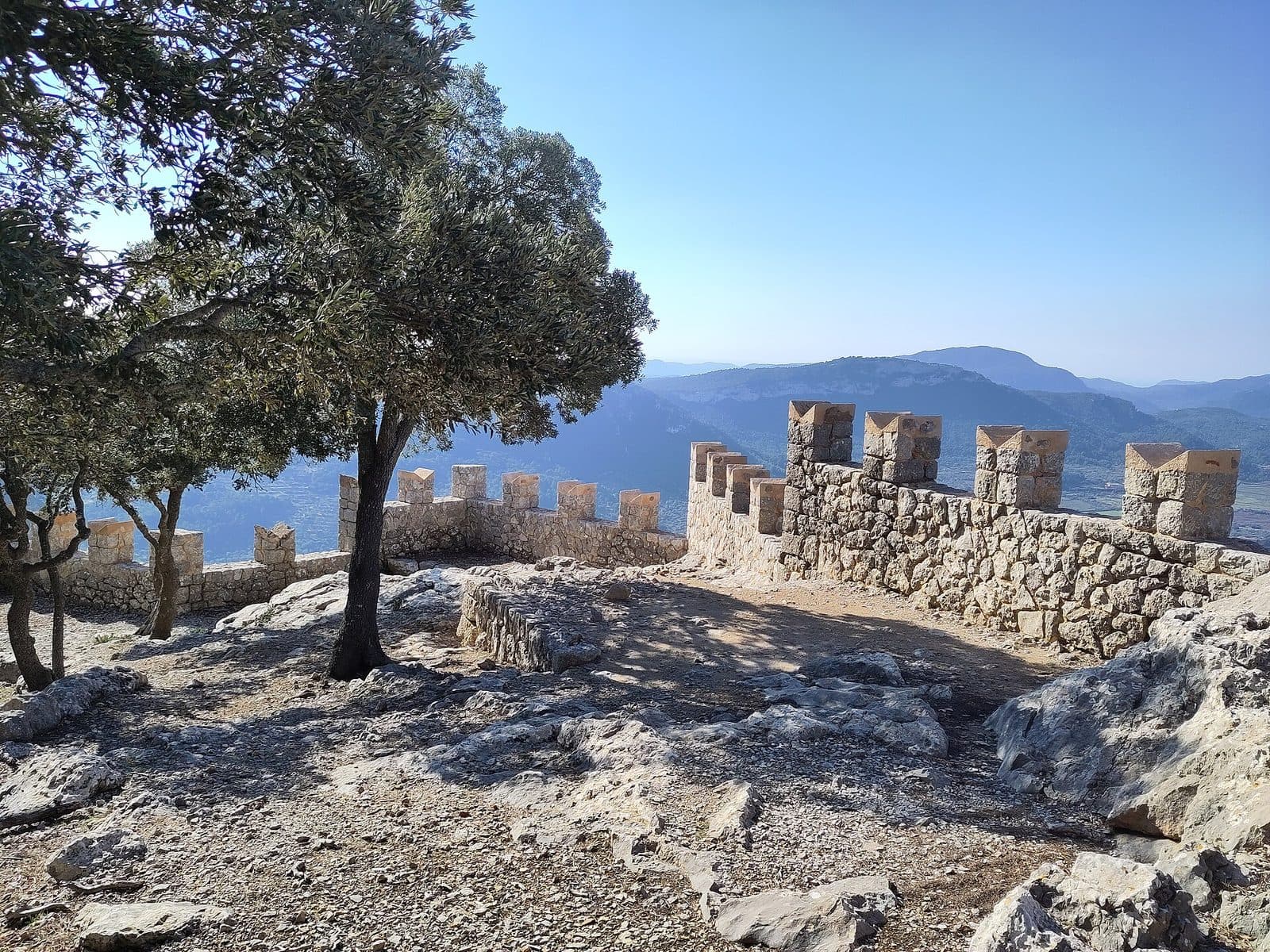

Mirador de ses Puntes is one of those viewpoints in Mallorca that cannot be appreciated on a drive-by visit. It lies above Valldemossa in the Serra de Tramuntana mountains and is reached on foot. The route itself is part of the experience: it leads out of the village, climbs through rocky terrain, and passes through a landscape shaped by holm oak forest, old paths, and dry-stone walls.
At the top, views open up in several directions. You can see the mountains around Valldemossa, the coast, and the island’s interior; in clear conditions, the panorama extends as far as Palma. Yet the view is only part of its distinctive character: the Mirador is also a historically designed site whose battlement-like wall gave it the popular name “ses Puntes,” the points.
A visit is especially worthwhile for hikers who want to combine scenery with cultural history. The viewpoint is not beside a road and is not a quick photo stop. Prior authorization is required for access through Muntanya del Voltor. Those who set out prepared, however, will experience the Mirador as the destination of a varied mountain hike rather than simply a platform with distant views.
Its proximity to Valldemossa makes the hike particularly appealing. Below are the village’s stone-paved lanes, while farther up begins a quieter world of forest tracks, mountain paths, and historic viewing structures. The transition happens on foot and is clearly noticeable: with every section, the village recedes farther into the background as the coast and mountains take over the view.
History and significance
Mirador de ses Puntes is associated with Archduke Ludwig Salvator, whose legacy remains visible along Mallorca’s northwest coast in paths, viewpoints, and small structures. He commissioned the viewpoint. In specialist inventories, the structure is referred to as Mirador de Can Costa; “Mirador de ses Puntes” is the commonly used name and refers to the wall’s striking design.
Archduke Ludwig Salvator
At Mirador de ses Puntes, the connection with Ludwig Salvator is particularly evident: he commissioned the viewpoint, a historic viewing structure in the mountain landscape between Valldemossa and Deià. One source places it near the beginning of the well-known Camí de s’Arxiduc. The wall, path, and standing area create a fixed place from which the coast, mountains, and island interior can be viewed.
Mirador de Can Costa
Mirador de Can Costa is popularly known as Mirador de ses Puntes. The second name comes from the battlement-like projections on the wall. They resemble a medieval fortification, although the Mirador is neither a castle nor a defensive structure. This playful reference is precisely what makes the site distinctive and helps distinguish it from the other viewpoints in the surrounding area.
Today, the Mirador lies in an area with regulated access. A large portion of the relevant hiking routes crosses Muntanya del Voltor, a private estate and part of a specially protected natural area. The permit requirement is therefore more than an organizational detail; it shapes the site’s present-day role. The historic viewpoint is visited as the destination of a controlled hike through a sensitive mountain landscape.
Old paths and a dry-stone landscape
The surroundings also preserve part of the Tramuntana’s traditional cultural landscape. Dry-stone walls and other traces of former woodland and mountain-based activities can be found in the forests and along the paths. The wider context extends to Ruta de Pedra en Sec, whose name refers to the many walls, terraces, huts, and other stone structures built without mortar along the route.
Several historical layers therefore meet at the Mirador: traditional ways of working with stone and terrain, together with the Archduke’s viewing structure, have shaped the landscape. Today’s access rules, in turn, seek to reconcile nature conservation, private ownership, and visitors. Those who reach the Mirador are not merely standing before a beautiful view but at a place where these three dimensions directly overlap.
What to see
Even before the full panorama unfolds, the wall’s jagged silhouette catches the eye. This is the detail that gave the viewpoint its name. Unlike a natural rocky outcrop, it is immediately apparent that this viewing point was deliberately designed: an architectural edge marks the location, while the open mountain landscape forms the actual panorama.
The battlement-like wall
The points placed on top of the wall resemble the battlements of a medieval fortification. This exact shape led to the name “ses Puntes.” The Mirador had no defensive function but is a viewing structure with a distinctive wall.
Seen up close, it becomes clear why the popular name prevailed over the more formal designation Mirador de Can Costa. The points are easy to recognize and give the structure its own silhouette. Anyone who looks up only for the panorama will miss the most important architectural detail. It is worth taking a brief look back at the wall as well as looking out across it.
The coastal view
One side of the panorama belongs to Mallorca’s northwest coast. The Mirador lies in the mountain landscape above Valldemossa, so the sea and coastal terrain appear not as they would from a beachfront promenade but within the wider setting of the Tramuntana. Wooded slopes, rocky contours, and the open sea form successive layers.
Visibility depends heavily on the weather. In clear air, the coastline and distant landscapes emerge more distinctly; clouds and haze can greatly restrict the range of the view. This does not diminish the viewpoint’s scenic character, but its long-distance panorama is not guaranteed at all times. Before setting out, the visibility forecast is therefore at least as important as the precipitation forecast alone.
The view across the island’s interior
The Mirador does not face only the sea. Its mountain position also offers views across the island’s interior. This contrast is exactly what makes the location interesting: the coast lies on one side, while on the other Mallorca opens toward more distant plains and settlements.
In exceptionally clear conditions, the view extends as far as Palma. This distant perspective highlights Valldemossa’s location at the transition between the mountains and the more southerly part of the island. Palma does not appear as a nearby cityscape but as a distant reference point within a much larger landscape. Haze can make it disappear completely; clear weather is essential for this part of the view.
Holm oak forest and mountain paths
The route to the Mirador passes through a landscape that offers more than open views from the heights. Holm oak forest is one of the defining elements of the surroundings. Beneath the trees, the character of the hike changes: distant views temporarily recede while rocky ground, walls, and the lines of old paths come to the fore.
Camí de s’Arxiduc runs through the wider area, linking Valldemossa and Deià through the mountains. Mirador de ses Puntes is considered part of, or near the beginning of, this historic path network. As a result, the viewpoint feels less like a chance stopping place and more like a deliberately positioned moment along a route that repeatedly alternates between forest, high-level paths, and open panoramas.
Pla des Pouet, Talaia Vella, and Son Gallard
A documented circular hike connects the Mirador with Pla des Pouet, Talaia Vella, and Son Gallard. The ascent can lead via Pla des Pouet; for the return, a variation via Talaia Vella and the mountain refuge of Son Gallard is described. These names refer to separate points along the route and should not be confused with the Mirador itself when navigating.
Pla des Pouet forms a distinctive section of the path network above Valldemossa. Talaia Vella adds another mountain location to the hike, while Son Gallard recalls the Archduke’s historic structures. Together, they create a hike on which Mirador de ses Puntes is a highlight but not the only landmark. Depending on the route chosen, distance, elevation profile, and difficulty vary considerably.
Visiting the viewpoint
One described approach begins at the end of Ses Oliveres street in Valldemossa. A rocky path initially follows Torrent de Son Gual. It then reaches the controlled entrance to Muntanya del Voltor. At the checkpoint there, the required permit is verified, and route information may also be provided.
Permit for Muntanya del Voltor
A permit must be requested in advance to reach the Mirador through Muntanya del Voltor. Authorization should be obtained in good time from the responsible organization, Muntanya del Voltor, and provides access to the long bridle-path circuit. Without valid authorization, the hike may end at a locked gate.
This belongs at the beginning of your planning, not the end. The Mirador is not a freely accessible roadside viewpoint suitable for a spontaneous short detour. A digital hiking route does not replace the permit either. Because signposts and official trail markers from Valldemossa may not be consistently reliable, you should also carry prepared route guidance.
Approach from Valldemossa
The walk from Valldemossa to the viewpoint takes slightly more than an hour. This indicates the direct time needed to reach the Mirador, not the duration of a complete circular hike. Breaks, route-finding, photo stops, and the chosen return route will extend the outing accordingly.
One extensively documented circular route covering several points is 13 kilometers long, with 475 meters of ascent and descent respectively. Other published variations are rated considerably more demanding and have different route profiles. The main conclusion is that not every hike named Mirador de ses Puntes is identical. Before setting out, check the course and return section of the specific route you have chosen.
Time at the viewpoint
The Mirador itself does not require a lengthy visit following a set circuit. Time can be spent taking in the different viewing directions, examining the battlement-like masonry, and resting after the ascent. Anyone who simply takes a photo and immediately turns back will miss the transition between coastal views, mountain scenery, and the island’s interior.
Do not calculate the entire excursion based solely on the walking time to the viewpoint. The outward and return journeys already take considerably longer than the stay at the top; a circular route via additional points becomes a substantial hike in its own right. Planning an early start is also sensible because a late departure cannot be offset by taking a shortcut by car.
Weather and visibility
Clear conditions are especially valuable for a visit. The view can then extend across the sea and inland toward Palma. Low clouds or haze restrict precisely the distant views for which the Mirador is known. Forecasts for cloud cover and visibility therefore deserve careful attention.
No reliably quiet time of day has been documented. Regulated access affects visits more strongly here than at a freely accessible viewpoint in any case. Anyone hoping to avoid crowds should ask about current conditions when applying for the permit and allow enough flexibility rather than relying on a particular time as a guarantee.
Specific opening hours and admission information have not been reliably documented. Because access rules can change and the permit is essential, current conditions should be checked directly with Muntanya del Voltor immediately before your visit.
Getting there and parking
The stated driving routes end in Valldemossa, not directly at Mirador de ses Puntes. The viewpoint lies in mountainous terrain and is reached on foot for the final section. A navigation destination at the Mirador must therefore not be mistaken for a drivable access road.
From Palma Airport
From Palma Airport, first take the Ma-20 and then the Ma-1110 to Valldemossa. The road distance is 25 kilometers, and the drive takes around 30 minutes. This time applies only as far as Valldemossa. From there, the remainder must be planned as a hike; for one described route, the trail begins at the end of Ses Oliveres street.
Allow time between arriving in the village and starting the hike for orientation and preparing your backpack. The permit must already have been arranged. Anyone who waits until reaching the trailhead to clarify access risks being unable to proceed at the controlled entrance.
From central Palma
From central Palma, the route follows the Ma-1110. Valldemossa is 19 road kilometers away, and the drive takes around 35 minutes. Here too, the driving time ends in the village, not at the viewpoint. The final section continues on foot into Muntanya del Voltor or along the chosen route above Valldemossa.
The shorter distance compared with the airport route does not automatically mean a shorter driving time. The starting point, city traffic, and the course of the Ma-1110 all affect the journey. For planning the day, the main consideration is that the road trip is followed by an ascent of more than an hour to the Mirador.
Parking and public transport
There is no documented road access to the Mirador itself. Vehicles must therefore remain in Valldemossa; current parking conditions should be checked before departure.
There are bus stops in the area, but arriving by public transport does not take you directly to the viewpoint either. The bus stop, the beginning of the hike, and the authorized access must be planned as separate stages. The return is particularly important: a longer circular route must not be timed as though the Mirador were followed only by a short walk to a bus stop.
Bus lines to Mirador de ses Puntes at a glance
| Line | Route | Departures/day | First | Last |
|---|---|---|---|---|
| 203 | Valldemossa / Deià | 268 | 06:43 | 22:38 |
From the official GTFS feeds (TIB/SFM), no real-time data. The figures cover all stops in the town; weekend and holiday services differ — check with the operator before travelling.
Getting there by bus
Ermita de la Trinitat 1 (63003) · 0.6 km as the crow flies
- 203Valldemossa / Deià · Daily
Ermita de la Trinitat 2 (63011) · 0.7 km as the crow flies
- 203Valldemossa / Deià · Daily
Ca Madò Pilla 2 (63004) · 1.0 km as the crow flies
- 203Valldemossa / Deià · Daily
Ca Madò Pilla 1 (63005) · 1.1 km as the crow flies
- 203Valldemossa / Deià · Daily
Son Gallard 1 (18008) · 1.8 km as the crow flies
- 203Valldemossa / Deià · Daily
Valldemossa 2 (63001) · 1.9 km as the crow flies
- 203Valldemossa / Deià · Daily
Son Gallard 2 (18007) · 1.9 km as the crow flies
- 203Valldemossa / Deià · Daily
Valldemossa 1 (63002) · 1.9 km as the crow flies
- 203Valldemossa / Deià · Daily
Timetable data: official GTFS feeds (TIB/EMT), no real-time — check with the operator before travelling.
Nearby places
After the descent, Valldemossa feels almost like a counterpoint to the open mountain landscape. Instead of distant views, narrow lanes, stone façades, and the compact village scene shape the impression. This is precisely why the Mirador combines well with a walk through the village: each reveals a different side of the same Tramuntana landscape.
Valldemossa
Valldemossa works both as the starting point and the conclusion of the hike. Anyone who explores the village first should leave enough time for the approach, the viewpoint, and the return. Alternatively, the historic streets can be included in a walk after the hike without a major change of location or adding another drive to the hiking day.
The contrast also helps place the Mirador in context. Below, Valldemossa represents the village’s built cultural landscape; above, dry-stone walls, forest tracks, and viewing structures reveal a more extensive form of human landscape design. The Mirador is therefore not an attraction isolated from the village but part of the historic path network above Valldemossa.
Camí de s’Arxiduc
For experienced and properly prepared hikers, Camí de s’Arxiduc provides the most important wider context. The mountain path runs between Valldemossa and Deià, passing through holm oak forest and across scenic heights. Mirador de ses Puntes is associated with its initial section.
Such a connection should not be extended spontaneously. Camí de s’Arxiduc is a mountain route, not a walking path between two village centers. Access, route, and return plans must be established in advance. Anyone who only wants to visit the Mirador is better served by a clearly planned out-and-back or circular route than by trying to combine several hike descriptions along the way.
Pla des Pouet and Talaia Vella
Pla des Pouet and Talaia Vella are the most obvious additions within a documented circuit. They extend the visit through additional hiking sections rather than extra driving. Son Gallard can also be included on one described descent route.
This combination is especially suitable for visitors who see the viewpoint as part of a full hiking day. Those with limited time or little mountain experience, however, should not choose a longer circuit solely because several destinations are available. The essential point remains that the route, permit, and available daylight must all fit together.
The place it belongs to
Valldemossa in the place guidePractical information for your visit
The first practical point lies in the nature of the route: reaching the Mirador requires a hike. Rocky ground is already documented along the described approach beside Torrent de Son Gual. Footwear with good grip is therefore more appropriate than lightweight city or beach shoes. A hiking map or offline navigation helps where markers are absent or unclear.
Do not set out without a permit
Authorization for Muntanya del Voltor is not an optional recommendation. There is a checkpoint at the entrance, and without a valid permit, a locked gate may bring the hike to an end. Before the walk, check the authorization, permitted route, and current guidance together.
Older hike descriptions should also be viewed critically. Access conditions and route guidance can change. The current rules of the responsible organization are authoritative, not the fact that a route was once completed without problems.
Take the weather seriously
The value of the viewpoint depends more heavily on visibility than at a building with indoor spaces. In haze or low cloud, the distant view as far as Palma may disappear. At the same time, this remains a mountain hike, and conditions should not be judged solely by the weather below in Valldemossa. Holm oaks offer temporary natural shelter on forested sections, but this does not mean the entire route is shaded.
With children
For families, the route rather than the viewpoint itself is the crucial consideration. A rocky approach, more than an hour of walking to the destination, and potentially a longer circular route require sure-footedness, stamina, and reliable behavior in mountain terrain. The hike should therefore be chosen according to the children’s experience and not mistaken for a short outing to a platform.
Shorter and longer variations must not be confused. One documented circuit covers 13 kilometers with 475 meters of both ascent and descent; other routes to the Mirador are considered even more demanding. Families should decide on a clearly defined route in advance and leave enough reserves for breaks and the return.
What not to expect
Mirador de ses Puntes is not a viewpoint with documented road access. The focus is on the historic masonry, the mountain landscape, and the view. A visit therefore does not follow the pattern of stopping, getting out, taking a photograph, and driving on.
Nor are the battlements the remains of a medieval castle. They are the characteristic design feature of a viewing structure commissioned by Archduke Ludwig Salvator. Understanding this distinction makes the site easier to interpret: the wall defends nothing but instead marks a place from which Mallorca was intended to be viewed.
Local insider tips
Do not miss the points
Do not look only over the wall into the distance: the battlement-like projections gave the Mirador its popular name, “ses Puntes.” They resemble a fortification but belong to a historic viewing structure.
Wait for clear visibility
In clear air, the view extends not only to the coast and across the island’s interior but as far as Palma. Before setting out, it is therefore worth checking cloud cover and visibility; haze can obscure this distant view in particular.
Arrange the permit first
Access through Muntanya del Voltor is controlled. Authorization should be requested before planning the rest of the hike because, without a valid permit, the route may end at a locked gate.
Do not mix routes
Routes of different lengths and difficulty levels circulate under the same hike name. One documented circuit passes through Pla des Pouet, Talaia Vella, and Son Gallard. Choose a route in advance and follow that exact route.
Read the forest landscape
The holm oak forest is not merely the section before the viewpoint. Dry-stone walls and traces of former woodland activities make the approach part of the historic landscape experience around Valldemossa.