
Necròpolis de Son Sunyer: Bronze Age burial caves near S’Arenal
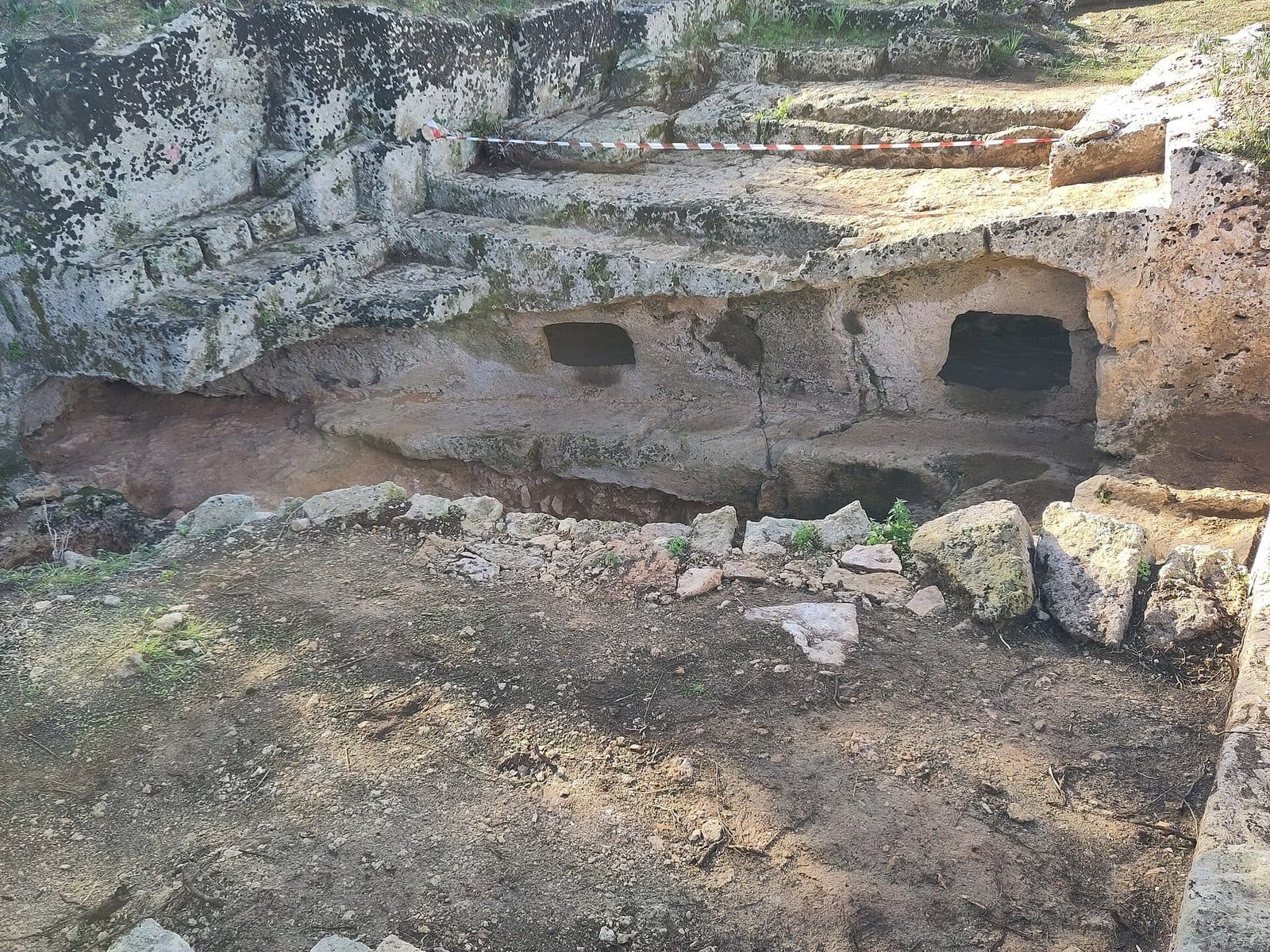

Not far from S’Arenal, Necròpolis de Son Sunyer offers a glimpse into an era easily overlooked in Mallorca’s tourist-oriented south. Here lie eight artificial burial caves carved into the rock during the Bronze Age. They form one of the larger groups of their kind on the island and reveal the funerary rituals of the Naviform period, long before the Talayotic culture shaped Mallorca.
The first impression, however, is not of a fully preserved underground city of the dead. Medieval quarrying and later interventions damaged a large part of the site. These very fractures make the place archaeologically instructive: where caves were cut through, their internal structure can sometimes be read like an exposed cross-section. Corridor, burial chamber, central depression, and side niches thus become more than technical terms—they are recognizable elements of deliberately planned ritual architecture.
The site is particularly rewarding for people who want to understand Mallorca beyond its major museums and restored monuments. Son Sunyer is not a staged visitor attraction. The necropolis demands careful attention, a respectful view of its damaged structures, and some imagination. In return, it shows with particular clarity how deliberately prehistoric communities created spaces for their dead.
The site’s identity is important to establish clearly: Son Sunyer lies near Es Pil·larí and S’Arenal in southern Mallorca.
History and significance
When the caves of Son Sunyer were created, the area around today’s Prat de Sant Jordi was a fertile marshland. Settlements stood along its edges, and their inhabitants used the necropolis as a shared burial place. The landscape southeast of Palma looked fundamentally different from today’s surroundings of roads, residential areas, airport, and holiday resorts. The burial caves are a reminder that this part of the island was already inhabited and culturally shaped in prehistoric times.
The Naviform period
The core of the site is assigned to the Naviform period of the Bronze Age, dated from 1600 to 1200 BC. The term refers to a phase preceding the Talayotic culture. At Son Sunyer, this era is represented not by above-ground towers or monumental stone structures but by artificially created underground spaces for burials.
The caves were not natural cavities enlarged at random. Their recurring pattern of entrance, corridor, chamber, central pit, and side compartments shows that the site followed an established spatial and ritual concept. Anyone entering moved from the open landscape through a narrowed passage into an interior space created specifically for the dead. The architecture followed a spatial and ritual concept.
Together with the artificial burial caves of Alzinaret near Cala Sant Vicenç, Son Sunyer ranks among the important groups of this kind on Mallorca. The comparison concerns their archaeological classification, not their state of preservation: while other necropolises have retained their spatial forms more completely, large parts of Son Sunyer are severely damaged. Its value therefore lies both in the surviving caves and in the visible cross-sections of the destroyed sections.
Transition to the Talayotic period
Not every part of the necropolis belongs to the same phase. Cave 6 is assigned to the Talayotic period and lies apart from the main complex. Son Sunyer therefore shows that the burial ground was not created for a single brief moment. Instead, different prehistoric traditions can be identified within the same site.
This chronological sequence is particularly important. The necropolis is not a uniform ensemble built all at once, but an archaeological site where changes in burial culture left their mark. Most of it represents the pre-Talayotic concept of artificial burial chambers; Cave 6 adds a later element.
Quarrying and destruction
The most serious damage resulted from the exploitation of the local sandstone. Quarries were established within the necropolis during the Middle Ages. The work cut into almost every cave or destroyed parts of their walls and ceilings. What was a useful raw material to the quarry workers of the time is now recognized as part of a prehistoric burial ground.
This intervention explains why Son Sunyer is more difficult to interpret at first glance than a fully preserved cave complex. At the same time, it produced an unusual perspective: some spaces were cut open in a way that made their shape visible from the side. The loss remains severe, but the exposed profiles help visitors understand the internal structure. According to documentation from 2022, archaeological investigations and restoration work were still under way. Son Sunyer is therefore not merely a historic ruin but also a place of continuing research and conservation.
What to see
Eight artificial burial caves are distributed across the site. They do not form an even row, nor are they all equally well preserved. To understand the complex, it helps to examine their grouping first and then look for the recurring architectural elements. The character of the necropolis lies not in the size of any individual space but in the relationship between entrance, chamber, and internal features.
The main complex: Caves 1 to 5 and 7
The central group consists of Caves 1 to 5 and Cave 7. They lie close together as the main complex. Because of the damage, individual sections now resemble rocky hollows, partially exposed chambers, or open profiles rather than fully enclosed caves.
When looking at them, it is worth searching for more than dark entrances. Much of the archaeological information lies in floor lines, smoothed rock surfaces, remnants of partitions, and transitions between narrower and wider areas. Although the medieval quarries removed original boundaries, in some places they also exposed the structure in cross-section.
The caves were burial spaces, not dwellings. Hearths, domestic room sequences, or comfortable furnishings should not be expected here. The layout served a ritual purpose. This context changes how the structures are viewed: a narrow passage is not merely an entrance but part of the route into the burial space, while a depression in the floor belongs to the chamber’s internal organization.
Cave 6
Cave 6 lies apart from the main group and is assigned to the Talayotic period. It is therefore particularly informative for understanding the chronology of the entire necropolis. While the main complex predominantly represents the pre-Talayotic tradition of artificial burial caves, this separate space points to a later phase.
Its physical separation should be noted deliberately during a visit. Son Sunyer does not consist solely of a compact cluster of openings placed close together. The detached position of individual caves forms part of the archaeological evidence and makes clear that the necropolis extended across a larger area. Anyone who looks only at the main complex will therefore miss an essential part of its development.
Cave 8
Cave 8 is also located apart from the central group. Its position helps reveal the extent of the burial ground. It also serves as a reminder that the structures visible today were not connected by corridors like rooms in a building. Each cave formed a separate unit cut into the rock within a shared necropolis.
When finding your way around, the numbering should not be mistaken for a chronological sequence. It primarily serves to distinguish the individual archaeological features. For visitors, it is more important to read the main complex and the two separately situated caves as parts of a larger whole.
Corridor and burial chamber
The basic concept of the pre-Talayotic caves can be understood through the transition from corridor to chamber. The corridor leads into the actual burial space and creates a clear division between the outside world and the tomb. Even where ceilings or side walls are missing, differences in width and the orientation of worked rock surfaces can indicate this sequence of spaces.
The chamber was the center of the structure. It was carved artificially from the sandstone rather than simply installed in an existing natural cave. This is one of Son Sunyer’s defining features: Bronze Age communities shaped the rock according to their idea of how a burial space should be designed.
Central pit and side niches
The characteristic layout includes a central depression and side compartments or niches. This arrangement gave the chamber an internal order. The surfaces were not used arbitrarily but divided into distinct areas. Because of the destruction, such features are not equally clear in every cave today.
For this reason, it is worth examining the rock slowly. Hollows, ledges, and recessed sections along the sides may be remnants of the original design. They should not be stepped on or used as seats. The archaeological value often lies in inconspicuous working marks whose significance may be difficult to recognize without direct comparison.
The exposed cave profiles
The most unusual visual feature at Son Sunyer is not an individual decorative element but the cross-section of some caves exposed by quarrying. Where a wall or part of a chamber was removed, the formerly hidden shape of the space can be viewed from outside. In places, the site resembles an opened model of prehistoric tomb architecture.
This perspective does not replace what has been lost. It does, however, explain why a severely damaged necropolis can remain so instructive. By following a cut edge, visitors can better understand how deeply a space extended into the rock, how the entrance and chamber related to each other, and which parts later disappeared. Son Sunyer therefore tells two stories at once: that of Bronze Age burial culture and that of the medieval reshaping of the site.
Visiting the site
Son Sunyer does not reveal itself in a single spectacular view. The first step is orientation: where is the main group, where are the separate caves, and which rock forms are prehistoric? Only then do the individual parts of the spaces become legible. A good visit therefore begins with the grouped Caves 1 to 5 and 7 before turning to the separate Caves 6 and 8.
Confirm access beforehand
A description of the site from 2022 characterizes access as generally easy but explicitly states that permission is required to enter the property. Because archaeological and restoration work was also documented, current access conditions should be checked before traveling. Barriers or restrictions protect a sensitive archaeological site and must always be respected.
No reliably current opening hours or admission information have been recorded. It is therefore advisable to confirm before visiting whether the necropolis is accessible and which conditions apply. Entering the property spontaneously without clarification is not recommended.
A site that rewards close observation
A visit is based on comparison. At first, a damaged rock structure may be almost indistinguishable from traces left by the quarry. Once the corridor, chamber, floor depression, and side niches are recognized as a recurring pattern, however, the forms begin to make sense. A side section can then explain more than a fully preserved but dark interior.
To understand the site, it is useful to distinguish between original cave architecture and later quarry edges. More smoothly worked surfaces, recognizable spatial axes, and regularly formed depressions belong to the prehistoric design; large cuts and missing ceilings are often connected with quarrying. Not every edge can be interpreted with certainty without specialist knowledge, so restraint is better than climbing on presumed architectural elements.
How long to spend and what to expect
A fixed visiting time would be of little help at Son Sunyer. The amount of time worth allowing depends mainly on whether you want only an overview or plan to compare the forms of the individual caves. Anyone who becomes familiar with the layout and also considers the separate caves will need considerably more time than for a brief photo stop.
Large visitor numbers or reliably quieter times are not documented. Confirming access in advance is therefore more important than choosing a particular time of day. Archaeological work, property rules, and possible protective measures may affect the visit more than the usual rhythm of a tourist attraction.
Getting there and parking
Necròpolis de Son Sunyer is not on the beachfront promenade of S’Arenal but inland near Es Pil·larí and Son Sunyer, east of the airport. Directions to S’Arenal therefore cover only the broader journey. For the final section, select the necropolis or the Son Sunyer area specifically and also verify whether access to the property is permitted.
From Palma Airport
The road distance from Palma Airport to S’Arenal is 9 kilometers, and the journey takes around 12 minutes. These figures end in S’Arenal, not directly at the burial caves. From there, the final section leads inland again toward Es Pil·larí and Son Sunyer. No specific road number for the airport route is given in the available directions.
The short journey time can obscure the fact that the necropolis is not a conventional destination with a clearly visible main entrance. Before setting out, confirm not only the map location but also the currently permitted access. A nearby track or the edge of a property is not an invitation to enter an archaeological site.
From Palma
From central Palma, the route follows the Ma-19 toward S’Arenal. The road distance is 15 kilometers, and the journey takes around 23 minutes. Here too, the distance and travel time refer specifically to S’Arenal. The onward route to the necropolis then leads into the area near Es Pil·larí and Son Sunyer.
Because the caves lie on land for which permission requirements have been documented, vehicles should be left only where parking is clearly permitted. Access roads to fields, working tracks, and property entrances must remain clear. No designated visitor parking area is mentioned in the available information, so visitors should not assume that they can park directly beside the caves.
By bus
The stops s’Hort de S’Àguila and Can Reviu are located in the wider area. They provide reference points for traveling to the district but do not replace planning for the final part of the route. In particular, confirm which stop provides access to the currently permitted approach. The archaeological site is not a fully developed museum complex where the route from the bus automatically leads to an entrance.
Anyone arriving by public transport should also allow sufficient time for the walk and for the possibility of turning back if the property is inaccessible. Barriers must not be bypassed, even if reaching the site has already taken considerable time.
Getting there by bus
431-s'Hort de S'Àguila · 0.7 km as the crow flies
- 31Sant Jordi - Sindicat · 08:00–08:00 · Daily
413-s'Hort de s'Àguila · 0.7 km as the crow flies
- 31Sant Jordi - Sindicat · 08:00–08:00 · Daily
402-Can Reviu · 0.9 km as the crow flies
- 31Sant Jordi - Sindicat · 08:00–08:00 · Daily
396-Can Reviu · 0.9 km as the crow flies
- 31Sant Jordi - Sindicat · 08:00–08:00 · Daily
952-es Pil·larí · 1.0 km as the crow flies
- 31Sant Jordi - Sindicat · 08:00–08:00 · Daily
- 32s'Arenal - Sindicat · 08:00–08:00 · Daily
300-Escola de s'Aranjassa · 1.0 km as the crow flies
- 31Sant Jordi - Sindicat · 08:00–08:00 · Daily
947-es Pil·larí · 1.0 km as the crow flies
- 31Sant Jordi - Sindicat · 08:00–08:00 · Daily
- 32s'Arenal - Sindicat · 08:00–08:00 · Daily
281-Can Xoroll · 1.0 km as the crow flies
- 31Sant Jordi - Sindicat · 08:00–08:00 · Daily
- 32s'Arenal - Sindicat · 08:00–08:00 · Daily
399-Escola de s'Aranjassa · 1.0 km as the crow flies
- 31Sant Jordi - Sindicat · 08:00–08:00 · Daily
302-Can Xoroll · 1.0 km as the crow flies
- 31Sant Jordi - Sindicat · 08:00–08:00 · Daily
- 32s'Arenal - Sindicat · 08:00–08:00 · Daily
196-Son Perera · 1.2 km as the crow flies
- 31Sant Jordi - Sindicat · 08:00–08:00 · Daily
409-Son Perera · 1.2 km as the crow flies
- 31Sant Jordi - Sindicat · 08:00–08:00 · Daily
Timetable data: official GTFS feeds (TIB/EMT), no real-time — check with the operator before travelling.
Nearby places
Few places on Mallorca show a stronger contrast between the present and prehistory than the surroundings of Son Sunyer. Along the coast, S’Arenal and Playa de Palma extend through an area of hotels, restaurants, promenades, and intensive beach tourism. Inland, the necropolis recalls a landscape already used during the Bronze Age, when it bordered the fertile wetlands of Prat de Sant Jordi.
S’Arenal and Playa de Palma
S’Arenal is a convenient base because it has good connections to Palma and the airport. A visit to the necropolis can be combined with a coastal walk or time at the beach. Son Sunyer should not, however, be treated as a minor attraction that can be added spontaneously along the way: its access conditions require separate confirmation.
Moving from the busy coast to a prehistoric burial ground changes how the region is perceived. Today’s continuous strip of development is relatively young, while the caves tell of a far older use of the inland landscape. Experiencing both sides in one day reveals how many historical layers lie beneath the modern image of the Bay of Palma.
Es Pil·larí and Prat de Sant Jordi
Archaeologically, Son Sunyer belongs more closely to the area of Es Pil·larí and Prat de Sant Jordi than to the beach landscape of S’Arenal. In prehistoric times, the Prat was a fertile marsh, with settlements developing along its edges. The necropolis therefore did not stand in an isolated and meaningless void but within a landscape inhabited and used by people.
This context helps explain the choice of location without inventing unsupported sightlines or routes. The burial caves belonged to communities in the surrounding area. They formed part of a cultural landscape in which settlements, economically useful land, and burial grounds occupied distinct and deliberately chosen areas.
Palma for additional cultural context
Palma is easily reached from S’Arenal via the Ma-19. After visiting Son Sunyer, the capital offers a broader historical context for Mallorca. Visitors seeking more detailed interpretation or a museum setting are more likely to find suitable cultural institutions in Palma.
Even when combining these places, Son Sunyer should not be confused with other necropolises on the island. Similar names are common on Mallorca but by no means refer to the same place or archaeological tradition.
The place it belongs to
S'Arenal (L'Arenal) in the place guidePractical information for your visit
Son Sunyer is a sensitive archaeological site, not a reconstructed open-air museum. Proper preparation therefore depends less on a long equipment list than on three basic principles: confirm access, do not step on the rock structures, and expect a fragmentarily preserved site. Anyone who accepts these conditions can learn a surprising amount from the damaged caves.
Sturdy footwear and careful walking
Worked rock, open depressions, and broken edges require attention. Sturdy footwear is advisable even though access has generally been described as easy. “Easy” does not mean that every surface is level or suitable for careless walking. The central pit and remnants of side features in particular should not be mistaken for ordinary uneven ground.
Climbing onto edges, chamber remains, or niches endangers both visitors and the archaeological fabric. Many informative traces are inconspicuous. Even small alterations to a worked rock surface can make later interpretation more difficult.
Visiting with children
For children interested in history, the site can be engaging if adults explain it as “cut-open” tomb architecture: where did the entrance run, where did the chamber begin, and which parts are missing today? The necropolis is not, however, an open play area. Depressions, damaged rock edges, and sensitive surfaces require close supervision.
It is also essential to confirm access beforehand. A family outing should not be based on the assumption that the site can be entered spontaneously at any time. If work is being carried out or areas are closed off, the protective measures take priority.
What not to expect
Son Sunyer does not contain a series of fully preserved, decorated burial chambers. What remains visible are artificial caves or their surviving sections, exposed profiles, and traces of later quarrying. Its appeal lies in archaeological interpretation rather than dramatic presentation.
Without prior knowledge, visitors can easily mistake the structures for ordinary quarry marks. Knowing the basic pattern of corridor, chamber, central depression, and side niches therefore makes the visit considerably easier to understand.
Respect for the site and property
The documented permission requirement is more than a formality. It protects land that has already suffered greatly from earlier interventions and where archaeological and restoration work has taken place. Gates, fences, and barriers must not be bypassed. Loose stones and seemingly insignificant fragments must also remain where they are.
Taking photographs never justifies entering restricted areas. A cave profile can often be seen more clearly from a short distance than from directly beside the edge. The most careful visit is also the most rewarding: distance provides perspective, allowing the surviving lines in the rock to become legible as coherent architecture.
Local insider tips
Look closely at the cut edges
The medieval quarries damaged the caves but also exposed some spaces in cross-section. From a short distance, the transitions between corridor, chamber, and rock floor are often easier to recognize than from directly beside the edge.
Check the name carefully
Son Sunyer lies near Es Pil·larí and S’Arenal in southern Mallorca. For navigation and research, check the name Necròpolis de Son Sunyer carefully.
Start with the main group
The grouped Caves 1 to 5 and 7 provide the best introduction. The separately situated Caves 6 and 8 are easier to understand afterward; Cave 6 is also important because it is assigned to the Talayotic period.
Confirm access in advance
Documentation from 2022 mentions permission to enter the property and ongoing archaeological or restoration work. Current access conditions should therefore be checked before traveling.
Combine it with S’Arenal
The contrast is particularly revealing: first the Bronze Age burial caves inland near Es Pil·larí, then the modern coast of S’Arenal or Playa de Palma. This makes the region’s historical layers immediately visible.