
Puig de Sa Morisca: Archaeology Above Son Ferrer
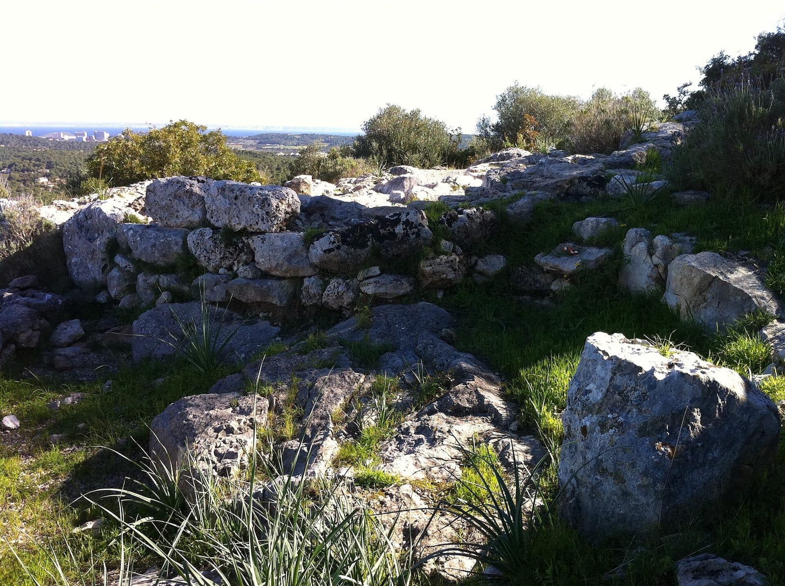

Puig de Sa Morisca rises above Mallorca’s densely populated southwest near Son Ferrer, yet it preserves an astonishing wealth of historical traces. On the hill and in its surroundings, Talayotic archaeology meets remains from the Islamic period of the Middle Ages and evidence of traditional woodland use. A visit is therefore more than a short climb to a viewpoint: it leads through a cultural landscape shaped over a long period of time.
The archaeological park covers around 45 hectares. More than 8 kilometres of trails provide access to open landscapes, archaeological sites, and viewpoints; the hill after which the park is named reaches 119 metres above sea level. These figures may initially sound manageable, but the terrain demands time for careful observation. Walls, stonework, and work sites cannot be understood at a single glance. That is precisely where the appeal lies: history does not appear here as a finished backdrop, but as a legible trace in the ground.
Puig de Sa Morisca is especially rewarding for travellers who enjoy combining archaeology with a walk. Visitors will find an extensive archaeological landscape park in which trails, ruins, traditional dry-stone structures, and views belong together. Families can also experience the park as a journey of discovery, provided that children are confident on uneven and occasionally steep ground. The real highlight is not merely a single find, but the shift between close-up details and distant views: first the masonry beside the trail, then the panorama across Santa Ponça, Son Ferrer, and El Toro.
History and Significance
Long before modern residential areas emerged around Santa Ponça and Son Ferrer, Puig de Sa Morisca offered a strategically advantageous location. From its summit, both the surrounding countryside and the bay of Santa Ponça could be surveyed. The archaeological remains show that the hill was not merely a settlement site chosen by chance, but a place used and reinterpreted across different periods.
The Talayotic Culture
The oldest defining traces belong to the Talayotic culture, which developed exclusively in the Balearic Islands. At Puig de Sa Morisca, Torre III is particularly associated with this cultural horizon. Its true impact only becomes apparent in the landscape: anyone looking out from the masonry across the surrounding countryside can understand, without elaborate staging, why this place retained its significance for so long.
The Islamic Middle Ages
The story does not end with the Talayotic period. Remains from the Islamic era of medieval Mallorca have also been preserved in the park. They make Puig de Sa Morisca a place with several historical layers rather than an exclusively prehistoric site. Different communities used the same ridge under different political and economic conditions.
This layering is particularly important for interpreting the site. An old wall or landform cannot be dated solely by its weathered appearance. The park demonstrates that archaeological landscapes were reused, reshaped, and given new meanings. The terrain therefore tells the story not of a single vanished place, but of repeated use.
The Christian Conquest of Mallorca
The area is also associated with the first battle of the Christian conquest of Mallorca. This gives the view towards the bay of Santa Ponça a historical dimension. Puig de Sa Morisca is therefore also a place of remembrance for the profound medieval shift in power on the island.
The significance of this episode lies less in a dramatic reconstruction than in the location itself. From above, it becomes clear why movements along the coast and routes into the interior could be observed from such a hill. Here, the landscape is part of the historical record.
From Archaeological Site to Archaeological Park
The park opened in 2002 to protect the area’s archaeological sites and make them accessible. Its concept is not limited to excavated walls, but treats the natural environment, views, historic woodland use, and archaeological sites as parts of a connected whole. As a result, Puig de Sa Morisca remains a landscape that can be explored on foot.
What to See
Trails climb through the park, stonework appears between open areas, and the view expands with increasing elevation. The archaeological remains are distributed across the hill and are interpreted while walking. Visitors who proceed slowly will find it easier to distinguish natural rock edges, constructed walls, and old working areas from one another.
Torre III
Torre III is a named archaeological feature of the park and provides an introduction to the world of the Talayotic culture. The changing perspective is particularly revealing: seen up close, the construction, materials, and sheer mass of the walls come to the fore. Torre III should therefore not be photographed merely as a ruin, because the view from the structure across the landscape is as much a part of the visit as the masonry itself.
The Medieval Traces
The remains from the Islamic period form part of a later layer of use. Anyone looking only for large walls can easily overlook their true value: within a relatively small area, it is possible to trace how Puig de Sa Morisca was revisited and used during widely separated periods.
For visitors, this means noticing differences rather than assigning every stone to a single period. The park is not a uniformly created ensemble. It is more like a historical archive in the open air, with pages composed of wall remains, edges in the terrain, and spatial relationships.
The Charcoal-Burning Sites
Not every trace in the park is prehistoric or medieval. Charcoal-burning sites recall the traditional management of the woodland and the production of charcoal. Such workplaces tell of everyday life that required physical experience, precise control of fire, and careful use of the available wood. They broaden the focus from political and military events to the work of ordinary people.
The charcoal-burning sites are worth seeing precisely because they are easy to overlook. They appear less spectacular than a stone tower, but they explain how the landscape was used economically. The woodland was not an untouched backdrop surrounding the archaeology, but a working landscape over a long period of time.
The Dry-Stone Walls
Dry-stone walls are also among the visible remains of traditional land use. Within the park, they combine skilled craftsmanship with locally available materials. Their understated form blends so closely into the ground that, from some distance, they almost seem to be part of the natural rock. They are therefore not merely decoration beside the trail, but an element of the historic cultural landscape.
The Trails and Viewpoints
More than 8 kilometres of trails extend through the archaeological park. Not every visit needs to cover the entire network. Instead, the trails allow different priorities: a shorter walk to archaeological remains, a climb to the highest point, or a longer circuit through the cultural landscape.
At the top, the view opens across Santa Ponça, Son Ferrer, and El Toro. The view of the bay of Santa Ponça is particularly striking because it connects landscape and history. From here, the modern development does not appear as the opposite of the archaeological site, but as the latest layer of an area long shaped by its location, proximity to the coast, and routes.
Visiting Puig de Sa Morisca
It is best to begin the walk without rushing. Puig de Sa Morisca is not a place where visitors follow a fixed sequence of rooms. Depending on the chosen route and walking pace, a visit usually takes 1 to 2 hours. Those who examine individual walls more closely or spend longer at the viewpoints can explore the park in greater depth.
The Climb
The trails are steep and rough in places. Sturdy footwear is therefore worthwhile even on the shorter climb. As the elevation increases, the view across the surroundings becomes more open; the scenery is not confined to the final viewpoint but develops along the way. This creates a pleasant rhythm of walking, stopping, and getting your bearings.
For a first visit, it makes sense not to collect as many trails as possible, but to combine Torre III, the traditional landscape features, and the highest part of the hill. This makes the park’s three main themes clear: early settlement, later use, and the strategic importance of the elevation.
The Best Time of Day
Early morning is particularly pleasant. There are fewer visitors then, and temperatures are generally more suitable for the climb than later in the day. The sun is especially noticeable on the exposed sections. Visitors interested in photography also benefit from having more peace in the morning to alternate between close-up images and landscape shots at the ruins and viewpoints.
Current access times should be checked before visiting, as they may change. Admission is free. For groups and school classes, the operator recommends making contact in advance; this makes it easier to prepare a visit with a stronger archaeological focus.
The Right Pace for a Visit
The ruins do not communicate through size alone. Many details only become visible when visitors deliberately walk slowly between the different sites. The charcoal-burning sites and dry-stone walls, in particular, can easily be overshadowed by the more conspicuous archaeological remains. A pause at a viewpoint also helps explain the site’s location: Son Ferrer, Santa Ponça, and El Toro become reference points within a historical landscape.
Getting There and Parking
From Palma and the airport, the journey initially leads to the southwest of the island. The stated driving distances and journey times refer explicitly to Son Ferrer, not to a car park immediately beside the archaeological site.
From Palma Airport
The road distance from Palma Airport to Son Ferrer is 32 kilometres. The drive takes around 37 minutes and follows the Ma-20 before continuing along the Ma-1. Because the visit continues on foot through hilly terrain, the driving time alone should not be confused with the time needed to reach the archaeological sites.
From Palma
From central Palma, the route follows the Ma-1 to Son Ferrer. The drive covers 22 kilometres by road and takes around 37 minutes. Despite the shorter distance, the time required is similar to the journey from the airport because the starting point and urban traffic can have a noticeable impact. Here too, the measured route ends in Son Ferrer; the visit then continues on foot.
By Bus
A nearby stop is named Puig de sa Morisca. Other stops are located along the roads in Santa Ponça and in the Sa Pinada area. From there, the visit continues on foot. When planning, it is important to check not only the outward journey but also the return trip and the latest connections. The park itself is ultimately explored via its trail network, not by travelling directly to each archaeological site.
The Final Approach
Regardless of the means of transport, the actual approach only begins on foot. The viewpoints and Torre III are located in hilly terrain, so sufficient time should be allowed between arriving in Son Ferrer and the planned end of the visit. The route should then be continued in suitable footwear.
Bus lines to Puig de Sa Morisca at a glance
| Line | Route | Departures/day | First | Last |
|---|---|---|---|---|
| 103 | Santa Ponça - Palma | 306 | 00:09 | 23:55 |
| 123 | Santa Ponça - Cas Català | 216 | 00:11 | 23:48 |
| 106 | El Toro - Palma | 141 | 06:21 | 22:52 |
| A11 | Peguera - Aeroport | 104 | 00:24 | 23:45 |
| 107 | Es Capdellà - Palma | 81 | 00:08 | 22:58 |
| 122 | Port d'Andratx - Santa Ponça | 72 | 06:53 | 23:20 |
| 131 | Santa Ponça - Banyalbufar | 6 | 10:15 | 17:30 |
From the official GTFS feeds (TIB/SFM), no real-time data. The figures cover all stops in the town; weekend and holiday services differ — check with the operator before travelling.
Getting there by bus
Puig de sa Morisca (11182) · 0.1 km as the crow flies
- 106El Toro - Palma · Daily
Av. Santa Ponça - Av. Golf (11201) · 0.4 km as the crow flies
- 106El Toro - Palma · Daily
Av. Santa Ponça - Gran Via del Port (11181) · 0.5 km as the crow flies
- 106El Toro - Palma · Daily
Sa Pinada (11089) · 0.7 km as the crow flies
- 122Port d'Andratx - Santa Ponça · Daily
- 123Santa Ponça - Cas Català · Daily
Santa Ponça oest 2 (11148) · 0.7 km as the crow flies
- 123Santa Ponça - Cas Català · Daily
Platja de Santa Ponça (11178) · 0.7 km as the crow flies
- 106El Toro - Palma · Daily
- 131Santa Ponça - Banyalbufar · Daily
Santa Ponça centre 1 (11188) · 0.8 km as the crow flies
- 103Santa Ponça - Palma · Daily
- 107Es Capdellà - Palma · Daily
Santa Ponça centre 2 (11179) · 0.8 km as the crow flies
- 103Santa Ponça - Palma · Daily
- 107Es Capdellà - Palma · Daily
- A11Peguera - Aeroport · Daily
Santa Ponça oest 1 (11147) · 0.8 km as the crow flies
- 106El Toro - Palma · Daily
- 123Santa Ponça - Cas Català · Daily
Caló d'en Pellicer 2 (11085) · 0.8 km as the crow flies
- 123Santa Ponça - Cas Català · Daily
Caló d'en Pellicer 1 (11086) · 0.9 km as the crow flies
- 106El Toro - Palma · Daily
- 123Santa Ponça - Cas Català · Daily
Santa Ponça est 2 (11091) · 1.1 km as the crow flies
- 103Santa Ponça - Palma · Daily
- 107Es Capdellà - Palma · Daily
- 122Port d'Andratx - Santa Ponça · Daily
- 131Santa Ponça - Banyalbufar · Daily
- A11Peguera - Aeroport · Daily
Timetable data: official GTFS feeds (TIB/EMT), no real-time — check with the operator before travelling.
Nearby Places
From Puig de Sa Morisca, three neighbouring areas can be viewed at the same time: Son Ferrer, Santa Ponça, and El Toro. The panorama helps visitors understand how they relate to one another. Son Ferrer spreads across the inland area, while Santa Ponça is more strongly defined by its bay. El Toro marks another point of reference along the southwestern coast.
Son Ferrer
Son Ferrer is the destination used in the travel information and a practical starting point for exploring the area. The archaeological park reveals a different side of these now developed surroundings. Instead of viewing streets and residential districts in isolation, the hill shows how they have grown into an older cultural landscape.
This contrast is precisely what makes the visit so illuminating. Puig de Sa Morisca is not far removed from all settlements, but forms a protected historical space close to modern daily life. Visitors arriving from Son Ferrer move in quick succession from the modern road network onto trails where stone structures, woodland management, and historic viewpoints define their orientation.
Santa Ponça
Santa Ponça can easily be combined with a visit to the park because the bay is already visible from the highest area. A subsequent stay on the coast turns the distant view into a closer perspective. At the same time, the historical connection remains present: the area is associated with the first battle of the Christian conquest of Mallorca.
For planning the day, it makes sense to visit the hill before the coast. An early climb takes advantage of the more pleasant time of day and the quieter trails; afterwards, the area around Santa Ponça can be explored. In this way, the archaeological visit is not an isolated activity but an introduction to the landscape surrounding the bay.
El Toro
El Toro is also part of the park’s panorama. It does not need to be planned as a major separate attraction to be useful for orientation. From Puig de Sa Morisca, it forms an easily understood spatial triangle with Son Ferrer and Santa Ponça. Anyone travelling through the southwest later will therefore find it easier to recognise how the coast, settlements, and hills relate to one another.
The place it belongs to
Son Ferrer in the place guidePractical Information for Your Visit
Loose stones, rough trail surfaces, and steeper sections define the practical character of the walk. Puig de Sa Morisca is an archaeological park, but it is also a hiking area. Clothing and equipment should therefore be chosen more for a short nature walk than for a museum visit.
Footwear, Water, and Sun
Sturdy shoes with good grip are the most important preparation. Even visitors who only want to walk part of the trails will not be moving through level exhibition halls. Water is especially important on warm days. The trails also cross open terrain, so continuous shade should not be expected. Sun protection is therefore just as useful as choosing a pace suited to the weather.
Early morning combines several advantages: fewer visitors, generally more pleasant conditions for the climb, and more peace at Torre III and the viewpoints. Those who start later should take greater account of the exposed terrain and choose the length of their route accordingly.
Visiting with Children
The park can be exciting for children because its history is not kept behind glass. Walls, stonework, charcoal-burning sites, and viewpoints follow one another directly along the route. Children must, however, be confident on uneven ground and carefully supervised on steeper sections. The visit works best as a discovery walk with breaks rather than an attempt to complete the entire trail network.
Torre III provides a good narrative focus: from there, it is possible to explain why elevated locations were important and why the view across the surroundings is itself part of the history. The charcoal-burning sites are also suitable for discussing earlier work in the woodland alongside themes of rule and conflict.
What Not to Expect
The most important remains are outdoors and require close attention to walls, landforms, and the location itself. Anyone without background knowledge who looks only for large, intact buildings may miss the subtler traces.
The value lies precisely in this openness. Archaeology, traditional woodland use, and the panorama explain one another. Torre III has a different impact once the bay comes into view; a dry-stone wall gains meaning when it is understood as part of a managed landscape. Taking time to stop is therefore more useful than trying to squeeze every trail in the park into a single short walk.
Local insider tips
Climb the Hill Early
Early in the morning, the trails are usually quieter and conditions are more pleasant for the occasionally steep climb. There is also more time at Torre III and the viewpoints to examine the masonry and landscape separately.
View Torre III from a Distance
Do not view Torre III only from close up. Taking a few steps back makes it clearer how the Talayotic structure occupied the ridge. Afterwards, it is worth turning to look out from the masonry across Son Ferrer and Santa Ponça.
Do Not Miss the Charcoal-Burning Sites
Look for traces of charcoal production among the archaeological remains. The old charcoal-burning sites are understated, but they offer a particularly vivid account of traditional work in the woodland and the use of the landscape.
Use the Bay as a Historical Map
From the elevated area, look deliberately towards the bay of Santa Ponça. The location explains why the hill was strategically important and connects the panorama with the first battle of the Christian conquest of Mallorca.
Choose a Route to Suit Your Time
The trail network covers more than 8 kilometres, but there is no need to walk every route. For a focused visit, Torre III, traditional landscape features, and the highest area can be made the main priorities.