
Torre de Cala en Basset – Historic Coastal Viewpoint
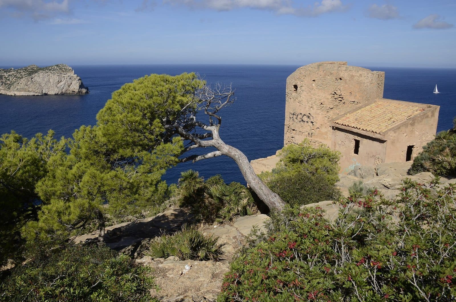

The Torre de Cala en Basset does not appear until late in the route, between pine trees and rocks. Then the squat round tower suddenly stands above the coast, with the open sea ahead and the elongated silhouette of Sa Dragonera beyond. This historic lookout post near S’Arracó is one of those destinations in southwestern Mallorca where the journey and the place itself are almost inseparable.
The tower was built in the late 16th century, when pirate attacks were not romantic seafaring tales for coastal residents but a genuine threat. Today, the Torre de Cala en Basset is primarily a viewpoint, hiking destination, and stone testament to that uncertain era. The view extends across the rocky Cala en Basset and the channel off Sa Dragonera; behind the tower rise the wooded slopes at the island’s western end.
The excursion is particularly rewarding for those who prefer discovering history in the landscape rather than in a display case. A hike through pine forest and increasingly rocky terrain leads to a structure whose location makes its former purpose immediately clear. Even without a lengthy tour of the interior, the tower remains an impressive destination. Its cylindrical silhouette, traces of later alterations, and the neighboring building tell of several phases of use. Yet the location itself leaves the strongest impression: from here, the sea route between Mallorca and Sa Dragonera could be monitored.
History and Significance
The Year 1583
In 1583, the Torre de Cala en Basset was built as a coastal watchtower and defensive tower. Its purpose was closely linked to the Freu de Sa Dragonera, the channel between Mallorca’s southwestern coast and the offshore island. Ships passing through could be detected early from the elevated position. This was particularly important for pirate vessels, whose attacks the tower was intended to help protect the coast against.
The tower is also known as Torre de Sa Rabassada. Together with other defensive towers in the southwest, including the towers of Cap Andritxol and Sa Mola, it formed part of a chain of posts used to monitor and secure the coast.
From Lookout Post to Monument
Its military significance ended in the 19th century. Although the site lost its original purpose, its commanding location continued to make it noteworthy. The structure did not decay into a completely illegible ruin: its round ground plan and essential parts of its internal access system remain recognizable today.
Today, the Torre de Cala en Basset is protected as cultural heritage and designated a Bé d’Interès Cultural. This classification applies not merely to a picturesque old tower but recognizes a structure that recounts the island’s defensive history and daily life along a coast threatened for centuries. At the site, it becomes clear why this particular rocky outcrop was chosen: the view over the sea route is extensive.
A Second Military Use
During the Spanish Civil War, the long-decommissioned lookout post once again took on a military function. From this exposed position, the airspace was monitored. The building beside the historic round tower was also constructed during this period.
This later addition makes the site more historically layered than a first glance might suggest. The tower does not tell only of galleys and pirates from the 16th century; it also demonstrates how a strategically advantageous observation point was reused in an entirely different era. Centuries separate the two phases, yet the site’s decisive characteristic remained the same: from this height, a broad expanse of coast, sea, and sky can be surveyed.
What to See
The Cylindrical Watchtower
Seen up close, the Torre de Cala en Basset appears more compact than some photographs with a wide seascape in the background might suggest. The cylindrical stone structure reaches a height of between 9 and 10 meters. Its enclosed, defensive form was not designed to impress; it arose from a clear military purpose.
The masonry bears traces of age, weather, and later alterations. This is precisely why it is worth resisting the urge to head straight for the view. Walking around the tower reveals how consistently its round form was adapted to the small site. Every perspective is shaped by stone, terrain, and the horizon beginning immediately beyond it.
The Altered Entrance
One particularly revealing detail is the present entrance arrangement. Access to the main floor is through a false doorway, while the original door was converted into a window. This alteration shows that the tower did not remain unchanged after its construction. What now appears to be a somewhat puzzling sequence of openings is the result of different uses and structural adaptations.
Inside, a staircase leads to the upper floor. This access arrangement is a reminder that historic coastal towers were not entered like ground-level homes. Whether and to what extent the interior can currently be entered should be checked before the excursion; the destination’s main appeal does not depend on it, however.
The Building from the Civil War
Beside the round tower stands a more recent building erected during the Spanish Civil War. At first glance, it is easy to see this structure merely as a disruptive extension. Historically, however, it belongs to the site’s second military phase, when the focus shifted from monitoring shipping to observing the airspace.
The contrast between the two structures is clear: the watchtower embodies the coastal defenses of the 16th century, while the neighboring building represents a modern form of military surveillance. Together, they show how strategically important landscape features can be reused over long periods. For understanding the site, this distinction is more important than the impression of a perfectly preserved historic setting.
Sa Dragonera and the Freu
The view is the main attraction. Sa Dragonera lies off the coast, its elongated, rocky form dominating the horizon. Between them opens the Freu de Sa Dragonera. This stretch of water explains the tower’s location better than any abstract description: passing ships had to move through a corridor that was easy to monitor.
Depending on the viewpoint, Es Pantaleu, the rugged coastline, and the slopes around Sant Elm also come into view. The panorama changes within just a few steps. Directly at the tower, Sa Dragonera dominates; to the side, the Cala en Basset becomes visible, while inland the pine trees and rocky heights define the character of the western Tramuntana foothills.
Cala en Basset and Morro de Sa Rajada
Below the lookout post lies the Cala en Basset. It is not a classic sandy cove but a rocky inlet with stone slabs, coarse gravel, and pine-covered slopes. Its shape is especially easy to understand from the elevated terrain. The deep blue water and irregular rocks create a striking contrast with the tower’s pale masonry.
The hike also opens up views toward Morro de Sa Rajada. As a result, the scenery is not limited to a single photo opportunity. The trail, tower, and cove create a sequence of different perspectives: first forest and terrain, then the historic structure, and finally the broad coastal panorama.
Visiting Torre de Cala en Basset
The Route from Sant Elm
A typical visit begins not directly at the tower but in Sant Elm. From the S’Algar area, the Camí de Can Tomeuí and Camí de Cala en Basset lead toward the historic lookout post. The official circular hike passes through pine forest and already offers initial views of Sa Dragonera, the Cala en Basset, and Morro de Sa Rajada along the way.
The route is described as a moderate hike. The official circular trail is 5,2 kilometers long and takes about 1 hour 30 minutes. This time should only be regarded as a guide for the walk itself. Anyone who examines the masonry, takes photographs, pauses at the viewpoint, or plans a detour toward the cove will need correspondingly longer. For a relaxed excursion, the tower should therefore not be squeezed between two tightly scheduled appointments.
The Rocky Final Section
Most of the trail is considered manageable, but the final section descending to the tower becomes rockier. Here, the character of the route changes: a woodland and gravel trail gives way to terrain that demands greater attention with every step. On the return journey, it is important to remember that the descent already completed must be climbed again.
Immediately beside the tower, the rocks drop away steeply. The view is therefore impressive, but keeping a safe distance from the edges is essential. This applies in windy conditions as well as when taking photographs, when attention can quickly shift from the ground to the screen. The site is well suited to a break, but not every level surface is automatically a safe place to sit or stand.
Time at the Tower
Viewing the structure itself does not require a lengthy guided tour. A walk around the tower, a look at the altered entrance, and an examination of the more recent neighboring building can all be completed in a manageable amount of time. Nevertheless, many visitors stay longer because the view deserves to be seen from several directions. Sa Dragonera looks different from directly ahead than from the Cala en Basset side, and even a brief change of position alters the relationship between the tower, sea, and rocky coastline.
The viewpoint is a popular hiking destination. Complete solitude should therefore not be treated as a guaranteed part of the experience. At the same time, visitors spread out along the trail and across the terrain rather than gathering in a single interior space. No fixed opening hours or admission details that can be reliably stated here are available for access. It is therefore advisable to check current information about access and possible restrictions before setting out.
Getting There and Parking
From the Airport to S’Arracó
From Palma Airport, the drive first follows the Ma-20 and then the Ma-1 toward the southwest. The route to S’Arracó covers 44 road kilometers via the Ma-20 and Ma-1. These directions expressly end in S’Arracó rather than at the tower, since the Torre de Cala en Basset has no direct road access suitable for a normal sightseeing stop.
From S’Arracó, continue by road toward Sant Elm. The usual hiking route begins there. The final stretch to the viewpoint is completed on foot and follows trails through pine forest and across rockier terrain. Navigation that uses only the tower’s name as a driving destination can therefore create a misleading impression: the drive and the walk are two clearly separate stages.
From Palma to S’Arracó
From central Palma, the route follows the Ma-1. The distance to S’Arracó is 33 road kilometers via the Ma-1. This figure also applies only as far as S’Arracó. From there, continue to Sant Elm and finally hike to the coast.
This distinction is important when planning the trip. The tower is not a viewpoint where a vehicle can be parked directly beside the masonry. Parking must be found in the departure point of Sant Elm or near the start of the trail. On busy days, it may be wise to allow extra time to find a parking space and locate the route to Camí de Can Tomeuí.
By Bus and on Foot
Cementeri de s’Arracó is the recorded bus stop in the S’Arracó area. From there, however, the Torre de Cala en Basset is not immediately accessible as part of a short walk around the village. Further planning must take into account the current connection toward Sant Elm and the subsequent hiking route.
Timetables and routes may change and should therefore be checked immediately before traveling. Regardless of the means of transport, the walk remains the decisive part of the visit. Anyone arriving by bus should not schedule the return journey too tightly, as viewpoint breaks, the rocky section, and possible detours are difficult to calculate to the minute.
Bus lines to Torre de Cala en Basset at a glance
| Line | Route | Departures/day | First | Last |
|---|---|---|---|---|
| 121 | Sant Elm - Andratx | 196 | 07:10 | 21:40 |
From the official GTFS feeds (TIB/SFM), no real-time data. The figures cover all stops in the town; weekend and holiday services differ — check with the operator before travelling.
Getting there by bus
Cementeri de s'Arracó (5029) · 1.8 km as the crow flies
- 121Sant Elm - Andratx · Daily
S'Algar (5017) · 2.1 km as the crow flies
- 121Sant Elm - Andratx · Daily
Sant Elm 2 (5014) · 2.1 km as the crow flies
- 121Sant Elm - Andratx · Daily
Sant Elm 1 (5015) · 2.2 km as the crow flies
- 121Sant Elm - Andratx · Daily
S'Arracó (5036) · 2.5 km as the crow flies
- 121Sant Elm - Andratx · Daily
Timetable data: official GTFS feeds (TIB/EMT), no real-time — check with the operator before travelling.
Nearby Places
S’Arracó
S’Arracó is more than a village passed through on the way to Sant Elm. With its houses, gardens, and traditional cafés, the small village retains a distinctly different character from the coast. Along Carrer de França stand buildings influenced by modernist architecture, recalling emigrants who sent money from France to their families in Mallorca.
Notable buildings include the church of Sant Crist and the former school Ca ses Monges, which is now used for cultural purposes. A short stop in the village places the excursion to the watchtower in a broader context: only a few stretches of landscape separate rural S’Arracó from the military coastal post, yet historically they served entirely different purposes.
Sant Elm
Sant Elm is the practical starting point for the hike and also a place from which Sa Dragonera is already clearly visible. From the coastal area, the route leads through S’Algar and along Camí de Can Tomeuí beyond the built-up area. The excursion therefore does not begin abruptly in open terrain. The transition from the village to pine forest and onward to the rocky coast is part of the route’s unfolding drama.
After the hike, Sant Elm offers an opportunity for a break by the sea. Those with more time can include the local beach or harbor area. Boat services to Sa Dragonera also depart from Sant Elm; combining the two activities, however, requires careful coordination with the current departure times and should not be scheduled too soon after the hike.
Cala en Basset and Sa Dragonera
The Cala en Basset lies below the tower and can be added to the hike as an extra detour. It is rocky, remote, and should not be confused with a developed sandy beach. Access to the water is over rocks, and the cove is exposed to the swell. The detour is therefore better suited to sure-footed hikers than to anyone looking for a spontaneous and comfortable swimming stop.
Sa Dragonera remains the scenic counterpoint to the tower throughout the excursion. Anyone who visits the island on another day will experience the historic lookout post from the reverse perspective, so to speak. La Trapa also lies within the wider hiking landscape. It is possible to connect the tower with longer coastal routes, but doing so requires separate route planning and should not be regarded as a casual extension of the short tower hike.
The place it belongs to
S'Arracó in the place guidePractical Visitor Information
Footwear, Water, and Navigation
Sturdy footwear with grippy soles is more important on the final rocky section than during the first few meters through the village. Smooth casual shoes make the return journey particularly difficult when loose stones and uneven steps must be negotiated uphill. Water should also be carried, as no facilities can be expected even at the Cala en Basset.
The route passes partly through pine forest, but this should not be mistaken for a continuously shaded walk. At the tower and along open stretches of terrain, there is no reliable protection from the sun. A hat and sun protection are therefore particularly useful on clear days. An offline map or previously saved route helps where junctions may seem less obvious than they do in Sant Elm.
Visiting with Children
The hike can be interesting for children accustomed to walking because the trail, tower, and island view provide a clear goal. The route’s length alone, however, is not the decisive factor. The rocky final section requires sure-footedness, and steeply dropping rocks lie immediately beside the tower. Children should be closely supervised there and should not walk around the structure unattended.
Families should allow generous time and include breaks. Anyone also planning to descend to the Cala en Basset should realistically assess the energy required for the return journey. The cove has no comfortable sandy access; rocks, coarse gravel, and an entrance to the water that quickly becomes deep define the terrain. The tower alone is already a complete excursion destination, even without this detour.
What Not to Expect
Nor is this a quick roadside photo stop. The effort involved in reaching the site on foot is part of the experience. In return, the destination reveals an unusually clear relationship between architecture and landscape: the view over the Freu explains the tower’s surveillance role, its enclosed form reflects its defensive purpose, and the more recent neighboring building demonstrates the site’s later reuse. This very legibility is what makes the visit worthwhile.
Local insider tips
Take a Closer Look at the Freu
The most important view is not only of Sa Dragonera but also of the channel between the island and Mallorca. This is precisely the passage that the tower built in 1583 was intended to monitor.
Look for the Original Door
The original door was later converted into a window; today, access to the main floor is through a false doorway. This inconspicuous detail reveals more about the alterations than a quick look around.
Do Not Overlook the Neighboring Building
The building beside the round tower dates from the Spanish Civil War. It belongs to a second phase of use, when the exposed location served to monitor the airspace.
Save Energy for the Return Journey
The final section descends over rocky terrain to the tower. What seems like a short descent on the way there must later be climbed again—especially after a detour to the Cala en Basset.
Read the Cove from Above
From the tower side, the rocky shape of the Cala en Basset is easier to recognize than it is down by the water. Only from above do the narrow inlet and pine-covered slopes become clear.