
Cap de ses Salines: Lighthouse at Mallorca’s Southern Tip
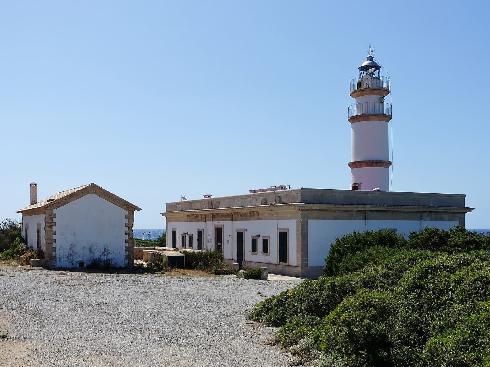

At Cap de ses Salines, Mallorca tapers into a flat, rocky coastline. The white lighthouse stands above the open sea, with the access road ending behind it and nothing but the horizon ahead. The destination feels less like a conventional attraction with a set tour and more like a striking endpoint of the island: the lighthouse, rocks, and water define the visit.
Its appeal lies precisely in this simplicity. There is no staged visitor experience to distract from the setting. Instead, the final steps lead from the roadside to the coast, the wind becomes more noticeable, and ever-changing views of the tower open up between the reddish stones. In clear weather, the Cabrera archipelago can be seen offshore.
The cape is well suited to travelers who enjoy coastal scenery, lighthouses, and quiet viewpoints. Hikers, road cyclists, and other active visitors also use the lighthouse as a destination or starting point. Families will find plenty to explore along the rocky coast, although the uneven ground requires close attention.
Anyone expecting a café will miss the character of the place. The real experience takes place outdoors. That is precisely why the cape works well as a short scenic stop or as the starting point for a longer walk along the coast.
History and Significance
The 1863 Lighthouse
Since 1863, the lighthouse has marked the coast at Mallorca’s southern end. Its purpose was practical from the beginning: to guide ships where the flat headland projects into the open sea. Unlike a fortress or a prestigious monument, the structure was not built to impress visitors. Its significance came from nighttime navigation and its highly visible position on an exposed coast.
The lighthouse remains operational. It is therefore not a decommissioned relic but part of the maritime infrastructure. By day, its clean white structure stands out most clearly against the barren surroundings; at night, the beacon continues to fulfill its original purpose. This continuity makes the site more historically interesting than a quick glance at a popular photo subject might initially suggest.
A Name Rooted in the Salt Landscape
The name Cap de ses Salines refers to the salt-flat landscape of southern Mallorca. The nearby town of Ses Salines also takes its name from the salt production that shaped this area over a long period. At the s’Avall saltworks near Colònia de Sant Jordi, salt is still harvested using traditional methods; according to the municipality, its history reaches back to Roman times.
The lighthouse itself is not a salt-production structure. Nevertheless, it belongs to a landscape whose identity has been shaped by seawater, low-lying coastal areas, and salt harvesting. This connection becomes clear while traveling through the south: fields and orchards lie inland, while salt flats, rocky shores, and the open sea appear closer to the coast. The tower stands at the outermost edge of this cultural landscape.
From Navigational Beacon to Excursion Destination
Today, the cape is visited for more than its nautical function. The lighthouse has become a landmark for walks, hikes, bicycle tours, and scenic drives. Its clean silhouette provides a focal point for an otherwise largely undeveloped stretch of coast. Many visitors first walk to the tower and then continue to the rocks by the water.
Its present-day fame therefore has two dimensions. For shipping, it remains an active beacon; on land, it represents the feeling of having reached the end of Mallorca. Changing light, an unobstructed horizon, and the chance to see Cabrera in the distance have turned this functional structure into one of the defining coastal images of the island’s south.
What to See
The White Lighthouse
The tower signals the end of the road even along the final stretch of the drive. White and without conspicuous ornamentation, it stands out clearly against the earthy colors of the landscape. Its impact comes not from an elaborate façade but from its isolated position above the coast. Viewed from different directions, the relationship between the building, sky, and sea changes: from the road, the lighthouse appears as the destination; from the rocks, it becomes a bright landmark behind the shore.
The visit centers on the exterior view and the surrounding coast. The reliable reason to make the journey is the sight of the still-operational beacon within its landscape.
For photographs, it is worth avoiding a position directly in front of the building. From a little farther away, the tower can be captured together with the low rocky coast. Up close, the structure dominates; down by the water, even a lighthouse appears small against the broad horizon. This change in perspective is precisely what makes walking around more interesting than taking a single souvenir photograph.
The Rocky Southern Tip
In front of the lighthouse begins a rugged shore of rock and loose stones. The coastline is flat but by no means as comfortable as a promenade. Reddish stones cover parts of the terrain, with informal tracks leading between them toward the water. When the sea is active, waves strike the rocks, and spray rises over the edge in suitable spots. The sound of the surf is often as defining here as the view.
Visitors have stacked the stones into small towers that stand out along the shore. They are not part of the lighthouse’s historical features, but they have become a recurring sight at the cape. Some see them as a playful detail, while others prefer to focus on the natural structure of the rocks. The terrain is correspondingly appealing to children, but loose stones and irregular edges require more attention than a developed viewpoint.
The sea feels particularly expansive here because no buildings restrict the view. The low coastline gives the sky plenty of space. The lighthouse provides a fixed point of reference: anyone who walks a short distance along the shore and looks back will see it repeatedly in a new relationship with the rocks and water.
Views of Cabrera
In good visibility, the outlines of the Cabrera archipelago appear offshore. The island group is a national park and a European bird protection area. From the cape, it remains a distant silhouette, yet this distance conveys just how open the sea route south of Mallorca is. A clear day is therefore especially rewarding for visitors who want to observe the entire horizon rather than simply photograph the lighthouse.
In spring, the view gains an additional natural-history dimension. Migratory birds can then be observed over the coastal area on their journey north. The cape is therefore not only a viewpoint but also a place where Mallorca’s position in the western Mediterranean becomes tangible. The island, open sea, Cabrera, and bird migration come together here in a single panorama.
Visibility naturally depends on the weather. Cabrera is not equally distinct on every visit, and haze can make the islands almost disappear. This does not diminish the site’s appeal: when long-distance views are less clear, the surf, rock formations, and white tower move more strongly into focus.
The Coastal Paths
There is no enclosed sightseeing circuit beginning at the lighthouse. Instead, paths and informal tracks continue along the rocky coast. The cape is therefore often used as a starting point for walks and longer hikes. Small, secluded stretches of beach can be reached on foot, but the route leads through natural terrain and should not be confused with a developed beach access.
Anyone who only wants to see the landmark can remain near the end of the road. Those who continue will increasingly experience the tower as a landmark behind them. The coastline itself then becomes the main attraction. For such walks, orientation, suitable footwear, and enough water are more important than for a brief photo stop.
Visiting Cap de ses Salines
From the End of the Road to the Sea
The visit begins without ceremony at the end of the narrow access road. Vehicles are left along the roadside, after which the route continues on foot toward the lighthouse and coast. The walk to the building is short; only once on the rocks does it become clear how much time can be spent here. Some visitors take a photograph and turn back, while others look for a place with an unobstructed sea view or follow the shoreline.
For an exterior-only visit, the cape can be treated as a compact stop. However, the site does not dictate a fixed length of stay. Anyone searching for Cabrera on the horizon, watching the surf, or continuing along the coast will naturally remain longer. Planning should therefore not be based on a set circuit but on whether the aim is to experience only the lighthouse or the coastal landscape as well.
Opening hours and admission details are not reliably documented. Because the lighthouse remains operational and the usual visitor experience focuses on its exterior and the coast, any potential access to the building should be checked before the trip. Entering the tower is not necessary to experience the cape.
From Photo Stop to Coastal Walk
The areas immediately around the tower and the end of the road receive the most visitors. Those who do not remain there but walk a little way across the rocks will find different viewpoints and spread out more naturally across the terrain. The transition is seamless: without a fixed route, a short stop can become a walk.
Light has a major influence on the atmosphere. In clear conditions, Cabrera stands out, while lower sunlight emphasizes the uneven rocks and the outline of the lighthouse. This does not provide a definitive best time of day, especially because weather and season change the impression. Anyone seeking fewer visitors should avoid the typical peak periods and allow some patience both on the narrow access road and when finding space along the roadside.
Stronger wind changes the experience considerably. The exposed landscape offers little shelter, the sea becomes louder, and extra caution is needed near the water’s edge. Calm weather is better suited to a longer stay on the rocks; in rougher seas, the surf is impressive without any need to approach the edge.
Getting There and Parking
From Palma Airport
From Palma Airport, the route initially leads to Ses Salines. This section covers 47 road kilometers and takes around 41 minutes. The route follows Ma-19, Ma-6030, and Ma-6014. These details explicitly apply only as far as Ses Salines and not to the lighthouse.
For the final stretch to the cape, continue onto Ma-6110. It branches south in the area between Ses Salines and Santanyí and passes through an increasingly open landscape until shortly before the coast. The road is narrower than the main routes used earlier and ends at the lighthouse. This section therefore requires more attention than the straightforward approach along the larger roads.
From Central Palma
From central Palma, the distance to Ses Salines is 53 road kilometers. The drive takes around 51 minutes and also follows Ma-19, Ma-6030, and Ma-6014. Only after that does the onward journey to the cape begin via Ma-6110. When planning the route, do not confuse the town name Ses Salines with the actual endpoint by the sea.
The long, seemingly straight final approach is already part of the experience. Buildings recede, and the lighthouse becomes the road’s visible destination. At the same time, there is no urban traffic infrastructure there. Allowing extra time is particularly sensible when many vehicles arrive at the end of the road or when slow-moving cyclists are traveling along the route.
Parking and Public Transport
Parking is available at the end of Ma-6110 or along the roadside before the cape. The site is not characterized by a large parking garage or managed visitor car park. Vehicles should be left in a way that keeps the narrow road and access route clear. From the parked vehicle, it is only a few steps toward the lighthouse.
No bus stop is documented in the immediate vicinity. The cape is therefore not a destination for which a direct bus journey can be planned without further research. For travelers without a car, a carefully prepared cycling route or a longer active excursion may be more suitable. Because of the exposed route, sun, wind, water requirements, and the return journey should be considered from the outset.
Nearby Places
Ses Salines
The town of Ses Salines is the natural intermediate stop on the way to the cape. It lies on a plateau in southern Mallorca and gave the headland its familiar connection to salt. Fields, orchards, and almond trees characterize the municipality, while the landscape opens toward the coast. Anyone who does not want to visit only the lighthouse can combine the excursion with time in the town.
Ses Salines also explains why the cape should not be viewed in isolation. The town’s name derives from the saltworks, and salt production remains part of southern Mallorca’s identity. Although the lighthouse stands by the sea rather than in a salt basin, the drive connects both sides of the same landscape: the agriculturally shaped town and the maritime southern tip.
Colònia de Sant Jordi and the Saltworks
Colònia de Sant Jordi is the coastal town of the municipality of Ses Salines. Nearby are the s’Avall saltworks, where salt continues to be harvested using traditional methods. The saltworks are located 7 kilometers from Ses Salines and combine particularly well with the cape thematically. A lighthouse visit can therefore become an excursion into the coastal and salt-making history of the south.
Connections toward Cabrera also depart from the harbor in Colònia. Anyone who has previously seen the archipelago only as a silhouette from the cape will find a suitable starting point there for exploring the national park more closely. Such a combination should, however, be planned as a separate undertaking rather than as a casual addition to a short lighthouse stop.
Natural Beaches and Coastal Paths
The southern coast is known for natural beaches and paths between rock, sand, and low vegetation. Es Carbó, Es Dolç, and Es Trenc are among the frequently mentioned destinations in the wider area. They should not be confused with the shoreline directly by the lighthouse: rocky terrain dominates at the cape, not a comfortably developed bathing beach.
A clear division therefore works well for a day trip. The lighthouse offers views, coastal atmosphere, and a walk across the rocks; the beaches or Colònia de Sant Jordi can each form a separate second destination. Anyone planning everything together should not underestimate the driving and walking involved and should allow enough time for the natural access routes.
The place it belongs to
Ses Salines in the place guidePractical Information for Your Visit
Footwear for Rocks and Loose Stones
There is no consistently level promenade directly by the water. Rock slabs, loose reddish stones, and irregular tracks define the terrain. Sturdy shoes with good grip are therefore advisable as soon as you leave the immediate area at the end of the road. Open footwear may be sufficient for a quick photograph but is poorly suited to a longer coastal walk.
After rain or when there is sea spray, slippery areas may require extra caution. This applies especially near the water’s edge. Watching the ground is more important than taking the most direct route to the sea, since the finest perspectives of the lighthouse can also be found at a safe distance from the edge.
Sun, Wind, and Limited Shade
The cape lies exposed beside the sea. Natural shade is scarce, and the wind can feel stronger than in the center of Ses Salines. Sun protection and drinking water are therefore essential, especially if a short stop turns into a walk. At the same time, wind should not be mistaken for cool conditions: on the unprotected coast, sun exposure can easily go unnoticed.
Do not assume there will be managed facilities directly at the lighthouse. The place is visited precisely because of its simplicity; a café, playground, and organized program are not the focus of the experience. Food and water are best purchased before driving along Ma-6110.
Visiting the Cape with Children
For children, the lighthouse can provide a clear destination, while the stones, waves, and small stacked towers make the shoreline interesting. The excursion does not require a lengthy sightseeing program. This is convenient for families because the visit can be adapted to attention spans, weather, and the desire to move around.
The terrain still requires supervision. Loose stones may shift, the rocks are uneven, and there is no continuous barrier beside the surf. Small children should therefore not be allowed to run ahead freely, especially near the water. When waves are stronger, the spectacle can be watched more safely from farther away.
Realistic Expectations
The dependable highlight is the outdoor setting: the white, still-active lighthouse, the rocky southern tip, the surf, and Cabrera in clear weather. Anyone seeking exactly that will find an impressive place with few distractions.
There is also no typical sandy beach directly in front of the tower. Swimming is not the focus in the documented descriptions of the lighthouse area; the shore is portrayed as rugged and rocky. Other destinations along the southern coast are better suited to a beach day. The cape itself is at its best for looking, walking, and consciously experiencing the end of the island.
Local insider tips
Step Back for the Better Shot
Do not stop directly in front of the lighthouse: from the rocks, the white tower can be photographed together with the coast, sky, and sea. Looking back along the shore reveals ever-changing perspectives.
Look for Cabrera on the Horizon
In clear weather, the Cabrera archipelago can be seen south of the cape. The view is best from the open rocky coast, where neither buildings nor tall vegetation obscure the sea horizon.
Spring for Birdwatchers
In spring, migratory birds can be observed at the cape on their journey north. Binoculars turn a lighthouse visit into a natural-history stop along the coast.
Combine the Lighthouse with Salt
The fitting thematic addition is the s’Avall saltworks near Colònia de Sant Jordi. Salt is still harvested there using traditional methods, giving both the landscape and Ses Salines their name.
Do Not Turn Back at the End of the Road
The first view is only the beginning. Anyone who walks a little way across the rocky coast in sturdy shoes and then looks back will experience the lighthouse as a landmark rather than merely a subject in front of the parking area.