
coll des Xoriguer Viewpoint near Fornalutx
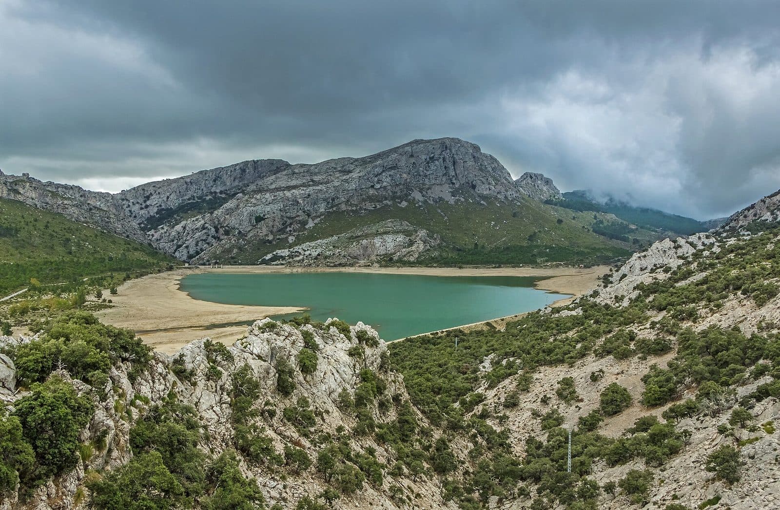

The coll des Xoriguer is a viewpoint near Fornalutx in northwestern Mallorca. Its appeal lies not in a building or exhibition, but in the elevated perspective over the mountain landscape that has shaped the village for centuries: the slopes of the Serra de Tramuntana, the Sóller Valley and Fornalutx, set among terraces.
This distinction is important because the coll des Xoriguer is not a conventional attraction with rooms, an interpreted route or a collection. Instead, it is a scenic stop for visitors who want to experience Fornalutx not only up close through its cobbled lanes, but also to understand the relationship between the village, the mountain slopes and the cultivated valley. The viewpoint is particularly suitable for travellers already exploring the Fornalutx and Sóller area. Hikers will also find it a useful point of reference, as steep mountain flanks, an old cultural landscape and routes through the Tramuntana come together around Fornalutx. Anyone expecting a developed attraction with a fixed sightseeing programme, however, should understand the nature of the destination.
Sources about the coll des Xoriguer itself are limited. This makes it all the more important not to confuse the site with similarly named mountains, landscapes or attractions. This article refers exclusively to the viewpoint near Fornalutx on Mallorca.
What to See
There is no single object at the centre of the coll des Xoriguer. What makes it worth seeing is the spatial relationship that becomes clearer from an elevated position than from below among the houses: Fornalutx sits on the slopes of the Puig Major massif, above the Sóller Valley and amid a cultural landscape shaped over a long period. The viewpoint therefore draws attention less to a monument than to the structure of the Tramuntana.
Fornalutx
Up close, Fornalutx is primarily experienced as a dense network of narrow cobbled lanes, stone steps and traditional houses. Many façades display the interplay of natural stone and green shutters typical of the village. From a viewpoint, however, the village's position on the slope comes to the fore: the buildings appear not as an isolated centre, but as part of the terrain.
This also explains why Fornalutx feels so steep on foot. Streets and stairways do not follow a level grid but adapt to the landscape. The coll des Xoriguer therefore provides the ideal contrasting perspective before or after a walk through these lanes. Below, doorways, flights of steps and individual façades stand out; from the broader landscape perspective, it becomes clear why the village developed in precisely this form.
The Sóller Valley
Fornalutx lies above Sóller in a valley strongly shaped by fruit cultivation. Terraced fields and irrigation structures reflect the long agricultural use of the slopes, with orange and lemon growing becoming a particular hallmark of the area. Looking in this direction therefore reveals not untouched wilderness, but a cultural landscape cultivated over generations and adapted to mountainous terrain.
These terraces are more than a picturesque backdrop. They illustrate how agriculture was made possible on steep slopes: usable land had to be carved from the hillside, supported and supplied with water. At the viewpoint, it is therefore worth looking not only for prominent peaks but also for the fine horizontal lines across the terrain.
The Puig Major Massif
The Puig Major massif rises above Fornalutx. Its proximity gives the village its distinctive mountain character and makes the surrounding area markedly different from the flatter parts of Mallorca. From the coll des Xoriguer, this topographical enclosure becomes the main subject: the valley opens between high slopes, while the village occupies one of their flanks.
The contrast between the massive mountains and small-scale land use is the viewpoint's most powerful image. On one side, rock formations and wooded slopes define the horizon; on the other, terraces, paths and houses reveal human labour across the terrain. This is precisely the quality of the coll des Xoriguer: the stop helps visitors read the landscape rather than perceive it merely as scenery.
Visiting the Viewpoint
A visit to the coll des Xoriguer does not follow a prescribed route. There is no established sequence of rooms, exhibits or architectural elements to work through. It makes more sense to take in the overall impression first and then consider the individual layers of the landscape: the village on the slope, the terraces below it and the higher parts of the Puig Major massif.
A Scenic Stop Rather Than a Sightseeing Programme
The amount of time required depends entirely on your plans. Visitors using the coll des Xoriguer merely as an intermediate stop will stay for a different length of time than those on a hike or taking an extensive walk through the village. Photographers and visitors wishing to examine the terrain and cultural landscape more closely will linger correspondingly longer. The nature of the site therefore does not suggest a fixed visit duration.
Opening hours and admission are also not recorded as reliable visitor information. As access and local regulations may change, current information should be checked before travelling. The viewpoint should not be treated like a staffed attraction with guaranteed access at all times.
Change Your Perspective
A visit is particularly revealing when combined with Fornalutx. Those who walk through the village first will recognise from the viewpoint the gradients and dense building pattern they have just experienced. In the reverse order, the coll des Xoriguer provides orientation before the broad lines of the landscape disappear from view among the houses.
There is no reliably documented best time of day for avoiding crowds at the viewpoint. Rather than relying on general recommendations, it is advisable to check current traffic and local conditions. At a scenic destination, the weather and visibility also have a greater influence on the experience than a fixed sightseeing programme.
Getting There and Parking
The reliable route information leads as far as Fornalutx, not directly to the coll des Xoriguer. This is crucial when planning: the stated road distances and driving times describe the journey to the village. For the final section to the viewpoint, consult current navigation information or a suitable hiking map before setting out, without assuming that reaching the village means there is vehicle access all the way to the viewpoint.
From Palma Airport
The road distance from Palma Airport to Fornalutx is 35 kilometres. The journey takes around 63 minutes, initially following the Ma-20 and then the Ma-11 towards Sóller. The time may seem long in relation to the distance, but it reflects the transition from the road network around Palma into the mountainous landscape of the northwest.
After travelling along the Ma-11, the route continues into the Fornalutx area. From there, the separately planned stage to the coll des Xoriguer begins. Because the route information explicitly ends in the village, it would be misleading to interpret the 63 minutes as the driving time directly to the viewpoint.
From Central Palma
The road distance from central Palma to Fornalutx is 30 kilometres. The journey along the Ma-11 takes around 68 minutes. This figure also applies only as far as Fornalutx. The slightly shorter distance does not automatically mean a shorter journey, as the starting point, city traffic and road layout all affect travel times.
For both routes, Fornalutx is the reliable point of reference. Only after arriving there should you use current route information to determine how to reach the coll des Xoriguer. Specific parking areas immediately beside the viewpoint are not recorded as confirmed visitor infrastructure. Vehicles should therefore be left only in clearly permitted places; access routes, property entrances and narrow paths must remain unobstructed.
By Public Transport
Cúber 1 and Cúber 2 are listed as bus stops in the wider area. However, this does not establish a fully documented walking route to the viewpoint. Anyone wishing to travel by bus should therefore not plan solely around the name of the nearest stop, but should check the entire connection, including the onward route on foot. In the Tramuntana, a seemingly nearby bus stop and a practically suitable access point can be two different things.
Bus lines to coll des Xoriguer at a glance
| Line | Route | Departures/day | First | Last |
|---|---|---|---|---|
| 231 | Port de Sóller - Alcúdia | 8 | 09:35 | 19:55 |
From the official GTFS feeds (TIB/SFM), no real-time data. The figures cover all stops in the town; weekend and holiday services differ — check with the operator before travelling.
Getting there by bus
Cúber 1 (19013) · 0.8 km as the crow flies
- 231Port de Sóller - Alcúdia · Daily
Cúber 2 (19012) · 0.8 km as the crow flies
- 231Port de Sóller - Alcúdia · Daily
Timetable data: official GTFS feeds (TIB/EMT), no real-time — check with the operator before travelling.
Nearby Places
The coll des Xoriguer benefits from having Fornalutx as a starting or finishing point. The village lies above Sóller on the slopes of the Puig Major massif and is known for its traditional mountain architecture. Natural-stone houses, green shutters, cobbled lanes and numerous steps define the village centre. The gradient is not a decorative detail, but an expression of its position on the slope.
Fornalutx
A walk through Fornalutx provides a close-up view of the landscape seen from the viewpoint. Among the houses, small architectural details move into the foreground, while the valley remains visible only in sections. The shift between the two scales is particularly rewarding: first the broad form of the mountains and terraces, then the narrow lanes and façades—or the other way around.
The village's history reaches back to the period shaped by Moorish influence. Terraced fields and traditional irrigation recall the early agricultural development of the terrain. After the Christian conquest, Fornalutx continued to develop into a village whose economy was closely linked to the orchards of the Sóller Valley. The viewpoint itself, however, is not a historic structure from this period; rather, the history explains the landscape towards which it directs the eye.
Sóller and Port de Sóller
Sóller lies below Fornalutx and is the nearest larger town suitable for combining with a visit. While Fornalutx has retained the character of a steep mountain village, Sóller reveals the more urban side of the valley. From there, the historic tram continues to Port de Sóller, linking the mountain landscape with the harbour.
This combination adds variety to an excursion without reducing the coll des Xoriguer to a mere intermediate stop. The viewpoint provides an overview of the landscape, Fornalutx offers a close look at traditional architecture, and Sóller or Port de Sóller adds the valley town and coast to the day. Which stop comes first depends on the selected route and current traffic conditions.
The Serra de Tramuntana
The wider area belongs to the Serra de Tramuntana, whose terrain offers numerous hiking opportunities. The coll des Xoriguer should not automatically be understood as the beginning of a particular signposted circular trail. Anyone wishing to continue from here needs a map suited to the planned route and should check the actual course of the path in advance.
The viewpoint works especially well as a scenic introduction: it shows why paths, settlements and cultivated areas in this part of Mallorca are so closely tied to contour lines and valley shapes. Afterwards, even short sections through Fornalutx feel less like an ordinary village walk and more like an encounter with a settled landscape adapted to the mountains over a long period.
Local insider tips
See the Overview Before the Lanes
Combine the coll des Xoriguer with a walk through Fornalutx: the viewpoint reveals the village's position on the slope, while among the stone houses you can then explore the small-scale architecture with steps and green shutters.
Look for the Terraces
Do not look only for peaks. The horizontal lines of the cultivated terraces reveal how the slopes around Fornalutx were farmed and connected to fruit cultivation in the Sóller Valley.
Plan the Final Route Separately
The reliable driving information ends in Fornalutx, not directly at the viewpoint. For the final section to the coll des Xoriguer, check current route information or a suitable hiking map in advance.