
Almallutx – Mallorca's Sunken Settlement at Gorg Blau
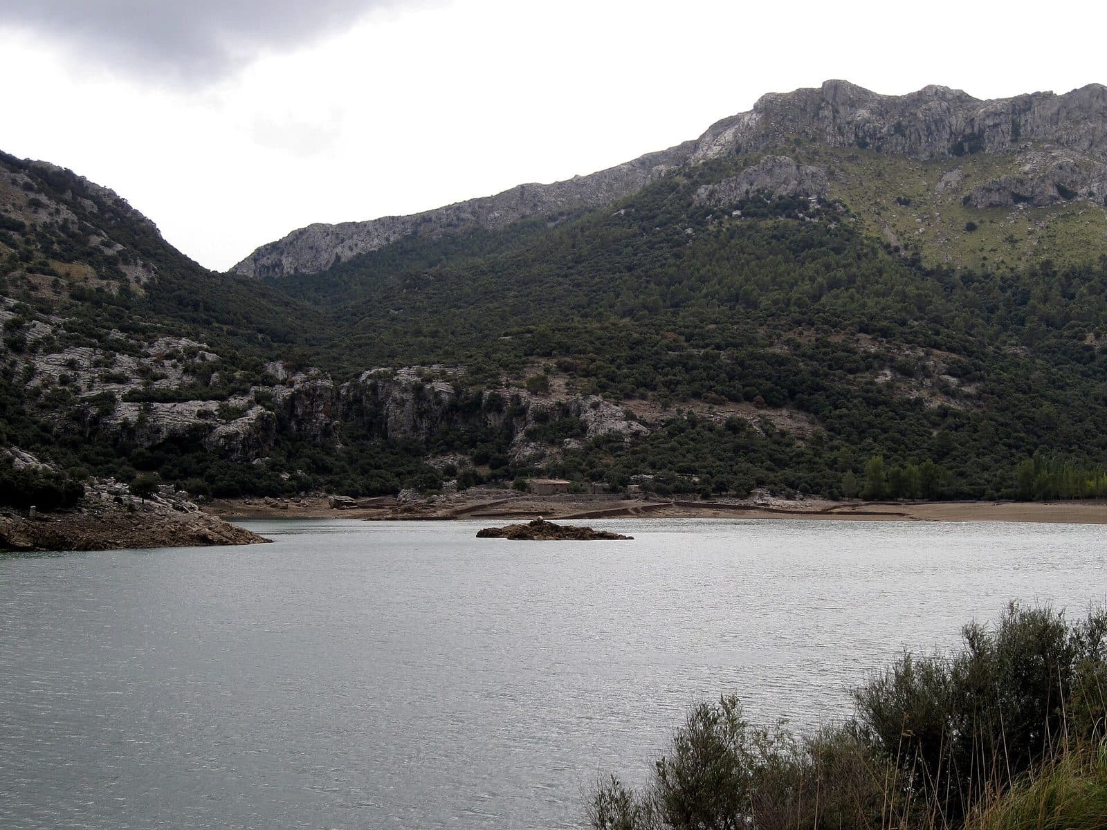

Almallutx does not reveal itself on demand. A large part of this archaeological site in northwestern Mallorca lies beneath the waters of Gorg Blau; only when the water level is low do walls, building remains, and pottery shards emerge more clearly. What is permanently displayed at other sites appears here only temporarily from the reservoir.
It is precisely this unpredictability that makes the place exceptional. Almallutx combines traces from widely separated eras: an important complex of the Talayotic culture and a large Islamic settlement where people sought refuge during the Christian conquest of Mallorca. The site therefore tells not only of worship and everyday life, but also of flight, resistance, and the later loss of an entire historic landscape beneath the water.
Almallutx is not a conventional archaeological park with an entrance, circular route, and explanatory stations. Depending on the water level, a visit may amount to a view across Gorg Blau, with individual stone structures or pillars barely distinguishable with the naked eye. Binoculars or a camera lens with a longer focal length can then reveal more than trying to reach the shore.
A visit is especially worthwhile for people who enjoy understanding archaeology within its landscape and historical context. Anyone expecting complete rooms, reconstructed houses, or a museum-style presentation will find little here. Those who can instead imagine the multilayered settlement hidden beneath the calm water will experience one of Mallorca's most thought-provoking archaeological sites.
History and Significance
When the water level was particularly low after a dry summer, archaeologists Jaume Deyà and Pablo Galera noticed structures in 2011 that were normally covered by Gorg Blau. Pottery shards lay among the remains of dwellings. This observation developed into a research project that was initially advanced with permission from the Island Council, volunteer helpers, and private donations.
The Prehistoric Place of Worship
The history of the valley reaches much further back than the medieval settlement. Archaeological traces are dated to around 2500 BC. Particularly important is the complex from the Talayotic period, the Iron Age culture that shaped Mallorca and Menorca. The sanctuary of Almallutx is dated from the 7th century BC onward; according to the available accounts, it remained in use until the Roman conquest.
The location was favorable for an early community: the valley connected parts of the mountains with Mallorca's plains, provided grazing land, and had springs that carried water throughout the year. Researchers therefore consider it possible that Almallutx was a religious center of island-wide significance for a long period. The main cult building is notable for its carefully dressed and precisely laid stones; its design resembles the sanctuaries of Menorca more closely than the usual Mallorcan examples.
The Last Islamic Settlement
The most dramatic phase began after the conquest of Mallorca by King Jaume I in 1229. Muslim inhabitants who had escaped the fighting withdrew into the remote mountains of the Serra de Tramuntana. An extensive settlement developed at Almallutx on the site of an existing alquería, interpreted by the archaeologists involved as the island's last major Islamic refuge.
The camp was not a collection of a few improvised huts but had the characteristics of an organized community. Residential buildings, two cemeteries, and the remains of a building that may have served as a mosque were found. Between 1229 and 1232, Almallutx thus became the center of those who continued to resist the Christian conquest or simply sought protection in the mountains.
The name also preserves a piece of this past. Almallutx is derived from Arabic and translated approximately as "field" or "meadow"—a reminder of the open, water-rich valley landscape that existed here before the reservoir was built.
The Valley Beneath the Water
The construction of the Gorg Blau reservoir fundamentally changed the site. The valley was flooded in the 70s; from then on, around 95 percent of the archaeological remains lay underwater for most of the year. Before that, a holm oak forest had concealed many structures. Yet the lake does not simply preserve the site: fluctuating water levels, currents, and erosion can loosen walls and displace finds.
Almallutx is therefore both an archaeological site and a threatened archive. Scientific work focuses not only on excavation and interpretation but also on documenting remains that may have changed each time they reappear. The reservoir makes the past visible—and then causes it to disappear again.
What to See
A few stones in the shallow shoreline area at Almallutx may belong to an entire house, while a single pillar rising above the water may be part of a sanctuary. The eye must first adjust to a site whose context is not explained by reconstructed walls or signs.
The Talayotic Sanctuaries
The prehistoric core is described as comprising four distinguishable structures. Broader accounts of the entire area mention two settlement zones and three sanctuaries. Particular attention is given to the main sanctuary, whose stone blocks were neatly worked and carefully fitted together. This precision suggests specialized craftspeople and a building in which considerable labor was invested.
The shape of the main building is considered unusual for Mallorca. Archaeologists see parallels with Menorcan sanctuaries. Its elevated position on the mountainside was probably also chosen deliberately: the place of worship stood above the valley, at a strategic passage between the mountains, grazing land, and routes toward the plain. Whether Almallutx truly was the central sanctuary of the entire island remains a scholarly interpretation; however, the size and quality of the complex make this assessment understandable.
At higher water levels, the impression is reduced to a few visible elements. From the road between Sóller and Lluc, individual pillars may be visible on the opposite side of the reservoir with strong magnification. Without optical assistance, the gray stones easily blend into the shore, rock, and reflections.
The Islamic Residential Areas
When the water falls far enough, walls and floor plans appear along the shore. They belong to a settlement built over an older rural farmstead. The residential buildings show that a larger community organized itself in the mountains. Pottery shards among the walls were particularly important in the rediscovery of the medieval area.
Not every visible line can be interpreted clearly on site. Walls end in the water, rooms remain partly hidden beneath sediment, and loose material may have been displaced by the reservoir. This is precisely what makes the site compelling for those interested in archaeology: Almallutx does not present the finished picture of an excavation, but rather the state in which researchers must first identify, define, and relate the evidence to one another.
The Possible Mosque
Among the medieval building remains is a structure interpreted as a possible mosque. Its significance lies less in a striking individual architectural feature than in its relationship to the settlement. An Islamic prayer space would confirm that people did not merely seek short-term shelter here, but maintained an ordered communal life.
The cautious wording is important: there is no fully preserved mosque on site whose function is immediately apparent to a visitor. What can be seen are archaeological building remains whose interpretation is derived from their location, layout, and context. Almallutx therefore requires more imagination than many monumental ruins.
The Two Cemeteries
Two cemetery areas also belong to the Islamic settlement. They show that the refuge was used over a longer period and that people not only lived here but also buried their dead. Together with the houses and the possible religious building, they create the picture of a self-contained settlement in the mountains.
Earlier excavations also produced the story of two skeletons found beside each other, a man and a young woman. The position of their hands was later interpreted as a Mallorcan version of Romeo and Juliet. This is a modern, romantic reading, not a confirmed account of a prehistoric drama. As a story about the discovery, however, it reminds us how quickly human gestures can inspire narratives even after a long time.
Gorg Blau as Part of the Site
The reservoir is not merely a backdrop, as its shoreline determines which parts of Almallutx become visible at all. When the water level is high, most of the site remains hidden; during prolonged drought, floor plans, stone settings, and areas containing finds emerge. Looking across the water is therefore always also a view of an invisible landscape.
Anyone who only photographs the lake can easily overlook the true scale of the place. Beneath the surface lie remains spanning millennia: prehistoric cult buildings, settlement remains, and the last major Islamic refuge during the conquest of Mallorca. The water visually connects these eras even though long periods separate them.
Visiting Almallutx
At Almallutx, the water level determines how a visit unfolds. There is no reliably visible set of ruins around which a fixed route could be organized. When the water level is high, the visit remains a scenic approach from the road beside Gorg Blau; in dry years, considerably more structures may emerge along the edge of the lake.
The View from the Road
The safest way to approach the site is to view it from the road between Sóller and Lluc. From there, the site lies across the water. Depending on the level, individual pillars or stone structures may be visible, but the distance and the similar coloring of masonry and rock make orientation difficult. Binoculars or a telephoto lens help without forcing a difficult route to the shore.
A short stop is enough for this overview. Those who study the landscape attentively, consider the historical context, and look for visible wall lines can stay considerably longer. There is no reliable standard duration for Almallutx because visibility and access vary more than at an established archaeological park.
Access at Low Water Levels
In years of water scarcity, a small footpath may allow visitors to approach, although access is still described as difficult. A low water level does not automatically mean that an unrestricted, secured visitor path has appeared.
The visible remains should be viewed from a respectful distance. Walls and pottery are not loose souvenirs but parts of a protected archaeological context. Precisely because the lake has already displaced and damaged material, it is important not to step on, move, or take anything.
Timing and Preparation
For Almallutx, the season is less informative than changes in the water level. The Islamic structures were rediscovered after a dry summer when the level was particularly low. However, this does not provide an annual guarantee. Before traveling, it is worth checking current information to see whether visits or expert-led appointments are being offered and which areas are accessible.
No reliable regular opening hours or admission details are recorded. Both should therefore be checked immediately before visiting. The question of the quietest time of day is also secondary at Almallutx: access, water levels, and traffic conditions on the mountain roads matter more than a conventional queue at an entrance.
Getting There and Parking
The long journey is part of the experience of this place. Almallutx lies at Gorg Blau deep in the Serra de Tramuntana, while the route details recorded here lead as far as Cala Tuent. This destination must not be confused with direct access to the archaeological area: from Cala Tuent, you must head back toward the mountain road and the reservoir.
From Palma Airport
The road distance from Palma Airport to Cala Tuent is 72 kilometers. The drive takes around 105 minutes and follows the Ma-30, Ma-13, and Ma-2130. This travel time ends in Cala Tuent, not at the Almallutx site. For the final section, the winding connection back toward Ma-10 and Gorg Blau is essential. The driving time should not be calculated as tightly as for an urban route, because the roads in the Tramuntana demand attention, and the final section is not used only by excursion traffic.
From Central Palma
From central Palma to Cala Tuent, the recorded route follows the Ma-13 and Ma-2130. It covers 69 road kilometers; the drive takes around 109 minutes. Here too, the distance and driving time refer explicitly to Cala Tuent. Almallutx lies farther inland at Gorg Blau, so the route must then return toward the Sóller–Lluc road and the reservoir.
The apparently similar distance despite the longer driving time is explained by the demanding mountain route. Hairpin bends and narrow sections determine the pace. Almallutx is therefore not a sensible spontaneous detour between two tightly scheduled activities, but a destination that requires enough time for both the outward and return journeys.
Parking and Public Transport
No bus stop is recorded in the immediate area. A car is therefore the more practical way to make a dedicated visit. Even then, the road does not lead to an excavation entrance that is open at all times. Final access depends on the water level, the condition of the path, and any protective restrictions.
Bus lines to Almallutx at a glance
| Line | Route | Departures/day | First | Last |
|---|---|---|---|---|
| 231 | Port de Sóller - Alcúdia | 8 | 09:35 | 19:55 |
From the official GTFS feeds (TIB/SFM), no real-time data. The figures cover all stops in the town; weekend and holiday services differ — check with the operator before travelling.
Getting there by bus
Cúber 1 (19013) · 2.4 km as the crow flies
- 231Port de Sóller - Alcúdia · Daily
Cúber 2 (19012) · 2.4 km as the crow flies
- 231Port de Sóller - Alcúdia · Daily
Timetable data: official GTFS feeds (TIB/EMT), no real-time — check with the operator before travelling.
Nearby Places
Between the reservoir and the sea, two very different faces of the northwest lie close together. Almallutx belongs to the secluded mountain landscape of Gorg Blau, while Cala Tuent opens onto the coast as a stony bay. Both places can be combined on a generously planned day trip without reducing the archaeology to a brief photo stop.
Cala Tuent
Platja de Tuent consists of pebbles and stones and lies between forested mountain slopes. Here, the sea feels like the end of a long valley rather than a broad holiday coastline. After exploring the flooded settlements of Almallutx, the bay vividly demonstrates how steep and inaccessible this part of Mallorca is.
Parking at Cala Tuent is limited. Visitors should not expect comprehensive tourist infrastructure at the beach either. The combination is therefore especially suitable for those who devote an entire day to the mountain and coastal landscape rather than ticking off several widely separated destinations.
Gorg Blau and Serra de Tramuntana
Gorg Blau itself remains the most important landscape reference point. Only a view of its extent conveys why such large parts of Almallutx are now hidden. The surrounding peaks and steep slopes also explain why the valley was strategically significant both for the prehistoric place of worship and for the Muslim refugees.
A visit can be incorporated into a drive through the central Tramuntana mountains along the road between Sóller and Lluc. Lluc is a useful additional reference point; in the other direction, the mountain road leads to Sóller. For planning purposes, choosing one of these places as an addition is enough. The bends and long driving times make an overloaded itinerary unnecessarily exhausting.
Sa Calobra
Sa Calobra and Torrent de Pareis also lie in this part of the mountains. They can in principle be combined with Cala Tuent, although they attract considerably more excursion traffic. Anyone visiting Almallutx for its silence and archaeological significance should reserve enough time at Gorg Blau before continuing to the busier coastal destinations.
The place it belongs to
Cala Tuent in the place guidePractical Information for Your Visit
Almallutx rewards preparation more than spontaneity. This applies not only to the route but especially to expectations: what awaits is not a fully excavated town, but a sensitive archaeological site whose visibility is determined by the reservoir.
Footwear and Terrain
The water level should never be understood as an invitation to walk freely across the site. Even inconspicuous rows of stones may be archaeological evidence. Pottery shards must remain where they were found because their position may be just as important to scientific analysis as the object itself.
Binoculars Instead of a Risky Approach
Binoculars are often more useful here than extra kilometers of hiking. In suitable conditions, pillars and stone settings that are barely noticeable with the naked eye can be seen from the road on the opposite side of the lake. A telephoto lens also allows observations to be enlarged later without entering sensitive shoreline areas.
The most important visual lesson is not to look for tall ruins. What becomes visible is more likely to be low walls, floor-plan lines, and individual projecting stones. Knowing in advance that two main historical phases overlap makes it easier to understand why the site does not look like a single, uniform settlement.
Visiting with Children
For children already interested in archaeology, the idea of a sunken settlement can be fascinating. However, the site offers neither an established circular route nor a reliably accessible exhibition. Young children should be supervised especially closely near the road, on steep shores, and over uneven ground.
Almallutx works best as a family destination with a short, vivid introduction: beneath the water lie sanctuaries, houses, cemeteries, and possibly a mosque. Without this background, younger visitors may see the lake as simply a lake because most of the remains are low, far away, or completely submerged.
Sun, Water, and Expectations
Do not expect reconstructed buildings, display cases, or a permanently visible temple. Almallutx is a research site in a landscape transformed by the reservoir. Its impact comes from knowing what lies beneath the surface—and from the few moments when the water releases parts of that history again.
Local insider tips
Pack Binoculars
At higher water levels, only individual pillars or stone settings can often be made out from the Sóller–Lluc road on the opposite side of Gorg Blau. Binoculars or a telephoto lens are more useful than a risky approach to the shore.
Water Level Before Time of Day
The water level matters more for visibility than the time of day. The Islamic structures were rediscovered after a dry summer when the level was particularly low; however, a dry period still does not guarantee access.
Look for Low Lines
The site does not appear as a tall ruin. Look for low walls, floor-plan lines, and individual projecting stones. Many visitors overlook them because the masonry, rock, and shore blend together in color.
Leave Shards Where They Are
Pottery and loose stones belong to the archaeological context. Do not pick up or move anything: at Almallutx in particular, the exact position of a find is important because water and erosion have already displaced material.
Combine It with Cala Tuent
After viewing the sunken valley landscape, Cala Tuent reveals the maritime side of the same rugged region. Allow a generously planned excursion day for both destinations, as the mountain roads are winding and slow.