
creu de Can Fat near Sa Pobla
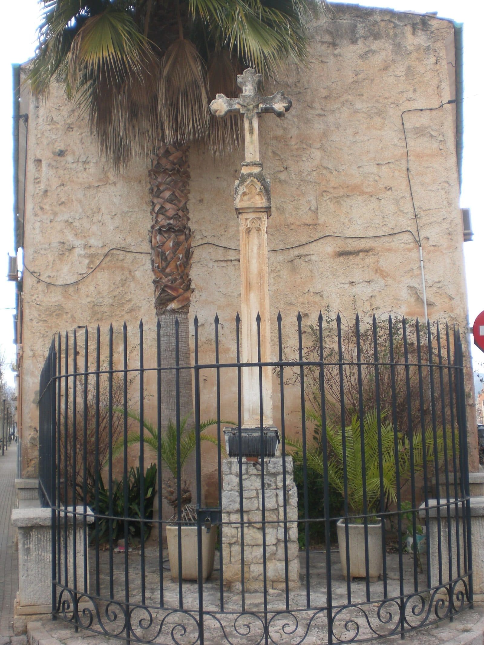

The creu de Can Fat is a historic monument near Sa Pobla in the north of the island. Its appeal lies in the direct encounter with a piece of local cultural history. The monument is classified as a Bien de Interés Cultural and is therefore recognised as protected cultural heritage.
A visit is particularly suitable for travellers who want to discover Mallorca beyond its major museums, castles and churches. The creu de Can Fat is a cultural and historical stop: visitors view the monument, consider how it fits into Sa Pobla and then take time to explore the town itself. This focus is precisely what makes it appealing. While a major attraction explains its significance through halls, information panels and displays, a monument like this requires a more attentive eye. Its name, historical classification and location provide the starting point. Those who engage with it will discover a form of Mallorcan heritage that continues to live on in the everyday life of the island’s north.
The creu de Can Fat should therefore not be confused with a landscape feature of the same name or a modern visitor attraction. This refers exclusively to the protected historic monument near Sa Pobla. It is best visited as part of a walk or a trip through the north.
History and significance
The key factor in its present-day classification is its recognition as a Bien de Interés Cultural. In Spain, this designation is used for cultural assets considered to have particular historical or cultural value. The creu de Can Fat is therefore not merely an incidental roadside detail, but officially recognised heritage considered worthy of protection. This classification draws attention to something that could easily be overlooked in passing.
This concept of protection is especially important for monuments, since their value does not depend on monumentality. The creu de Can Fat is a historic monument near Sa Pobla whose classification as a Bien de Interés Cultural identifies it as protected cultural heritage.
For visitors, this means that its significance is revealed less through a set route than through close observation and context. The monument should be viewed together with its surroundings. Its location near Sa Pobla is not an interchangeable backdrop, but part of its identity. Anyone looking only for a spectacular photo opportunity may easily underestimate its cultural and historical character. Those who want to understand how history has been preserved in the smaller signs of everyday Mallorcan life will find it a fitting place to visit.
Today, the creu de Can Fat stands above all for the conscious treatment of local heritage. It demonstrates that heritage protection does not begin only with cathedrals, fortresses or grand estates. A historic marker whose name has been passed down can also be important to a place’s collective memory. In this sense, its classification as cultural heritage is also an invitation to see Sa Pobla not merely as a transport hub in the north of the island, but as a historically evolved town.
Visiting the monument
The best approach is to view the creu de Can Fat as a historic monument near Sa Pobla and include it in a walk through the town. Orientation is the first consideration on arrival: the full name should be entered into the navigation system. Once it has been found, it is worth doing more than taking a quick look at the object. It is also interesting to observe how closely the monument is integrated into present-day life and how its historical character holds its own within the contemporary surroundings.
Current access conditions should be checked before travelling. No fixed opening hours are recorded, and no reliable admission price is available. This should not be taken to mean either that access is possible at all times or that a particular admission fee applies.
Anyone travelling specifically from Palma or a holiday resort should combine the creu de Can Fat with a visit to Sa Pobla. Pairing it with a walk through the town creates a coherent experience: first view the protected historic marker, then explore how it fits into the everyday life and structure of Sa Pobla.
For photography, a straightforward approach works better than trying to create a dramatic composition. A wide shot documents the location and captures the monument together with its surroundings, while closer views can draw attention to the historic fabric. Visitors should respect the site and avoid entering any adjoining private property.
Getting there and parking
From Palma Airport
From Palma Airport, the route initially follows the Ma-30 and then the Ma-13 to Sa Pobla. The road distance to the town is 47 kilometres, and the journey takes around 37 minutes. These details apply expressly to Sa Pobla. For the final section, an up-to-date navigation system should therefore be used with the full name creu de Can Fat.
The Ma-13 forms the main section of the journey into the north of the island. After leaving the main route, the character of the drive changes: instead of following a fast long-distance road, drivers must navigate Sa Pobla’s local street network. At this point in particular, it is worth setting the navigation system to more than just the town name. Sa Pobla is the destination of the stated route, while the monument must be located separately after arrival.
From central Palma
From central Palma, the road distance to Sa Pobla is 44 kilometres. The journey via the Ma-13 takes around 42 minutes. This journey time also technically ends in Sa Pobla; the search for the creu de Can Fat comes afterwards.
The direct connection via the Ma-13 makes the visit easy to combine with a trip to the north. Anyone who does not wish to travel solely for the monument can plan Sa Pobla as a cultural and historical stop along the way.
Parking at the destination
For the final section, an up-to-date navigation system should be used with the full name creu de Can Fat. When parking, take care not to obstruct access points, private property or areas subject to temporary restrictions. Conditions may change due to local events or traffic regulations. Those who allow sufficient flexibility can continue exploring Sa Pobla on foot immediately after visiting the monument instead of looking for a new parking space for every stop.
By public transport
The main options for orientation are Estació Sa Pobla 1 and Estació Sa Pobla 2, as well as Ronda nord 1 and Ronda nord 2. Which of these is most convenient for the final section to the creu de Can Fat depends on the current service and the precise access route to the monument.
Timetables and connections should be checked before departure. The stops confirm that Sa Pobla is connected to public transport, but they do not replace precise route planning for the section between the stop and the attraction. Anyone arriving by bus should therefore have the monument’s full name ready in an up-to-date map and allow enough time to find their way around the town.
Bus lines to creu de Can Fat at a glance
| Line | Route | Departures/day | First | Last |
|---|---|---|---|---|
| T2 | Palma - sa Pobla | 73 | 06:02 | 22:35 |
| 302 | Can Picafort - Palma | 57 | 00:05 | 23:45 |
| 315 | Sa Pobla - Badia d'Alcúdia | 42 | 00:15 | 23:25 |
| A32 | Can Picafort - Aeroport | 42 | 00:40 | 23:45 |
| 301 | Port de Pollença - Palma | 37 | 06:45 | 22:25 |
| 314 | Campanet / Búger | 12 | 07:51 | 19:40 |
From the official GTFS feeds (TIB/SFM), no real-time data. The figures cover all stops in the town; weekend and holiday services differ — check with the operator before travelling.
Getting there by bus
Ronda nord 1 (44011) · 0.7 km as the crow flies
- 301Port de Pollença - Palma · Daily
- 302Can Picafort - Palma · Daily
- A32Can Picafort - Aeroport · Daily
Ronda nord 2 (44010) · 0.7 km as the crow flies
- 301Port de Pollença - Palma · Daily
- 302Can Picafort - Palma · Daily
- 314Campanet / Búger · Daily
- A32Can Picafort - Aeroport · Daily
Estació Sa Pobla 1 (44013) · 1.0 km as the crow flies
- 315Sa Pobla - Badia d'Alcúdia · Daily
Estació Sa Pobla 2 (44012) · 1.0 km as the crow flies
- 315Sa Pobla - Badia d'Alcúdia · Daily
Sa Pobla Estació (219) · 1.1 km as the crow flies
- T2Palma - sa Pobla · Daily
Timetable data: official GTFS feeds (TIB/EMT), no real-time — check with the operator before travelling.
Things to see nearby
Sa Pobla is more than a geographical addition to the name of the creu de Can Fat. The town provides the monument’s cultural setting and helps visitors understand its scale correctly. Unlike coastal resorts focused heavily on beach tourism, this is a place to experience everyday life in northern Mallorca. Its streets, homes and local routes are not a tourist backdrop, but the present-day living environment in which a protected historic marker continues to exist.
After seeing the monument, it is therefore worth taking a walk through Sa Pobla without following a fixed sightseeing itinerary. Simply moving from the individual monument into the wider townscape shows why smaller cultural assets matter: they connect inherited names and historical traces with a space that remains in active use. The creu de Can Fat becomes easier to understand when it is not removed from this context.
Sa Pobla is also well suited as a stop on a journey through the north. The town can be reached from Palma and the airport via the Ma-13, allowing the monument visit to fit into a broader day trip. Rather than rushing to check off several distant individual destinations, it makes sense to focus on Sa Pobla and its immediate surroundings. This keeps travelling distances manageable and gives the historical stop sufficient context.
Those using public transport can organise their visit from the area around Estació Sa Pobla. When arriving by car, it is advisable to park and connect several locations in the town on foot. In both cases, the creu de Can Fat should be understood as one precise element of the visit: it offers insight into local cultural heritage, while Sa Pobla provides the setting for a longer stay.
The visit can be combined particularly well with a meal, a break or a general walk through the town. Specific businesses and event times may change, but the basic idea remains worthwhile: first look closely at the monument, then experience the town. This turns a photo stop into an encounter with Sa Pobla’s historical identity.
The place it belongs to
Sa Pobla in the place guidePractical visitor information
The creu de Can Fat is a historic monument whose value lies in both the object and its local context. Anyone who wants background information should read it before travelling, as explanations cannot be assumed to be available on site.
In sunny weather, take water and suitable sun protection, especially when combining the creu de Can Fat with a longer walk through the town. Arrival, orientation and the rest of the walk all add to the time spent outdoors. The monument should neither be climbed nor treated as play equipment.
Up-to-date information on accessibility should be obtained in advance. Its classification as protected cultural heritage does not indicate whether the immediate access is step-free, the ground is level or sufficient space for movement is available. Anyone requiring an accessible route should therefore check the specific route from their chosen bus stop.
Respect for the monument and its surroundings is more important than getting as close as possible for a photograph. Adjoining private areas and access routes should likewise be kept clear. Paying attention means taking in the location, viewing the cultural asset carefully and placing it within the context of Sa Pobla.