
es Claper des Gegant: Prehistoric Settlement near Canyamel
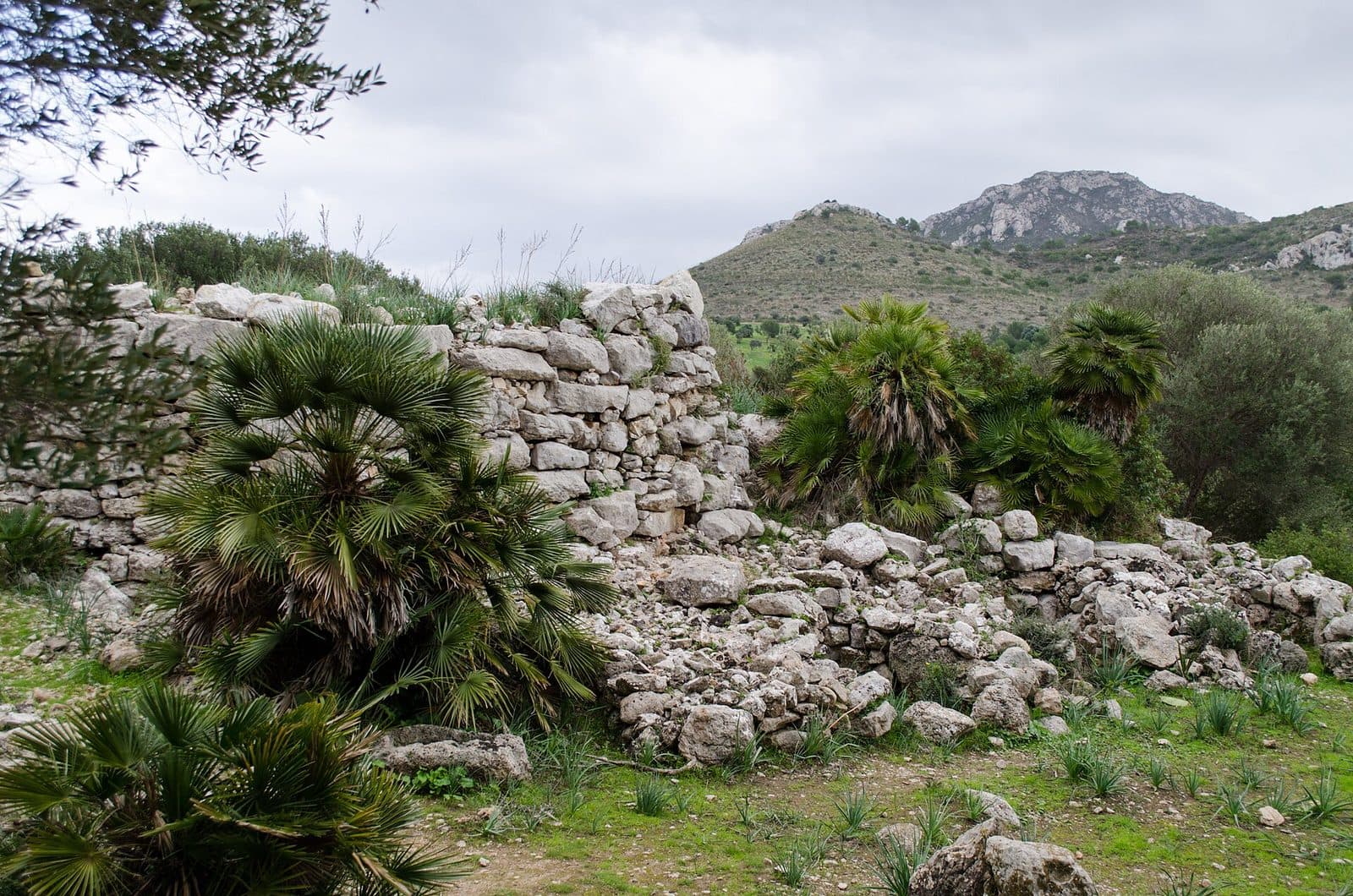

Between Canyamel and the coastal landscape of northeastern Mallorca lies es Claper des Gegant, a place where prehistory is not displayed behind glass. Here you can see the stone remains of a settlement that existed long before the Roman occupation of the island. Walls, passageways, and rooms of different shapes lie exposed across the site; plants have grown between many of the structures, making the site both appealing and challenging to interpret.
The archaeological site is also known as the prehistoric settlement of S’Heretat or as Talayot de s’Heretat. Its special value lies not in a single, completely preserved monument but in the interplay of talayots, settlement rooms, an enclosing wall, and smaller outlying buildings. It conveys the sense that an entire living environment was once organized here. Those who take their time will gradually recognize floor plans in the low stretches of wall rather than mere piles of stones.
A visit is especially worthwhile for travelers who want to discover Mallorca’s history beyond castles, churches, and manor houses. Multilingual information panels help provide context, but genuine understanding comes from looking closely: Where does a wall run? Where does an entrance open? Which structural elements belong to a round room, and which to a rectangular one?
This understated presentation is precisely what shapes the experience, as es Claper des Gegant is not a site that can be fully grasped in passing. Vegetation obscures some of the archaeological lines, while other stretches of wall emerge with surprising clarity. For history enthusiasts, families with older children, and anyone seeking a peaceful alternative to the beach, the site is therefore a rewarding destination.
History and Significance
The Mallorcan name sounds like an old tale: “Claper des Gegants” can be understood roughly as the stone field of the giants. In Mallorca, this term was commonly used for areas containing imposing remains of prehistoric structures built from large stones. The name therefore refers to the archaeological site, not to a historical person.
The Settlement of S’Heretat
The site itself lies on the S’Heretat estate and is therefore also called the prehistoric settlement of S’Heretat. It dates from the period before Roman rule in Mallorca and is associated with the Talayotic culture. The site includes several talayots. Local presentations illustrate its age by looking back at Mallorca around 3000 years ago.
Crucially, this is not merely an isolated talayot. The surviving structures belong to a settlement complex: several talayots, rooms of different shapes, a protective wall with entrances, and smaller buildings outside this boundary reveal an organized community. From a modern perspective, much remains fragmentary, but enough of the spatial arrangement survives to distinguish between large central buildings, rooms of different shapes, and the settlement boundary.
Before the Roman Occupation
Es Claper des Gegant offers access to a layer of the island’s history that is easily overshadowed by Mallorca’s better-known Roman and medieval sites. By the time the Romans arrived on the island, the indigenous population had already spent a long period developing its own settlements and building styles. The ruins near Canyamel are a physical remnant of this pre-Hispanic and pre-Roman world.
The walls do not tell a complete chronicle of rulers, battles, and clearly dated individual events. Their meaning lies in the construction itself: large stone blocks were assembled into walls, interior and exterior spaces were separated, and entrances were built through the settlement boundary. The site demonstrates that Mallorca’s early inhabitants created permanent, deliberately designed settlements.
From Living Space to Archaeological Monument
What was once used as a settlement is now an archaeological site on private land. Weathering and plant growth have altered its appearance over a long period. Some walls can be followed easily, while others disappear beneath vegetation or visually merge with the stony terrain. This makes a quick overview more difficult, but it also preserves the character of a site that has not been completely reshaped.
Today, the significance of es Claper des Gegant lies precisely in the remains as a whole. A single stone explains little; the sequence of walls, openings, and room shapes, by contrast, allows the site to emerge as a settlement. Multilingual panels support this interpretation, but they do not replace an attentive walk during which the structure becomes clear piece by piece.
What to See
The first impression can be deceptive. Between earth, low vegetation, and seemingly loose stones, some sections initially appear disorganized. Once your eyes begin following the lines of the walls, a structured site emerges: round, rectangular, and oval rooms, several talayots, passageways through the enclosure, and smaller buildings outside the protected area. The contrast between clearly preserved sections and floor plans that are barely legible makes the walk particularly engaging.
The Talayots
The talayots are the most striking remains at the site. Such monumental buildings are characteristic features of prehistoric Mallorcan architecture. At es Claper des Gegant, they do not stand alone but form part of a larger settlement complex. This means they can be viewed not merely as individual monuments but as elements of a place whose inhabitants coordinated paths, rooms, and boundaries. Their massive stonework defines their visual impact, and their outlines are often easier to recognize when looking along the walls from the side than from close range.
Round, Oval, and Rectangular Rooms
The different room shapes are among the site’s most important features. Circular, oval, and rectangular areas can all be distinguished within the complex. Their variety shows that the site was not built according to a single basic pattern. Instead, different structures were connected and made accessible through entrances.
Not every room is equally well preserved. In some places, connected stretches of wall mark out a floor plan, while elsewhere only sections remain visible. Vegetation further limits the overall view. It is therefore helpful not only to look into an apparent room but also to walk around the outside of its wall and search for the next corner or curve. In this way, shapes emerge that remain hidden from a single viewpoint.
The Enclosing Wall
A wall protected or defined the settlement area. Several entrances led through it. This structure is essential for understanding the site because it separates the inner complex from the structures outside it. Where an entrance can be identified, the transition is particularly easy to understand: what first appears to be a simple gap becomes a deliberately constructed passageway.
The enclosure should not be mistaken for a completely preserved defensive wall. Today, it survives in sections and at varying heights, but it still organizes the landscape. Following its course for a while provides an idea of where the center of the settlement lay and where people could enter the enclosed area.
The Outlying Buildings
Smaller buildings also stood outside the wall. They are easy to overlook because attention is initially drawn to the talayots and the more compact structures inside. Yet these inconspicuous remains expand the overall picture: life was apparently not confined to a single, sharply enclosed group of buildings.
During the walk, it is therefore worth looking beyond the interior. Low stretches of wall outside the boundary may belong to these smaller buildings. They show that the archaeologically important area extends beyond the most impressive stone structures. Stones should not be moved, rearranged as seats, or used as surfaces, because even inconspicuous layers may form part of the archaeological evidence.
The Information Panels
Multilingual panels at the site provide an introduction to its history and structure. They are particularly useful before venturing farther among the walls. With an initial picture of the talayots, enclosure, and room shapes, it becomes easier to interpret the visible remains.
Vegetation leaves some connections unclear. Visitors who use the information as a starting point rather than a complete explanation will experience the site most fully: read, observe, examine the course of the walls, and then look again from a greater distance.
Visiting the Site
The approach is made on foot through rural terrain. One described option is an approximately 500 meter unpaved path from a small parking area near the road by the Canyamel golf course. Another option is the signposted municipal hiking route from Font de Sa Cala. Which choice is suitable depends on your starting point and the current access arrangements.
Getting Oriented at the Start
At the beginning of the visit, it is advisable to pause briefly at the information panels. The ruins are not self-explanatory at first glance because many walls survive only as low sections and plants have reclaimed parts of the site. Those who first look for the enclosing wall, entrances, and talayots will find it easier to identify the smaller rooms afterward.
A slow walk is then more useful than quickly checking off individual structural features. The site appears different depending on the direction of view: from one side, a wall may look like a loose line of stones, while a few steps farther on its curve becomes visible. Comparing the more massive talayot structures with the smaller rooms of different shapes is particularly revealing.
Time Needed and Pace of Visit
It is difficult to impose a single fixed duration on a walk around the site. Those seeking only a brief impression can focus on the information panels, the talayots, and one section of the enclosing wall. Visitors with an interest in archaeology will need considerably longer because many floor plans become clear only when walking around the walls. The walk from the starting point must be added to the time spent within the archaeological site itself.
The site is therefore suitable both as a dedicated archaeological excursion and as part of a day trip around Canyamel. Planning should take into account that the archaeological site lies on private land and access may be regulated. Current visiting options should therefore be checked before setting out. Specific opening hours and admission conditions may change and should be confirmed through an up-to-date inquiry rather than included in long-term itinerary planning.
Atmosphere and Visitor Flow
The appeal lies in peaceful, independent exploration. At the same time, there is no reliably documented daily time when the site is generally empty. Anyone seeking a quiet visit should therefore allow enough flexibility rather than squeezing the walk between two fixed activities.
Across the open, partially overgrown terrain, light and shadow affect how clearly the edges of walls can be seen. A supposedly ideal time for photography matters less than maintaining a relaxed pace. Taking a few steps back, looking sideways along the stones, and repeatedly comparing the remains with the panels is more rewarding than trying to photograph as many individual subjects as possible in quick succession.
Getting There and Parking
Regional driving directions lead to Sa Costa de Canyamel or Costa Canyamel, not directly to every access point for the archaeological site. The final section leads into the rural surroundings of es Claper des Gegant and is completed on foot. As the site lies on private land and access arrangements may change, current local route guidance should be followed.
From Palma Airport
The road distance from Palma Airport to Sa Costa de Canyamel is 76 kilometers. The drive takes around 63 minutes and follows the Ma-15, then the Ma-4030 and the Ma-4040 into northeastern Mallorca. The Ma-15 covers the long section across the island; only on the later roads does the route approach the Capdepera and Canyamel area.
The measured driving time ends in Costa Canyamel. It does not automatically include the search for the correct starting point or the walk to the ruins. An additional time buffer is therefore advisable for a relaxed visit, especially if the local signs or current access situation must first be checked.
From Central Palma
The road distance from central Palma to Sa Costa de Canyamel is 78 kilometers. The drive takes around 70 minutes. This route also follows the Ma-15, the Ma-4030, and the Ma-4040. It provides a direct drive to the northeast of the island but should not be mistaken for road access directly to the prehistoric walls.
After the regional road section, continue toward Canyamel and the area near the golf course. An approximately 500 meter unpaved path to the settlement is described from a small parking area not far from the road. This final section is already part of the visitor experience: instead of an urban museum entrance, a rural footpath awaits.
Parking and the Final Walk
The mentioned parking area is small. Visitors should therefore not expect a large facility or numerous marked spaces. Access roads, property entrances, and paths must not be blocked. If the intended access point is not clearly visible or is closed, do not search for an alternative track across private land.
The unpaved path requires more attention than a paved museum entrance. After rain, the surface may differ from conditions during dry periods, so sturdy shoes are the more reliable choice. The municipal hiking route from Font de Sa Cala provides another approach on foot and is especially suitable for an excursion in which the journey itself forms part of the experience.
Arriving by Bus
Stops in the wider area include Cala Provençals, Sa Font de sa Cala 1, Sa Font de sa Cala 2, and Na Taconera 2. None of them eliminates the need to walk to the archaeological site. The current connection, correct walking direction, and return journey should therefore be checked before departure.
For a bus trip, combining the journey with a hike is more practical than expecting to get off directly in front of the entrance. The signposted route from Font de Sa Cala is the most important reference point. As timetables and routes may change, the specific connection should be included in the day’s up-to-date travel planning.
Bus lines to es Claper des Gegant at a glance
| Line | Route | Departures/day | First | Last |
|---|---|---|---|---|
| 423 | Font de sa Cala - Cala Rajada | 112 | 08:00 | 21:55 |
From the official GTFS feeds (TIB/SFM), no real-time data. The figures cover all stops in the town; weekend and holiday services differ — check with the operator before travelling.
Getting there by bus
Cala Provençals (14040) · 1.7 km as the crow flies
- 423Font de sa Cala - Cala Rajada · Daily
Sa Font de sa Cala 2 (14038) · 1.7 km as the crow flies
- 423Font de sa Cala - Cala Rajada · Daily
Sa Font de sa Cala 1 (14039) · 1.7 km as the crow flies
- 423Font de sa Cala - Cala Rajada · Daily
Na Taconera 2 (14006) · 1.9 km as the crow flies
- 423Font de sa Cala - Cala Rajada · Daily
Na Taconera 1 (14005) · 1.9 km as the crow flies
- 423Font de sa Cala - Cala Rajada · Daily
N'Aguait 2 (14037) · 2.7 km as the crow flies
- 423Font de sa Cala - Cala Rajada · Daily
N'Aguait 1 (14010) · 2.7 km as the crow flies
- 423Font de sa Cala - Cala Rajada · Daily
Timetable data: official GTFS feeds (TIB/EMT), no real-time — check with the operator before travelling.
Nearby Attractions
After the quiet stone walls of prehistory, Canyamel feels like a transition into another layer of time. The small coastal town lies on the Torrent de Canyamel between wooded hills and the sea. The stream divides the town, and a wooden walkway follows its banks toward the coast. Restaurants, shops, and Platja de Canyamel make the town a practical stop before or after the archaeological walk.
Canyamel and Sa Costa de Canyamel
In landscape terms, es Claper des Gegant belongs to the Sa Costa de Canyamel or Costa Canyamel area. The surroundings are less urban than many of the island’s well-known resorts. Golf grounds, rural paths, coastal hills, and scattered development shape the transition between the archaeological site and Canyamel.
This contrast is appealing when planning the day: first comes the focused search for prehistoric floor plans in stony terrain, followed by a walk along the Torrent or a break in town. Platja de Canyamel is an easy option for ending the outing without turning the archaeological visit into a lengthy transfer elsewhere.
Coves d’Artà
At Cap Vermell lie the Coves d’Artà, one of the best-known attractions along this stretch of coast. They combine well with es Claper des Gegant because the two places reveal very different aspects of the landscape: human-built walls from a prehistoric settlement on one hand and natural underground formations on the other.
Even so, the two visits should be planned separately within a combined day. The archaeological site requires a walk and independent orientation, while the caves operate under a different visitor system. Those who avoid rushing will retain enough attention for the subtle details of es Claper des Gegant.
Torre de Canyamel and Castell de Capdepera
Torre de Canyamel dates from the Middle Ages and provides a nearby historical counterpoint. Together with the prehistoric settlement, it creates a broad chronological arc without requiring travel to another region. However, the two structures should not be confused: the talayot site tells the story of the prehistoric population, while the tower belongs to a much later era.
Castell de Capdepera is also a suitable addition to a history-focused excursion. There, a medieval fortification takes center stage. Visitors who see both places can clearly recognize how differently stone architecture was used in Mallorca: as a settlement structure in prehistoric times and as a highly visible fortification in the Middle Ages.
Font de Sa Cala and the Coast
Font de Sa Cala is not only a nearby coastal town but also the starting point of a signposted municipal hiking route to the archaeological site. This makes it possible to include es Claper des Gegant in a more active outing in which the walk to the site plays a greater role.
Smaller coves and coastal walks are also available nearby. A sensible order depends on the weather and access conditions: in pleasant conditions, the hike can come first, while Canyamel later offers opportunities for the beach, refreshments, or a walk along the Torrent. The archaeological site remains the thematic focus and should not be treated as a hurried stopover.
The place it belongs to
Sa Costa de Canyamel (Costa Canyamel) in the place guidePractical Visitor Information
Among the surviving walls, it quickly becomes clear that es Claper des Gegant is not a polished museum site. Access may follow an unpaved path, the ruins lie exposed in the landscape, and vegetation makes some floor plans difficult to recognize. Good preparation therefore depends less on extensive equipment than on having the right expectations.
Shoes and Clothing
Sturdy, closed shoes are advisable on the unpaved approach and across the stony ground. Sandals with little support are less suitable for a place where attention is often focused on the walls rather than the next step. Clothing should be appropriate for the weather and for spending time outdoors.
As the settlement is not housed inside an enclosed exhibition hall, there is no consistently sheltered route. Sun protection and drinking water are sensible preparations in warm weather. After wet days, additional caution is required on the earthen path.
Visiting with Children
For children, the “stone field of the giants” can provide an engaging introduction to the site. Instead of reading lengthy information panels in full, families can search together for round rooms, entrances, and the enclosing wall. This turns the ruins into an observation challenge: Which sections of wall belong together, and where might a passageway have been?
Adults should remain close by. Loose stones, uneven ground, and low walls do not form a climbing course. Moving even small stones should also be avoided, as archaeological evidence consists of more than only the largest and most striking blocks.
Finding Your Way Around the Site
A photograph of the information panel, or a careful look at its illustration, helps during the walk. Those who enter without first becoming oriented may easily perceive the many low walls as unrelated remains. With the basic layout in mind, the talayots, rooms, and settlement boundary become much easier to understand.
Changing perspective is also helpful: first walk along a wall, then step back and view its course as a whole. With round or oval rooms, the shape often becomes visible only from an oblique angle. The archaeological experience here comes through observation rather than spectacular presentation.
What to Expect
Es Claper des Gegant preserves the walls of a prehistoric settlement. Part of the terrain is dominated by vegetation, and some floor plans remain fragmentary. The site appeals to visitors who appreciate original archaeological fabric. The strongest impressions come not from a single photo opportunity but from gradually understanding the settlement. Those who approach it patiently will discover a remarkably complex site among the seemingly disorganized stones.