
es Cingle – Viewpoint near Canyamel Platja
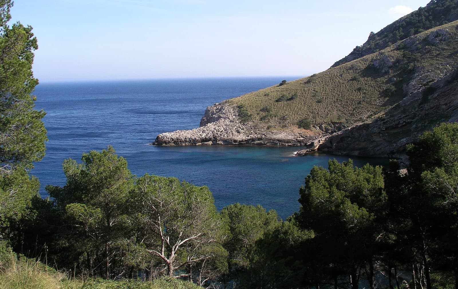

es Cingle near Canyamel Platja lies between forested slopes and the Mediterranean Sea.
Canyamel lies at the end of the Torrent de Canyamel valley. Toward the coast, the terrain opens into a sheltered bay, while forested ridges rise on both sides. This natural setting distinguishes the town from the long, open stretches of coast found in other parts of the island.
The viewpoint is especially worthwhile for travelers who want to experience Canyamel as more than just a beach resort. Those interested in landscapes gain a sense of the topography along the northeastern coastline, photographers find a subject beyond the beach perspective, and during a walk through the town, the view provides a peaceful counterpoint to the promenade and waterfront.
What to see
The bay of Canyamel
The most important impression comes from the shape of the landscape. Platja de Canyamel lies in a bay bordered on both sides by high slopes covered with pines and stone pines. Between the green hills and the open water, the coastal town appears to form the end of a valley extending inland. From the viewpoint, therefore, the focus is not on a single object but on the interplay of several different landscapes.
Down by the sea, the pale sandy beach forms the clearest transition between the settlement and the water. Depending on the light, the sea appears azure blue or turquoise green. Comparing it with the perspective directly from the shore is particularly revealing: On the beach, the water fills almost the entire field of vision, while an elevated viewpoint makes the spatial form of the bay and the slopes enclosing it easier to understand.
Cap Vermell
To the north, the bay is enclosed by Cap Vermell. The forested ridge draws the coastline away from the town and gives the view a clear boundary. The Coves d’Artà are also located in this area, although they are a separate excursion destination. For es Cingle, the cape is important primarily as a scenic frame: It shows how quickly the terrain rises again immediately behind the beach bay.
The vegetation shapes the character of the view. Instead of a completely built-up coastline, green slopes dominate large parts of the scene. It is precisely this contrast between the resort, the beach, and the forested elevation that makes the location interesting. The view is less about spectacular individual details than about Canyamel’s unusually compact geography.
Cap des Pinar
On the southern side, the coastal arc continues toward Cap des Pinar, also known as Cap des Raix. Together with Cap Vermell, this ridge forms the second natural flank of the bay. Visitors who first orient themselves by the line of the beach and then let their gaze travel across both sides can appreciate Canyamel’s sheltered location particularly well.
Costa Canyamel, a district characterized by villas and detached houses, lies on the slopes south of the town. The buildings there follow the rising terrain and differ noticeably from the more compact area around Platja. This transition is revealing for the overall landscape: Coastal vegetation, hillside development, and the sea lie close together without the surrounding ridges disappearing from view.
The Torrent de Canyamel valley
Behind the coast, the Torrent de Canyamel valley extends inland. The watercourse separates the main beach resort from the side with the villas and also explains why the landscape opens more widely here than along the rockier stretches north and south of the bay. es Cingle therefore offers more than a sea view: It is a vantage point from which the town’s position at the mouth of the valley can be understood.
Those who look for longer will quickly identify the essential lines: the beach at the end of the valley, the two forested coastal slopes, and the open Mediterranean between them. This is precisely the viewpoint’s strength. It does not reduce Canyamel to its beach but shows the town as part of a larger coastal landscape.
Visiting es Cingle
How much time visitors spend here therefore depends more on their own interests than on a sightseeing schedule. Landscape photography, changing light conditions, or carefully tracing the positions of Cap Vermell, Cap des Pinar, and Torrent de Canyamel can encourage a longer stay. No fixed visit duration can be derived from this.
For the view itself, clear visibility and pleasant weather are more important than a particular time of day. The months from May to September are considered the typical season for beach visits and outdoor activities in Canyamel, so the town can be livelier then. Outside these months, Canyamel is quieter, and milder temperatures can make a walk more pleasant. There is no reliable basis for saying at which time of day es Cingle is least crowded.
Current access times and any applicable regulations should be checked before setting out. Since the destination’s appeal lies entirely in the view, it is also worth taking a quick look at the weather and visibility. Hazy skies reduce the clarity of distant views, while a clearly visible coastline makes the bay’s distinctive setting stand out much more strongly.
Combining es Cingle with a beach day provides two very different perspectives on the same place. Down at Platja, the focus is on sand, water, and the surrounding slopes. This combination in particular makes the visit more rewarding than an isolated photo stop.
Getting there and parking
The road route from the island’s interior initially follows Ma-15 toward the northeast. It then continues via Ma-4030 and Ma-4040 to Canyamel Platja. From Palma Airport, the drive to Canyamel Platja covers 77 kilometers by road and takes around 65 minutes. From the center of Palma, it is 79 kilometers by road; the journey takes around 72 minutes and also follows Ma-15, Ma-4030, and Ma-4040.
These directions explicitly end in Canyamel Platja and not directly at the viewpoint. For the final section, es Cingle should be checked as a separate destination in the navigation system, and local route guidance should be followed. It is advisable to leave the car in the town only where signs and markings permit parking, rather than assuming that the viewpoint itself can be reached directly by car.
The landscape becomes understandable only during the final section of the journey. Approaching from Capdepera, the road draws closer to the Canyamel valley; within the town, the access routes branch toward Platja and the hillside areas. The Torrent separates the central beach area from the side toward Costa Canyamel. This terrain is also more important for finding the viewpoint than the general address “Canyamel Platja.”
Canyamel is also served by several bus stops within the town and along the neighboring stretches of coast. Since a bus stop and the viewpoint are not the same place, visitors should check in advance which stop is most convenient for their chosen access route and how the remaining section proceeds on foot. Timetables may change seasonally; checking in advance is particularly advisable for the return journey.
Bus lines to es Cingle at a glance
| Line | Route | Departures/day | First | Last |
|---|---|---|---|---|
| 423 | Font de sa Cala - Cala Rajada | 56 | 08:00 | 21:55 |
| 424 | Cala Rajada - Portocristo | 42 | 08:18 | 23:10 |
From the official GTFS feeds (TIB/SFM), no real-time data. The figures cover all stops in the town; weekend and holiday services differ — check with the operator before travelling.
Getting there by bus
Cala Provençals (14040) · 1.0 km as the crow flies
- 423Font de sa Cala - Cala Rajada · Daily
Canyamel - Coves d'Artà (14035) · 1.2 km as the crow flies
- 424Cala Rajada - Portocristo · Daily
Sa Font de sa Cala 2 (14038) · 1.9 km as the crow flies
- 423Font de sa Cala - Cala Rajada · Daily
Sa Font de sa Cala 1 (14039) · 1.9 km as the crow flies
- 423Font de sa Cala - Cala Rajada · Daily
Timetable data: official GTFS feeds (TIB/EMT), no real-time — check with the operator before travelling.
Nearby attractions
Canyamel is a quiet coastal town between Cala Ratjada and Cala Millor and belongs to the municipality of Capdepera. The present-day resort developed mainly in the late twentieth century, but its name refers to a much older episode: Sugar cane was cultivated in the valley during the fifteenth century. The Mallorcan name can be understood as “honey cane” and recalls this brief agricultural period.
Platja de Canyamel
The most obvious combination is with Platja de Canyamel. The sandy beach lies directly in the bay enclosed by forested slopes. After seeing it from es Cingle, visitors can observe from the shore how strongly perspective changes perception: The elevated overview becomes a broad expanse of water above which the two coastal slopes rise.
Despite its tourist infrastructure, the beach is known for its comparatively relaxed atmosphere. This makes it a peaceful place to finish a visit to the viewpoint without needing to travel elsewhere. Families will find a different experience on the shore than at the viewpoint; however, this does not allow conclusions to be drawn about whether access to es Cingle is suitable for small children.
Torrent de Canyamel
Torrent de Canyamel is more than a watercourse at the edge of the town. It marks the mouth of the valley and separates central Canyamel from the hillside areas of Costa Canyamel. A walk nearby helps visitors recognize the landscape that appears as a complete panorama from the viewpoint.
Cap Vermell and Coves d’Artà
Cap Vermell rises at the northern edge of the bay. The Coves d’Artà are located there and can be combined with es Cingle as a separate part of an excursion. While the viewpoint reveals the coast’s outer form, the caves are a destination in their own right. Enough time should be allowed for each place individually rather than treating them as one brief sightseeing stop.
Capdepera and Cala Ratjada are also options for continuing the trip. In such a combination, es Cingle is a viewpoint near Canyamel Platja.