
Far de Porto Cristo Lighthouse at the Harbor Entrance
.jpg)
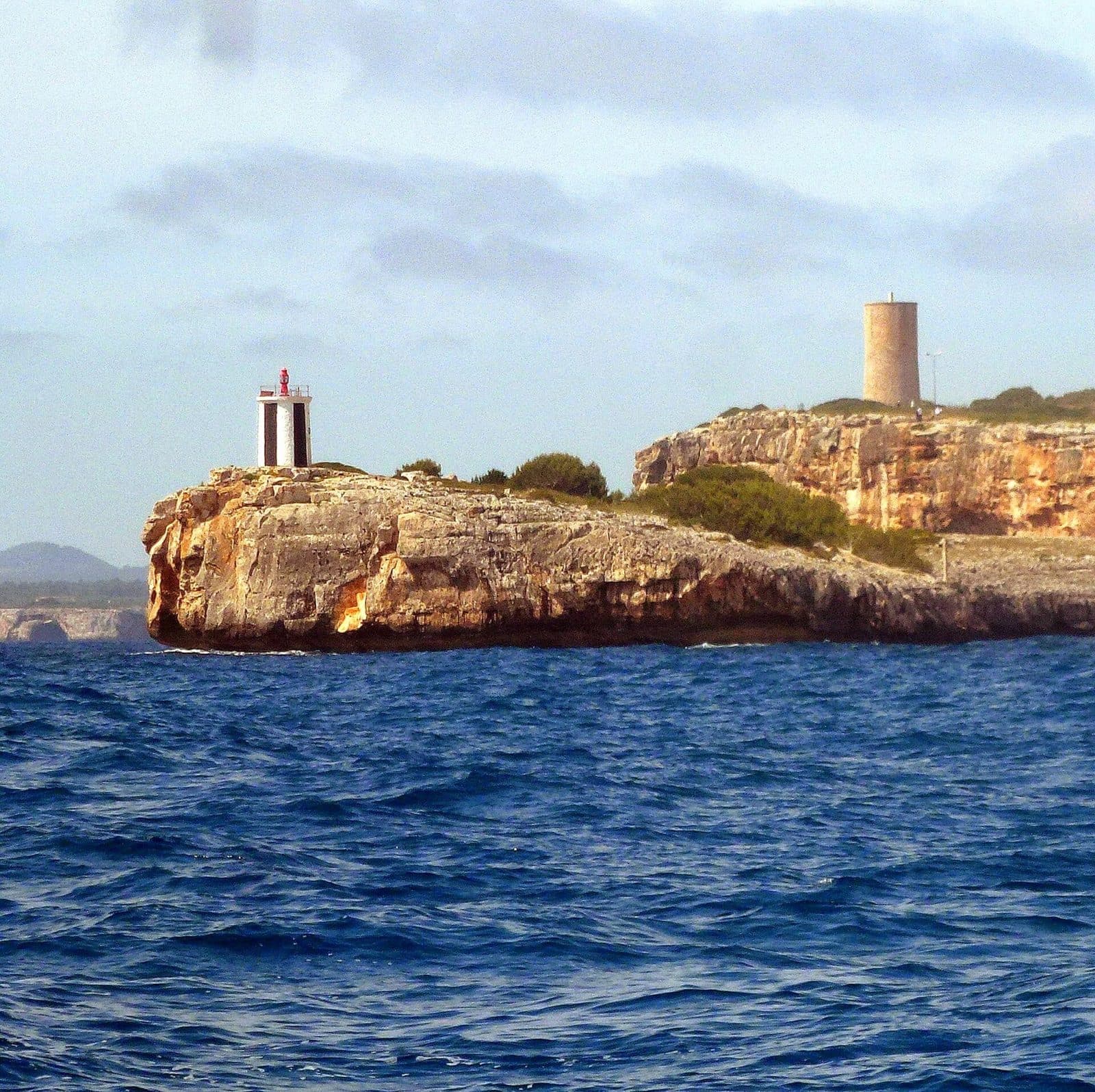
Far de Porto Cristo stands where the sheltered harbor bay widens toward the open sea. Set on a rocky headland, the lighthouse marks the entrance to Porto Cristo as a maritime landmark best discovered on a walk around the harbor.
It is precisely this location that makes a visit worthwhile. From the harbor, the route leads past boats, up a staircase, and through a quiet residential area toward the coast. Along the way, the view of Porto Cristo changes: first, you see the quays and moorings up close, then the bay as a whole, and finally the transition between harbor and sea.
The lighthouse is particularly suitable for visitors who want to see more of Porto Cristo than its famous caves. It is a destination for a manageable walk, for enthusiasts of maritime places, and for anyone who enjoys understanding how a harbor bay is laid out. Its location is the main attraction.
Far de Porto Cristo is especially worthwhile as part of a longer circular walk. The harbor, lighthouse, nearby Torre del Serral dels Falcons, and small Cala Murta can be combined into a varied exploration of the southern side of Porto Cristo. This turns a single structure into a short coastal tour offering several changes of perspective.
What to See
Even on the way there, it becomes clear why the lighthouse stands in this exact spot. The harbor of Porto Cristo lies deep within a sheltered bay. Only at its outer end does the view open beyond the rocky coast. Far de Porto Cristo occupies this transition: the harbor behind it, the sea in front, and Mallorca’s eastern coastline to the side.
Far de Porto Cristo
The lighthouse itself is primarily a functional navigational aid. Its appeal comes from the interplay of the structure, headland, and harbor entrance. Up close, it is easy to understand how precisely the location was chosen: Far de Porto Cristo does not stand somewhere along the promenade but on the projecting rock at the harbor entrance. From there, it marks the boundary between the sheltered waters of the bay and the open coast.
This geographical function is more vivid than any theoretical explanation. Looking back, your gaze follows the long harbor bay, while the outward view extends across the sea.
The Rocky Headland
The headland is the real key to the location. It projects into the water at the harbor entrance and clearly separates the different viewing directions. Approaching the lighthouse from the harbor therefore does not involve an abrupt change of scenery. The dense scene of boats, waterfront buildings, and harbor paths gradually gives way until rock and sea define the view.
This setting also makes Far de Porto Cristo more interesting for photographers than a simple close-up might suggest. The most expressive composition is often not the lighthouse alone but its position at the mouth of the bay. Depending on your standpoint, you can either include the harbor as a backdrop or emphasize the headland’s maritime character.
The View into the Harbor Bay
Looking back toward Porto Cristo reveals the bay’s elongated shape. The town extends around Cala Manacor, which is used as a natural harbor. From the outer harbor side, moorings, promenade, beach, and homes no longer appear as separate stops but as parts of a coherent coastal town.
This view distinguishes the lighthouse walk from a stroll along the central waterfront promenade. Down by the water, attention is drawn to boats, restaurants, and the immediate activity of the harbor. Farther out, the perspective opens up: the bay gains definition, and Far de Porto Cristo appears as a counterpoint to the built-up town center.
The Harbor Entrance
Two very different coastal environments meet at the harbor entrance. The sheltered harbor areas lie inside the bay, while the rocky east coast begins outside it. This transition can be observed particularly clearly from the area around the lighthouse. Boats entering and leaving follow the exact passage marked by Far de Porto Cristo.
This is the most compelling part of the experience. The lighthouse does not need to be monumental for its purpose to become clear. The view explains its role: it marks a sensitive point on the coast where navigation, harbor, and landscape come together directly.
Visiting Far de Porto Cristo
Far de Porto Cristo is not a destination to be hastily checked off after a parking stop. The visit works best as a walk from the harbor out to the headland. The route is part of the experience because the perspective over the bay changes with each section. Anyone who drives only as close as possible to the lighthouse misses this very transition.
From the Harbor to the Lighthouse
One documented route begins above the harbor area at Pas de les Drassanes and leads to Passeig d’es Cap d’es Toi. The walk initially follows the small boats there. At the end of the Passeig, the route continues up a staircase and then through a residential area toward the rocky headland.
The sequence is pleasantly varied: first the harbor atmosphere, then stairs and residential streets, and finally the coast. The path through the residential area ends at the rocky headland.
Duration and Pace of the Visit
A long stay is not necessary for the lighthouse alone. The actual duration, however, depends on where the walk begins and whether other destinations along the coast are included. Those starting at the harbor, taking photographs there, and exploring the different viewing directions at the lighthouse should not reduce the outing to a quick photo stop.
Allowing more time is especially worthwhile if the route continues to Torre del Serral dels Falcons or Cala Murta. It then becomes a short hike rather than a visit to a single sight. Far de Porto Cristo is nevertheless suitable for visitors with a tight schedule because the walk can be adjusted flexibly.
Time of Day and Crowds
There are no reliably documented visiting times when Far de Porto Cristo is generally quieter. Crowds also do not depend on the lighthouse alone, as Porto Cristo attracts many visitors because of its caves, harbor, and beach.
It therefore makes sense to plan around your own daily itinerary. Anyone wishing to explore the harbor in peace can place the lighthouse walk at the beginning of their tour through town. Those combining Porto Cristo with a cave visit can use the walk to the Far as a deliberate change of scene outdoors. Photographers should also remember that the composition’s effect depends on the viewing direction and light.
Access and Expectations
Current opening hours and admission conditions are not included in the available visitor information. As access rules may change, they should be checked before the outing. Far de Porto Cristo is mainly viewed from the outside as part of a walk; the route, exterior view, and location at the harbor entrance are the main focus.
With these expectations, Far de Porto Cristo is a rewarding destination. It does not offer a long list of attractions but instead a clear sense of place: harbor, navigation, rock, and sea. Those who take their time discover a side of Porto Cristo that is easily overlooked in the shadow of its better-known excursion destinations.
Getting There and Parking
The regional journey first leads to Porto Cristo. From Palma Airport, the town is 67 road kilometers away; the drive takes around 58 minutes via the Ma-15 and then the Ma-4020. From central Palma, the distance is 69 road kilometers. The drive takes around 65 minutes, also via the Ma-15 and Ma-4020.
These figures expressly apply to Porto Cristo, not directly to Far de Porto Cristo. The final section leads through the harbor town to the southern side of the bay. For the best visitor experience, it is advisable to leave the car in the town or harbor area and approach the lighthouse on foot.
Driving to Porto Cristo
The Ma-15 forms the main part of the connection from Palma and the airport. Porto Cristo is reached via the Ma-4020. Those arriving from the south via the Ma-4014 can follow signs in town toward the harbor or center. The final section leads through a residential area toward the rocky headland.
The destination should be clearly selected in the navigation system as Far de Porto Cristo in Mallorca. Places with the same or similar names must not be confused with the lighthouse at the harbor entrance. The decisive feature is its location on the rocky headland on the southern side of the bay of Porto Cristo.
Parking at the Harbor
One described walking route uses a parking area near the harbor and then begins above it at Pas de les Drassanes. From there, it continues via Passeig d’es Cap d’es Toi. As parking rules and markings can change, always check signs, colored curb markings, and possible time restrictions on site.
Parking at the harbor has the advantage that the route to the lighthouse is not merely a necessary walk. The tour begins directly among the harbor basins and boats before opening up the outer coastal side. Those who later want to remain in the center, at the beach, or on the promenade can continue from the same starting area.
By Bus
Bus stops in the Porto Cristo area include Coves del Drac, Platja de Portocristo, and Ctra. Son Servera. They serve different parts of the town and are not located directly on the lighthouse headland. The final section must therefore be planned as a walk through Porto Cristo and along or above the harbor.
The most suitable stop depends on the bus route used and the rest of the day’s itinerary. Platja de Portocristo is a useful reference point for starting in the central town and beach area. The stops near Coves del Drac are especially convenient when combining the lighthouse walk with a visit to the Dragon Caves.
Bus lines to Far de Porto Cristo at a glance
| Line | Route | Departures/day | First | Last |
|---|---|---|---|---|
| 401 | Cala Millor - Palma | 197 | 06:05 | 23:57 |
| A42 | Cala Bona - Aeroport | 166 | 00:02 | 23:02 |
| 427 | Cala Mendia - Portocristo | 144 | 08:00 | 22:30 |
| 424 | Cala Rajada - Portocristo | 129 | 00:05 | 23:56 |
| 425 | Cala Bona - Portocristo | 123 | 08:00 | 22:23 |
| 428 | Cala d'Or - Portocristo | 58 | 08:05 | 21:52 |
From the official GTFS feeds (TIB/SFM), no real-time data. The figures cover all stops in the town; weekend and holiday services differ — check with the operator before travelling.
Getting there by bus
Coves del Drac 1 (33018) · 0.7 km as the crow flies
- 424Cala Rajada - Portocristo · Daily
- 425Cala Bona - Portocristo · Daily
- 427Cala Mendia - Portocristo · Daily
- 428Cala d'Or - Portocristo · Daily
Platja de Portocristo (33011) · 0.8 km as the crow flies
- 427Cala Mendia - Portocristo · Daily
- 428Cala d'Or - Portocristo · Daily
Coves del Drac 2 (33017) · 0.9 km as the crow flies
- 427Cala Mendia - Portocristo · Daily
- 428Cala d'Or - Portocristo · Daily
Ctra. Son Servera 1 (33053) · 1.2 km as the crow flies
- 401Cala Millor - Palma · Daily
- 424Cala Rajada - Portocristo · Daily
- 425Cala Bona - Portocristo · Daily
- A42Cala Bona - Aeroport · Daily
Ctra. Son Servera 2 (33054) · 1.2 km as the crow flies
- 401Cala Millor - Palma · Daily
- 424Cala Rajada - Portocristo · Daily
- 425Cala Bona - Portocristo · Daily
- A42Cala Bona - Aeroport · Daily
Mestral 2 (33079) · 1.4 km as the crow flies
- 401Cala Millor - Palma · Daily
- 424Cala Rajada - Portocristo · Daily
- 425Cala Bona - Portocristo · Daily
- A42Cala Bona - Aeroport · Daily
Mestral 1 (33078) · 1.4 km as the crow flies
- 401Cala Millor - Palma · Daily
- 424Cala Rajada - Portocristo · Daily
- 425Cala Bona - Portocristo · Daily
- A42Cala Bona - Aeroport · Daily
Cala Anguila - Cala Magrana 1 (33051) · 1.9 km as the crow flies
- 427Cala Mendia - Portocristo · Daily
Cala Anguila - Cala Magrana 2 (33050) · 1.9 km as the crow flies
- 427Cala Mendia - Portocristo · Daily
Dinosaurland - Coves Hams (33046) · 2.1 km as the crow flies
- 401Cala Millor - Palma · Daily
Timetable data: official GTFS feeds (TIB/EMT), no real-time — check with the operator before travelling.
Things to See Nearby
Around the Far, Porto Cristo reveals its maritime side. The town belongs to the municipality of Manacor and lies on a deeply indented bay used as a fishing and leisure harbor. In the center, the harbor promenade, beach, and town buildings meet; at the lighthouse, by contrast, the rocky coast comes to the foreground.
Porto Cristo and the Harbor
A walking tour should not begin only at the lighthouse. The harbor provides the narrative opening: boats lie in sheltered water, paths follow the shoreline, and only farther out does it become clear how narrow the connection to the open sea appears. Far de Porto Cristo forms the logical conclusion of this movement from the inner harbor toward the entrance.
On the return journey, the walk can continue toward the center. The beach cove and waterfront promenade are located there, with restaurants and cafés concentrated along the shore. The outing therefore combines a quiet stretch of coast with the livelier heart of Porto Cristo without requiring another drive.
Torre del Serral dels Falcons
Torre del Serral dels Falcons stands near Far de Porto Cristo. The historic coastal tower is a separate structure, but its location makes it easy to include in the same walk. The lighthouse and defensive tower represent different roles along the same coast: one serves maritime navigation, while the other belongs to the historical observation and protection of the coastal area.
Visiting them together is especially appealing because the two structures do not replace one another. The Far explains the present-day harbor entrance, while the tower provides an older perspective on the exposed coastal setting. For a detailed historical account of the Torre, consult its own attraction page.
Cala Murta
The small Cala Murta is also included with the lighthouse and Torre del Serral dels Falcons in one described circular tour. It provides a scenic counterpoint to the harbor and structures. Instead of turning back immediately after the photo stop at the Far, the route can be extended along the coastal side.
Whether the cove fits into the day’s itinerary depends on fitness, weather, and the desired length of the walk. As a combination, however, it shows particularly well how quickly Porto Cristo transitions from an organized harbor environment to a rockier coastal landscape.
Coves del Drac and Coves dels Hams
Coves del Drac and Coves dels Hams are the best-known excursion destinations near Porto Cristo. They should not be considered part of the lighthouse, but they can easily be visited on the same day. After an underground tour, the route to Far de Porto Cristo offers a clear change of scene: from cave chambers and artificial lighting back outside to the harbor and coast.
Anyone combining both experiences should allow sufficient buffer time between scheduled activities and the flexible walk. The Far works better as a peaceful beginning or conclusion than as a rushed stop immediately before a reserved admission time.
The place it belongs to
Porto Cristo in the place guidePractical Information for Your Visit
Far de Porto Cristo requires less preparation than a long hike, but the walk should not be started without any planning. Stairs, residential streets, and the coastal section make it more varied than a level circuit along the central promenade. A current map view makes navigation easier, especially where the harbor path enters the residential area.
Footwear and Path Conditions
The described access route includes a staircase and a path through a residential area. Comfortable, secure footwear is therefore more suitable than beachwear alone. Anyone extending the walk beyond the lighthouse to Torre del Serral dels Falcons or Cala Murta should choose shoes for the coastal route rather than for the restaurant visit afterward.
After rain or in strong winds, extra care is advisable on exposed and rocky sections. The Far stands on a headland, not in an enclosed visitor park. Paths and possible barriers should be respected; no photograph is worth leaving marked or secured areas.
Sun and Weather
There are built-up sections around the harbor, but the lighthouse stands outside on the coast. Sun protection and drinking water are therefore sensible essentials in warm weather. Even if the stay at the Far itself is brief, the time outdoors increases considerably because of the walk there and back and any additional detours.
Wind can alter conditions at the harbor entrance. A place that feels calm in the sheltered center may be more exposed on the projecting headland. Light items should therefore be securely stored. In unsettled weather, it is advisable to plan the coastal section not as an isolated excursion but as a flexible part of the town walk that can be shortened if necessary.
With Children
Children may find the route interesting because boats, harbor basins, lighthouse, and coast follow one another along the way. Unlike a long indoor visit, it continually offers new things to observe. The staircase and rocky setting, however, require attention and age-appropriate supervision.
It is best not to present the Far as the day’s only destination but as a stop on a short discovery tour. The harbor, nearby defensive tower, and possibly Cala Murta provide variety. Children should not run ahead along the coast, particularly where paths approach rocks or water.
What Defines the Place
At Far de Porto Cristo, the location on the rocky headland at the harbor entrance is the central feature. Yet the place is worthwhile for another reason: the lighthouse sharpens your awareness of the harbor bay’s shape and the connection between Porto Cristo and the sea. As an individual attraction, it is understated; as the endpoint of the harbor path and a stop on a coastal circuit, it reveals its full impact.
Local insider tips
Take the Harbor Route
Do not drive directly as close as possible to the lighthouse: the documented route along Passeig d’es Cap d’es Toi begins among the boats. Only as you continue walking does it become clear how the sheltered harbor opens toward the sea.
Photograph More Than the Tower
The most expressive viewpoint includes the harbor entrance. Far de Porto Cristo is best understood through its location on the rocky headland; a simple close-up loses precisely this context.
Combine It with the Coastal Tower
The nearby Torre del Serral dels Falcons can be included in the same walk. This places a historic coastal watchtower and a navigational aid on one circular route without requiring another drive between them.
Continue to Cala Murta
Anyone wanting more than a quick photo stop can continue the coastal circuit to the small Cala Murta. The documented tour connects the harbor, Far de Porto Cristo, Torre del Serral dels Falcons, and the cove.