
Punta des Pagell – Porto Cristo Viewpoint
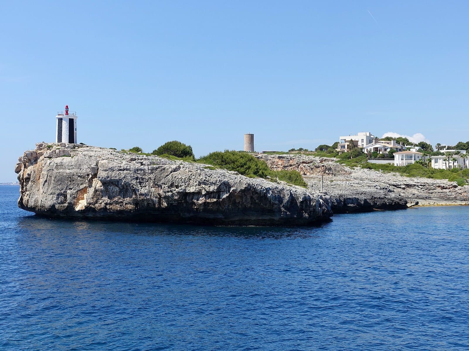

Punta des Pagell draws attention to a side of Porto Cristo that is easily overlooked between the beach, harbor promenade, and well-known excursion destinations. The viewpoint lies on the coast of this town in eastern Mallorca. The location itself is the main attraction: a spot at the edge of the Mediterranean from which Porto Cristo and its coastal landscape can be seen differently than from down by the water.
That is precisely where its appeal lies. While life in the resort town is concentrated around the beach and harbor bay, Punta des Pagell provides some distance. The visit suits travelers who enjoy exploring on foot, observing coastal formations, or seeing Porto Cristo as more than just a starting point for the famous caves nearby. The viewpoint is also suitable as a brief break between the beach, harbor, and another excursion destination.
Punta des Pagell should not, however, be mistaken for a conventional attraction visited on a fixed tour. What you can primarily expect is a place from which to look out over the sea and coast. Anyone who enjoys photography, wants to understand the spatial setting of a harbor, or simply wishes to spend some time by the water will appreciate this perspective.
What to See
The crucial change in perspective begins where Porto Cristo no longer appears merely as a sequence of beach, promenade, and houses. At Punta des Pagell, the town's location on Mallorca's east coast becomes the true focus of the visit. The viewpoint is mapped as such; its value comes not from elaborate architectural staging but from its position at the edge of the coast.
The viewpoint itself
At Punta des Pagell, looking is the main activity. The impression changes with your position: a few steps can determine whether the coast, open sea, or buildings of Porto Cristo dominate the view. This simplicity is an advantage when the visit is understood in the right way. The place requires neither lengthy preparation nor a detailed sightseeing plan but rewards attention to lines and transitions: the boundary between land and water, Porto Cristo's position on an indented coastal bay, and the contrast between the tourism-oriented town and the open Mediterranean horizon.
Punta des Pagell is therefore less a single photo subject than a place from which the surroundings can be put into context. Anyone who has already walked along the beach or promenade below will better understand from this altered perspective how closely Porto Cristo is connected to its natural harbor setting. The town is shaped not by its buildings alone but by the interplay of bay, coast, and sea.
The coastal side
On the seaward side, the view opens beyond the sheltered town. This creates the strongest contrast with the beach promenade: below, attention is drawn to boats, the beach, and restaurants, while at the viewpoint it shifts to the broader coastal landscape. Depending on visibility and weather, the horizon may stand out clearly, or the surface of the sea itself may become the most striking element.
Photographers in particular should not treat the spot merely as a place for a quick snapshot. A composition dominated by the sea has a different effect from one that includes part of the coastline or Porto Cristo's buildings. The viewpoint allows visitors to switch between these visual ideas without prescribing a particular subject. Here, the sea is not the backdrop to a structure but the main attraction. Punta des Pagell is therefore especially worthwhile for anyone looking for a peaceful observation point on the east coast.
Porto Cristo from a coastal perspective
Porto Cristo belongs to the municipality of Manacor and is also known as Port de Manacor or Es Port. The town lies in the Llevant region and has been strongly shaped by tourism. Nevertheless, its layout is still defined by the harbor bay: the beach, waterfront promenade, and harbor are situated where the coast forms a sheltered inlet.
From Punta des Pagell, the overall panorama is not the only point of interest; visitors can also observe how the built-up town follows the shape of the coast. Those who initially know Porto Cristo from its streets and promenade gain a complementary perspective here. The Punta reveals that the town is simultaneously a beach destination, a harbor, and part of a ruggedly indented east coast.
This also makes the viewpoint a suitable starting point. After looking down from above or from the coastal edge, the beach and harbor can be explored with a greater awareness of their setting. Conversely, visiting after a walk beside the water provides a spatial conclusion: the town you have just crossed now appears before you as a coherent coastal scene.
Visiting
A visit to Punta des Pagell centers on views of Porto Cristo, the coast, and the sea.
Time to enjoy the view
A visit can be brief if you only want to look out over the sea. Anyone taking photographs, examining the shape of the coast more closely, or using the visit as a break will probably want to stay longer. A fixed sightseeing duration would be misleading because it depends almost entirely on personal interest and the rest of your route through Porto Cristo.
It makes sense not to treat Punta des Pagell as an isolated destination requiring a long journey within the town but as part of a walk. The beach, harbor area, and viewpoint reveal different sides of the same coastal town and together provide a more complete picture than any of these places alone.
Light and weather
At a viewpoint, the weather shapes the experience more strongly than it does at an indoor attraction. Clear visibility makes coastlines and the horizon stand out more distinctly; under overcast skies, the water's surface and clouds may instead dominate the scene. A cloudy day does not automatically make the detour unrewarding, but it does change its character.
For photographs, it is worth checking different angles on site rather than shooting only toward the sea. Porto Cristo lies on the east coast, and a travel report from the town describes sunrise over the cliffs on the opposite side of the harbor. This does not guarantee a particular view every day, but it does provide a good reason to consider visiting in the morning.
Access without a conventional visitor program
No fixed opening hours are recorded for Punta des Pagell. Nor is there reliable information about an admission fee. Since access and local regulations can change, checking the latest situation immediately before visiting is recommended. This is particularly important when heading specifically to the viewpoint rather than simply including it in a walk.
Punta des Pagell is primarily a viewpoint. Anyone looking for exactly that will find it an uncomplicated addition to Porto Cristo; visitors expecting a sightseeing program lasting several hours should combine the detour with other destinations in the town.
Getting There
The journey from farther afield initially leads to Porto Cristo. From Palma de Mallorca Airport, the road distance to the town is 67 kilometers. The drive takes around 58 minutes and follows the Ma-15, then the Ma-4020. These figures explicitly apply only as far as Porto Cristo, not directly to the viewpoint.
From central Palma, the road distance to Porto Cristo is 69 kilometers. Allow around 65 minutes for the route via Ma-15 and Ma-4020. Here too, the reliably documented route ends in the town. The final section to Punta des Pagell follows the local road network and should be completed using up-to-date navigation.
Driving to Porto Cristo
The Ma-15 is the main route from Palma toward Manacor and the east of the island. From there, the Ma-4020 continues to Porto Cristo. Anyone traveling from Palma or the airport should therefore first select the town as an intermediate destination and only navigate to Punta des Pagell after arrival. This makes it clear which part of the journey is covered by the reliable driving data.
By bus
Several bus stops serve Porto Cristo, including stops by the beach, near the Coves del Drac, and on the road toward Son Servera. Which one is most convenient for the specific walking route depends on the service used that day and the planned itinerary. The available data does not list a dedicated stop named directly after Punta des Pagell.
A two-stage approach is therefore recommended when planning a journey by public transport: first choose a suitable connection to Porto Cristo, then check the local walking route to the viewpoint. Anyone already planning to visit the beach, promenade, or caves can use a suitable stop for those destinations as the starting point and incorporate the Punta into a longer walk.
Bus lines to Punta des Pagell at a glance
| Line | Route | Departures/day | First | Last |
|---|---|---|---|---|
| 401 | Cala Millor - Palma | 197 | 06:05 | 23:57 |
| A42 | Cala Bona - Aeroport | 166 | 00:02 | 23:02 |
| 427 | Cala Mendia - Portocristo | 144 | 08:00 | 22:30 |
| 424 | Cala Rajada - Portocristo | 129 | 00:05 | 23:56 |
| 425 | Cala Bona - Portocristo | 123 | 08:00 | 22:23 |
| 428 | Cala d'Or - Portocristo | 58 | 08:05 | 21:52 |
From the official GTFS feeds (TIB/SFM), no real-time data. The figures cover all stops in the town; weekend and holiday services differ — check with the operator before travelling.
Getting there by bus
Platja de Portocristo (33011) · 0.5 km as the crow flies
- 427Cala Mendia - Portocristo · Daily
- 428Cala d'Or - Portocristo · Daily
Coves del Drac 1 (33018) · 0.7 km as the crow flies
- 424Cala Rajada - Portocristo · Daily
- 425Cala Bona - Portocristo · Daily
- 427Cala Mendia - Portocristo · Daily
- 428Cala d'Or - Portocristo · Daily
Ctra. Son Servera 1 (33053) · 0.8 km as the crow flies
- 401Cala Millor - Palma · Daily
- 424Cala Rajada - Portocristo · Daily
- 425Cala Bona - Portocristo · Daily
- A42Cala Bona - Aeroport · Daily
Ctra. Son Servera 2 (33054) · 0.8 km as the crow flies
- 401Cala Millor - Palma · Daily
- 424Cala Rajada - Portocristo · Daily
- 425Cala Bona - Portocristo · Daily
- A42Cala Bona - Aeroport · Daily
Coves del Drac 2 (33017) · 0.8 km as the crow flies
- 427Cala Mendia - Portocristo · Daily
- 428Cala d'Or - Portocristo · Daily
Mestral 2 (33079) · 1.0 km as the crow flies
- 401Cala Millor - Palma · Daily
- 424Cala Rajada - Portocristo · Daily
- 425Cala Bona - Portocristo · Daily
- A42Cala Bona - Aeroport · Daily
Mestral 1 (33078) · 1.1 km as the crow flies
- 401Cala Millor - Palma · Daily
- 424Cala Rajada - Portocristo · Daily
- 425Cala Bona - Portocristo · Daily
- A42Cala Bona - Aeroport · Daily
Dinosaurland - Coves Hams (33046) · 1.9 km as the crow flies
- 401Cala Millor - Palma · Daily
Cala Anguila - Cala Magrana 1 (33051) · 2.0 km as the crow flies
- 427Cala Mendia - Portocristo · Daily
Cala Anguila - Cala Magrana 2 (33050) · 2.1 km as the crow flies
- 427Cala Mendia - Portocristo · Daily
Timetable data: official GTFS feeds (TIB/EMT), no real-time — check with the operator before travelling.
Nearby
Porto Cristo's commonly used names already reflect its harbor character: alongside the Spanish name, Port de Manacor and Es Port are also used. The town belongs to Manacor but lies directly on Mallorca's east coast in the Llevant region. To visitors, it feels less like a suburb of the inland city than an independent coastal town whose everyday life and tourism center around the bay, beach, and harbor.
Porto Cristo
After visiting the viewpoint, a walk through Porto Cristo is an obvious choice. The waterfront promenade and beach reveal the sheltered inner side of the bay, while Punta des Pagell directs the view farther outward toward the coast and sea. This shift makes the combination worthwhile: below, the panorama once again becomes a living place with paths, boats, a swimming area, and restaurants.
Porto Cristo is shaped by tourism but has retained the basic layout of a harbor town. Anyone who arrives only to visit a well-known attraction and then immediately continues elsewhere may easily overlook how strongly the bay shapes the town. The viewpoint provides a good introduction without requiring much time itself.
Beach and harbor promenade
Porto Cristo's beach lies sheltered within the bay and can easily be combined with Punta des Pagell. Beside the water, the view turns inward toward the swimming area and the opposite sides of the bay; at the viewpoint, it opens up again. The two perspectives complement each other without requiring a packed sightseeing schedule.
The promenade is also a natural continuation. This is where Porto Cristo's visible daily life unfolds, while the Punta is more about gaining an overview. Anyone visiting the viewpoint in the morning can then walk along the harbor. For a later detour, the reverse order is a good option.
Coves del Drac and Coves dels Hams
The Coves del Drac and Coves dels Hams are among the best-known destinations near Porto Cristo and offer a clear contrast to Punta des Pagell. Combining them therefore creates variety, although the individual destinations should not be confused with one another. Punta des Pagell is a viewpoint near Porto Cristo. Anyone traveling by bus can include a stop in the Coves del Drac area when planning the route.
Coves Blanques
At the end of the beach, the Coves Blanques lie at sea level. They are also associated with the name Cova de Patró Pelat and form part of Porto Cristo's local history. For a walk encompassing the viewpoint, beach, and harbor, they provide another connection to the rocky coastal landscape without needing to become a major sightseeing stop of their own.
Punta des Pagell and Coves Blanques illustrate two different ways of experiencing the coast: once from a distance as a view, and once up close beside the rock and water's edge. This sequence in particular makes a walk through Porto Cristo more vivid than simply spending time on the promenade.
Local insider tips
Consider the morning
Porto Cristo lies on the east coast, and a travel report describes sunrise over the cliffs on the harbor side. An early detour is therefore a natural choice for clear morning light and a peaceful walk around the town.
Plan it as a town circuit
Punta des Pagell works best as part of a walk including the beach and harbor promenade. This creates a sequence of the sheltered bay, life beside the water, and the viewpoint's more open coastal perspective.
Navigate to Porto Cristo first
The reliable driving data ends in Porto Cristo. Only after arriving there should the final section to Punta des Pagell be checked using up-to-date navigation, rather than treating the main driving time as an arrival directly at the viewpoint.
Do not confuse it with n’Amer
Punta des Pagell near Porto Cristo is not Punta de n’Amer between Sa Coma and Cala Millor. Anyone searching for images or routes should pay attention to the full name and the location Porto Cristo.
Change the direction of your shot
Do not photograph only the open sea: the Punta is particularly useful for understanding Porto Cristo's position on the harbor bay. An image including the coast or the edge of the town therefore often tells more than a simple horizon shot.