
Far de sa Creu: The Lighthouse at Port de Sóller Harbor Entrance
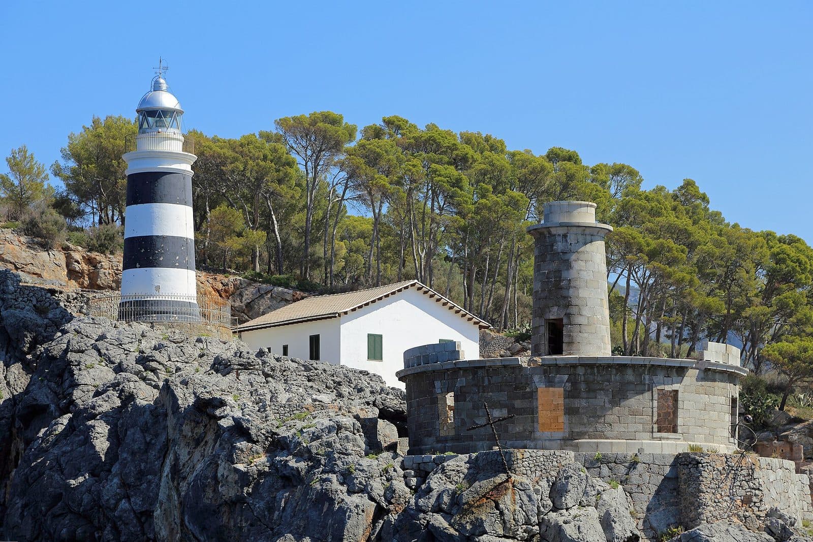

Far de sa Creu stands on a projecting headland on the eastern side of the harbor entrance to Port de Sóller. From here, its light marks the transition between the open sea and the sheltered bay. Those who view the harbor only from the promenade usually see the lighthouse as a distant detail. Only from a closer perspective does it become clear that this site preserves not just a tower, but a small chapter of Mallorcan maritime history.
Its appeal lies above all in the interplay between the structure and its setting. Far del Cap Gros stands on the opposite side of the harbor entrance; together, the two beacons frame the approach to Port de Sóller. Far de sa Creu is more than a picturesque landmark. Its white signal continues to aid navigation and recalls that the bay was an important gateway to the Sóller Valley long before tourism developed here.
The juxtaposition of old and new is particularly interesting. The first lighthouse was built in the 19th century but stood in a problematic location. It was later replaced by a new tower. The remains of its predecessor have been preserved and are visible from outside. At this single site, visitors can therefore see how closely the history of navigational lights is connected to wind, surf, and the geological characteristics of a coastline.
A visit suits travelers who appreciate maritime architecture, photography, and quiet viewpoints. The experience comes from seeing the exterior, taking in the setting above the eastern harbor entrance, and observing the nautical function that Far de sa Creu continues to fulfill today.
History and Significance
The most unusual episode in the history of Far de sa Creu began with a planning error. The original lighthouse was built on Punta de sa Creu in 1864 and entered service there. Its location, however, was too close to a feature known as a Bufador: a natural opening or coastal channel through which air and water can be forced upward with considerable power during rough seas. What appeared to be a suitable site on a calm map proved problematic in stormy weather.
The First Lighthouse from 1864
The old Far de sa Creu entered service in 1864. Its purpose was clear: ships needed to identify the eastern boundary of the harbor entrance and use a reliable signal for orientation in darkness or poor visibility. At a bay whose opening lies between two coastal headlands when approached from the sea, such a beacon has immediate practical importance.
Its proximity to the Bufador, however, exposed the structure to the effects of the surf. During a storm, the sea could not only crash against the rocks but also force water and air through the natural opening toward the lighthouse. In the long term, the location was unsuitable. The old structure was abandoned but not removed entirely. Its remains were left on the coast and today account for the key difference between Far de sa Creu and many other lighthouse stations: here, the failed first solution can still be seen beside its successor.
The Present Lighthouse
The current tower entered service in 1945 and replaced the installation from 1864. The lighthouse station itself therefore dates back to the 19th century, while the active structure seen today comes from a later period. This distinction explains why different years may be associated with Far de sa Creu: they refer respectively to the start of lighthouse operations on Punta de sa Creu and to the current tower.
Despite technological changes, its function has not fundamentally altered. The beacon continues to mark the eastern side of the approach to Port de Sóller. Opposite it, Far del Cap Gros provides orientation on the other side of the entrance. Together, the two lights form an easily understood nautical pair: the route into the harbor opens between them.
A Working Technical Monument
Far de sa Creu is not a decommissioned memorial. Its light is powered electrically, uses a belt lens, and displays a white flash every 2.5 seconds. These figures are not merely technical footnotes. They describe precisely what the tower was built to do: to be identified clearly at sea and distinguished from other signals.
The juxtaposition of the ruin and the active light gives the site particular historical depth. The old structure tells of the difficulty of adapting to an exposed coast, while the new one reflects the continuing need for safe marking. Far de sa Creu thus documents not only a construction history but also the learning process behind reliable maritime infrastructure.
What to See
Even from a distance, it is clear that Punta de sa Creu does not represent a single historical phase. The old and new lighthouses embody two attempts to make the same coastal point usable for navigation. Visitors should therefore look not only for the active tower but also for the externally visible remains of its predecessor.
The Active Tower
The present Far de sa Creu has a tower height of 13 meters. Because of its elevated position on the headland, the light stands 35 meters above the sea. This difference between tower height and focal height demonstrates how important the terrain itself is to the range of a beacon: the optics are raised above the water not only by the tower but also by the natural elevation of Punta de sa Creu.
The actual beacon and its belt lens sit in the upper section. For visitors, the regular light characteristic is particularly interesting. After dark, a white flash appears at intervals of 2.5 seconds. Seafarers recognize a lighthouse not only by its position but also by this kind of individual rhythm. In a sense, Far de sa Creu can therefore be heard without making a sound: its beat is written into the night with light.
In daylight, the structure appears more understated. Its location then becomes more prominent than its technology. The tower stands on the eastern projection of the harbor entrance, making its purpose immediately legible from the topography. The sheltered bay of Port de Sóller lies on one side, while the open coastal waters begin on the other. The signal stands precisely at this threshold.
The Remains of the Old Far de sa Creu
The remains of the first lighthouse are visible from outside. They should not be overlooked as incidental outbuildings, as they tell the more compelling half of the story. The structure from 1864 stood too close to the Bufador and ultimately had to be abandoned. Its surviving sections therefore mark the original site and make the threat posed by the surf spatially comprehensible.
A Bufador is not a technical installation but a natural feature of a rocky coastline. In suitable sea conditions, water and air are forced through cavities or openings. The fact that a lighthouse was built directly beside such a feature explains why the first installation did not endure despite its important purpose.
The old installation is primarily an exterior sight. Its walls and structures can be viewed in relation to the coast and the replacement tower; the remains are visible from outside. This unmediated juxtaposition particularly rewards close observation. Only when both generations are viewed together does Far de sa Creu reveal itself as a historical site rather than merely a photographic subject.
The Harbor Entrance
The most important “space” around the lighthouse is the entrance to Port de Sóller itself. Looking across the water, Far del Cap Gros stands on the opposite side. The two lighthouses mark opposing sides of the same passage and make the shape of the bay especially clear. Boats entering or leaving the harbor travel between these two points of orientation.
From Punta de sa Creu, visitors therefore see not only a coastal landscape but also a functioning transport route on the water. The position of the tower is explained anew by every arriving or departing vessel. Those familiar with maritime structures only as romantic silhouettes gain a clear impression here of how precisely their sites are chosen and why a light signal remains in operation even in the age of modern navigation.
Light Signal and Optics
The technical equipment remains inside the active system, but its effect can be seen from outside. The belt lens focuses the electric light, while the characteristic consists of a white flash every 2.5 seconds. Unlike a continuous light, this sequence provides a distinct identity. On nautical charts and in lists of lights, it can be assigned to Far de sa Creu.
The shift in perspective is an interesting part of the visit: during the day, visitors observe the architecture and coastline; after dark, the lighthouse’s actual language emerges. A quiet structure once again becomes an active navigational marker.
Visiting Far de sa Creu
It makes sense to approach the stay as a focused exterior visit. The active tower usually catches the eye first; it is then worth comparing it with the remains of the old lighthouse before looking across the harbor entrance toward Far del Cap Gros.
Viewing the Exterior
Allow enough time for unhurried observation. The key details are not found in extensive displays but in the relationships between the structures: Where did the old tower stand, where is its successor, how does the entrance open, and what role does the elevated terrain play in the focal height? Following these questions on site offers more than taking a quick souvenir photograph.
It is documented that the remains of the old lighthouse can be viewed from outside. The active Far de sa Creu remains primarily an operational navigational structure. Current access conditions may change and should be checked before setting out, especially if the lighthouse is intended to be the sole destination of an excursion.
Daylight and Darkness
The two construction phases are easiest to compare in daylight. The outlines of the ruin, the present tower, and the rocky setting on Punta de sa Creu can then be viewed together. Daylight is also the obvious choice for photographs of the harbor entrance and the opposite side.
After dark, the focus changes. The characteristic of the active light becomes visible: a white flash every 2.5 seconds. Anyone observing the lighthouse at this time from a suitable, safe position experiences not just a structure but its continuing purpose. A visit in darkness, however, requires particular attention to paths, terrain, and current access conditions.
Time Required and Character of the Visit
It is difficult to recommend a fixed amount of time for Far de sa Creu. Those who simply wish to see and photograph the tower can keep the visit brief. Those who want to understand the old installation, observe the harbor entrance, and watch vessel movements will stay longer. The time required therefore depends more on an interest in photography and seafaring than on the size of an accessible interior.
As a destination in its own right, the lighthouse particularly appeals to those who consciously appreciate technical monuments and coastal sites. For a more varied excursion, combine it with Port de Sóller. The quiet exterior view on Punta de sa Creu then becomes part of a day encompassing the harbor, bay, promenade, and the historic transport landscape of the Sóller Valley rather than remaining isolated.
Getting There and Parking
The stated road routes lead as far as El Port, meaning Port de Sóller, and not directly to the lighthouse. This distinction is important: Far de sa Creu stands on the eastern coastal projection at the harbor entrance. For the final section, check the current route, possible vehicle restrictions, and actual on-site access.
From Palma Airport
The road distance from Palma Airport to El Port is 36 kilometers. The journey takes around 48 minutes and initially follows the Ma-20, then the Ma-11 toward Sóller and Port de Sóller. At the end of the route, travelers reach the harbor town, from which the eastern headland must be approached separately.
For planning purposes, the lighthouse should therefore not be equated with a parking area directly beside a freely accessible main entrance. Those arriving by car should first head toward Port de Sóller and check the appropriate onward route there. Punta de sa Creu is the site of an active navigational aid.
From Central Palma
From central Palma, the road distance to El Port is 31 kilometers. The journey takes around 52 minutes and follows the Ma-11. This figure also ends in Port de Sóller; it does not describe the travel time directly to Far de sa Creu.
On a first visit in particular, it is advisable to use the harbor as a point of orientation. From there, the lighthouse’s location at the eastern entrance can already be understood geographically. Before continuing, check how far current vehicle access extends and where the car may legally be parked. Reliable parking conditions directly beside the structure may differ from the general parking situation around the harbor.
By Public Transport
The Port de Sóller bus stop is located in the harbor town and provides a suitable starting point for a visit without a private vehicle. It is not, however, located at the lighthouse itself. After arrival, the final section toward the eastern side of the harbor must be organized separately. Travelers should therefore check not only the name of the destination but also the specific route to Punta de sa Creu.
The advantage of traveling to Port de Sóller is that it is easy to combine with other activities. The lighthouse can be paired with time at the harbor without making the entire excursion dependent on direct access to the structure. This keeps the visit worthwhile even if current access rules permit viewing only from a greater distance.
Bus lines to Far de sa Creu at a glance
| Line | Route | Departures/day | First | Last |
|---|---|---|---|---|
| 204 | Port de Sóller - Palma | 76 | 00:40 | 23:30 |
| 203 | Valldemossa / Deià | 58 | 06:05 | 23:15 |
| 232 | Port de Sóller - Fornalutx | 58 | 07:05 | 21:15 |
| 231 | Port de Sóller - Alcúdia | 8 | 09:00 | 20:35 |
From the official GTFS feeds (TIB/SFM), no real-time data. The figures cover all stops in the town; weekend and holiday services differ — check with the operator before travelling.
Getting there by bus
Port de Sóller (61027) · 1.0 km as the crow flies
- 203Valldemossa / Deià · Daily
- 204Port de Sóller - Palma · Daily
- 231Port de Sóller - Alcúdia · Daily
- 232Port de Sóller - Fornalutx · Daily
Timetable data: official GTFS feeds (TIB/EMT), no real-time — check with the operator before travelling.
Nearby Attractions
Port de Sóller extends around a sheltered, horseshoe-shaped bay. Far de sa Creu occupies its eastern outlet to the sea and thereby explains an essential part of the town’s layout. From the waterfront, the lighthouse appears as the endpoint of the coastline; from its side, the harbor can be understood as a protected space behind a comparatively narrow entrance.
Port de Sóller
For many years, the harbor was the Sóller Valley’s natural gateway to the sea. Before modern road and rail links made travel across the mountains easier, it played a decisive role in trade and transport. Today, the bay is shaped by harbor facilities, a promenade, and beaches. Within this lively setting, Far de sa Creu is a reminder that Port de Sóller remains a working harbor rather than merely a waterfront backdrop.
A walk around the bay offers an opportunity to locate the lighthouse from a distance first. From changing points along the shore, the relationship between the tower, harbor entrance, and opposite headland shifts. This gradual approach helps explain its nautical function more effectively than an isolated close-up view.
Far del Cap Gros
Far del Cap Gros stands on the other side of the harbor entrance. The two beacons should be understood as counterparts, even though they are separate excursion destinations. Far de sa Creu marks the eastern side of the approach, while Far del Cap Gros marks the opposite side. Those who identify both positions in the landscape suddenly see the bay through the eyes of an arriving ship.
For an excursion, it is enough to place Far del Cap Gros in context from a distance; an extensive second lighthouse visit is unnecessary. Looking from one light to the other makes it especially clear how navigational markers work as a system. Their importance arises not only from each individual tower but also from its position, characteristic, and relationship to the shape of the coast.
Sóller and the Historic Railway
The harbor can be combined with the town of Sóller in the valley. The historic tram connects Port de Sóller with Sóller, while the well-known train continues the link to Palma. In central Sóller, Plaça de sa Constitució, the church of Sant Bartomeu, the historic railway station, and modernist architecture are all close together. These sights do not have to become an intensive sightseeing schedule; the journey between the harbor and the valley alone adds the region’s land-based history to the lighthouse visit.
The maritime museum also fits thematically with Far de sa Creu. While the lighthouse makes navigation at the harbor entrance visible, a museum visit provides broader context for the town’s seafaring history. Those who prefer nature and activity will also find opportunities around Port de Sóller for hiking, boat trips, and relaxing beside the bay.
The place it belongs to
El Port (Port de Sóller) in the place guidePractical Visitor Information
Far de sa Creu is most rewarding when expectations match the character of the site. It is an active navigational aid on a coastal projection, accompanied by the externally visible remains of its predecessor. Visitors should not assume that it is a developed lighthouse museum with reliably accessible interiors.
Access and Current Conditions
Opening hours and admission details have not been reliably recorded. It is therefore advisable to check current access information before visiting. This applies especially to travelers who specifically want to reach the structure itself. Although the tower can be seen from various points nearby, visibility does not automatically mean that every path, area, or part of the building is open to the public.
Viewing the exterior should be understood as the core of the visit. The old lighthouse is interesting because of its surviving remains, while the present one stands out for its location and active light signal. Visitors who arrive without expecting an interior tour can focus more fully on what truly defines this site: two construction phases, a challenging rocky coastline, and its clearly recognizable function at the harbor entrance.
Footwear and Weather
Punta de sa Creu lies on a projecting coastal headland; weather, sea conditions, and visibility can greatly alter the impression of the site. In unfavorable conditions, keep away from exposed rock edges and areas that may be reached by the surf. The historic Bufador itself is a reminder of the forces at work here during stormy seas.
For observations after dark, safe navigation on the return route is also important. The lighthouse beam serves shipping and is not a substitute for lighting along a visitor path.
Photography with Context
The most meaningful composition is not necessarily the closest shot of the present tower. Far de sa Creu becomes more compelling when the old and new lighthouses appear together or in relation to the harbor entrance. Far del Cap Gros on the opposite side can also be included in the composition. This allows the photograph to tell the story of the site’s function rather than merely showing an individual building.
In daylight, the architecture and coastline take center stage. In darkness, by contrast, the white flash every 2.5 seconds can be observed. For photography or extended waiting, always choose a safe and permitted position. Barriers and operational areas must be respected because, despite its historical importance, Far de sa Creu remains part of the maritime infrastructure.