
Port de Sóller: Natural Harbor, Promenade and Historic Tram
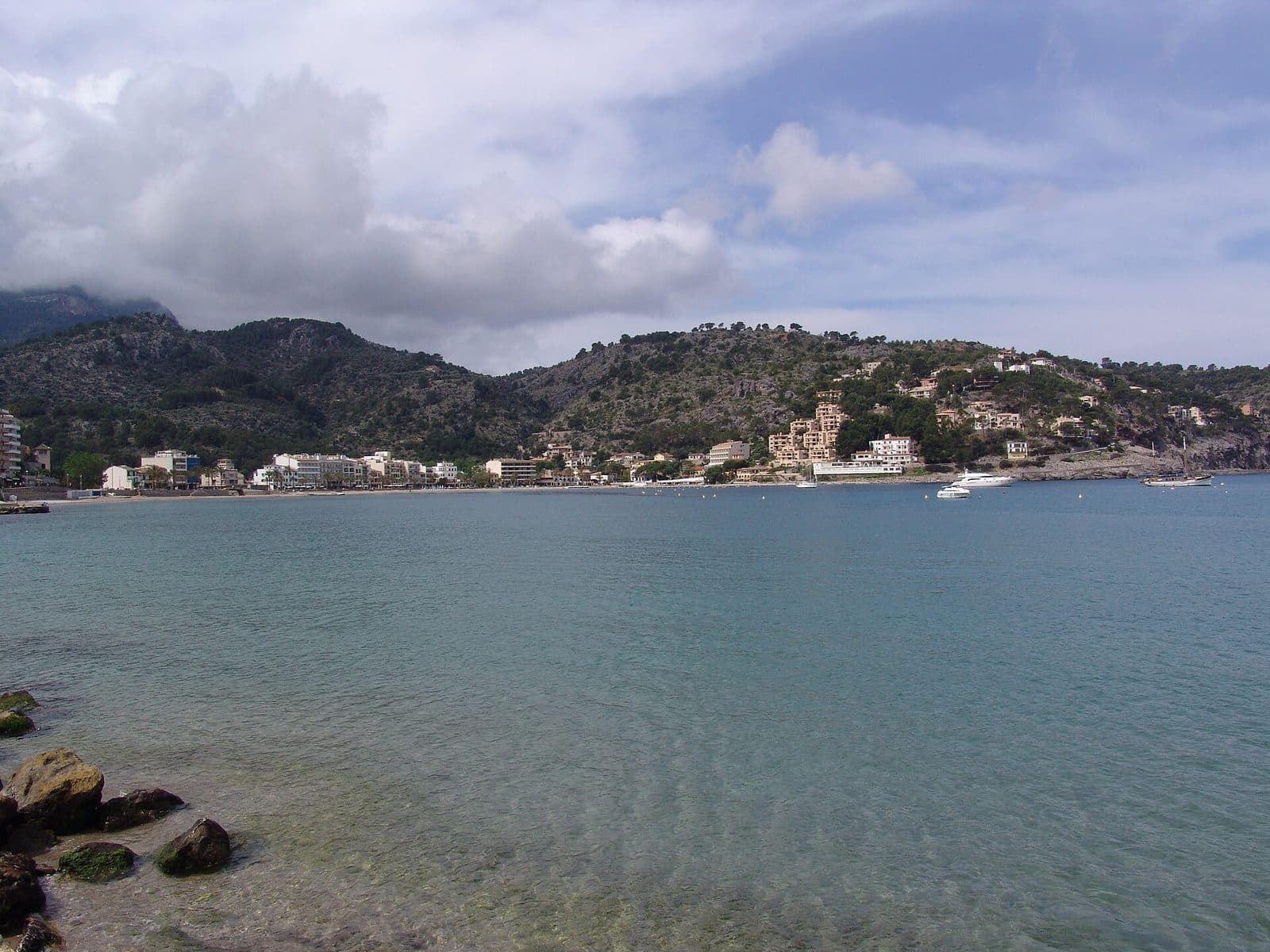

Port de Sóller opens onto the sea between the steep slopes of the Serra de Tramuntana. The sheltered natural harbor, the almost enclosed bay, and the mountains rising immediately behind it create a landscape that reveals itself as soon as you arrive: boats lie off the waterfront, the historic tram runs along the promenade, and on the opposite side, en Repic beach stretches through the southern part of the bay.
The attraction here is not a single building, but the interplay of harbor basin, coastal town, and transport history. For a long time, Port de Sóller was the maritime gateway to the secluded valley of Sóller. This role can still be clearly seen today in the harbor facilities, the settlement around the bay, and the tram connecting the port with Sóller.
A visit suits travelers who enjoy walking by the water, appreciate historic transport, or want to experience the Tramuntana beyond its mountain roads and hiking trails. The harbor also works well with a beach break or as a relaxing end to an excursion to Sóller. Even a short stay along the promenade provides a compelling impression; those who explore the entire bay discover much more than the familiar postcard view.
Its special appeal lies in the changing perspectives: maritime life takes center stage at the quay, the broad curve of the bay dominates at the beach, and from the elevated sides of the harbor it becomes clear how closely the mountains surround the town. Between them, the tram runs through the streets—not as a museum piece, but as a connection still used today.
History and significance
The history of Port de Sóller begins with its location. On Mallorca’s rugged northwest coast, the Badia de Sóller provides rare natural shelter for ships. Between Andratx and Pollença, it is considered the only protected harbor along a coastal section around 80 kilometers long. For the valley behind the mountains, this opening to the sea was therefore far more than a suitable anchorage.
The maritime gateway to the Sóller valley
Goods from the valley traveled through the port to France, Valencia, and Barcelona. Olive growing, horticulture, and later textile production shaped the municipality’s economy; agricultural produce and manufactured goods could be shipped through Port de Sóller. The maritime connection was particularly valuable because the Serra de Tramuntana made the overland route to Palma difficult.
However, the harbor brought more than trade and contacts. In the early modern period, pirate raids threatened the coast and the valley. Its exposed position by the sea was both an economic opportunity and a point of entry. This tension shaped the historical importance of the sheltered bay.
Harbor facilities and a growing settlement center
The older settlement center developed on the northeastern side of the bay, sheltered by the Racó de Santa Caterina peninsula and close to the mouth of a torrent. The parish church of Sant Ramon de Penyafort also stands there. The harbor facilities are based on expansions dating from the 18th century; the port remained the center of the town even as its economic and tourist uses changed.
The present-day townscape developed gradually around the bay. Port de Sóller was initially concentrated more strongly on the harbor side. Later, development spread along the southern and eastern shores and beyond en Repic beach. Walking along the promenade therefore also takes visitors through different stages in the coastal town’s development.
The tram as a turning point
Since 1913, the tram has connected Sóller with its harbor. It strengthened the link between the valley, shaped by agriculture and commerce, and its seaport. Its route runs from Sóller through the plain characterized by citrus groves and reaches the bay on the en Repic side.
The tram shifted part of the town’s development southward. Today, it is the most visible historic link between town and harbor. The fact that its carriages travel through the streets past cafés, the promenade, and the beach makes the former infrastructure tangible. Port de Sóller is therefore not a preserved harbor scene, but a place whose history remains in motion.
What to see
The first view usually takes in the entire curve of the bay. To truly understand Port de Sóller, however, it is worth seeing it from more than one point. The harbor, promenade, beaches, and tram each reveal a different side of the town—and only together do they explain why this bay feels so distinctive.
Badia de Sóller
The Badia de Sóller forms the natural setting of the harbor. Its horseshoe-like shape is framed on both sides by mountainous headlands, while development follows the inner shore. Seen from the water, the town appears as a transition between sea and mountains; from the promenade, what stands out most is how sheltered the harbor basin seems compared with the open northwest coast.
The view changes considerably depending on your position. Near the harbor, masts, boats, and quays dominate. From the southern shore, the view extends across the bay’s longer curve toward the older harbor center. From elevated roads and paths along the sides, the panorama opens more fully, making the shape of the natural harbor and the mountains behind it clearer.
The harbor and marina
The maritime heart of Port de Sóller lies at the northeastern end of the bay. The harbor facilities date in their development to the 18th century, but they have continually been adapted to new uses. Rather than any individual architectural detail, it is the activity at the quay that proves most interesting: ropes, masts, and the close spacing of the boats illustrate the bay’s protective function. At the same time, the marina shows how the historic trading and fishing port has evolved into a modern port of call without the harbor basin losing its role as the spatial center.
The waterfront promenade
The promenade follows the inner edge of the bay, linking the harbor, town center, and beach areas. Along the way, open views across the water alternate with sections lined by houses, cafés, and restaurants. Palm trees mark parts of the waterfront, while the mountains remain visible as a backdrop almost everywhere.
The close relationship between walkway, street, and sea is particularly appealing. Port de Sóller has no sharply separated showpiece waterfront: everyday life, traffic, and holiday activity sit directly beside one another. In some places, the tram runs close to the shore. This creates the characteristic scene of tracks, historic carriages, boats, and mountain scenery that distinguishes the harbor from other Mallorcan coastal towns.
The historic tram
The tram is both a means of transport and moving evidence of the town’s history. Since 1913, it has connected Port de Sóller with Sóller. At the harbor, it does not run on an enclosed museum route, but through busy streets and along the bay. Simply watching the carriages arrive is therefore part of the visitor experience.
On the journey toward Sóller, the scenery changes: the sea disappears, and the route crosses the valley plain with its orange and lemon groves. The tram thus makes the historic relationship between the harbor and the inland town visible. Visitors combining both places experience the transition from maritime Port de Sóller to Sóller, shaped by agriculture, commerce, and architecture, especially directly.
Platja d’en Repic
Platja d’en Repic extends along the southern side of the bay. From here, the harbor lies opposite rather than to one side. The beach is therefore not only a place to swim, but also an excellent section from which to view the entire bay. Boats and the harbor center appear from a greater distance, while the enclosed shape of the Badia de Sóller becomes clearer.
The waterfront promenade continues along the beach, allowing en Repic to be incorporated seamlessly into a walk. Those arriving from the harbor experience a gradual shift along the way: the dense scene of quay and marina opens up, the beach moves into the foreground, and the mountain slopes on both sides frame the water.
Racó de Santa Caterina
The Racó de Santa Caterina peninsula protects the northeastern side of the bay from the northwest wind. Its location explains why the older harbor and settlement center developed here. Even from the harbor area, it is possible to see how the landform mediates between the open sea and the inner basin.
This part of Port de Sóller is especially worthwhile for visitors who want to see the harbor as more than a promenade backdrop. With every step away from the central waterfront, it becomes clearer that the town grew from its topography: the bay provided shelter, the headland protected the harbor, and the settlement developed behind it.
Visiting Port de Sóller
Port de Sóller is best explored on foot along the water. A sensible walk begins at the harbor center, follows the promenade, and continues toward en Repic. This allows the view to change continuously instead of seeing the bay from only one viewpoint. The same route can be used for the return journey; the panorama looks surprisingly different in the opposite direction.
From the quay to the bay
A slow pace is worthwhile around the harbor. Sightlines repeatedly open between the boats across the water, and where the quay meets the promenade, the tram becomes part of the scene. Visitors planning only a short stay will find the main sights close together here: marina, waterfront, historic carriages, and the Tramuntana backdrop. More time should be allowed for the full promenade to en Repic than for a quick photo stop, however, because its appeal lies precisely in seeing the bay from several angles.
Quiet mornings
In the morning, the water is often the strongest visual attraction. The promenade and beaches are generally less busy than during the main excursion period, and the boats in the harbor can be viewed in more peaceful surroundings. This is the best time of day for a walk without large crowds.
Later, beachgoers, day-trippers, and tram passengers converge. The central sections by the harbor and along the restaurants and cafés then become livelier. Visitors arriving at midday should therefore not limit themselves to the first section.
Evening light over the bay
When day visitors leave, Port de Sóller changes again. Light falls across the surrounding mountain slopes, and the southern promenade offers a view back toward the harbor. Late in the day is particularly interesting for appreciating the bay’s spatial character, as the water, buildings, and mountains may appear clearly separated from one another.
Getting there
The approach from the Palma area passes through the Tramuntana foothills and continues into the Sóller valley. From Palma Airport, the route to El Port, meaning the town of Port de Sóller, covers 36 road kilometers. The journey takes around 48 minutes and follows the Ma-20 and then the Ma-11. From central Palma, El Port is 31 road kilometers away; the journey via the Ma-11 takes around 52 minutes.
Via the Ma-11 to El Port
The Ma-11 is the main road connecting Palma with the Sóller valley. After arriving in the valley, follow the signs to Port de Sóller. The stated distances and journey times apply specifically to El Port and not to a particular point on the promenade, beach, or harbor basin.
Bus and tram
The Port de Sóller bus stop is located in the town, making it possible to arrive without a car. The historic tram is also central to the connection with Sóller. It is not only a practical alternative for traveling between the towns, but an attraction in its own right. Those wishing to visit Sóller and Port de Sóller on the same day can experience the transition through the valley landscape especially vividly during the journey.
Bus lines to Port de Sóller at a glance
| Line | Route | Departures/day | First | Last |
|---|---|---|---|---|
| 204 | Port de Sóller - Palma | 76 | 00:40 | 23:30 |
| 203 | Valldemossa / Deià | 58 | 06:05 | 23:15 |
| 232 | Port de Sóller - Fornalutx | 58 | 07:05 | 21:15 |
| 231 | Port de Sóller - Alcúdia | 8 | 09:00 | 20:35 |
From the official GTFS feeds (TIB/SFM), no real-time data. The figures cover all stops in the town; weekend and holiday services differ — check with the operator before travelling.
Getting there by bus
Port de Sóller (61027) · 0.9 km as the crow flies
- 203Valldemossa / Deià · Daily
- 204Port de Sóller - Palma · Daily
- 231Port de Sóller - Alcúdia · Daily
- 232Port de Sóller - Fornalutx · Daily
Timetable data: official GTFS feeds (TIB/EMT), no real-time — check with the operator before travelling.
Nearby
Port de Sóller is not an isolated viewpoint, but the coastal part of the municipality of Sóller. Behind the harbor bay, the valley continues inland, while the rocky Tramuntana coastline begins on the outer sides of the bay. This makes it possible to combine the sea, local history, and mountain scenery without traveling long distances.
El Port
El Port extends around a large part of the Badia de Sóller. Older settlement areas surround the harbor center, while development expanded more strongly to the south and east after the tram was built. For visitors, this means the character changes along the waterfront: marina and harbor activity give way to promenade, beach area, and residential districts.
Restaurants and cafés are concentrated along the livelier waterfront sections. A visit can therefore easily be combined with a break by the water. Those who want to get to know the town more closely should not remain exclusively on the restaurant terraces, however, but follow the curve of the bay and notice the quieter transitions between the individual districts.
Sóller
Sóller lies inland in the same valley and is directly connected with the harbor by tram. Combining the two reveals different sides of the same historic economic landscape: the harbor by the sea and, in the valley, the town shaped by orange and lemon cultivation, trade, and the textile industry. Sóller’s modernist houses are also linked to the prosperity of merchants, industrialists, and returning emigrants.
For a day trip, one town can be visited on the outward journey and the other on the return, or both can be linked by tram. This allows Port de Sóller to remain recognizable as a distinct harbor landscape, while Sóller explains the economic and social history behind the port.
Serra de Tramuntana
The Serra de Tramuntana is more than a backdrop in Port de Sóller. Its mountain ranges shape the valley, define the bay, and determined transport routes for centuries. Hikes, coastal paths, and viewpoints in the wider area provide elevated perspectives over the harbor and sea, but require different preparation from a level walk along the promenade.
The landscape is easy to understand even without a long hike. From en Repic, the view stretches across the water to the opposite slopes; at the harbor center, the protective effect of the headland becomes visible. Those who continue farther into the Tramuntana will remember Port de Sóller not merely as a holiday destination, but as the valley’s natural outlet to the sea.
The place it belongs to
El Port (Port de Sóller) in the place guidePractical visitor information
At first glance, Port de Sóller seems straightforward: arrive, walk to the water, and follow the promenade. A few practical decisions nevertheless affect how enjoyable the visit will be. The time of day, starting point, and planned combination with the beach or tram should be considered in advance.
Walking routes
It is worth stopping frequently along the water’s edge. The strongest impressions do not come from the central harbor alone, but from the changing directions of view. A walk therefore does not need to be completed as quickly as possible; Port de Sóller is better appreciated as a sequence of short viewpoint stops.
Sun and shade
The morning hours are suitable not only because they are less crowded, but also for a longer walk. Those arriving later can divide the visit into shorter sections and plan breaks in the built-up areas. Late in the day, it is again worth looking across the bay as the light brings the mountain scenery into sharper relief.
With children
For families, the harbor offers plenty to see without a museum setting: boats in the basin, the tram running through the streets, and en Repic beach all lie along the same waterfront. The walk can therefore be shortened flexibly or interrupted by a beach break. For many children, simply seeing the historic tram pass by is already a highlight.
Care is required wherever the tram, road traffic, and pedestrian routes run close together. The tracks are part of an active transport corridor. At the harbor and directly beside the water, quay edges and boat traffic also require attention. Port de Sóller is therefore easy to explore together, but it is not a completely traffic-free visitor area.
What Port de Sóller is not
Do not expect an enclosed attraction with a fixed route, entrance gate, or standard visiting time. The harbor is simultaneously an inhabited coastal town, transport hub, marina, and beach destination. That is precisely its strength: history is not presented in a single exhibition, but in the shape of the bay, the location of the harbor, and the tram that still runs today.
Those looking only for a single monument may underestimate the town. Those who allow time for the walk from the quay to en Repic will recognize its different layers: the sheltered natural harbor, the valley’s historic gateway to the sea, the expansion of the town along the bay, and present-day life among boats, tram, and promenade.