
Far de s'Estalella – Lighthouse and Coastal Walk near S'Estanyol
.jpg)
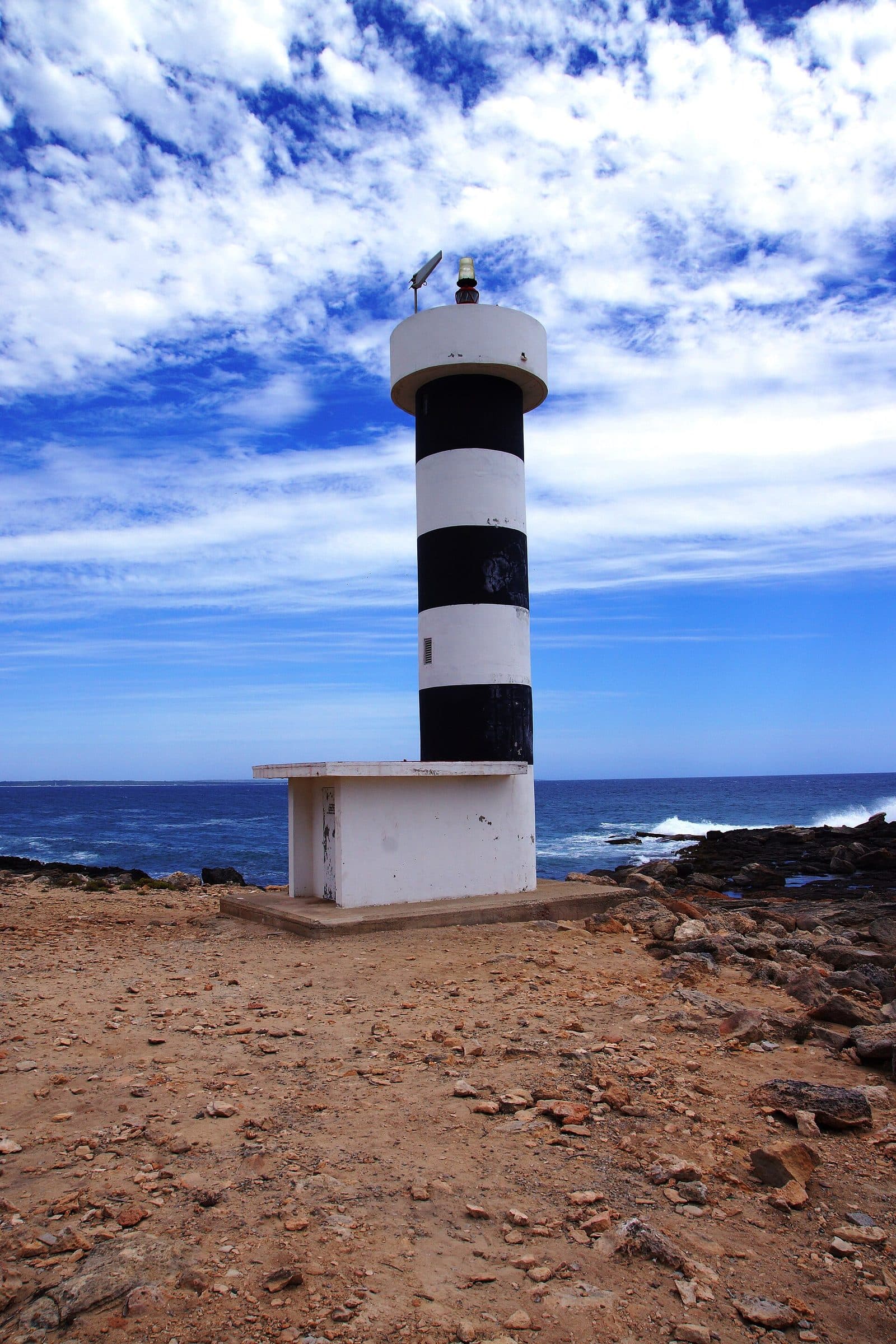
Far de s'Estalella does not stand at the end of a wide access road but beside a coastal path outside S'Estanyol. The approach is therefore part of the experience: beyond the harbor, the asphalt ends, sandy paths follow the low, rocky coastline, and the small lighthouse gradually appears above the low vegetation.
Its appeal comes less from monumental dimensions than from its location. The sea opens out in front of the building, while wind-shaped pines and shrubs huddle inland, and Cabrera may be visible on the horizon. In the opposite direction, the view extends across S'Estanyol with its houses, yacht club, and harbor to the coastline toward Colònia de Sant Jordi.
The trip is particularly suitable for anyone who likes to combine a lighthouse with a short coastal walk. Photographers and families with sure-footed children will also find it a manageable destination. The path and the open landscape take center stage. Those wishing to walk farther can use Far de s'Estalella as the first prominent stop on the coastal path toward Torre de s'Estalella, Vallgornera, and Cala Pi. The lighthouse nevertheless remains a worthwhile destination in its own right—small and active.
History and Significance
Several chapters of coastal history overlap on Punta de s'Estalella. The lighthouse itself belongs to the most recent one: Far de s'Estalella, also known as Faro de Sa Punta Plana, remains active. It is therefore neither an early modern signal tower nor a relic of defenses against pirates, but a navigational aid on a stretch of coast long shaped by fishing and seafaring.
Lighthouse and Defensive Tower
It is particularly important to distinguish between two structures: Far de s'Estalella is the small, active lighthouse near S'Estanyol and helps sailors navigate at sea.
What to See
The first impression is one of restraint. Far de s'Estalella does not tower over the landscape like a large Atlantic lighthouse but stands as a small, round structure on the low rocky coast. Its clean shape stands out against the sea and sky. Precisely because the surroundings are low and largely undeveloped, the building remains clearly visible from some distance away.
Far de s'Estalella
The lighthouse is a comparatively recent, functional navigational aid. Its round shape and compact silhouette are easy to recognize on site. However, the most rewarding views are not found only right beside the building. On the approach, its silhouette can be framed together with the rocky coast; closer to the lighthouse, the relationship between the small structure and the vast, open expanse of sea moves into the foreground. For photographs, it is therefore worth pausing before reaching the destination, looking back along the way, and using viewpoints to the side of the path.
Punta de s'Estalella
The headland is an essential part of the attraction. Some sections of the ground are rocky, the paths are sandy or uneven, and low shrubs characterize the open coastal vegetation. Farther inland stand pines whose twisted and leaning shapes reflect the regular sea winds. This is not the scenery of a landscaped promenade but of a natural-looking coastal path.
The wind can profoundly change how the place feels. On calm days, the expanse of the sea dominates; when the water is rough, the surf and spray become the main spectacle. The offshore edge of the coast is not easy to walk everywhere. Anyone seeking a better view should remain on the recognizable paths instead of taking shortcuts across the sharp-edged and irregular rock surfaces directly beside the water.
The View of Cabrera
From the area around the lighthouse, the view opens across the sea toward the island of Cabrera. It can appear surprisingly prominent on the deep-blue horizon. The panorama is especially appealing because hardly any tall buildings or technical installations obstruct the view. The lighthouse, low vegetation, and outline of the island form the few clear reference points.
Visibility naturally depends on the weather and haze. Even when Cabrera does not stand out clearly, the open horizon remains a principal reason to make the walk. The location vividly demonstrates why a navigational aid visible from afar is useful on this exposed coast.
The View of S'Estanyol
In the other direction lies S'Estanyol with its first row of houses, yacht club, and harbor. From the lighthouse, the village appears compact and close, even though the final steps along the coastal path lead noticeably away from the settlement. Farther to the left, the coastline continues toward the beaches near Colònia de Sant Jordi.
This view back also helps with orientation. While almost nothing but horizon and rock can be seen on the seaward side, S'Estanyol marks the starting point of the walk. The perspective changes particularly on the return journey: the lighthouse disappears behind the low landscape as the harbor, houses, and boats grow larger again.
The Coast Toward Cala Pi
West of the lighthouse, Llucmajor's rocky coast stretches toward Cala Pi. From here, the landscape through which the longer coastal path runs is already visible. Anyone who only wants to visit the lighthouse can turn around at the Far. This glimpse ahead inspires curiosity at the lighthouse, although continuing farther is not necessary for a rewarding visit.
Visiting Far de s'Estalella
A visit usually begins on the seaward edge of S'Estanyol. From the area around the yacht club and the bay of Es Racó de S'Arena, the route initially follows the point where the asphalt becomes a broad sandy track. Beyond the bay, several paths climb gently. The sensible option is the path close to the coast, which meets a wider route and signs marked “Faro.”
The Walk to the Lighthouse
Walking time depends on the chosen starting point in S'Estanyol and how often you stop for views along the way. The route is considered very easy, but it is not a continuously smooth walkway. Sand, exposed rock, and uneven ground require attention. During heavy seas, the area around Es Racó de S'Arena may change or be partly flooded; in winter, seaweed also frequently washes ashore there. In such conditions, do not rigidly follow the immediate shoreline but use the recognizable route over the higher paths.
Time at Far de s'Estalella
The location benefits from its changing perspectives: first the view toward the lighthouse, then out toward Cabrera, back toward S'Estanyol, and finally along the coast toward Cala Pi. Anyone taking photographs or simply wishing to spend time beside the sea will therefore need considerably longer than it takes merely to reach the building.
For the visit, allow for the short walk in each direction and a break of your preferred length at the lighthouse. A fixed total duration would be of little help because many visitors spontaneously extend the excursion to Torre de s'Estalella. The complete coastal circuit from S'Estalella via Vallgornera and back is listed as 8.8 kilometers and 2 hours; however, it is a separate hike and not required for visiting the lighthouse.
Light, Wind, and Crowds
The secluded location often creates a quieter atmosphere than at sights that can be reached directly by car. Complete solitude is not guaranteed, however, because the lighthouse lies on a popular hiking route. Sunset is considered particularly atmospheric, when the lighthouse's silhouette stands out against the colorful sky. Anyone remaining until evening should account for the uneven return route and allow enough daylight for the sections over sand and rock.
Getting There and Parking
The road journey ends in S'Estanyol; Far de s'Estalella is then reached on foot along the coastal path. Navigation should therefore initially be set to the village rather than to a supposed access road leading directly to the lighthouse. In S'Estanyol, continue to the first line of the seafront and then turn right toward the yacht club and Es Racó de S'Arena.
From Palma Airport
The road distance from Palma Airport to S'Estanyol is 37 kilometers. The drive takes around 32 minutes and follows the MA-6015 and Ma-6014. These figures expressly apply only as far as S'Estanyol. The final section is then completed on foot: past the yacht club, to the end of the asphalt, and onward along the sandy and at times rocky coastal path to the lighthouse.
Anyone setting off immediately after arriving at the airport should bear in mind that the walk offers hardly any shade and that the ground is unsuitable for wheeled suitcases. Luggage should therefore remain in the vehicle or at the accommodation, not be taken on the path to the Far. The short nature of the hike does not change the fact that this is a natural trail rather than a paved access road.
From Central Palma
From central Palma, the road distance to S'Estanyol is 43 kilometers. The drive takes around 43 minutes and follows the Ma-19, then the MA-6015 and Ma-6014. Here too, the stated time ends in the village. Additional time must be allowed for the walk from the coast of S'Estanyol to Far de s'Estalella.
The route leads from the urban area into the distinctly quieter coastal landscape near Llucmajor. Shortly before the destination, the key is not to search for the closest possible point to the lighthouse but to navigate toward the harbor and the bay of Es Racó de S'Arena. The access route described in the local hiking information begins there.
Parking in S'Estanyol
Anyone arriving from the direction of Llucmajor should drive to the sea and turn right there. Parking is available in the area where the paved road, or Vía de la Mediterrània, becomes an unpaved track. The vehicle remains in S'Estanyol; driving along the sandy track to the lighthouse is not part of the visitor route described here.
On busy days, it is advisable to use a suitable legal parking space within the village rather than hoping for the last free spot at the transition to the coastal path. The additional walk leads through the harbor area and fits naturally into the excursion. Access roads, turning areas, and entrances to private property should, of course, be kept clear.
By Bus
Possible stops for S'Estanyol include S'Estanyol 1 and S'Estanyol 2; Son Bieló 1 and Son Bieló 2 are also located within the wider village area. From the relevant stop, continue on foot toward the sea, harbor, and Es Racó de S'Arena. As timetables and routes may change, check the specific connection for the day of your visit.
The bus therefore replaces only the road journey to S'Estanyol. The scenic final section remains a walk. This is part of the character of Far de s'Estalella: the building is not viewed through a car window but gradually reveals itself as you leave the village behind.
Bus lines to Far de s'Estalella at a glance
| Line | Route | Departures/day | First | Last |
|---|---|---|---|---|
| 508 | Sa Ràpita - Palma | 100 | 06:29 | 22:57 |
From the official GTFS feeds (TIB/SFM), no real-time data. The figures cover all stops in the town; weekend and holiday services differ — check with the operator before travelling.
Getting there by bus
S'Estanyol 2 (31051) · 1.0 km as the crow flies
- 508Sa Ràpita - Palma · Daily
S'Estanyol 1 (31052) · 1.1 km as the crow flies
- 508Sa Ràpita - Palma · Daily
Son Bieló 2 (31053) · 1.6 km as the crow flies
- 508Sa Ràpita - Palma · Daily
Son Bieló 1 (31054) · 1.6 km as the crow flies
- 508Sa Ràpita - Palma · Daily
Timetable data: official GTFS feeds (TIB/EMT), no real-time — check with the operator before travelling.
Nearby Places
S'Estanyol de Migjorn is the natural starting point for visiting the lighthouse. The small coastal village has a harbor and a yacht club; its row of houses remains visible for a long time on the walk to the Far. After returning, the village is the obvious place to take a break before continuing the journey.
S'Estanyol de Migjorn
Today's walk connects both areas visually and through the landscape: from the harbor, it leads into a more open coastal zone where fishermen's buildings and boathouses recall earlier uses. S'Estanyol is more than merely a parking place for the lighthouse. The transition between harbor basin, bay, sandy path, and open rocky coast explains why the outing is more varied than the short walking time might suggest. On the return route, the village once again appears as a distinct counterpoint to the undeveloped headland.
Es Racó de S'Arena
Es Racó de S'Arena lies directly at the beginning of the coastal path. The small bay can appear calm in summer, but its character changes considerably with the weather and season. In winter, rough seas meet the beach directly, and larger quantities of seaweed frequently accumulate there. With the corresponding sea conditions, the passage immediately beside the water can be uncomfortable or wet.
The bay is therefore less a reliable promise of swimming than a vivid introduction to the coastal landscape. It shows how exposed this section is to the sea. Beyond it, sandy paths climb to the marked route toward “Faro.”
Torre de s'Estalella
The tower is a suitable extension for visitors who want to turn the short lighthouse walk into a longer coastal hike. The path crosses rocky terrain through low vegetation and passes wind-shaped pines. This section is not necessary for a visit limited to the Far.
Vallgornera and Cala Pi
The signposted coastal path can be continued beyond the defensive tower toward Vallgornera and Cala Pi. The complete circuit is listed as 8.8 kilometers and 2 hours and is considered very easy. Despite this rating, the ground is rocky in sections, and the exposed location requires more preparation in sun and wind than a city walk.
This longer route is especially worthwhile if the lighthouse is to be experienced as part of half a day of hiking. Anyone planning only a short excursion can turn around at the Far and enjoy the view of the Cala Pi coast as a panorama. Both are rewarding ways to visit; the key is not to base your time and water supply solely on the lighthouse's small size.
The place it belongs to
S'Estanyol in the place guidePractical Information for Your Visit
Far de s'Estalella may look easy to reach in photographs, but a genuine coastal path lies between S'Estanyol and the building. Sand, loose ground, and rocky sections are all part of the route. Sturdy shoes with good grip are therefore more suitable than smooth sandals. This is particularly true if you intend to continue beyond the lighthouse to the defensive tower.
Sun and Shade
The landscape on the headland is open. Low shrubs provide no reliable shade, and the wind-shaped pines are not positioned in a way that allows shaded breaks along the entire route. Sun protection and water should therefore be carried even on a short excursion. The wind can make it easy to underestimate the strength of the sun.
In the evening, the light provides good conditions for photography, but twilight also imposes limits on the uneven return route. Anyone wishing to experience sunset at the Far should not treat the way back to S'Estanyol like an illuminated promenade. The visible path is straightforward in daylight but requires more attention as the light fades.
With Children
The local coastal route is described as very easy. For children who are accustomed to walking and are sure-footed, the Far can therefore be a motivating destination: the building remains within manageable reach, while harbor, bay, sandy path, and sea views alternate along the way.
Caution is nevertheless necessary directly beside the rocky coast. The path is not an enclosed leisure facility, and the open landscape has neither consistently level surfaces nor protection from sun and wind everywhere. During heavy seas, it is particularly important to move onto a higher path early at Es Racó de S'Arena.
Navigation on the Coastal Path
After the asphalt ends, the route first leads to the bay. Beyond it, sandy tracks climb upward; the option close to the coast meets a wider path with signs for “Faro.” At the first fork, continue straight ahead, then turn left and pass a small house on the way to the lighthouse. Keeping this sequence in mind means there is no need to follow every random track through the vegetation.
For the return journey, S'Estanyol serves as a clearly visible landmark. If continuing toward Torre de s'Estalella, however, bear in mind that the route becomes longer and rockier. An offline map can be helpful on an extended hike but does not replace paying attention to signs and terrain.