
Faro de Cala Figueira – Lighthouse on the Edge of Palma Bay
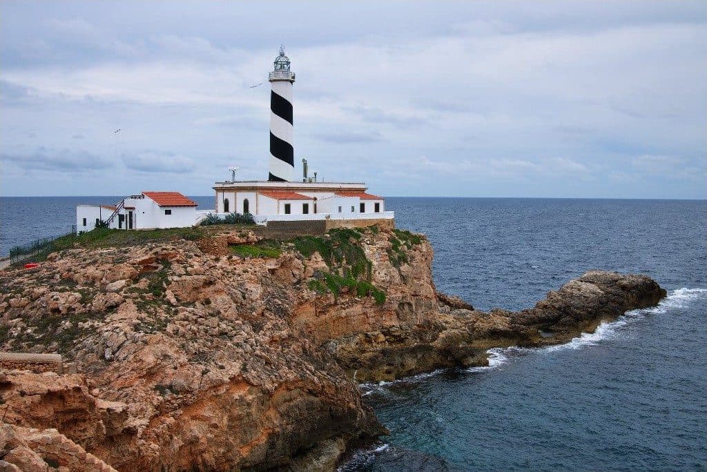

Faro de Cala Figueira stands where the western side of the Bay of Palma opens onto the Mediterranean. A black spiral winds around the white tower, with almost nothing but the horizon beyond. The lighthouse near Sol de Mallorca is not a conventional attraction with an exhibition and visitor centre, but a working navigational aid in a rugged coastal landscape.
It is precisely this understated character that makes a visit so appealing. There is more to see than the tower, lantern and former residential and service buildings: traces also remain of a time when fuel and provisions were brought up from the sea. The remains of the small landing stage and old supply path tell this story more vividly than any display case.
The headland is especially suitable for those who want to combine coastal walks, maritime technology and photography. However, the route requires more preparation than a quick stop at a roadside lighthouse: the ground is uneven in places, there is no shade or visitor infrastructure, and care is needed near the coastal edge.
This Faro de Cala Figueira should not be confused with the fishing village of Cala Figuera near Santanyí or the bay of the same name at Cap de Formentor. This guide is exclusively about the lighthouse at Cap de Cala Figuera near Sol de Mallorca in the southwest of the island.
History and significance
At dawn on 1 April 1953, the “Ciudad de Palma” ran aground at Punta de Mulá. No one lost their life in the accident, but the incident shows why a reliable navigational aid was so important at this corner of Mallorca. The headland marks the western edge of the Bay of Palma; ships encounter an exposed coast here, where severe southwesterly weather even affected lighthouse operations.
Emili Pou’s design
The station was designed by Emili Pou. It entered service on 31 July 1860, initially as a sixth-order lighthouse with a fixed white light. In fact, the beacon was fitted with a fifth-order optic. Lamps with a constant fuel level provided the light—a technology that still required continual maintenance, fresh supplies and the presence of lighthouse keepers.
Supplies initially arrived by boat. A small landing place and a path were therefore built into the rocks so that fuel and food could be carried from the sea up to the buildings. Remains of both can still be seen today. They form an often overlooked but particularly revealing chapter in the site’s history: the Faro was not merely a tower, but a remote place of work and residence with its own supply route.
From a fixed light to a flashing signal
The light characteristic changed in 1919. Rotating screens in front of the optic now produced two eclipses in a cycle of ten seconds. The acetylene required was generated in a gas generator housed in an extension. When this system failed in 1950, the staff returned to paraffin-fuelled Maris and Aladdin lamps, which were used alternately.
The major technical conversion followed in 1962. The old lantern was replaced with a model suitable for maritime and aviation use, the tower was raised and the light was electrified. A new fourth-order optic was installed at the same time. Since this modernisation, the characteristic still used today has consisted of a group of four white flashes within twenty seconds. At the time, electric lamps rated at 1,500 watts generated the light.
Radio beacon and El Toro
At times, the station’s responsibilities extended beyond the immediate headland. After an automatic beacon was installed on the small island of El Toro in 1926, the lighthouse keepers from Cala Figuera also maintained this navigational aid. They were collected from the landing place by the Faro and taken to the island.
A radio beacon entered service at the lighthouse in September 1970; the living quarters were extended in the same year. The radio beacon was later replaced by a differential GPS station. Faro de Cala Figueira is therefore not an abandoned relic. It remains an active navigational aid, even though automation and satellite technology have replaced the keepers’ former way of life and work.
What to see
Even from a considerable distance, it is clear why the tower has such a memorable daymark. A black spiral winds around the white, conical shaft, making it unmistakable even without its light. This paintwork dates from the period of comprehensive modernisation and clearly distinguishes the Faro from many of Mallorca’s plainer white coastal lighthouses.
The tower with the black spiral
The tower is 24 metres high. Its lantern reaches a focal height of 45 metres above the sea. Both dimensions are easy to appreciate on site: the structure itself does not seem enormous, but its position on the headland and the unobstructed horizon give it a commanding presence. The lantern installed in 1962 sits above the conical shaft, replacing the earlier model.
In daylight, the spiral is the defining detail. Depending on the viewpoint, it appears as a broad black band, a diagonal division or an almost graphic pattern against the sky and sea. Photographers should therefore capture the tower from more than just the front. Even a slight change in perspective alters the way the band appears to wind around the shaft.
The active beacon
After dark, the light characteristic identifies the lighthouse. The Faro emits four white flashes in a cycle of twenty seconds. The light is not visible in every direction but operates within a defined sector over the sea.
The technical equipment also includes a fog signal. In a cycle of ten seconds, it produces two signals, each lasting two seconds. There is also a differential GPS station, which replaced the former radio beacon. Modern navigational infrastructure therefore lies behind the romantic silhouette—the tower is not merely scenery but part of the active system protecting maritime traffic.
Residential and service buildings
The station’s associated buildings stand at the foot of the tower. Their history explains why the complex includes more than the light-bearing structure itself: the keepers lived and worked here, while fuel and technical equipment were stored on site. The living quarters were extended in 1970, when operations had already been electrified but staff still carried out duties at the station.
Strong southwesterly winds demonstrate how exposed the building complex is. Because the cliffs are relatively low, waves could reach the lighthouse facilities during heavy seas. Its waterside position is therefore not merely scenic; it also shaped maintenance, structural upkeep and everyday life at the station.
Landing stage and supply path
The remains of the small landing stage below the lighthouse are easy to overlook. From there, a specially constructed supply path climbed the rocks. Provisions and fuel were carried along it to the station when deliveries still arrived by boat. Looking at this section of coast reveals a practical response to the site’s isolation.
These traces are among the most interesting details at Faro de Cala Figueira. They connect the structure directly with the sea it was intended to safeguard. At the same time, they are a reminder that operating a lighthouse once involved many unseen tasks: landing, unloading, carrying supplies uphill, tending the lamps and keeping the optic operational.
Headland and sea views
From the rocky promontory, views open across the Mediterranean and the outer part of the Bay of Palma. Passing boats can be observed alongside seabirds above the coast. The rugged rocks add depth to the panorama and make it clear why this particular headland was chosen for a beacon.
The finest impression is not necessarily found immediately beside the structure. Viewpoints from farther away reveal the complete silhouette of the tower, outbuildings and coastline. Restraint is essential near the cliff edges: the terrain is rough, and the safe path should never be left for the sake of a photograph.
Visiting Faro de Cala Figueira
Faro de Cala Figueira reveals itself gradually. The route first passes through the coastal landscape, then the black-and-white spiral appears above the terrain, and only nearer the cape do the buildings, rocks and open sea become visible as a single station. Anyone expecting only a quick photo stop will therefore underestimate both the approach and the appeal of the historic remains.
Arriving via the coastal path
The final section is covered on foot. The path can be uneven and stony, and junctions are not always clear. Marked routes should therefore be followed, also to avoid straying onto private property. The visit itself begins before reaching the Faro: approaching across the rocky headland is an essential part of the experience.
It is not practical to specify a fixed visit length. Those who only want to see the exterior silhouette and sea view will stay for less time. Considerably longer should be allowed for the supply path, the remains of the landing stage, different photography viewpoints and a break overlooking passing boats. The walk from where the vehicle is left must also be included.
Morning and evening light
Morning and evening light provide the most interesting conditions for photography. During the golden hour, the black spiral stands out particularly clearly against the warmly lit tower, while the rocks appear more sculpted. Sunrise and sunset are therefore both popular with photographers.
After sunset, the active characteristic can be observed: four white flashes within twenty seconds. However, the return route and uneven ground must then be considered. A route checked in advance becomes even more important than during daylight.
Not a conventional museum visit
Visitors should not expect a visitor centre, exhibition or tourist infrastructure on site. The Faro is an automated and unmanned coastal light. The focus is on its exterior appearance, landscape and operational history—not on touring interior rooms.
Current access conditions should be checked before setting out, as no reliable visiting hours are recorded. There is also no current admission price available. The key distinction is between lighthouse operations and access to the surrounding coast: an active navigational aid is not automatically a museum open to the public.
Getting there and parking
The road journey ends in Sol de Mallorca; the Faro itself lies farther out on the headland and is reached on foot for the final section. Navigation and time planning should take this separation into account. Anyone who calculates only the driving time to the settlement has not yet completed the actual approach to the lighthouse.
From Palma
From central Palma, the road distance to Sol de Mallorca is 18 kilometres. The journey takes around 25 minutes and follows the Ma-1 southwest. This information expressly applies only as far as Sol de Mallorca, not directly to the Faro. The local access route and walk towards Cap de Cala Figuera follow from there.
It is particularly helpful to remember the starting point of the footpath for the return journey. Paths in the coastal area can appear confusing, and not every visible track is suitable or public. Markers and established paths should take priority over apparent shortcuts.
From Palma Airport
The road distance from Palma Airport to Sol de Mallorca is 28 kilometres. The journey takes around 26 minutes, initially following the Ma-20 and then the Ma-1. Once again, the distance and driving time refer to the settlement. Additional time is required to find parking, prepare and complete the subsequent walk to the lighthouse.
The route is therefore straightforward on the main road network; the final coastal stage is more demanding. Sturdy shoes should not remain in the luggage until the Faro but should be put on at the vehicle.
Parking and the final section
Do not expect to park directly beside the tower. Vehicles are left near the landward access route, after which the journey continues on foot. As parking conditions and possible access restrictions may change, checking the current route before departure is recommended. Vehicles must not block access roads or private property.
No bus stop is recorded in the immediate vicinity of the Faro. A journey made entirely by bus therefore does not reach the beginning of the coastal section and requires additional planning. For the immediate visit, a car combined with the walk is the more practical option; otherwise, a longer approach on foot must be anticipated.
Nearby places
Sol de Mallorca feels like a peaceful counterpoint to the better-known holiday resorts in the southwest. The settlement lies on the western side of the Bay of Palma and belongs to the municipality of Calvià. Paths lead from the built-up area to a coast characterised by coves, rocks and pines. At the outermost cape, the Faro forms the maritime conclusion.
Sol de Mallorca and Portals Vells
Combining the lighthouse visit with Portals Vells is an obvious choice. Several small beach coves lie there, while Ses Coves de Mare de Déu recall the historic quarrying of sandstone. Stone from the caves was used in the Middle Ages for important buildings in Palma, among other purposes. The caves later became associated with the story of Italian sailors who sought shelter during a storm and promised an altar to the Virgin Mary.
A clear sequence works well for planning the day: first visit the Faro and the exposed coastal path while temperatures are still manageable, then continue to one of the more sheltered coves. This keeps the walk and beach visit separate, while water and sun protection can be planned specifically for the unsupplied section at the cape.
Cala Portals Vells and Cala Vinyes
The beaches of Cala Portals Vells lie in a more varied coastal landscape than the lighthouse. They make a scenic addition to the trip without turning the Faro itself into a swimming destination. The area around the cape remains primarily a place for views, coastal history and walking.
Farther north, Cala Vinyes offers a sheltered sandy cove. Visitors travelling with children can plan the more demanding walk to the lighthouse separately from a subsequent beach visit. The rocky surroundings of the Faro have neither the infrastructure nor the character of a family beach.
Son Ferrer, El Toro and Santa Ponsa
Son Ferrer lies inland near the cape and serves as a useful point of reference on the road network. El Toro and Santa Ponsa lie farther west. El Toro is also historically connected with the lighthouse through its position opposite the small island of the same name: the keepers from Cala Figuera once maintained the automatic beacon installed there in 1926.
Santa Ponsa is suitable for a meal or a stroll afterwards. Even so, a longer tour of the southwest should not be scheduled too tightly. The appeal of Faro de Cala Figueira lies precisely in not squeezing the walk and views between several rushed photo stops.
The place it belongs to
Sol de Mallorca in the place guidePractical information for your visit
Between the parked vehicle and the lighthouse, there is little to compensate for poor preparation. The coastal path is not a paved promenade, there are no tourist services at the cape, and the open sky offers almost no protection from the sun. A small backpack is more useful here than expecting to buy something along the way.
Footwear, water and sun protection
Sturdy shoes with grippy soles are advisable because of the uneven, rocky ground. Sandals for a later beach visit can be carried but should not be the only footwear option on the way to the Faro. Water, head covering and sun protection also belong in your bag, as there are no visitor facilities directly beside the lighthouse.
Strong winds significantly change the experience of the visit. The cape is exposed, and historically, southwesterly storms could even drive waves as far as the facilities. In rough weather, it is therefore especially important to keep well away from cliff edges and surf zones. Marked paths should not be left, regardless of the photographic opportunities.
Visiting with children
Children are most likely to enjoy the Faro if they can already walk confidently on stony ground and reliably follow instructions near the coastal edge. The black-and-white spiral, the light characteristic and the story of the old boat landing provide good points of interest. However, this is not an effortless outing with a pushchair, playground and toilet facilities.
Adults should supervise children closely near the cliff edge and take the return journey into account. As a family activity, the Faro is better combined with a sheltered cove nearby than treating the rocky headland itself as a swimming spot.
What not to expect on site
Faro de Cala Figueira is not a museum with a regulated visitor route. It is an active, automated navigational aid. The value of the visit lies in the exterior structure, its location at the edge of the Bay of Palma and the surviving traces of the former supply system.
The headland should likewise not be confused with the fishing village of Cala Figuera near Santanyí. Entering only the name of the bay into a navigation device may lead to the other end of Mallorca. The destination must be set as the Faro near Sol de Mallorca or Cap de Cala Figuera in the southwest.
Local insider tips
See the spiral from a distance
The tower looks most striking from farther away: only then do the black spiral, outbuildings and rocky coastline appear together in the frame. Several safe viewpoints visibly change the way the black band winds around the tower.
Look for the old landing stage
Do not photograph only the tower: below the station, remains can be seen of the small landing stage and former supply path. Provisions and fuel once arrived from the sea along this route.
Choose early morning for peace
Morning and evening light define the tower and rocks particularly clearly. Those who also prefer fewer encounters along the path should choose early morning rather than the more popular golden hour before sunset.
Spot the four flashes
After dark, the active light characteristic can be observed: four white flashes within twenty seconds. A torch and a route checked in advance are important for the unlit, uneven return journey.
Faro first, cove afterwards
It is best to walk the coastal path before the strongest heat of the day and plan the beach visit afterwards. Portals Vells or Cala Vinyes are better suited to the second half of the day than the rocky surroundings directly beside the lighthouse.