
Mirador de ses Serveres near Estellencs
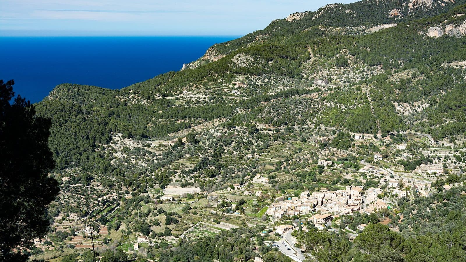

Between woodland, old working land, and the steep coast of Estellencs, the view opens toward the sea at Mirador de ses Serveres. This is precisely what makes it so appealing: the view is not merely a brief interruption to a drive but the highlight of a route through the western part of the Serra de Tramuntana.
The Mirador belongs to the area of Boal de ses Serveres and the public recreational landscape on the former Son Fortuny estate. Along the way, traces appear of a time when woodland, farmland, and livestock farming shaped the terrain. A former charcoal-burning site and a large threshing floor reveal that these slopes were a place of work long before they became a hiking area.
From the viewpoint, the gaze extends across the coast of Estellencs. Rather than a harbor panorama, restaurant terrace, or urban setting, visitors encounter a rugged combination of wooded slopes, coastal relief, and open sea. Mirador de ses Serveres is therefore particularly suitable for hikers who enjoy combining a view with landscape and cultural history.
Its location must be clearly identified: Mirador de ses Serveres is near Estellencs. It should not be confused with the similarly named Mirador de ses Barques near Sóller, which overlooks Port de Sóller and is an entirely different attraction.
History and Significance
Before hikers came here in search of a viewpoint, the landscape was actively used. The terrain around Boal de ses Serveres belonged to the large Son Fortuny estate, whose woodlands and open areas supported forestry, agriculture, and livestock farming. Today’s route therefore does not pass through supposedly untouched wilderness, but through a cultural landscape in the Serra de Tramuntana that was worked over a long period.
Son Fortuny
Son Fortuny also combined different forms of economic activity: wood and other products came from the forest, animals grazed on suitable land, and workable areas were farmed.
This context is crucial to understanding the Mirador. It did not emerge as an isolated monument whose history could be read from a façade. Its significance comes from the terrain through which the access route passes. Anyone walking toward the coastal view and passing the old working areas experiences a small part of the economic landscape that continues to shape the appearance of the Tramuntana today.
The Public Recreation Area
The land was acquired by the Consell de Mallorca and opened as a public leisure and recreation area. Part of the former estate thus became a place for hiking, experiencing the landscape, and encountering traces of historic land use. Mirador de ses Serveres forms a natural destination within this area: beyond the forest and high-level paths, the view opens onto the coast of Estellencs.
This transformation also explains the understated character of the site. There is neither a prestigious building nor a museum-style presentation at its center. The terrain itself tells the story. Forest, path, charcoal-burning site, threshing floor, and view belong together, showing how a worked section of Son Fortuny became a publicly accessible landscape.
Old Routes and the New Road
The approach also tells the story of the region’s transformation. At the edge of Estellencs, the old road to Andratx runs parallel to the newer Ma-10. The historic route passes Camí des Port and the cemetery, climbs in bends toward Coll des Pi, and later passes beneath the new road. At kilometer point 97 on the Ma-10, a signposted turn leads toward Coma d’en Vidal and Boal de ses Serveres.
Old and new transport routes lie close together here, but they serve different purposes. The Ma-10 carries modern traffic along the Tramuntana, while the older connection makes access to the landscape easier to understand. At the end of this development, the Mirador stands not as a monument but as a viewpoint within an evolved network of paths.
What to See
The most powerful moment comes only after the walk through the area. Among the trees and historic working spaces, little suggests how widely the horizon will open at Mirador de ses Serveres. Then the coast of Estellencs moves into the foreground: mountain slopes descend toward the sea, the shoreline becomes visible from above, and beyond the water the densely structured Tramuntana landscape ends abruptly in open space.
The Coastal View of Estellencs
The official route description explicitly mentions the view over the coast of Estellencs. This is precisely what distinguishes the Mirador from better-known roadside viewpoints focused on a harbor, a single rock, or a village. Here, a broader section of the landscape takes center stage. The view connects the sea with the slopes that characterize the municipality of Estellencs.
The effect changes with visibility. In clear air, the course of the coast and the layered elevations stand out more distinctly; in haze, the water and horizon merge more closely. Because the viewpoint forms part of a hiking landscape, the panorama does not feel detached from the route. The climb, the forest, and the older working areas remain present as a spatial experience.
The Forest of Son Fortuny
The path to the viewpoint leads through woodland on the former Son Fortuny estate. This section is more than a green backdrop. It recalls the area’s former forestry use and forms the transition between the road and the open coastal view. The interplay between enclosed woodland and unobstructed views defines the character of the visit.
At the same time, the forest makes it clear why the Mirador does not feel like an urban viewing terrace. The view is reached gradually. At first, the course of the path, vegetation, and terrain draw attention to the immediate surroundings; only at the viewpoint does the perspective widen. Anyone focused solely on the final photograph misses an essential part of the place.
The Former Charcoal-Burning Site
Near the path to the small mountain hut is an area formerly used by charcoal burners. Such workplaces were part of the traditional use of the Tramuntana forests. For visitors, this site is a quiet reminder that the woodland not only supplied timber but was also a setting for specialized labor.
The charcoal-burning site should not be expected to resemble an elaborate exhibition. Its value lies in its connection to the terrain: its location in the forest and proximity to the paths explain more than a detached museum object could. It shows why the history of Ses Serveres would be incomplete without the use of Son Fortuny.
The Large Threshing Floor
Farther along the route is a large threshing floor. It points to the agricultural side of the estate’s former operations and contrasts with the charcoal-burning site in the forest. Both places represent different stages of work and forms of land use that existed side by side in the same mountain landscape.
The threshing floor is also a good example of how inconspicuous historic remains can be in a hiking landscape. Those who see the path merely as a connection to the Mirador can easily pass it without recognizing its former purpose. With this knowledge, the route becomes a brief cultural and historical reading of the terrain: first the old routes, then forestry and agriculture, and finally the view across the coast.
The Small Mountain Hut
A path leads to a small mountain hut within the public area. It serves as another landmark in the landscape but is not the Mirador itself. The viewpoint, hut, charcoal-burning site, and threshing floor are all part of the same visit, but they should not be confused with one another.
This distinction is useful for orientation: reaching the hut does not necessarily mean that the coastal view has already been found. After the historic working areas, the official description continues to the point where the view opens onto the coast of Estellencs.
Visiting Mirador de ses Serveres
Ideally, a visit should not begin with the expectation of a brief roadside stop. Mirador de ses Serveres belongs to a network of routes leading from the outskirts of Estellencs along older road sections and up into the area of Boal de ses Serveres. The approach itself is part of the experience: the route passes Camí des Port, the cemetery, Coll des Pi, and finally the entrance to the public area.
The Viewpoint as a Hiking Destination
A long stay is not required at the Mirador itself. However, the total time needed depends greatly on where the hike begins and which route is chosen. One published tour from Estellencs to the Mirador covers 6.2 miles, is rated moderate, and includes 1,410 feet of elevation gain. Around three and a half to four hours are allowed for this complete hike.
These details describe the tour, not the amount of time spent at the viewpoint itself. Those walking only part of the approach will need correspondingly less time; anyone who pauses to examine the charcoal-burning site, threshing floor, and forest or takes breaks should plan more generously. The Mirador is therefore suitable both as the main destination of a hike and as a stop on a longer circuit through the Son Fortuny area.
The Route via Boal de ses Serveres
After the signposted entrance near the Ma-10, the route leads into the public area of Coma d’en Vidal and Boal de ses Serveres. The historic working areas appear near the path to the mountain hut before the viewpoint is reached. This sequence gives the visit a clear progression: from the road network into the forest, from traces of past labor to the open coast.
The paths should not be treated like a fully developed promenade. The longer tour’s moderate rating and substantial elevation gain alone indicate a genuine hiking excursion. An up-to-date route map is useful, especially if a circular hike rather than only the direct approach is planned.
Time of Day and Crowds
Regardless of the time of day, it is worth allowing enough time for the route and not setting out shortly before nightfall. Opening hours and admission details have not been reliably recorded; current information about the public area should therefore be checked before visiting.
Getting There and Parking
The stated driving routes lead to Estellencs, not directly to Mirador de ses Serveres. This is important for planning: after arriving in the village, the approach continues via the local road and path network toward Boal de ses Serveres.
From Central Palma
The road distance from central Palma to Estellencs is 36 kilometers. The drive takes around 64 minutes via the Ma-1110, Ma-1120, and Ma-10. The final section in particular enters the winding mountain terrain of the Serra de Tramuntana; despite the manageable distance, the comparatively long driving time should be taken seriously when planning the day.
In Estellencs, the onward route initially follows the old road toward Andratx. At the edge of the village, it runs parallel to the newer Ma-10. After a short distance, Camí des Port branches off; the entrance to the cemetery is also located there. The old road then climbs in bends toward Coll des Pi, passes beneath the new road, and meets it again at kilometer point 97. A sign there points toward Coma d’en Vidal and Boal de ses Serveres.
From Palma Airport
The road distance from Palma Airport to Estellencs is 41 kilometers. The drive takes around 59 minutes via the Ma-20, Ma-1110, and Ma-1120. This travel time also ends in the village. Additional time must be allowed for orientation, transferring to the local access route, and walking to the viewpoint.
Anyone planning to set out immediately after landing should bear in mind that the Mirador is not a casual photo stop on an airport route. The published longer hike takes three and a half to four hours. Travel, navigation, breaks, and the return route must be added to the driving time alone.
Parking and Final Approach
The described route provides access to the Mirador through the public area and along a path passing the mountain hut, charcoal-burning site, and threshing floor.
By Bus
Several bus stops are located in the Estellencs area. They can serve as starting points for an approach from the village, but they do not replace the walk to the Mirador. Because timetables and connections can change, the service should be checked for the day of the visit, with the return journey factored into the schedule. Particularly on a hike lasting several hours, it is important to leave enough time before the final planned return service.
Bus lines to Mirador de ses Serveres at a glance
| Line | Route | Departures/day | First | Last |
|---|---|---|---|---|
| 202 | Estellencs - Palma | 90 | 06:35 | 21:22 |
| 131 | Santa Ponça - Banyalbufar | 8 | 11:10 | 16:25 |
From the official GTFS feeds (TIB/SFM), no real-time data. The figures cover all stops in the town; weekend and holiday services differ — check with the operator before travelling.
Getting there by bus
Estellencs 2 (21007) · 1.2 km as the crow flies
- 131Santa Ponça - Banyalbufar · Daily
- 202Estellencs - Palma · Daily
Estellencs 1 (21002) · 1.2 km as the crow flies
- 131Santa Ponça - Banyalbufar · Daily
- 202Estellencs - Palma · Daily
Can Rave 2 (21006) · 1.9 km as the crow flies
- 131Santa Ponça - Banyalbufar · Daily
- 202Estellencs - Palma · Daily
Can Rave 1 (21009) · 1.9 km as the crow flies
- 131Santa Ponça - Banyalbufar · Daily
- 202Estellencs - Palma · Daily
Timetable data: official GTFS feeds (TIB/EMT), no real-time — check with the operator before travelling.
Nearby Places
Estellencs is not only the starting point but also the key to understanding the Mirador’s landscape. The village lies on the western slopes of the Serra de Tramuntana, between mountainous terrain and the sea. Its steep streets, traditional stone houses, and compact layout suit an excursion where walking matters more than ticking off numerous individual sights.
Estellencs
A walk through the village is worthwhile before or after the hike. Its elevated position makes the transition between settlement, cultivated slopes, and coast easy to recognize. The old connection toward Andratx, which plays a role in reaching Ses Serveres, also begins here. A village visit can therefore be directly linked to the history of the route network.
Visitors arriving from Palma should not treat Estellencs merely as a place to search for parking. A short walk through its streets helps with spatial orientation: on one side, the terrain descends toward the coast; on the other, it climbs toward Son Fortuny and Boal de ses Serveres. The Mirador later presents the same landscape from a greater height.
Cala Estellencs and Port d’Estellencs
The coast can be experienced from more than a distance. Cala Estellencs and Port d’Estellencs lie below the village and offer a worthwhile addition for anyone who wants direct contact with the sea after the mountain landscape. However, the descent to the coast should be planned as a separate route section and extends an already hiking-intensive day.
A longer circular route can link the coastal area, paths around Estellencs, and Boal de ses Serveres. Such outings, however, involve considerably more than a short visit to the Mirador. For relaxed planning, it is often better to make either the viewpoint or the coastal descent the main focus.
GR 221 and Son Fortuny
The long-distance GR 221 trail crosses the municipality of Estellencs on the section between Calvià and Estellencs. The Mirador therefore lies in a region where old paths are now part of a broader hiking network. Anyone already walking the GR 221 can place Ses Serveres within a wider exploration of dry-stone paths and historic connections.
Longer circuits along paths through Son Fortuny are also possible. Consideration is especially important here: routes run close to properties and through a sensitive landscape. Staying on designated paths and avoiding unnecessary noise protects both nature and the interests of residents and land users.
The place it belongs to
Estellencs in the place guidePractical Information for Your Visit
Mirador de ses Serveres rewards preparation more than spontaneous haste. Those setting out with sturdy footwear, sufficient water, an up-to-date map, and a realistic schedule can focus on the landscape along the way. Anyone expecting an easily accessible roadside terrace will underestimate the character of the destination.
Footwear and Navigation
Shoes with good grip are appropriate for the longer route. The tour is described as moderate and includes 1,410 feet of elevation gain, so it is not a level village stroll. Even shorter approaches cross mountain terrain where the surface and gradient matter more than the distance alone.
A saved or printed route map is useful because several names and destinations lie close together: Coma d’en Vidal, Boal de ses Serveres, the mountain hut, and the actual Mirador. The route to the hut and the viewpoint are not the same. Anyone following only a single place name may mistakenly believe the destination has already been reached.
Sun, Weather, and Water
Wooded sections should not obscure the fact that the viewpoint and parts of the route are exposed. Sun protection and drinking water therefore belong in your backpack. Visibility can also change in the Tramuntana; poor long-distance views reduce some of the coastal panorama’s impact, while wet ground can make the route more demanding.
It is worth checking local weather conditions before setting out. An early start is more comfortable in intense heat, while a shorter route should be chosen in uncertain weather. The viewpoint is not a sensible place to notice a change in conditions too late and then face a rushed return.
With Children
For children accustomed to hiking, Ses Serveres can be an engaging destination because forest, former working areas, and coastal views alternate along the route. However, the complete tour from Estellencs, with 6.2 miles, substantial elevation gain, and three and a half to four hours of walking, should be treated as a proper hike. It will not automatically suit every age or fitness level.
Families should choose the route according to experience and weather, allow enough breaks, and remain attentive at exposed viewpoints. A moderate mountain hike with this elevation profile is not suitable for a stroller. A shorter approach may make more sense, but it should be prepared using current route information.
What Not to Expect
The Mirador is primarily a landscape destination. The route, historic traces of land use, and view over the coast of Estellencs are the main attractions. A large exhibition, developed viewing complex, or organized activity program is not the reason to visit.
This very simplicity is what makes Ses Serveres interesting. The place reveals itself through connections: the old road explains the access, Son Fortuny the history of land use, the charcoal-burning site and threshing floor the former work, the forest the transition, and the Mirador, finally, the location between the Tramuntana and the sea.
Local insider tips
Let the View Remain a Surprise
The strongest impression comes from consciously experiencing the route through the forest. Only after the charcoal-burning site, threshing floor, and area around the small mountain hut does the view open onto the coast of Estellencs.
Look for the Charcoal-Burning Site
Many visitors focus entirely on the Mirador. Near the path to the mountain hut, however, is a former charcoal burners’ workplace—an important detail from the earlier woodland use of Son Fortuny.
Find the Large Threshing Floor
Farther along the route is a large threshing floor. Together with the charcoal-burning site, it shows that Ses Serveres offers more than views: the path crosses a former working landscape shaped by forestry and agriculture.
Distinguish the Mirador from the Hut
The small mountain hut is a landmark but not the viewpoint itself. The path continues afterward to the coastal view, so do not turn around at the hut and miss the actual Mirador.
Do Not Confuse It with Ses Barques
When using navigation, pay close attention to the name and to Estellencs. Mirador de ses Serveres belongs to Son Fortuny; the similarly named Mirador de ses Barques is near Sóller and offers a different coastal panorama.