
Mirador des Grau: Views over Mallorca’s West Coast
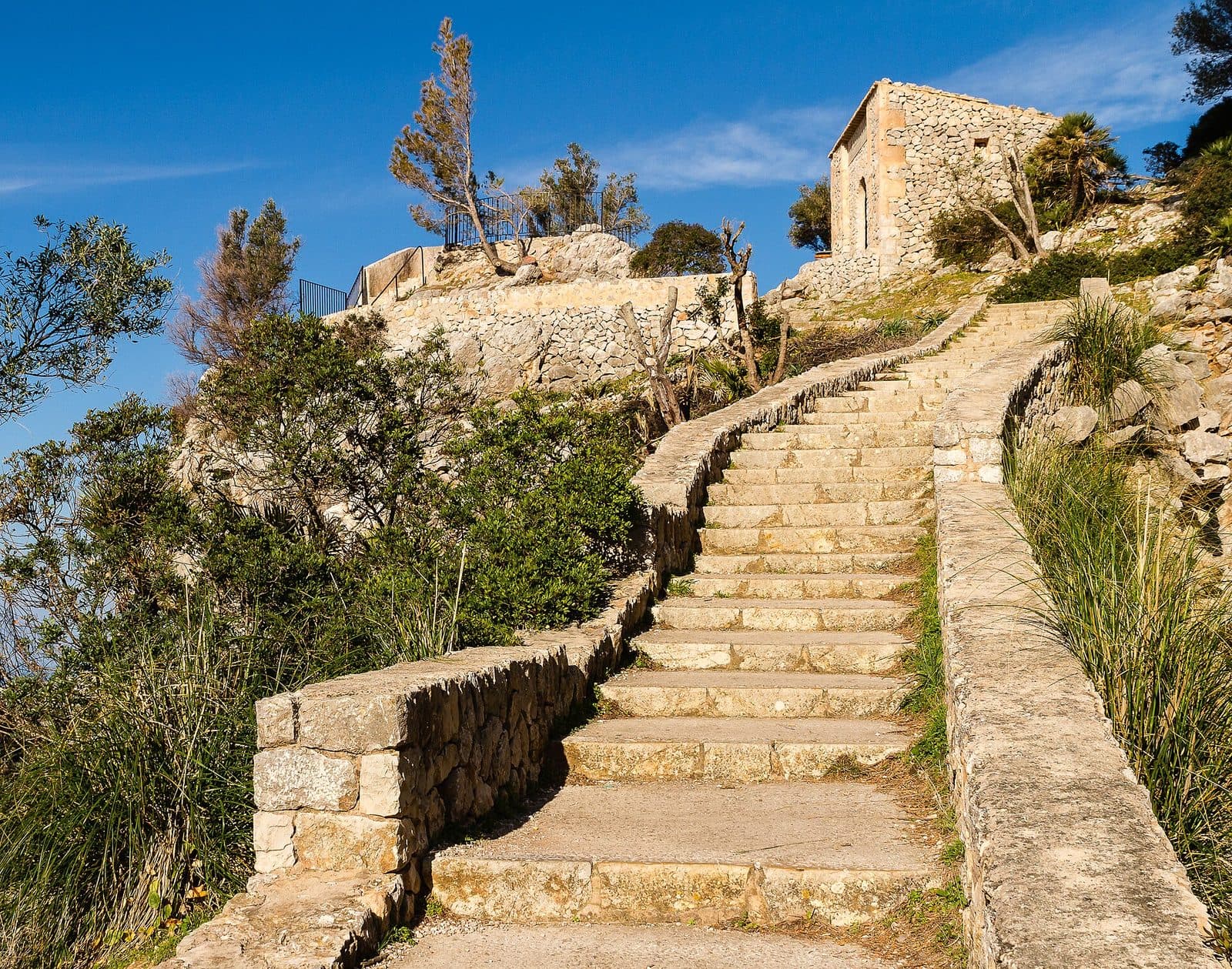

Mirador des Grau rewards a short detour from the winding coastal road with sweeping views across the Mediterranean and Mallorca’s rugged western side. The viewpoint lies on the stretch of coast near Banyalbufar and Estellencs, where the Serra de Tramuntana drops steeply into the sea and the Ma-10 repeatedly shifts between rock, woodland, and open slopes.
On maps and in travel reports, the site also appears under the name Mirador de Ricardo Roca. This refers to the viewing platform at Es Grau, not a nature park with a similar name or another viewpoint on the island. Travelers on the Ma-10 will recognize the stop primarily by the parking areas, the neighboring restaurant, and the short climb to the platform.
The strength of the viewpoint does not lie in an extensive sightseeing program. There is no large exhibition and no circular route with a series of stops. Instead, everything centers on a single moment: the road recedes, the landscape opens up, and beyond the rocky edge, the dark flanks of the Tramuntana meet the open sea. This makes Mirador des Grau a good destination for travelers who want to break up a drive along the west coast, take photographs, or consciously appreciate the landscape.
Even without a longer hike, the viewpoint provides an impressive sense of the topography on this side of the island. The platform is reached quickly, although the route requires climbing steps. It is equally suitable for a short break or a longer stay late in the day, when the light falls at a lower angle across the coast and water.
What to See
The Viewing Platform
The platform sits on a rocky outcrop above the western coast. From road level, the access route leads up a set of easily manageable steps. The climb is not long, but it changes the perspective considerably: vehicles and the roadside fade into the background while the sea and mountain slopes take over the view. This abrupt transition is precisely what makes the place so appealing. Only a few steps separate an ordinary driving break from a panorama that reveals the shape of the coastline.
At the highest point, the view is not focused on a single structure but on the interplay of rock, mountains, and the Mediterranean. The coastline here appears neither flat nor regular. Headlands, inlets, and rising slopes are layered behind one another, revealing several levels of terrain depending on visibility. The sea forms a calm, largely unobstructed expanse in front of them. In clear air, the contours appear sharper; hazy weather reduces the distant views but can emphasize the nearby rock formations.
The Mirador is occasionally described as an observation tower. For visitors, however, the important feature is the open platform on the rocky terrain. The available descriptions do not provide evidence of a historically documented construction sequence or a clearly verified former use as a tower. The site should therefore not be confused with Torre des Verger, the preserved historic watchtower farther along the coastal route.
Views of the Coast and Sea
The most rewarding direction to look is along the mountainous west coast. From here, it becomes particularly clear why road journeys in this part of Mallorca take time despite relatively modest distances: the slopes descend steeply, the coastline repeatedly recedes, and the road must adapt to the terrain. In a sense, the Mirador provides the overall picture behind the individual bends negotiated just moments before.
For photography, it is worth avoiding placing only the sea in the center of the image. The panorama becomes more expressive when part of the rocky outcrop or a rising coastal slope serves as the foreground. This makes the height and steepness of the viewpoint above the coast visible without the photograph consisting exclusively of water and horizon. Visitors who try several perspectives will also discover that the layered mountain ridges overlap differently depending on where they stand on the platform.
Later in the day, the atmosphere changes. Lower-angle light emphasizes the shapes of the slopes, while the surface of the water may appear brighter. Sunsets therefore attract particularly large numbers of visitors. The experience does depend on cloud cover and visibility, but the viewpoint retains its appeal even without a completely clear horizon because the dramatic coastal formations lie directly in front of the platform.
Road, Tunnel, and Rock
The location beside a mountain road is also part of the character of Mirador des Grau. A tunnel on the Ma-10 runs in the immediate vicinity. It is not a separate attraction, but it demonstrates how closely the road and rock are intertwined along this section. The view does not begin only at the top: as soon as visitors stop, it becomes clear that the Mirador occupies a narrow transition between the mountainside and the coastal drop-off.
This setting distinguishes it from viewpoints in town centers or on broad promenades. The Mirador is a compact roadside stop. The panorama is vast, but the actual space available to visitors is limited. This becomes noticeable when visitor numbers rise: people do not spread across extensive grounds but gather at a few favorable vantage points. Anyone who wants to take photographs in peace should therefore wait for a moment rather than immediately settling at the first available spot.
Visiting the Viewpoint
From the Roadside to the View
A visit usually begins as a break during a drive on the Ma-10. After parking, the route leads from the roadside area to the steps and up onto the rocky outcrop. No lengthy preparation is necessary, but traffic around the parking areas should be watched carefully. Especially when several vehicles arrive or depart at the same time, the transition between the parking area, road, and access point is the busiest part of the visit.
At the top, visitors are free to set their own pace: first take in the coast, then find a quieter position for photographs, and finally change the direction of view along the mountain slopes. Because there is no exhibition or prescribed route to determine the rhythm, the visit can remain very short. Anyone who only wants to see the view and take a picture does not need a long sightseeing period. Those waiting for better light, seeking different compositions, or deliberately extending their driving break will naturally stay longer.
Current opening hours and an admission fee have not been recorded. As accessibility and local regulations may change, it is advisable to check the current situation before traveling there. The Mirador should not be planned as a staffed attraction with a ticket office, scheduled tours, or a visitor center. Its main feature is a compact viewing platform beside the coastal road.
Quiet Hours and Popular Light Conditions
During the summer season, the Mirador and the neighboring restaurant can become busy. Tour groups and day-trippers use the same stop, so the parking areas and platform may be more crowded at times. Late in the day is particularly popular: the warm, low-angle light is ideal for coastal photographs, and the west-facing view makes the site attractive for sunsets.
Visitors primarily seeking peace and quiet are better advised to come outside this popular period. It is then easier to choose a spot at the edge of the platform and observe the layered coastline without people constantly moving in front of the camera. Those coming specifically for the evening light should allow extra time and avoid arriving at the last moment. The limited parking situation can become the decisive factor at precisely that time.
The weather also deserves attention. In clear conditions, the view extends far along the coast; haze softens distant contours. Strong winds are more noticeable on an exposed rocky outcrop than beside the more sheltered road. After unsettled weather, the steps and rocky areas may require particular caution. The viewpoint remains an outdoor stop in steep terrain, not a covered attraction.
Who Will Enjoy the Stop
Mirador des Grau offers the most to travelers who are already journeying between Banyalbufar, Estellencs, and Andratx. It fits well into a day on the Ma-10 because it requires little effort while the panorama explains what makes this road so special in scenic terms. Photographers will find clear coastal lines and a broad horizon; for hikers or cyclists, the site can provide a brief scenic break, provided the route and traffic situation are taken into account safely.
Those expecting a major attraction with historic interiors, food and drink directly on the platform, or a long nature trail will misunderstand the character of the place. Mirador des Grau is not a full-day program in itself. It works best as a memorable stop that is given enough time but sensibly combined with the coastal route or a visit to Banyalbufar.
Getting There and Parking
Taking the Ma-10 to the Viewpoint
The Mirador lies on the Ma-10, the winding road along the western Serra de Tramuntana. In this section, it connects Andratx with Estellencs and Banyalbufar. The viewpoint is located south of Estellencs in the Es Grau area. Visitors arriving from Banyalbufar follow the Ma-10 through Estellencs and continue toward Andratx. From the opposite direction, the Mirador lies before Estellencs.
When planning the journey, it is important to distinguish between the calculated route data to Banyalbufar and the final section to the viewpoint. From Palma Airport, the route follows Ma-20, Ma-1110, and Ma-1120 to Banyalbufar. It covers 39 road kilometers, and the drive takes around 77 minutes. From central Palma, the journey via Ma-1110, Ma-1120, and Ma-10 covers a total of 34 road kilometers to Banyalbufar; the drive takes around 82 minutes.
These figures expressly end in Banyalbufar, not at Mirador des Grau. From there, the final section follows the Ma-10, initially toward Estellencs and then farther south. It is a scenic but winding mountain road. When planning the day, the Mirador should therefore not be treated as though it were located directly in the center of Banyalbufar.
Parking at Es Grau
There are small parking areas near the viewpoint on both sides of the road; one is beside Restaurant Es Grau. This is convenient, but it does not mean that a space will always be available immediately. During the summer season and around sunset, restaurant guests, tour groups, and visitors to the Mirador may all arrive at the same time.
Patience is advisable when entering and leaving. The Ma-10 is not a broad access road to a large visitor parking lot here but a mountain route with continuous traffic. Sudden braking, turning around, or waiting on the carriageway should be avoided. If the nearest parking area is full, trying again later is more sensible than parking unsafely at the roadside.
From the parking area, visitors walk to the entrance to the platform. Because the parking areas, restaurant, road, and viewpoint all meet within a confined space, camera equipment and personal belongings should ideally be organized before setting off. This keeps time spent in the traffic area short and allows attention to remain on the road when crossing or walking alongside it.
Arriving by Bus
Within the broader corridor around Banyalbufar are the stops Planícia, Torre des Verger, Banyalbufar 1, and Banyalbufar 2. They provide access to destinations along the coastal region but do not automatically replace planning for the final route to the Mirador. Before traveling, visitors should check the current service, the appropriate stop, and a safely walkable connection to the viewpoint.
Especially on the Ma-10, an apparently short remaining distance on foot should not be equated with walking along an urban sidewalk. Bends, gradients, and the available road space determine whether a section can reasonably be covered on foot. Anyone traveling without a car should therefore not choose solely according to the nearest stop but should clarify the entire connection in advance, including the return journey and final access route.
Bus lines to Mirador des Grau at a glance
| Line | Route | Departures/day | First | Last |
|---|---|---|---|---|
| 202 | Estellencs - Palma | 202 | 06:37 | 21:31 |
| 131 | Santa Ponça - Banyalbufar | 18 | 11:12 | 16:23 |
From the official GTFS feeds (TIB/SFM), no real-time data. The figures cover all stops in the town; weekend and holiday services differ — check with the operator before travelling.
Getting there by bus
Planícia (7014) · 0.7 km as the crow flies
- 131Santa Ponça - Banyalbufar · Daily
- 202Estellencs - Palma · Daily
Torre des Verger (7004) · 1.1 km as the crow flies
- 131Santa Ponça - Banyalbufar · Daily
- 202Estellencs - Palma · Daily
Banyalbufar 1 (7002) · 1.7 km as the crow flies
- 131Santa Ponça - Banyalbufar · Daily
- 202Estellencs - Palma · Daily
Banyalbufar 2 (7003) · 1.8 km as the crow flies
- 131Santa Ponça - Banyalbufar · Daily
- 202Estellencs - Palma · Daily
Miramar 1 (7015) · 2.1 km as the crow flies
- 131Santa Ponça - Banyalbufar · Daily
- 202Estellencs - Palma · Daily
Miramar 2 (7006) · 2.1 km as the crow flies
- 131Santa Ponça - Banyalbufar · Daily
- 202Estellencs - Palma · Daily
Can Rave 1 (21009) · 2.3 km as the crow flies
- 131Santa Ponça - Banyalbufar · Daily
- 202Estellencs - Palma · Daily
Can Rave 2 (21006) · 2.3 km as the crow flies
- 131Santa Ponça - Banyalbufar · Daily
- 202Estellencs - Palma · Daily
Timetable data: official GTFS feeds (TIB/EMT), no real-time — check with the operator before travelling.
Nearby Places
Banyalbufar
Banyalbufar provides a cultural counterpoint to the open rocky coast at the Mirador. The village lies on a slope of the Serra de Tramuntana and is known for its tiered agricultural terraces. These so-called Marjades were built into the steep terrain with dry-stone walls, making agriculture possible where there is hardly any level ground. Vines, especially the Malvasía tradition, remain part of the village’s identity today.
A walk through Banyalbufar presents the landscape from a different perspective than the Mirador. Instead of one vast panorama, the impression is shaped by narrow streets, houses on the slope, and recurring glimpses of the sea. Combining both places reveals how closely settlement, agriculture, and terrain are intertwined. The viewpoint shows the broad shape of the coast; the village demonstrates how people used these steep slopes and made them habitable.
Cala Banyalbufar can also be included in a longer excursion. However, the descent to the coast requires separate planning for time and route and should not be treated as a casual extension of the brief stop at the Mirador. For a balanced day, it makes sense to explore the village and its terraces first and then choose the viewpoint as a scenic conclusion to the drive.
Estellencs and the Coastal Route
Estellencs lies closer to the Mirador and is suitable as another peaceful stop on the Ma-10. The village is smaller than many well-known destinations in the Tramuntana and retains the character of a mountain village on the west coast. Combining the two is especially appealing when the goal is not to collect as many sights as possible but to leave enough time for the road, the villages, and the changing views.
North of Estellencs, the route continues toward Banyalbufar. To the south, the Ma-10 continues to Andratx. This means the Mirador can be included either in a simple return trip or in a longer tour through the southwest. The road itself is part of the experience but requires concentration. Frequently stopping spontaneously in unsuitable places is not a good alternative to using designated viewpoints.
Torre des Verger
Torre des Verger is a natural addition for anyone who wants to see a preserved historic coastal watchtower as well as the landscape. However, it should not be confused with Mirador des Grau. While the open viewing platform and rocky outcrop are the focus at the Mirador, Torre des Verger is a separate structure at another point along the Ma-10.
Together, the two places tell the story of the exposed coastal setting in different ways. The Mirador provides an immediate, easily accessible scenic break; the tower adds a historic dimension. Combining them requires sufficient time for the winding drive and the parking situation at each site. A tight schedule takes away precisely what makes this route worth seeing: the changing perspectives between mountains and sea.
The place it belongs to
Banyalbufar in the place guidePractical Information for Your Visit
Shoes and Clothing
Sturdy, secure footwear is advisable for the short climb. The steps are considered easy to manage, but the site remains a rocky viewpoint rather than a level waterfront promenade. Careful footing is particularly important after wet weather. Loose sandals or smooth soles are less suitable for terrain where different surfaces meet between the parking area, steps, and platform.
Wind can be more noticeable on the rocky outcrop than in the parking area or beside the restaurant. A light additional layer is therefore useful even when it feels warm in the sheltered roadside area. At the same time, the open platform offers only limited protection from the sun. A hat, water, and sun protection are particularly useful when the stop is combined with other places along the Ma-10.
Visiting with Children
For children, the Mirador is more interesting as a short scenic stop than as a lengthy attraction in its own right. The steps provide a brief opportunity for movement, and the combination of mountains, sea, road, and tunnel is easy to appreciate. Adults should, however, consider the proximity to the carriageway and the exposed position of the viewpoint from the outset.
On arrival in particular, attention should not already be focused on the camera or panorama. The roadside area is the part of the visit that requires clear rules. Children should also be closely supervised at the top. For families also visiting Banyalbufar or Estellencs, the short stop can be incorporated easily into the day without overwhelming children with a long sightseeing program.
What Not to Expect
Mirador des Grau is neither a museum nor a developed visitor center. There is no documented permanent exhibition, no signposted route through several rooms, and no extensive historic complex. The name Mirador de Ricardo Roca, which appears on many maps, refers to the same viewpoint; it should not create the expectation of finding a large memorial site here.
The neighboring restaurant should also be distinguished from the viewpoint itself. Restaurant Es Grau can serve as a landmark and an addition to the break, but it is not part of the actual platform. Anyone coming exclusively for the panorama does not need to plan a long visit. Those wishing to combine evening light, photography, and a meal should, however, take the higher demand and limited parking into account.
Local insider tips
Use the Rock as a Foreground
For expressive coastal photographs, do not capture only the sea and horizon. Including part of the rocky outcrop or a rising mountain slope in the foreground shows the exposed location and gives the panorama greater spatial depth.
Arrive Before the Evening Light
Late in the day is particularly popular because of the low-angle light and west-facing view. Anyone wishing to take photographs should arrive earlier, before the parking area and platform become busier with sunset visitors.
Look for the Name Ricardo Roca
On maps and in directions, Mirador des Grau frequently appears as Mirador de Ricardo Roca. Both names lead to the viewpoint at Es Grau on the Ma-10 south of Estellencs.
Combine It with Banyalbufar
The stop makes the most sense when combined with Banyalbufar: in the village, dry-stone terraces show how the steep slopes were used; afterward, the Mirador provides an overview of the broad shape of the same coastal landscape.
Do Not Force a Parking Space
The parking areas near Es Grau are small and may be full during the summer season. Rather than turning around spontaneously on the mountain road or stopping unsafely, trying again later is the calmer option.