
Platja d'es Trenc – Natural Beach in Southern Mallorca
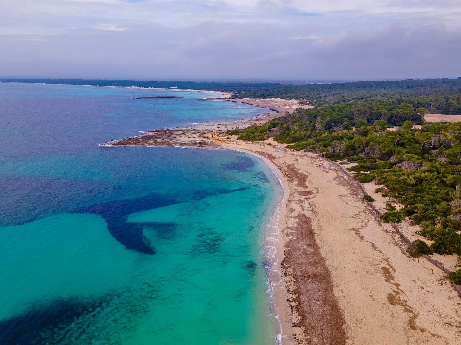

Platja d'es Trenc is one of those places where Mallorca’s southern coast suddenly feels remarkably expansive. Pale sand stretches along the open sea, the water remains shallow across wide areas, and dunes and low vegetation shape the horizon instead of an unbroken row of hotels. The beach lies within the protected Es Trenc-Salobrar de Campos natural area between Sa Ràpita and Colònia de Sant Jordi. Es Trenc is best known for its combination of fine sand, clear water and a largely undeveloped coastal landscape. Anyone expecting an urban beach with a promenade, abundant restaurants and every service close at hand will deliberately find something different here: a long natural beach whose beauty comes precisely from its open, comparatively sparsely developed surroundings.
The gently sloping shore makes Platja d'es Trenc attractive to families and anyone planning a relaxing day by the sea. At the same time, the area appeals to nature enthusiasts, walkers and visitors who pay attention not only to the sea but also to the landscape behind it. Beyond the beach are dunes, wetlands and salt pans where sea salt is still produced today. In summer, however, this setting is shared with many other visitors. Es Trenc is no longer a hidden secret beach but one of the best-known destinations in southern Mallorca. With an early arrival, sun protection and realistic expectations, a visit nevertheless remains an impressive experience.
History and significance
An orally transmitted story even connects the beach’s name with a powerful natural event. The Mallorcan word “Trenc” can be understood roughly as a break or breach. According to local tradition, a tsunami caused by the Lisbon earthquake cut through the dune barrier between the sea and the wetland in the middle of the 18th century. Whether the name truly derives from this exact event remains part of local tradition, but the story vividly illustrates how closely the coast, dunes and Salobrar are connected.
Salt production behind the beach
Long before Es Trenc became an internationally known swimming destination, salt shaped the landscape. Accounts trace the use of suitable waters for salt production back to Roman times. Salt pans still lie behind the beach today, where seawater evaporates and salt is harvested. Their geometric basins form a striking contrast with the irregular line of the dunes and coast.
The salt pans are not merely a historical addition to the beach. They form part of a landscape system in which human activity and the natural environment coexist. The shallow water in the basins and the neighbouring wetland provide habitat and resting places for numerous birds. For anyone looking at Es Trenc, this means the interesting landscape does not end beyond the sand but continues in a completely different form.
From bathing spot to protected natural area
The defining value of Es Trenc today lies in its preserved sequence of sea, beach, dunes and wetland. Es Trenc-Salobrar de Campos Natural Park protects both terrestrial and marine areas. According to the Balearic government, these include Posidonia meadows, foredunes and stabilised dunes, coastal ponds, pine and juniper stands, and the Es Salobrar de Campos wetland.
This history of protection explains why Platja d'es Trenc, despite its fame, does not resemble a continuously urbanised resort beach. Tall buildings and an unbroken promenade are absent from long sections. Rules protecting the dunes are therefore not incidental restrictions but essential conditions for preserving the beach’s character. Visitors experience not only a place to swim but also the visible edge of a sensitive coastal system.
What to see
Even from the sand, the landscape can be read in bands: first the pale shore gently descending into the sea, then the dune barrier, and farther inland the wetland and salt pans. No single structure defines the visit. The attraction is the interplay between these zones—and the changes left on the beach by water levels, wind and washed-up plant material.
The long sandy beach
Platja d'es Trenc extends along the coast between Sa Ràpita in the northwest and Colònia de Sant Jordi in the southeast. Its character varies depending on the access point: some areas are closer to settlements or parking facilities, while others feel considerably more open after a walk. In the northern section, rockier and more unspoilt stretches appear in places.
The sand is pale and fine, and in calm weather the sea displays the clear blue and turquoise shades for which Es Trenc is famous. Because the shore usually slopes only gently, the water remains shallow for a long distance near the coast. This creates broad bands of bright colour, especially when the sun is high. Sand, Posidonia and smaller stony areas alternate across the seabed.
Washed-up seagrass can temporarily change the postcard view. It is not necessarily rubbish but often consists of remains of Posidonia oceanica, an ecologically important marine plant. These deposits are part of a natural beach and help retain sand along the coast. Anyone who regards Es Trenc only as an immaculately cleared swimming beach overlooks an essential part of its natural dynamics.
The dunes
A sensitive belt of dunes begins behind the beach. Foredunes, more firmly established areas, and pine and juniper growing on consolidated dunes all form part of the protected system. The plants slow the wind and bind the sand with their roots. What may appear inconspicuous therefore performs an important role in stabilising the coast.
The dunes should only be crossed using designated access points and paths. Shortcuts through the vegetation damage the very structures that protect the beach from erosion. Even for photographs, the best viewpoint is not in the middle of the dune grass but at the edge of approved paths or directly from the beach. From there, the characteristic sequence of sand, low vegetation and open sky remains clearly visible.
The shallow sea and Posidonia meadows
The protected natural area does not end at the waterline. Significant stands of Posidonia oceanica lie off the coast. These underwater meadows provide habitat, stabilise sediment and contribute to the water’s clarity. Darker patches below the surface are therefore not necessarily rocks or pollution but may indicate vegetated areas of the seabed.
When the water is calm, the clear, shallow coastal zone is suitable for swimming and exploring with a mask and snorkel. Conditions change, however, with the wind and sea state. Es Trenc is exposed to the open sea, so calm water should never be treated as a permanent guarantee. The actual conditions on the day of the visit must always be considered before swimming.
Es Salobrar and the salt pans
Farther inland lies Es Salobrar de Campos, an important wetland. Together with coastal ponds, salt basins and agricultural land, it provides a habitat for migratory and resident bird species. Publications about the landscape mention 171 species of birdlife. Particularly during migration periods, this gives the flat plain a significance extending far beyond swimming.
The salt pans can be recognised by their straight-edged basins, embankments and changing water colours. Sea salt continues to be produced here, and the well-known Flor de Sal is skimmed from the surface. The beach and salt production are therefore not separate stories. Both depend on the same combination of seawater, sun, wind and an exceptionally flat coastal landscape.
The open coastline
One often underestimated feature of Es Trenc is its unobstructed view. Tall buildings that frame many other resort coasts are absent from large sections of the beach. As a result, the sky and sea remain the dominant expanses. In the morning, the water often appears clear and bright, while the late-day light gives the sand a warmer colour and brings the contours of the dunes into sharper relief.
This openness also means there is little natural shade. The low vegetation behind the beach is not a place to sit, and the protected dunes must not be used as an alternative resting area. Anyone planning to stay longer should therefore take the open nature of the landscape seriously in practical as well as photographic terms.
Visiting Platja d'es Trenc
The first impression depends greatly on when and through which access point you arrive. Early in the day, visitors often find large, peaceful areas of sand ahead of them. As a sunny summer day progresses, the easiest-to-reach sections in particular fill up, and access roads and car parks can become congested. Late afternoon often brings more space again, along with softer light.
From the access point to the beach
Official access to the natural park is available through Sa Ràpita, Ses Covetes and Colònia de Sant Jordi, as well as from the Na Tirapel car park. The best option depends on the desired section of beach. Platja d'es Trenc is long, and an access point at one end does not automatically provide a convenient route to a more distant part of the beach.
From the car park or edge of the settlement, designated paths and crossings lead on foot to the sand. The final stretch is part of the experience: the coast suddenly opens up beyond the low vegetation, and only then does the beach’s full length become visible. The return journey should be considered when planning a long walk, as progress over soft sand is slower than along a promenade.
Swimming or walking along the beach
For a brief introduction, a walk to the water, a swim and a look at the dunes are sufficient. Anyone wanting to experience the beach’s different landscapes should stay considerably longer and walk part of the coastline. A full day at the beach is equally possible, although the limited shade and infrastructure require more preparation. The water is shallow across much of the shore, so it is often possible to wade a good distance into the sea. Families appreciate this feature, but it is no substitute for supervision, particularly because wind, waves and currents can change.
Crowds and time of day
On summer weekends, Es Trenc is one of Mallorca’s busiest natural beaches. Anyone seeking a quieter impression of the landscape should arrive as early as possible. Not only is finding a parking space generally easier then, but the transitions between empty sand, dunes and water are also more apparent. Late afternoon is a good alternative when the day’s largest crowds begin to subside.
Outside the main swimming season, Es Trenc is quieter and feels more unspoilt. The beach then becomes more of a destination for walks and nature observation. Regardless of the season, Platja d'es Trenc is accessible around the clock. However, this does not mean that car parks, beach services or other facilities are available at all times.
Getting there and parking
The longer journey first leads to Sa Vinyola. From Palma Airport, the road distance is 44 kilometres; the drive takes around 42 minutes via the Ma-19 and then the Ma-6030. From central Palma, the road distance to Sa Vinyola is 50 kilometres. Allow around 52 minutes, also travelling via the Ma-19 and the Ma-6030.
These distances and journey times explicitly end in Sa Vinyola, not directly at a spot for your towel on Platja d'es Trenc. For the final section, follow a local road towards the coast according to the chosen beach access point. Official access is available through Sa Ràpita, Ses Covetes, Colònia de Sant Jordi and the Na Tirapel car park. The choice should be made before setting out because the elongated beach has more than one entrance.
Parking at the natural beach
Parking is available at several access points, and spaces close to the beach may require payment. They fill quickly during the high season and on summer weekends. Arriving early reduces the risk of traffic congestion and a lengthy search for parking. Unauthorised parking along the roadside is not a good alternative, particularly because access routes and sensitive areas must be kept clear.
A walk generally remains between the parking space and the beach, with its length depending on the car park and desired section. Travelling light therefore pays off: cool bags, parasols and swimming equipment must be carried along paths and sometimes over sand. Visitors travelling with children should take this final stretch into account when packing.
Arriving without a car
No bus stop is recorded in the immediate vicinity of the attraction. Visitors should therefore not assume that a regular bus will provide spontaneous transport directly to the beach. Services to surrounding towns and seasonal timetables can change and must be checked before visiting. It is also important to remember that a walk may still be required between a stop in town and the desired section of beach.
Nearby places
Sa Vinyola lies in the southern part of Mallorca and serves as the destination in the travel data before local roads continue to one of the beach access points. Platja d'es Trenc itself extends along the coast of the municipality of Campos between Sa Ràpita and Colònia de Sant Jordi. Consequently, not every coastal town is equally convenient for the same section of beach.
Sa Ràpita and Ses Covetes
Sa Ràpita marks the northwestern part of the long sandy coast. Access from there is suitable for visitors who want to combine Es Trenc with the town and the adjoining stretch of coastline. Ses Covetes lies farther southeast and provides another official entrance to the natural park. Both access points lead into the same extensive beach landscape, but development, paths and distance from the central sections create different impressions.
Colònia de Sant Jordi
At the southeastern end, Colònia de Sant Jordi forms a more urban counterpart to the open natural beach. The town has a harbour and is suitable for combining a beach visit with a walk by the water or a meal. Es Trenc can also be reached on foot along the coast from here, although the route crosses sand and sufficient energy should be reserved for the return journey.
Salt pans and wetland
The most natural addition to a day at the beach is not another attraction but a closer look at the landscape behind it. The salt pans and Es Salobrar explain why Es Trenc is ecologically more than a beautiful place to swim. Anyone interested in salt production can combine a beach visit with an activity offered by the salt works; tours have their own conditions, which should be checked in advance.
Campos and Ses Salines are suitable additional stops in the south of the island. Their more rural appearance contrasts with the busy coastal strip. For a single excursion, however, it is usually enough to combine Es Trenc with one of the neighbouring coastal towns or the subject of salt. Too many destinations would detract from the appeal of this long, leisurely day at the beach.
The place it belongs to
Sa Vinyola in the place guidePractical tips for visiting
The open sky is part of Es Trenc’s beauty—and its main practical challenge. Natural shade is scarce on the beach. Sun protection, a hat and sufficient drinking water should therefore be packed even for a shorter stay. The protected dunes are not a place to seek a shady spot among the vegetation.
Footwear and luggage
Normal beach shoes or sandals are sufficient for the beach itself, but there may be a longer walk between the car park, access point and chosen spot. Comfortable footwear is particularly useful when planning a walk along the coast. Heavy bags quickly become burdensome on soft sand, and compact equipment is generally more convenient than extensive beach furniture.
Visiting with children
The water slopes gently across most of the beach, which benefits families because children have ample room to splash in the shallows near the shore. Nevertheless, Es Trenc is an open sea coast. Supervision, sun protection and attention to wind and wave conditions are essential. Soft sand can make using a pushchair difficult, so the shortest possible route to the desired section should be considered when choosing an access point.
Seagrass and the natural beach
Posidonia remains along the shore are a natural part of the coastal system. Their quantity changes with the weather and season. Anyone expecting an entirely cleared stretch of sand may therefore be disappointed. From an ecological perspective, the deposits are valuable: they slow the loss of sand and demonstrate the connection between the offshore seagrass meadows and the beach.
Respecting the protected area
Dune vegetation must not be entered or used as a shortcut. Designated crossings protect plants and prevent the creation of ever more informal paths. Rubbish should be taken away, especially when few services and disposal facilities are available in the chosen section.
Expect a long sandy beach, open sea and a valuable coastal landscape. Do not expect an unbroken promenade, shade everywhere or the comprehensive infrastructure of an urban beach. Yet these very limitations preserve the character for which Platja d'es Trenc is visited.
Local insider tips
Get to the beach early
In the morning, car parks and access points are generally less busy, and the open beach landscape feels more peaceful. Anyone who wants to experience Es Trenc not only as a place to swim but also as a natural area should begin the day here.
Use designated crossings only
The best views of the dunes and sea are available from approved paths and the beach. Stepping into the dune grass damages the roots; a shortcut through the vegetation is neither necessary nor permitted for photographs.
Look out for the salt pans
On the way there, it is worth looking beyond the dunes: the straight-edged salt basins form part of the history of Es Trenc and explain why this coast is simultaneously a swimming destination, wetland and salt-producing landscape.
Leave the seagrass where it is
Brown Posidonia remains are not ordinary waste. They protect the sand from erosion and form part of the natural coastal system. To find a clear place to swim, it is usually enough to walk a little farther along the beach.
Enjoy a late view across the beach
Anyone unable to arrive early will often find a calmer atmosphere in the late afternoon. The lower light brings out the contours of the dunes and patterns in the sand, while many day visitors are already leaving.