
puig de na Bauçana – Hike with Views of Western Mallorca
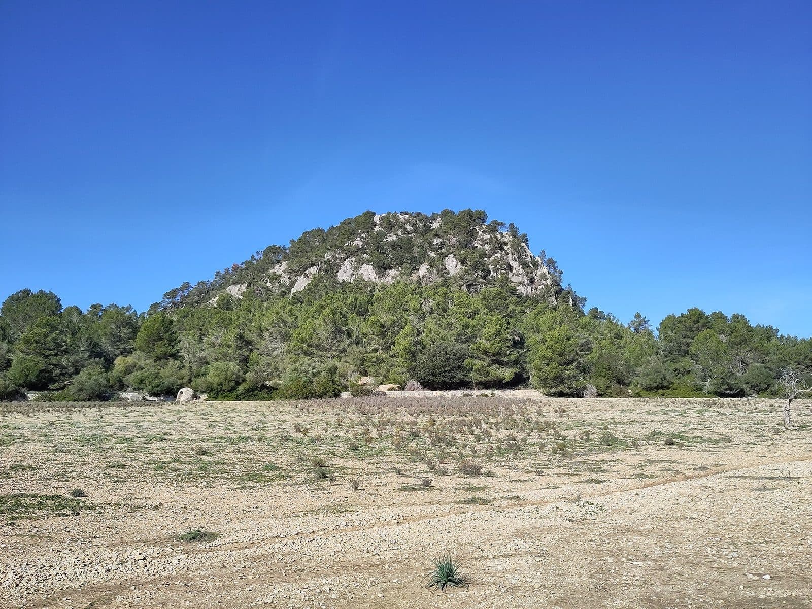

The real appeal lies in the route up: A forest track climbs above Puigpunyent and Galilea through the southwestern Serra de Tramuntana before the final section becomes rougher and a panoramic view of the mountains of western Mallorca opens up at the top. The summit is therefore primarily a destination for hikers. The established route is considered short enough for a morning and initially follows a good path through pine and holm oak forest. Only near the summit does the damaged older trail require more attention. This change is precisely what makes the outing interesting: A relatively peaceful forest ascent is followed by a distinctly more mountainous finale.
At the top, the landscape takes center stage. Na Bauçana serves as a natural lookout over the surroundings of Puigpunyent and Galilea; descriptions highlight a panoramic view of the western mountains of the Serra de Tramuntana. Anyone seeking a quiet mountain hike with a clear destination and equipped with sturdy footwear and sure-footedness for the final section will find a compelling alternative to the region’s better-known peaks here.
However, the puig de na Bauçana lies within the Possessió Son Cortei, a traditional Mallorcan estate. The established route therefore does not begin directly in the village and should be prepared carefully. Signage, property boundaries, and any current access notices must be observed before setting out.
History and Significance
From Albussa to Bauçana
The name preserves a piece of Mallorca’s Islamic past. The present-day Son Cortei estate was known as Alqueria Albussa during the Muslim period. The form Bauçana is said to have developed from this older place name over the centuries. The mountain’s name is therefore not merely a geographical designation but a linguistic trace of the era when estates and cultivated valleys shaped the area around Puigpunyent.
This origin suits the mountain landscape: Na Bauçana does not stand isolated beside an urban center but belongs to a rural area that has been worked for a long time. The summit lies within the Possessió Son Cortei. In Mallorca, “possessió” refers to a large country estate.
Son Cortei and the Route to the Summit
Another layer of history can be seen in the ascent itself. In the second half of the 20th century, Son Cortei belonged to Gabriel Alzamora, a Mallorcan businessman and politician who was also president of the Foment del Turisme de Mallorca. The specially prepared access route from Pla de Son Cortei to the summit is associated with this early tourism organization.
In the 20th century, the path was developed for excursionists. Traces of its former construction can still be seen in the upper section, but this is precisely where the route has deteriorated. The historic trail should no longer be mistaken for a well-maintained promenade: Its poorer condition explains why an initially easy woodland hike becomes more demanding shortly before the destination.
A Natural Lookout in the Tramuntana
Today, the significance of the puig de na Bauçana lies above all in its location. It forms a natural viewing platform above Mallorca’s western mountains and offers a perspective that is not limited to a single valley or peak. Descriptions mention a 360-degree panorama across the mountains of the island’s west.
What to See
The Forest Ascent
The first impression comes not at the summit but among the trees. From the area around Coll des Molí de Vent, the established access route initially follows a signposted path toward Calvià. After a metal gate with a stile, the route continues along a forest track that gradually gains elevation. Pines characterize this section, while holm oaks are also part of the mountain forest.
At first, the enclosed greenery removes much of the ascent’s high-mountain character. Instead of crossing bare slopes, the route leads through Mediterranean mountain forest, where views open intermittently between the trunks. Galilea in particular becomes visible along the way. The small village occupies an elevated position in the mountain landscape and provides a useful point of reference for the rest of the ascent.
The Old Summit Trail
At Pla de Son Cortei begins the section historically associated with the Foment del Turisme. The path specifically laid out to reach the summit was once more carefully prepared, but its upper section is now damaged. As a result, the terrain changes character: Comfortable walking on the forest track gives way to slower progress, with the surface and the correct route requiring greater attention.
Here in particular, it is worth looking at more than just the summit ahead. Remnants of the old route recall that this viewpoint was deliberately made accessible decades ago. What appears on the first few stretches to be an ordinary forest route thus has a cultural and historical detail that is easy to overlook: The trail forms part of the early tourism development of Mallorca’s mountain landscape.
The Summit Panorama
At the top, it becomes clear why this route was created. The puig de na Bauçana is regarded as an outstanding lookout over Mallorca’s western mountains. The panorama extends in every direction across the layered heights of the Serra de Tramuntana; rather than offering a single iconic photo subject, the summit provides an overview of the relief of the entire surrounding area.
The defining mountains around the Puigpunyent valley include Na Fàtima, Els Puntals, Es Piconar, and the Puig de Galatzó. The view from Na Bauçana helps visitors understand this mountain landscape as a connected whole. Galilea and the forested slopes below the summit provide smaller points of scale within the panorama and reveal how closely settlements, estates, and woodland lie alongside one another here. Anyone reaching the top should therefore allow time to get oriented: The panorama is better appreciated by slowly changing the direction of view than through a single quick photo stop.
Visiting
From Coll des Molí de Vent into the Forest
Coll des Molí de Vent on the Ma-1032 is named as the classic starting point. A public, signposted path begins there and generally continues toward Calvià. For the puig de na Bauçana, this route is followed only as far as a later junction. A metal gate with a stile forms part of the described route; beyond it, a forest track climbs through the woods in a southerly to southwesterly direction.
The first sections of the route are relatively straightforward. Nevertheless, it is advisable to check the route on an up-to-date hiking map beforehand, as the summit is not the final destination of the continuous path to Calvià. The crucial point is the turnoff toward Na Bauçana. Anyone who simply follows the long-distance direction will continue along the path without heading for the summit.
The Mountain Finale
The final section deserves more time than the broad forest track. The summit path prepared in the 20th century has deteriorated in places and is more difficult to walk. Progress can therefore slow considerably. Sturdy footwear, sure-footedness, and a willingness to turn back in unsuitable conditions are more important here than athletic speed.
At the summit itself, the panoramic view is the main attraction. Enough time should be allowed for a worthwhile break, as the panorama covers several directions and cannot be reduced to a single viewpoint. In poor visibility, the hike loses an essential part of its appeal; in clear conditions, by contrast, the broad overview of the western Tramuntana becomes the highlight.
Timing and Visiting Conditions
The route is described as an outing that can be completed within a morning. This is a more suitable guide than a tightly scheduled summit visit: The ascent, careful walking through the damaged upper section, a break for the views, and the return route all require their share of time. No individually binding duration can be derived from this, as fitness, trail conditions, and breaks have a major influence.
Specific opening hours and admission details are not recorded. Because the mountain lies within Son Cortei and only the first part of the described access route is explicitly identified as a public path, current access rules should be checked before visiting and notices on site must be respected. This applies particularly if gates, closures, or new signage differ from older route descriptions.
Getting There and Parking
From Palma to Puigpunyent
From central Palma, the route follows the Ma-1041 to Puigpunyent. The road distance is 21 kilometers, and the drive takes around 57 minutes. These details expressly apply only as far as Puigpunyent, not to the beginning of the mountain trail. The winding location at the edge of the Serra de Tramuntana explains why sufficient time should be allowed for this relatively short distance.
Puigpunyent is a useful first point of reference and a good place for a break before or after the hike. The traditional starting point at Coll des Molí de Vent lies outside the village center on the Ma-1032 between Puigpunyent and Galilea. The final stretch therefore continues along a mountain road to the area where the hike begins.
From Palma Airport to Puigpunyent
From Palma Airport, the drive to Puigpunyent covers 30 road kilometers. Via the Ma-20 and then the Ma-1041, it takes around 55 minutes. Here too, the measured route ends in the village. Additional time must be allowed for the onward drive to Coll des Molí de Vent and for orientation at the starting point.
Anyone wishing to set out directly after landing should not schedule the hike too tightly against the remaining daylight. Although the route is known as a morning outing, the damaged summit trail requires a time reserve. Before continuing, visitors should also establish whether the current route and access through Son Cortei are available.
Starting Point and Bus
The described trailhead is at Coll des Molí de Vent on the Ma-1032. Conques 1, Conques 2, and Galilea are listed as stops in the wider area. However, they do not automatically replace precise planning of the walk to Coll des Molí de Vent. Before traveling, check which service operates on the chosen day, in which direction each stop is served, and how the hiking start can be reached safely from there.
Bus lines to puig de na Bauçana at a glance
| Line | Route | Departures/day | First | Last |
|---|---|---|---|---|
| 201 | Galilea - Palma | 55 | 06:45 | 21:45 |
From the official GTFS feeds (TIB/SFM), no real-time data. The figures cover all stops in the town; weekend and holiday services differ — check with the operator before travelling.
Getting there by bus
Conques 1 (45007) · 0.5 km as the crow flies
- 201Galilea - Palma · Daily
Conques 2 (45008) · 0.6 km as the crow flies
- 201Galilea - Palma · Daily
Galilea (45004) · 1.2 km as the crow flies
- 201Galilea - Palma · Daily
Torrent d'en Faveta (45016) · 2.6 km as the crow flies
- 201Galilea - Palma · Daily
Timetable data: official GTFS feeds (TIB/EMT), no real-time — check with the operator before travelling.
Nearby
Puigpunyent
Puigpunyent lies in a green valley surrounded by several mountains of the western Serra de Tramuntana. The village makes a good peaceful counterpart to the hike: After the forest and the open summit views, a walk through its streets reveals a history closely connected with the old estates of the surrounding area.
Notable stops include the parish church l’Assumpció de Nostra Senyora. The present neoclassical building was constructed over an older Gothic church. Some of the village’s oldest houses stand nearby. The Pou Nou, or “New Well,” and the historic school building are also part of a local route for which, according to the municipality, about half a day should be allowed. When combining it with Na Bauçana, selecting only some stops is therefore preferable to completing the entire walk.
Galilea
Galilea accompanies the hike visually from an early stage. During the ascent, views open toward the elevated village, while the Ma-1032 continues from the starting area in its direction. This makes Galilea a natural scenic continuation of the outing without requiring a second extensive sightseeing program.
The value of this combination lies above all in the change of perspective. From the mountain, Galilea appears as part of the broad Tramuntana landscape; afterward, the slopes can be viewed from the level of the settlement. Those planning to travel by bus will also find Galilea among the stops in the wider area, but should check the actual connections and the walk to the trailhead for the relevant day.
The Mountains Around the Valley
Na Bauçana is only one of several mountains framing the Puigpunyent valley. Na Fàtima, Els Puntals, Es Piconar, and especially the Puig de Galatzó shape the surrounding relief. They should not be confused with the destination of this hike: The puig de na Bauçana has its own access route and its own value as a viewpoint.
For this reason in particular, it is worth avoiding an itinerary overloaded with too many additional mountain hikes. A short walk around Puigpunyent or a detour to Galilea fits better with the ascent described as a morning hike. This leaves enough time for the summit and for a careful return along the damaged upper trail.
The place it belongs to
Puigpunyent in the place guidePractical Information
Footwear and Navigation
The broad forest track at the beginning can create a misleadingly easy impression. Sturdy hiking boots are nevertheless the right choice for the full ascent, as the condition of the old summit path worsens in the final section. Grip, sure-footedness, and a controlled pace matter there. After rain or in poor visibility, the condition of the ground should be assessed particularly carefully.
An up-to-date hiking map or a reliably saved route makes navigation easier. The signposted public path at Coll des Molí de Vent generally leads toward Calvià; Na Bauçana is reached only via a turnoff. The signs for the main path alone are therefore no guarantee of finding the summit.
Sun, Forest, and Weather
Pine and holm oak forest provide shade on parts of the ascent. However, this does not mean that the entire route is protected from the sun. At the summit and in more open sections, the closed canopy is absent, while the panorama encourages visitors to stay longer in precisely these places. Water and sun protection therefore belong in the backpack even on a relatively short morning hike.
The panoramic view is the main objective of the hike. Before setting out, it is therefore worth checking visibility, cloud cover, and wind. In overcast mountain conditions, the forest path remains, but the view across the western Tramuntana—the defining part of the experience—is lost.
With Children
The hike is described as family-friendly and as a possible morning outing with children. This assessment relates to the manageable route and the predominantly good path, but it should not obscure the upper section. The damaged summit trail requires greater attention there and, depending on a child’s experience, may feel considerably more demanding than the forest track below.
Adults should therefore base their decision not only on the route’s length but also on sure-footedness, concentration, and current conditions. Allowing enough time for breaks and choosing an early turnaround point is more sensible than insisting on reaching the summit.
Access Information
The location within Son Cortei should be taken seriously. Gates and property boundaries are not invitations to take arbitrary shortcuts. The current route and notices on site are decisive. Those who accept these conditions will experience Na Bauçana at its most impressive: as a natural viewing platform above western Mallorca.
Local insider tips
Take Time to Read the Panorama
The summit offers a 360-degree panoramic view. Instead of photographing in only one direction, slowly changing position is worthwhile: Galilea, the forested slopes, and the western Tramuntana mountains form the complete picture only when seen together.
Look for Galilea During the Ascent
As the forest track climbs, views of Galilea open between the pines. This early point of reference later makes it easier to understand from the summit how the village lies among the mountains and forested slopes.
Save Energy for the Finale
Most of the route follows a good woodland path, but the old summit trail prepared in the 1960s is damaged in the upper section. A relaxed pace at the beginning leaves more concentration for this part.
See the Trail as a Piece of History
The upper trail is more than just an access route to the panorama. It recalls Gabriel Alzamora and the Foment del Turisme, which had the path prepared for excursionists in the 20th century.
Combine It with Puigpunyent
After the hike described as a morning outing, a short walk through Puigpunyent fits well. The church, old houses, and Pou Nou provide a concise cultural and historical conclusion to the nature experience.