
Punta de ses Crestes – Portocolom Lighthouse
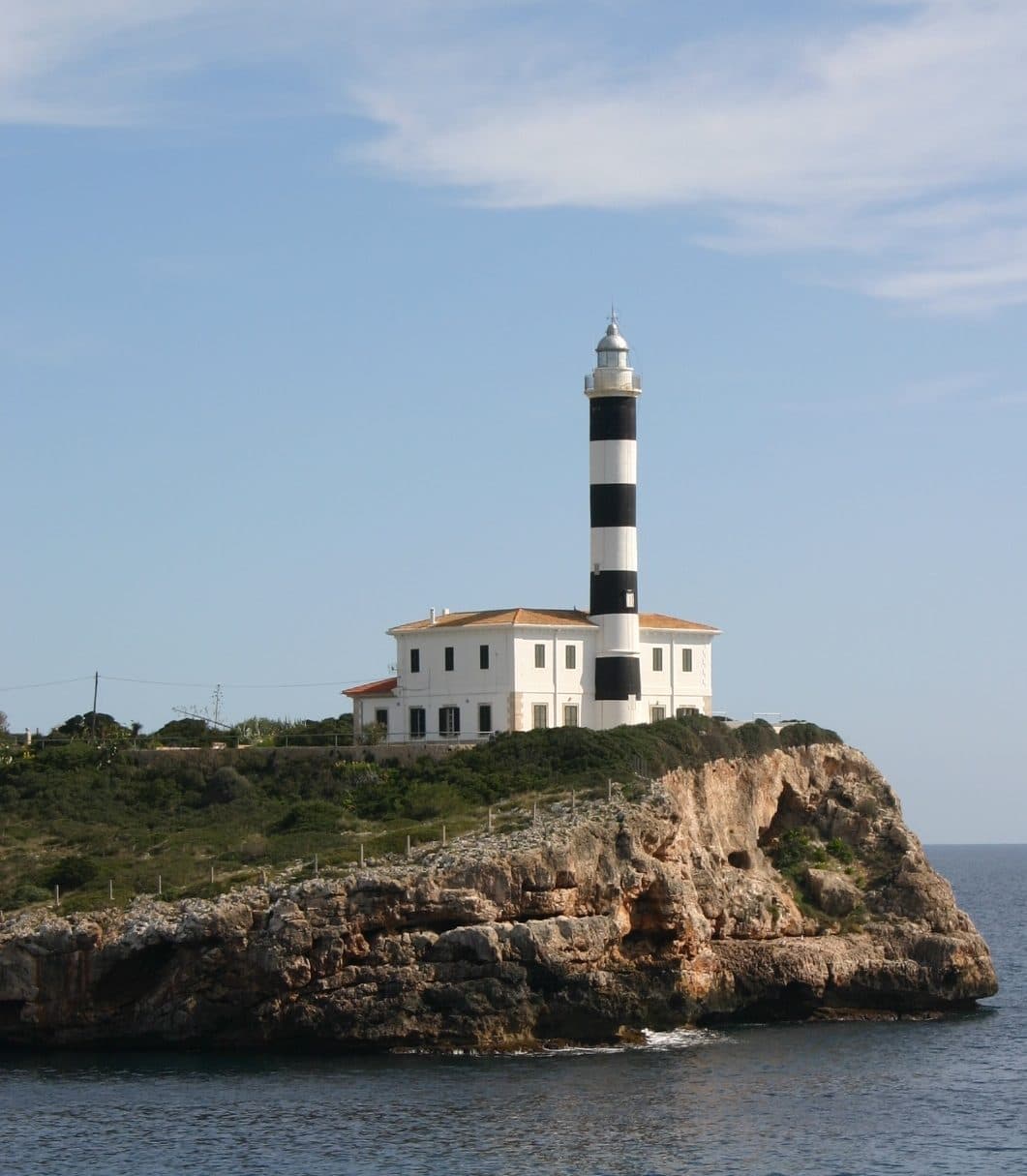

On the northeastern side of Portocolom’s broad harbor bay, Punta de ses Crestes forms a highly visible endpoint. The lighthouse, also known as Far de Sa Punta de ses Crestes or Portocolom Lighthouse, stands where sheltered harbor waters meet the open coast. This location is precisely what makes the site more interesting than a mere photo stop.
Seen up close, the point of its location becomes clear: The tower does not belong to the bustling center of the harbor but to a coastal landscape projecting out toward the sea. The route there leads out of town, past small stretches of shoreline and viewpoints. At the destination, the view extends back across the bay and out to sea at the same time – two very different sides of Portocolom in a single coastal scene.
The visit is worthwhile for lighthouse enthusiasts, walkers, and anyone who wants to discover more of Portocolom than its promenade. Punta de ses Crestes also works well as part of a longer coastal circuit.
History and significance
The light at Punta de ses Crestes was first lit in 1863. Its location was no coincidence: The headland lies on the northeastern side of the bay of Portocolom and, from a seaward perspective, marks the transition between the open coast and the harbor area.
The light of 1863
The date explains why the tower, despite its clearly recognizable function to this day, forms part of Mallorca’s historic infrastructure. It marked an important point on the coast and helped sailors identify the position of the bay in the dark.
This original purpose defines its historical significance. Its history is embedded in the location itself: in the line of sight across the water and the tower’s exposed position. Anyone walking from the harbor to the headland is, in a sense, following the reverse view of an arriving ship.
A harbor landmark
Over time, the lighthouse became not only a navigational marker but also a recognizable symbol of Portocolom. Its silhouette is frequently photographed and represents the town’s maritime character. Unlike an isolated lighthouse on a remote cape, Punta de ses Crestes remains closely connected to the bay. The tower marks the edge of the harbor without appearing detached from the town.
This dual significance makes it remarkable. For shipping, it identifies a point on the coast; for visitors, it brings order to the landscape. From the old harbor, it appears as a destination at the end of the bay; on the way to the headland, it becomes the dominant structure; and from the coast, it directs the view back toward Portocolom. The official archive of Balearic lighthouses accordingly lists it among Mallorca’s lighthouses.
What to see
The strongest impression comes not from a single architectural detail but from the interplay of tower, headland, and harbor entrance. Punta de ses Crestes can be viewed from several directions, and every section of the route changes the proportions. At times the lighthouse rises above the coastline; elsewhere it forms the endpoint of a long view across the bay.
The lighthouse
The tower is the unmistakable center of the complex. Its clear, functional form distinguishes it from the lower-looking buildings and surrounding coastal landscape. From some distance, it becomes particularly apparent why lighthouses are such effective landmarks: A single vertical structure is enough to give a low headland a clear point of orientation.
When viewing it, it is worth resisting the urge to focus solely on the tower. The wider context reveals more. On one side lies the broad bay of Portocolom; on the other, the open sea begins. The lighthouse stands exactly at this junction. Up close, it therefore appears less like a freestanding postcard subject and more like the functional focal point of an entire coastal position.
Punta de ses Crestes
Here, the geography of the harbor becomes easy to understand: The bay reaches far inland, while the Punta marks its northeastern edge. Anyone who has already walked through Portocolom can see from the headland area how strongly the town is shaped and divided by the water.
The view shifts between harbor and sea. Toward the bay, boats, waterfront buildings, and the sheltered expanse of water take center stage; seaward, the horizon opens up. This contrast is the visit’s real scenic appeal. It explains the choice of location more convincingly than any abstract description of navigational functions.
Punta d’es Babo
A mapped coastal route from Portocolom to Punta de ses Crestes also passes Punta d’es Babo. This section turns a visit to the lighthouse into a walk along several small coastal points. The tower remains the destination and point of orientation, but the route develops a character of its own: Instead of driving directly to it, visitors approach the light along the varied shoreline.
For visitors who enjoy photography, this approach is especially appealing. As the position changes, so do the distance to the tower, the visible course of the coast, and the proportion of the bay within the image. This produces more expressive views than a single photograph taken directly at the destination.
Arenal dels Ases and Arenal de ses Dones
Arenal dels Ases and Arenal de ses Dones also lie along the described route. These small stretches of shoreline show that the way to the lighthouse is not merely a section of road but a connection between several maritime places. With enough time, visitors can experience Punta de ses Crestes as the endpoint of a coastal exploration rather than simply as an isolated sight.
This sequence is precisely what sets the excursion apart from a conventional monument visit. The experience consists of sightlines, small coves, headlands, and the tower repeatedly reappearing along the way. The lighthouse provides the orientation, while the coast supplies the changing foreground.
Visiting Punta de ses Crestes
The first view of the tower does not have to be the best. Punta de ses Crestes reveals itself as you approach: first as a landmark on the edge of the bay, later as the destination at the end of Carrer del Far, and finally in relation to the coast. For a rewarding visit, it is therefore worth walking part of the way and viewing the location from different distances.
A direct detour
Those visiting the lighthouse as a standalone stop should follow Carrer del Far in Portocolom toward the headland. At the destination, the exterior is the main focus. Current access conditions should be checked before visiting; fixed opening hours and admission details are not reliably documented. An interior visit should therefore not be assumed to be part of the excursion.
For a short stop, it is enough to take in the tower and its setting before turning to the view across the bay. There is no universally applicable length of stay: Those who only want to see the structure will remain for much less time than visitors taking photographs or continuing to explore the coast.
The coastal circuit
The Portocolom–Punta de ses Crestes hiking route, rated moderate, takes more time. A walking time of around one to one and a half hours is given for this circuit. It begins at the parking area on Carrer del Far by Es Riuetó and passes several named coastal points, including Punta d’es Babo, Arenal dels Ases, and Arenal de ses Dones.
This option offers the more complete visitor experience. The lighthouse remains the highlight, but its location becomes easier to understand along the way. Attention is also distributed across the route: Small stretches of shoreline, the course of the bay, and recurring views of the tower ensure that the walk is more than a simple journey there and back.
Light and crowds
There is no reliable information on specific peak visiting times.
Good daylight is also essential: The impact of the location comes from the view and the spatial relationship between the tower, bay, and coast.
Getting there and parking
The journey from farther afield first leads to Portocolom. Only within the town does the final, much more local section toward the headland begin. Navigation should therefore be set not only to the town name but specifically to Punta de ses Crestes or Carrer del Far.
From Palma Airport
The road distance from Palma Airport to Portocolom is 59 kilometers. The drive takes around 54 minutes and follows the Ma-19, then the Ma-5120 and the Ma-4010. These details expressly apply only as far as Portocolom, not directly to the lighthouse. Within the town, continue toward the harbor side and along Carrer del Far in the direction of Punta de ses Crestes.
The route leaves the fast connection heading east and, during its final sections, follows the road network of the island’s eastern region. Careful navigation is useful within Portocolom itself because the harbor bay, residential areas, and coastal roads can make the destination appear less straightforward at close range than it does on an overview map.
From central Palma
The road distance from central Palma to Portocolom is 65 kilometers. Allow around 63 minutes for the drive. This route also follows the Ma-19, Ma-5120, and Ma-4010, with the stated time and distance ending in Portocolom. From there, local roads continue to Carrer del Far and the northeastern side of the bay.
The additional time compared with departing from the airport is already incurred when leaving Palma. Those wishing to combine the lighthouse with other destinations in town should ideally drive to a specific starting point first and then explore the remaining areas on foot or with a short drive within Portocolom.
Parking on Carrer del Far
A parking area on Carrer del Far beside Es Riuetó serves as the starting point for the documented coastal route. It is especially suitable for visitors who want to do more than take a photograph and intend to walk past the coastal points to Punta de ses Crestes. As local conditions may be affected by seasonal changes and traffic regulations, signs and permitted parking spaces should be observed.
Portocolom can be reached by public transport via several stops within the town. From there, a walk remains in the direction of Carrer del Far and the headland. The stops are not directly beside the tower, so planning should account for both the bus journey and the local walk to the coast.
Bus lines to Punta de ses Crestes at a glance
| Line | Route | Departures/day | First | Last |
|---|---|---|---|---|
| 428 | Cala d'Or - Portocristo | 88 | 09:38 | 21:43 |
| 512 | Portocolom - Felanitx | 85 | 06:42 | 23:15 |
From the official GTFS feeds (TIB/SFM), no real-time data. The figures cover all stops in the town; weekend and holiday services differ — check with the operator before travelling.
Getting there by bus
Es Corso (22010) · 1.0 km as the crow flies
- 428Cala d'Or - Portocristo · Daily
- 512Portocolom - Felanitx · Daily
Moll (22037) · 1.1 km as the crow flies
- 428Cala d'Or - Portocristo · Daily
- 512Portocolom - Felanitx · Daily
Gravina (22036) · 1.2 km as the crow flies
- 428Cala d'Or - Portocristo · Daily
- 512Portocolom - Felanitx · Daily
Cristòfol Colom (22041) · 1.4 km as the crow flies
- 428Cala d'Or - Portocristo · Daily
- 512Portocolom - Felanitx · Daily
Ronda Nadal Batle (22035) · 1.4 km as the crow flies
- 428Cala d'Or - Portocristo · Daily
- 512Portocolom - Felanitx · Daily
Timetable data: official GTFS feeds (TIB/EMT), no real-time — check with the operator before travelling.
Nearby attractions
The excursion does not necessarily end after the lighthouse. Portocolom is large enough for a varied walk yet manageable enough to discover several sides of the town in one day. Combining Punta de ses Crestes with the harbor is particularly rewarding: Only from the opposite shore does it become clear how the tower visually closes off the bay.
Portocolom harbor
The natural harbor shapes the entire town. Traditional fishing boats, modern yachts, and the long shoreline reflect the different uses of the same sheltered bay. As a navigational light, Punta de ses Crestes is part of this wider maritime scene. Walking along the harbor after the visit brings the tower back into view from a greater distance and makes its location easier to understand.
Despite tourism development, Portocolom has retained the character of a harbor town. The quieter waterfront areas differ noticeably from major holiday resorts, and the lighthouse suits this understated setting: It does not require an extensive sightseeing plan, only attention to landscape, shipping, and perspective.
Carrer de la Mar and the old harbor
Carrer de la Mar runs along a particularly characteristic section of the harbor shore. Fishermen’s houses, boat garages, and traditional boats form a counterpoint to the exposed setting at Punta de ses Crestes. Combining both places shows Portocolom from inside and outside: first the sheltered, inhabited bay, then its boundary with the sea.
For photographers, this order is just as appealing as the reverse. From the old harbor, the lighthouse appears as a distant marker; at the Punta, the harbor itself becomes the subject. Seeing both perspectives makes the shape of the bay much easier to understand.
Cala Marçal, S’Arenal and S’Algar
Several coastal areas in and around Portocolom can be combined with a beach visit. Cala Marçal is the town’s better-known, tourism-oriented bathing beach. S’Arenal de Portocolom lies closer to the harbor setting, while S’Algar is regarded as a more natural cove. The best choice depends on whether facilities, proximity to the harbor, or a quieter coastal landscape are the priority.
The lighthouse visit itself should be treated as a separate scenic destination. The beaches mentioned do not replace the view from Punta de ses Crestes, but they can easily turn the detour into a longer day by the sea.
Sa Cova Foradada
Sa Cova Foradada is one of Portocolom’s well-known photography spots and combines well thematically with the lighthouse. Both destinations draw more of their appeal from their coastal location than from a conventional interior tour. For a compact excursion, it is enough to treat the cave, harbor, and lighthouse as individual stops without turning every point on the coast into a substantial program of its own.
The place it belongs to
Portocolom in the place guidePractical information for your visit
Punta de ses Crestes is most rewarding when the excursion is not planned like a museum visit. The place is defined by outdoor movement, changing viewpoints, and its position at the edge of the bay. Clothing, footwear, and timing should therefore suit the chosen option.
Footwear for the coastal route
The moderate hiking classification should be considered especially when visiting with small children or less experienced walkers.
The difference between the two options is important: A short detour to the lighthouse has different requirements from the complete circuit of around one to one and a half hours. If necessary, the route can be shortened on site by heading directly to the tower via Carrer del Far.
Sun, weather, and daylight
Views and photography are the main reasons to visit.
Visiting with children
Portocolom is generally well suited to a family excursion, and the lighthouse offers an easy-to-understand destination: The tower remains visible along the way and gives the walk a clear endpoint. However, the moderate classification should be considered for the longer route.
A good family option combines the lighthouse with the harbor or one of the beaches rather than planning too many coastal destinations in succession. This keeps Punta de ses Crestes as the recognizable highlight without making the entire day about walking from place to place.
What to expect
The exterior view, panorama, and maritime context of the structure are the main attractions. Current information about regulated interior access, fixed visiting hours, or admission conditions should be checked in advance. Without confirmation, it is sensible to plan the visit as an exterior viewing.
This does not diminish the experience itself. The strength of Punta de ses Crestes lies precisely in how its function and the landscape explain each other. The tower marks the harbor, the headland reveals its strategic location, and the route opens up the changing perspectives that have made the lighthouse one of Portocolom’s best-known subjects.
Local insider tips
Start on Carrer del Far
For the coastal circuit, the parking area on Carrer del Far beside Es Riuetó is a suitable starting point. From here, Punta de ses Crestes can be reached on foot, turning the lighthouse visit into more than a quick photo stop.
Follow the coastal route
The longer route passes Punta d’es Babo, Arenal dels Ases, and Arenal de ses Dones. This reveals the lighthouse from changing distances while also showing the varied northeastern side of the harbor bay.
Photograph more than the tower
The most expressive views include the bay or coastline. Punta de ses Crestes is better understood through its location between sheltered harbor waters and the open sea than through a tightly framed close-up of the tower.
Look back from the old harbor
After the lighthouse, it is worth changing perspective by visiting Carrer de la Mar and the old harbor. From there, Punta de ses Crestes once again appears as a distant navigational marker at the edge of the bay – precisely its original role within the landscape.