
Torre d'Enfilació near Montfarrutx
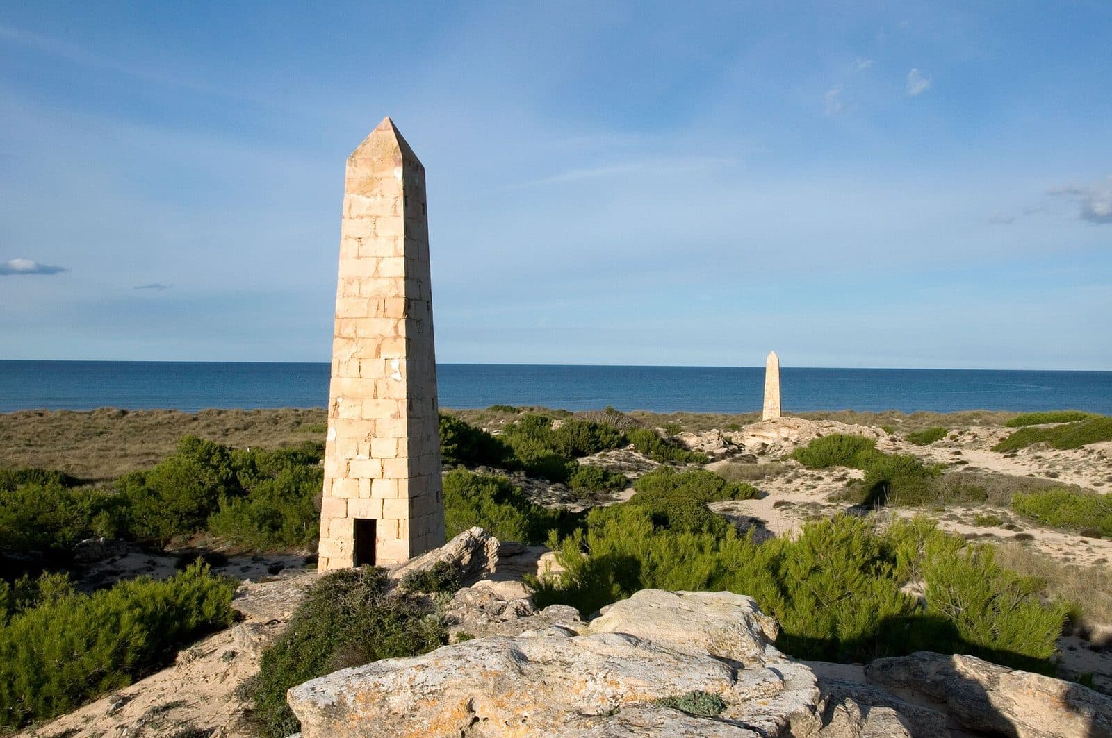

Between the coastal towns of the Bay of Alcúdia stand structures whose slender silhouettes resemble obelisks more than traditional Mallorcan towers. The Torre d'Enfilació near Urbanització Montfarrutx is one of these unusual relics. It was not a medieval watchtower but a highly visible alignment marker for the Spanish Navy. This distinction is precisely what makes the monument worth seeing: while castles and coastal watchtowers tell stories of attacks, pirates, and defense, the Torre d'Enfilació offers an insight into the technical military history of the past century. Its form is understood not through interiors or decoration, but through its location, its clear outline, and the imaginary line of sight to a second tower.
A visit is particularly suitable for travelers who enjoy interpreting inconspicuous traces of the island's history. The tower also makes a useful landmark for walkers and cyclists. On its own, it remains a specialized destination that may not justify a long journey; combined with Montfarrutx and the coastal landscape of the northeast, however, it becomes an illuminating excursion.
It is important to identify the site clearly: this article refers to the monument near Urbanització Montfarrutx. Around the bay, several former naval alignment towers bear the same Catalan generic name. Although they belonged to the same historical system, they are separate structures in different locations.
History and significance
A naval navigation aid
The name explains its purpose better than the English word “tower.” “Enfilació” refers to aligning several markers along a single line of sight. From the water, two towers positioned one behind the other were sighted so that their outlines appeared to overlap. This transit provided a fixed bearing. Together with additional bearings, it could be used to determine the position of a ship or submarine.
The Torre d'Enfilació near Montfarrutx was therefore part of a Spanish Navy navigation system. The structures were not intended to monitor the horizon or repel attackers. Their purpose was to remain unmistakably recognizable from a great distance. This explains their striking, highly simplified form and why the towers were conceived not individually, but as coordinated pairs.
The alignment towers of the Bay of Alcúdia
A total of 28 alignment towers were built around the Bay of Alcúdia, arranged in 14 pairs. The system extended from the Albufera de Muro to the Colònia de Sant Pere. The locations were chosen so that the Navy could establish fixed lines from different parts of the bay. A front tower stood closer to the sea, with a second tower around 200 meters behind it.
The towers were used for military exercises from 1941 to 1970. Spanish submarines used the markers during exercises involving mines and torpedoes, among other activities, when reliable position fixing within the bay was essential. Other accounts define the period of use more broadly as the years between around 1940 and the early 1970s. The historical essence is certain: the obelisks belonged to modern naval navigation, not to Mallorca's early modern coastal defenses.
From working instrument to monument
When their military use ended, the alignment towers lost their practical purpose. Some deteriorated, while other structures were demolished. Of the original 28 towers, 17 survived, and several examples along the bay were restored and repainted in their traditional colors.
Today, the Torre d'Enfilació near Montfarrutx illustrates a technique that required no digital displays: one unmistakably shaped marker on land, a second one behind it, and a trained eye on the water. The monument therefore preserves the memory not so much of a single event as of an entire working method. Anyone who understands its function sees not merely a narrow tower, but a historic line extending from the coast out into the bay.
What to see
The obelisk-like silhouette
The defining feature of the Torre d'Enfilació is its slender shape, tapering to a point at the top. Historical descriptions compare these alignment towers to obelisks. What mattered was an outline that stood out against the background and could be identified reliably even from a considerable distance.
This shape was designed to minimize the risk of confusion. The silhouette narrows toward its distinctive tip. Compared with Mallorca's stocky, usually round coastal watchtowers, the design appears notably technical and purpose-built. The structure communicates its function not through an inscription, but through geometry.
The historic color markings
The alignment towers around the bay were predominantly painted white. Red markings on their tips and a numbering system made it possible to distinguish the individual markers. Several surviving towers were later restored in this conspicuous white-and-red color scheme, while others now show natural stone or signs of deterioration.
When viewing the Torre near Montfarrutx, this historic use of color is more than a decorative detail. White and red increased visibility and helped observers identify the correct alignment marker. Color, number, and form together created an analog guidance system. In a sense, the tower was a fixed instrument whose display was located not inside it, but on its exterior surface.
The principle of the tower pair
A single alignment tower tells only half the story. The Torres d'Enfilació were arranged in pairs: one marker at the front and another farther inland on the same axis. From the correct point on the water, the rear tower appeared to move directly behind the front one. When both outlines overlapped, the vessel was on the predetermined bearing line.
This concept changes how the monument should be viewed. Rather than looking only at the tip, it is worth following the possible axis between the coast and the hinterland. The original construction depended precisely on this open line. Functionally, the surrounding space was just as much a part of the system as the masonry itself.
A tool without machinery
The structure's special quality lies in its simplicity. Its effectiveness emerged only through the interaction of location, perspective, and a second fixed point. Two stationary structures created a directional reference; several directions made it possible to determine a position through cross-bearing.
This is easy to visualize at the site: even a slight change in viewpoint shifts nearby and distant objects in relation to one another. The Navy systematically exploited this everyday observation. The Torre d'Enfilació is therefore not only a military relic but also a clear monument to analog navigation.
Not a medieval defensive tower
It is easy to confuse the structure with historic watchtowers, especially because both types of building occur along Mallorca's coasts. Their forms and purposes, however, are fundamentally different. A defensive or observation tower was designed for people, equipment, and extended stays. The slender alignment marker primarily needed to be visible and define an unambiguous axis.
Understanding this distinction also reveals the historical distance between them: the Torre d'Enfilació belongs to the naval history of the past century. It does not represent pirate warnings or an early modern signaling network, but submarine exercises, position calculations, and the military use of the Bay of Alcúdia.
Visiting the tower
First the form, then the line
The Torre d'Enfilació is best understood in two stages. First, its unusual silhouette catches the eye: narrow, soaring, and clearly different from the island's traditional coastal structures. Then it is worth shifting your gaze away from the tip and toward the surroundings. Only the imagined connection between the front and rear markers explains why the tower was built in this exact location.
An information panel or exhibition is not necessary for understanding it if you already know the principle: two fixed points are visually aligned; additional bearing lines produce a position. This simple idea turns a brief stop into a small lesson in historic navigation. Without that context, it is easy to come away with no more than the impression of an enigmatic obelisk.
Time required and nature of the visit
As an individual monument, the Torre does not require a long block of sightseeing time. It is more of a deliberate stop than a tour through rooms or collections. The amount of time worth allowing depends on whether you only view the structure or combine the visit with a walk through Montfarrutx and along the coast.
Visitors interested in architecture and technology should avoid moving on immediately. Different viewpoints reveal how strongly the overlap between foreground and background changes. This shift in perspective was the operating principle of the alignment system. For photography, therefore, not only a frontal view is interesting, but also an image that places the tower within its coastal landscape.
Check current times and access
No binding opening hours or confirmed admission details are recorded for the Torre d'Enfilació. It is therefore advisable to check the current situation before visiting, particularly if you expect a specific access route or a close-up inspection. The site's data module should serve as an initial guide. The tower is primarily interesting as a monument viewed from the outside; the true focus of the visit is its external form, location, and historic line of sight.
Getting there and parking
From Palma Airport
The stated route from Palma Airport to Urbanització Montfarrutx follows the Ma-30, then the Ma-13, and continues along the Ma-3400. The 64-kilometer road journey takes around 64 minutes. These details expressly cover the route only as far as Montfarrutx, not directly to the foot of the Torre d'Enfilació.
The Ma-30 initially leads away from the airport area, while the Ma-13 covers the longer section toward the north of the island. The Ma-3400 then leads into the northeast. For the final section within or on the edge of the development, the monument's exact location should be checked separately in your navigation system, as arriving in Montfarrutx does not automatically mean there is direct vehicle access to the tower.
From central Palma
From central Palma, the road distance to Urbanització Montfarrutx is 61 kilometers. The journey takes around 69 minutes and follows the Ma-13, Ma-3400, and Ma-3440. Here too, the stated time refers to the Montfarrutx destination area, not to a guaranteed parking space directly beside the monument.
Despite being slightly shorter, this route is estimated to take longer than the drive from the airport. Planning should therefore be based on the complete journey time, not on distance alone. Within the development, it is advisable to follow local traffic rules and park only where this is clearly permitted.
The final stretch
The Torre is a historic landmark, not a large visitor facility. It therefore makes sense to check the final turns on a map in advance and allow some flexibility for the transition from your vehicle to the monument.
For visitors arriving by public transport, the nearest stops are shown in the separate transport module. Since this does not confirm either a suitable walking route or its condition, the connection between the stop and the Torre should be checked on an up-to-date map before setting out.
Bus lines to Torre d'Enfilació at a glance
| Line | Route | Departures/day | First | Last |
|---|---|---|---|---|
| 324 | Can Picafort - Alcúdia | 339 | 00:07 | 23:55 |
| 302 | Can Picafort - Palma | 229 | 00:07 | 23:58 |
| 315 | Sa Pobla - Badia d'Alcúdia | 210 | 06:25 | 23:57 |
| A32 | Can Picafort - Aeroport | 86 | 00:33 | 23:43 |
| 316 | Son Serra - Inca | 84 | 06:36 | 22:39 |
| 325 | Alcúdia - Cala Rajada | 52 | 08:42 | 22:20 |
From the official GTFS feeds (TIB/SFM), no real-time data. The figures cover all stops in the town; weekend and holiday services differ — check with the operator before travelling.
Getting there by bus
Can Picafort sud 1 (55037) · 1.3 km as the crow flies
- 302Can Picafort - Palma · Daily
- 315Sa Pobla - Badia d'Alcúdia · Daily
- 316Son Serra - Inca · Daily
- 324Can Picafort - Alcúdia · Daily
- 325Alcúdia - Cala Rajada · Daily
- A32Can Picafort - Aeroport · Daily
Can Picafort sud 2 (55038) · 1.3 km as the crow flies
- 302Can Picafort - Palma · Daily
- 315Sa Pobla - Badia d'Alcúdia · Daily
- 316Son Serra - Inca · Daily
- 324Can Picafort - Alcúdia · Daily
Can Picafort centre 2 (55036) · 1.6 km as the crow flies
- 302Can Picafort - Palma · Daily
- 315Sa Pobla - Badia d'Alcúdia · Daily
- 316Son Serra - Inca · Daily
- 324Can Picafort - Alcúdia · Daily
- 325Alcúdia - Cala Rajada · Daily
- A32Can Picafort - Aeroport · Daily
Can Picafort centre 1 (55017) · 1.6 km as the crow flies
- 302Can Picafort - Palma · Daily
- 315Sa Pobla - Badia d'Alcúdia · Daily
- 316Son Serra - Inca · Daily
- 324Can Picafort - Alcúdia · Daily
- 325Alcúdia - Cala Rajada · Daily
- A32Can Picafort - Aeroport · Daily
Platja de Can Picafort 1 (55034) · 2.2 km as the crow flies
- 302Can Picafort - Palma · Daily
- 315Sa Pobla - Badia d'Alcúdia · Daily
- 316Son Serra - Inca · Daily
- 324Can Picafort - Alcúdia · Daily
- 325Alcúdia - Cala Rajada · Daily
- A32Can Picafort - Aeroport · Daily
Timetable data: official GTFS feeds (TIB/EMT), no real-time — check with the operator before travelling.
Nearby
Urbanització Montfarrutx
Montfarrutx is the monument's immediate point of reference. The Torre does not stand here as an isolated museum piece, but as the remnant of a system that used the entire coastline as its working area. A short walk through the locality is a good addition to the visit. This experience fits surprisingly well with the tower's original function: visibility was never absolute, but always depended on the viewpoint and a predetermined line.
The Bay of Alcúdia
The broader historical setting is the Bay of Alcúdia. The 14 tower pairs with which the Navy established its bearing lines once stood between the Albufera de Muro and the Colònia de Sant Pere. The tower near Montfarrutx should therefore not be understood merely as a local, isolated monument. It was one component of an extensive network along the coast.
Visitors wishing to see more surviving alignment towers can find examples near Son Serra de Marina, on the public Son Real estate, and along the waterfront promenade in Can Picafort. Comparing them sharpens the eye for different states of preservation, surfaces, and locations. At the same time, each example remains a separate monument; the Torre near Montfarrutx must not be confused with towers of the same name in these places.
Colònia de Sant Pere and the northeast coast
Montfarrutx can easily be included in an excursion through the coastal area around the Colònia de Sant Pere. Instead of rushing through several sights, consider a thematic connection: the coastal landscape, settlement history, and traces of the former naval navigation system.
The contrast between the seemingly simple tower and the vast extent of its former operational area is particularly revealing. The system worked not through monumentality, but through long-range visibility. Only when looking across the coastal landscape does it become clear why the Spanish Navy had an entire series of distinctive land markers erected here.
The place it belongs to
Urbanització Montfarrutx in the place guidePractical information for your visit
What to expect
The Torre d'Enfilació is not a traditional observation tower. Its historical value lies in its external form, its position in the landscape, and the navigation principle behind its paired arrangement. Anyone familiar with these three points will gain considerably more from the stop than someone simply looking for an old coastal tower.
The term “military tower” can also be misleading. The structure was neither a bastion nor a shelter, but a passive marker used for naval exercises. The actual technology lay in the observations made by crews on the water: align the towers, determine a direction, and intersect it with another bearing.
Distance and preservation
Surviving alignment towers are in varying states of preservation. Some have been restored, while others show clear signs of aging. Walls, bases, and any barriers should therefore be respected. In any case, a good view of the silhouette does not require touching or climbing the structure.
For photographs, a little distance is actually helpful. At close range, the overall obelisk-like shape is lost, while from farther away the clear tip and its setting within the coastal landscape are easier to see. A viewpoint slightly to one side also demonstrates how quickly imagined bearing lines shift when the perspective changes.
Finding the correct site
Because several monuments around the bay bear the name Torre d'Enfilació, Montfarrutx should always be checked as the locality in map and navigation services. A search result near Muro, Can Picafort, Son Real, or Son Serra de Marina refers to a different tower. Their shared historical function makes these structures related, but not interchangeable.
It is also helpful to remember the basic concept of the system before visiting: 28 towers, 14 pairs, with one front marker and another around 200 meters behind it. These few key facts are enough to make the location comprehensible. A silent structure suddenly becomes part of a precisely planned network.
Respect instead of climbing
The monument is best understood through observation. Climbing it would neither provide an authentic insight into its former use nor is it necessary for understanding the structure. The towers were landmarks viewed from the water, not observation platforms for visitors.
Visitors with children can demonstrate the alignment effect by looking at two distant points from different positions. However, no firm conclusions about the site's accessibility or suitability for strollers can be drawn from this; the current condition of the route should therefore be checked on site or by consulting up-to-date map data.