
Necròpolis de Son Real – Mallorca’s Seaside Necropolis
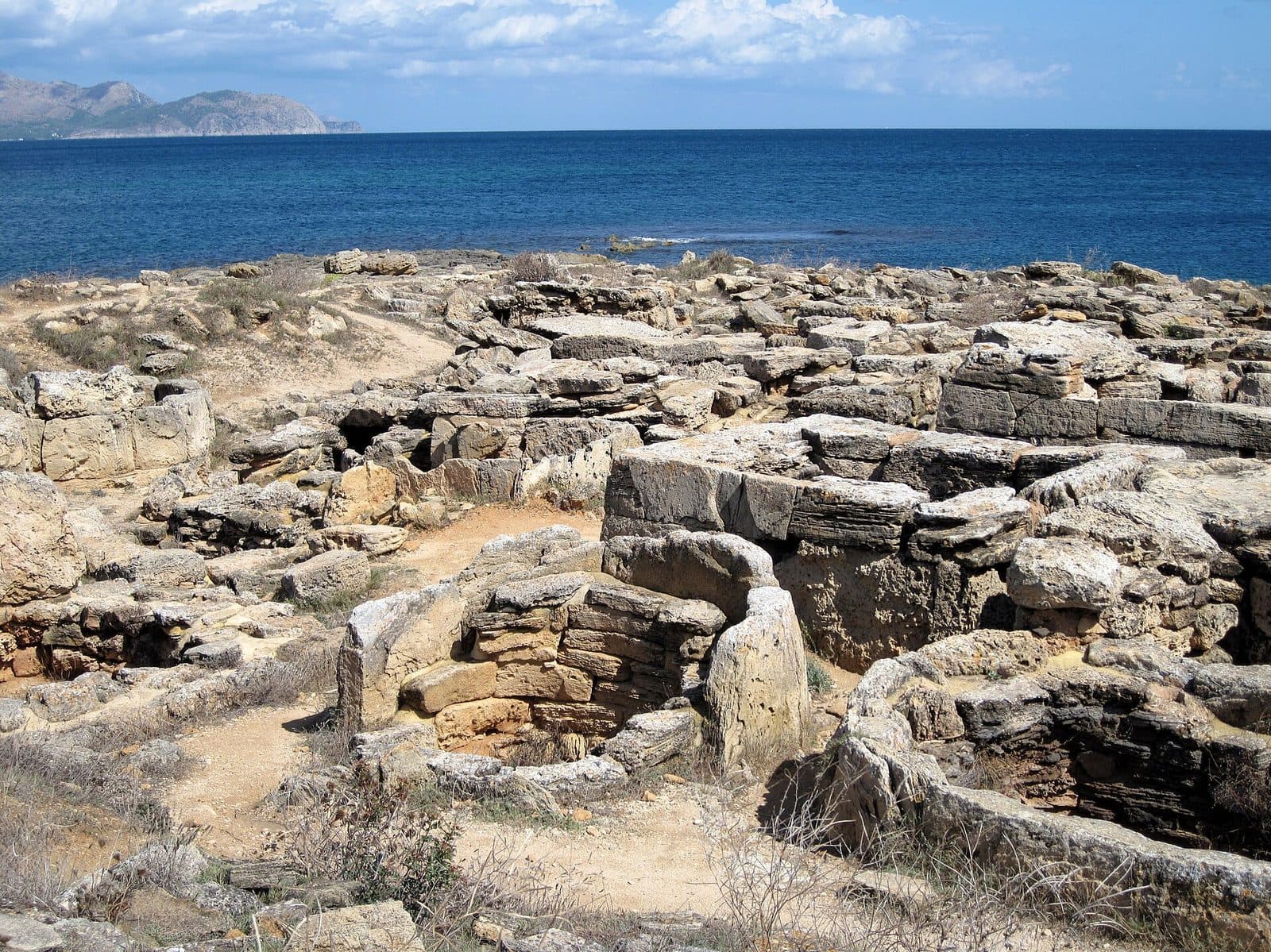

The Necròpolis de Son Real lies where you would hardly expect to find an important necropolis: directly on Mallorca’s northeast coast, amid flat rocks, dunes, and the sea. More than a hundred stone tombs form an unusual field of round, square, and rectangular ground plans. Some look like miniature talayots, while others recall the boat-shaped navetas of Balearic prehistory.
The coastal setting makes the visit especially impressive. The low structures are not displayed behind museum glass but remain in the landscape where they were used for many centuries. Only by walking slowly among the tombs does it become clear that the stones were not piled up at random. Their form, location, and size changed, as did the burial rituals.
The Necròpolis de Son Real is particularly worthwhile for travelers who want to understand archaeology through more than individual artifacts. Hikers and families can also easily combine the visit with a walk through the coastal landscape. However, do not expect a conventional museum with fully reconstructed rooms. This is an archaeological site whose impact comes from its original structures, their arrangement, and the open horizon.
The site forms part of a larger historic landscape in the Son Real area. The journey there is therefore already part of the experience, whether from Son Bauló along the coast or through the public estate with its marked routes. Anyone planning only a brief photo stop will underestimate the site. Its differences become apparent only when several tombs are compared with one another.
History and significance
The popular nickname “Cemetery of the Phoenicians” is memorable but historically misleading. The forms of the tombs instead point to indigenous Balearic building traditions. In particular, the replicas of talayots and navetas refer to the monumental architectural forms that shaped prehistoric Mallorca and Menorca. The name Punta dels Fenicis, by which the site is also known, should therefore not be understood as reliable evidence about its builders.
The first burials
The earliest burials date back to the 7th century BC, during the late Talayotic period. This was not a burial ground that casually developed around simple earthen graves. The dead were interred in carefully constructed stone buildings whose architecture reproduced familiar building forms on a smaller scale. Around 130 tombs and more than 400 burials have been documented across an area of approximately 1,000 square meters.
The elaborate tombs and valuables deposited within them are interpreted as evidence that members of local elites were buried here in particular. A tour of the site does not reveal from any single building exactly which settlement or community used the cemetery. However, traces of settlements from the relevant periods are known in the wider Son Real landscape. The necropolis was therefore not an isolated outpost but part of an inhabited and actively used coastal region.
Changes in burial rituals
Practices surrounding the dead did not remain unchanged over the site’s long period of use. Most tombs contained inhumation burials. Cremations were also introduced during a later phase. The architecture changed as well: alongside the striking round and square monuments, more modest rectangular tombs appeared, concentrated particularly in the southeastern area. The site remained in use until the 1st century BC.
The grave goods included objects made of metal, bone, glass, and ceramics. Weapons and possible musical instruments were also found. Food remains are associated with funeral feasts or other ritual acts. Son Real therefore appears to have been more than simply a place of burial. The ceremonies may also have served the living by strengthening the community and keeping its relationship with its ancestors visible.
Excavation and protection today
Large parts of the known burial ground were archaeologically investigated mainly in the middle of the 20th century. Other areas of the historic landscape remain unexcavated. Today, the site is preserved as an archaeological monument. Its significance extends beyond Mallorca, as such a dense group of monumentally designed Iron Age tombs is unusual in the western Mediterranean.
At this location, however, the coast plays more than a picturesque role. Wind, salt, and surf act directly upon the site. Its present appearance therefore reflects both thousands of years of preservation and continuing change. What looks like a robust field of stone is a fragile archaeological archive.
What to see
The first impression is surprisingly austere: low walls, pale stones, and open burial chambers on rocky ground. After only a few steps, however, the seemingly uniform field resolves into different types of structures. This is the key to visiting the site. The Necròpolis de Son Real has no single main monument; it tells its story through the differences between its tombs.
Talayot-shaped tombs
Some of the monuments have a round or square ground plan and resemble miniature talayots. These massive tower structures are among the defining forms of Mallorca’s prehistory. At Son Real, their external shape was adapted to the scale of a tomb. The result was not decorative miniature architecture but a stone symbol connecting the deceased with a familiar and evidently meaningful building form.
When viewing them, it is worth looking beyond the chambers themselves. The exterior outlines, carefully laid walls, and transition from the structure to the rocky ground are equally revealing. The different profiles can often be seen more clearly from a low viewing angle than from directly above.
Naveta-shaped tombs
Other structures reproduce the form of navetas. These tombs appear longer than the talayot-shaped structures and have a distinctly directional outline. Both types translate large-scale architecture familiar from the world of the living into smaller monuments for the dead.
The name “Cemetery of the Phoenicians” loses its apparent plausibility here at the latest. Anyone who compares talayot and naveta forms side by side will recognize how deeply they are rooted in the independent building traditions of the Balearic Islands. This is easier to grasp at the site than from any abstract historical timeline.
Rectangular tombs in the southeast
The picture changes in the southeastern section. Simpler tombs with rectangular ground plans are concentrated there and attributed to a later period of use. They appear less monumental than the older replicas of talayots and navetas. This contrast is precisely what makes them important: the necropolis was not a cemetery constructed all at once but was reused and altered over generations.
Anyone crossing the site too quickly can easily mistake the smaller rectangles for insignificant wall remains. In fact, they document changes in architecture and burial practices. A good tour therefore does not end at the most conspicuous round structures but deliberately includes this more understated sector.
Burial chambers and burials
The chambers that are open today reveal their original function but show only part of their historic condition. The dead were laid to rest here; more than 400 burials have been documented in total. Inhumation was predominant, while cremated remains also appeared in later phases.
The burial ground is not an exhibition of weapons, jewelry, and vessels. Its visible exhibits are the architecture itself: wall shells, chambers, entrances, and ground plans. Anyone wishing to learn more about the grave goods and their archaeological interpretation can combine the excursion with the information and museum area of the public Finca Son Real.
Punta dels Fenicis and the sea
The narrow coastal zone is an essential part of the overall scene. The view of the water remains open between the tombs, while dunes, scrubland, pines, and juniper groves extend behind them. As a result, the monuments do not appear to be museum objects relocated here but elements of a deliberately chosen landscape.
Off the coast lies the Illa des Porros, which has another burial site understood as a continuation of the archaeological complex. Viewed from the mainland, the island helps convey the greater extent of this landscape of the dead. However, it should not be confused with the main burial ground.
Visiting the site
The necropolis can be reached from Son Bauló by a coastal path. This changes how the site is perceived. After the coastal trail, dunes, or woodland, the burial ground appears without any monumental entrance structure. Only at close range do the regular ground plans become visible between the natural rock slabs.
Walking around the burial ground
A slow loop through the site is recommended. First, the striking round and square tombs provide an overview of the monumental forms. These should be followed by the elongated naveta-shaped structures and finally the simpler rectangular tombs in the southeast. Approached this way, a collection of ruins becomes a readable chronological development.
Viewing the burial ground itself takes considerably less time than an excursion through the entire Finca. The actual duration therefore depends mainly on the chosen access route. Anyone walking along the coast from Son Bauló or including the museum area and additional trails on the public estate should not squeeze the visit between two brief itinerary items.
Prepare instead of making a spontaneous short stop
Current opening and access conditions, as well as any admission arrangements, should be checked before traveling. This is particularly important if the visit is to include the Finca’s information center or museum, as these facilities may have their own access conditions.
Do not expect a staged visitor attraction at the burial ground itself. There are neither reconstructed burial scenes nor a sequence of fully furnished interiors. The quality of the visit depends on comparing forms, considering the surroundings, and respectfully treating the site as a historic cemetery.
Getting there and parking
The driving routes listed for reaching the area end in Urbanització Montfarrutx. The Necròpolis de Son Real itself lies outside the built-up area on the coast and is reached on foot for the final section.
From Palma and the airport
From Palma Airport, the drive follows the Ma-30, Ma-13, and Ma-3400 to Urbanització Montfarrutx. The route covers 64 road kilometers and takes around 64 minutes. From central Palma, the distance is 61 road kilometers; the journey via the Ma-13, Ma-3400, and Ma-3440 takes around 69 minutes. Both figures apply only as far as Urbanització Montfarrutx, not to the archaeological burial ground itself.
Before setting out, you should therefore check not only the destination for the drive but also the subsequent walking route.
Access via Son Bauló
Son Bauló is the most convenient starting point on the Can Picafort side. From there, the necropolis can be reached along a coastal path. This route combines the sea, sections of beach, and archaeology particularly directly. The Son Bauló bus stop also provides a way to reach the beginning of the walking route by public transport.
The walk is part of the excursion.
Access via Finca Son Real
A second option leads through the public Finca Son Real on the road between Can Picafort and Artà. There is a visitor parking area and marked trails leading through the estate toward the coast. This route reveals the scenic and historical connections between the estate, settlement remains, and necropolis.
Anyone wishing to combine the museum, manor buildings, and burial ground should choose the Finca route.
Bus lines to Necròpolis de Son Real at a glance
| Line | Route | Departures/day | First | Last |
|---|---|---|---|---|
| 324 | Can Picafort - Alcúdia | 152 | 00:04 | 23:52 |
| 302 | Can Picafort - Palma | 91 | 00:05 | 23:35 |
| 316 | Son Serra - Inca | 64 | 06:35 | 22:40 |
| 315 | Sa Pobla - Badia d'Alcúdia | 42 | 06:30 | 23:50 |
| A32 | Can Picafort - Aeroport | 42 | 00:35 | 23:45 |
| 325 | Alcúdia - Cala Rajada | 26 | 08:50 | 22:15 |
From the official GTFS feeds (TIB/SFM), no real-time data. The figures cover all stops in the town; weekend and holiday services differ — check with the operator before travelling.
Getting there by bus
Son Bauló (55043) · 1.9 km as the crow flies
- 302Can Picafort - Palma · Daily
- 315Sa Pobla - Badia d'Alcúdia · Daily
- 316Son Serra - Inca · Daily
- 324Can Picafort - Alcúdia · Daily
- 325Alcúdia - Cala Rajada · Daily
- A32Can Picafort - Aeroport · Daily
Timetable data: official GTFS feeds (TIB/EMT), no real-time — check with the operator before travelling.
Nearby attractions
Cafés, accommodation, and beach facilities are left behind as soon as the path heads east. The necropolis can therefore easily be included in an excursion that deliberately alternates between a holiday resort and an undeveloped landscape.
Son Bauló and Can Picafort
Son Bauló is convenient for access from the west and makes a good starting point for a coastal walk. Anyone staying in Can Picafort can combine the archaeological visit with a longer walk beside the sea without first having to drive inland. Enough time should be allowed for the return, as the same natural coastal landscape must be crossed again.
The beaches near Son Bauló and Can Picafort are a good addition to the excursion, but they should not be used as a reason to treat the burial ground as a shortcut or picnic area. Archaeological walls and burial chambers are not seats. It is better to keep beach breaks and the site visit physically separate.
Finca Pública de Son Real
The public Finca adds a second perspective to the visit. Its historic agricultural buildings contain an interpretation center and an archaeological museum area. The exhibition places the finds, rural life, and the estate’s history in context. This complements the tomb architecture visible at the archaeological site.
Marked trails lead through varied landscapes of dunes, scrubland, pines, and juniper. Anyone reaching the necropolis through the Finca will experience it not as an isolated ruin but as part of a cultural landscape used over a long period. The medieval manor buildings, courtyard, chapel, and agricultural structures also reveal how many historic layers Son Real has preserved.
Illa des Porros and Son Serra de Marina
The Illa des Porros lies in front of the burial ground and also contains documented burials. It belongs to the archaeological context but is not an easily accessible part of the walking tour. The most sensible viewpoint remains the coast by the necropolis.
The coastal landscape continues eastward toward Son Serra de Marina. Anyone planning a longer hike can include this section. For an excursion focused on cultural history, however, the combination of the necropolis, coastal path, and Finca Son Real is entirely sufficient.
The place it belongs to
Urbanització Montfarrutx in the place guidePractical visitor information
The tombs are low, and the terrain appears straightforward at first glance. In reality, rocky surfaces, sand, loose stones, and natural paths alternate. Especially on the coastal path, visitors should keep an eye not only on the sea but also on the ground.
Sun, wind, and water
The surf is not a backdrop for risky viewpoints: between the tombs and the sea, take care to maintain secure footing and a safe distance from the water’s edge.
Visiting with children
The Finca’s flat, marked trails and the clearly recognizable tomb forms make Son Real a suitable destination for families in principle. Children can compare round, square, and elongated ground plans or look for the differences between older monumental tombs and later rectangular ones. This makes the site easier to understand than lengthy abstract explanations would.
Close supervision is still essential. Open burial chambers, uneven rocks, and the nearby coast are not a playground.
Respecting the archaeological site
The fact that some walls are low and easy to touch does not make them any less worthy of protection. Food, breaks, and time at the beach belong in suitable areas outside the burial ground.
Expect a quiet original site rather than a spectacular reconstruction. Anyone arriving without preparation may see only low ruins. Those who know the building types and pay attention to the transition from round or square monuments to simple rectangles can read several centuries of burial history within the same site.
Local insider tips
Look closely in the southeast
The simpler rectangular tombs in the southeastern section are easily overlooked beside the striking round structures. They reveal the necropolis’s later phase and make changes in burial culture visible.
Architecture in miniature
Do not look only inside the open chambers: from a short distance, you can compare the round, square, and elongated boat-shaped exterior outlines. Many tombs reproduce talayot and naveta forms on a smaller scale.
Coastal path from Son Bauló
The route from Son Bauló leads on foot through the coastal landscape. As a result, the burial ground appears not as an isolated attraction but in its original setting between rocks, dunes, and the sea.
Put the finds in context at the museum
At the burial ground, visitors primarily see walls and chambers. Anyone wishing to place weapons, ceramics, and other grave goods in context can combine the excursion with the archaeological museum area at Finca Son Real.
Read the island as part of the site
Look for the Illa des Porros from the coast. It contains another burial site considered a continuation of the complex. View the island only from the safety of the mainland and do not attempt a spontaneous crossing.