
Bec de Ferrutx – Viewpoint Over the Bay of Alcúdia
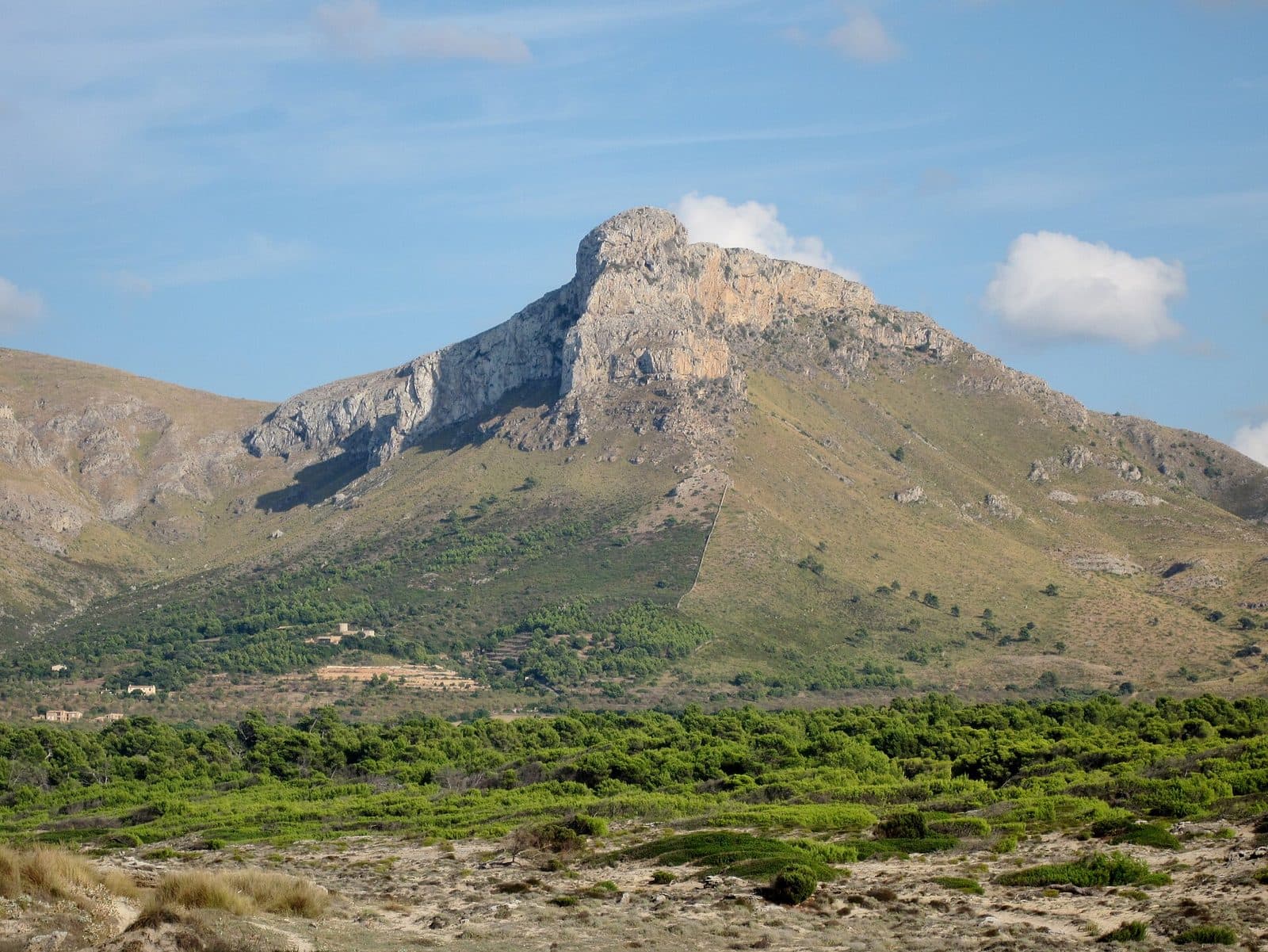

Like a stone tooth, Bec de Ferrutx rises above northeastern Mallorca. This viewpoint near Betlem is not an easily accessible photo stop but the destination of a genuine mountain hike. That is precisely what makes it appealing: the view across the Bay of Alcúdia does not open up beside the road, but only after a long walk through pines, diss grass, low shrubs, and increasingly rocky terrain.
Visitors experience a different side of the island here from the large viewing terraces of the Serra de Tramuntana. The mountains of Artà are lower, but they look exceptionally striking along the coast. On the way, the sea temporarily disappears behind the ridges of the Serra de Llevant, reappears between the slopes, and finally spreads out far below the rocky headland at Bec de Ferrutx.
The viewpoint is best suited to fit hikers looking for a quieter, more rugged coastal mountain. The final ascent is steep, rocky, and technically more demanding than the preceding sections of the trail. Sure-footedness, reasonable fitness, and confidence on loose ground are therefore more important than the mountain’s comparatively modest height.
Possible starting points include Betlem and Ermita de Betlem. From the development, the visit becomes a longer undertaking in which the historic path to the hermitage is already part of the experience. Those starting at the Ermita can instead focus on the mountain section leading to Bec de Ferrutx. In both cases, the viewpoint is the highlight of a hike and should not be regarded as a short walk.
What to See
The viewpoint is defined by the mountain’s natural form: a striking rocky headland on the edge of the Bay of Alcúdia. From a distance, the projecting rock resembles a huge tooth; up close, this distinct shape dissolves into edges, slabs, and stony mountain terrain.
The Bec de Ferrutx Rocky Headland
The Bec forms the impressive leading edge of the mountain massif. It is important to distinguish between the rocky spur visible from afar and the highest point: the characteristic spur lies slightly below the actual summit area. Route descriptions often refer to both collectively as Ferrutx, but on site it becomes clear that the photogenic rock projection and the highest elevation are not exactly the same point.
This shape is precisely what makes the viewpoint so unusual. From below, the final ascent looks almost intimidatingly steep. On the route, it proves manageable, but it demands full attention. The trail approaches the rock along a ridge; with every step, the ground becomes stonier while the vegetation recedes. The unobstructed view is directly connected to the openness of the terrain, as there is scarcely any shelter from woodland or tall bushes on the upper section.
The Bay of Alcúdia
The broad panorama extends north and west from Bec de Ferrutx. The Bay of Alcúdia sweeps along the coast in a wide arc, making the scale of the northeastern coastline particularly apparent from above. In good visibility, the view reaches the Formentor peninsula. The Serra de Tramuntana can also be seen on the horizon, its higher peaks appearing from this perspective like a distant mountain backdrop.
The location changes the familiar perception of the bay. From the beach it appears open and almost boundless; from Ferrutx, its shape becomes legible. The coastline, sea, and northern mountain ranges are all visible at once. The viewpoint is therefore worthwhile not only as a summit destination but also for anyone wishing to understand the spatial form of Mallorca’s landscape.
The view to the south is less dominant, although prominent elevations in the island’s interior can be identified in clear conditions. The bay remains the most impressive direction: there the mountain appears to drop toward the sea, while the projecting rocky spur gives the panorama its dramatic depth.
Coll d’en Pelat
Coll d’en Pelat is the decisive threshold before the final ascent. Up to this point, the route includes repeated climbs and descents but mostly follows a recognizable mountain trail. From the pass to Bec de Ferrutx, the route becomes steeper and substantially rockier. Loose stones and exposed bedrock now determine each step; the hike noticeably changes from a scenic trail into a summit ascent.
The pass is also a good place to assess your remaining strength honestly. Anyone who arrives already exhausted or feels uncomfortable on loose ground should not underestimate the final section. The return follows the same terrain downhill, and the shifting stones often require more concentration during the descent than on the way up.
Pine Forest and Diss Grass
Below the open summit area, the route passes through several landscapes typical of the Serra de Llevant. Pines line the trail at the beginning, with low scrub and extensive areas of diss grass growing between them. In places, the grass reaches high along the narrow path and can visually obscure the trail. Dwarf palms also appear among it, a characteristic plant of the Mediterranean coastal landscape.
The changing vegetation accounts for much of the route’s appeal. Shadier woodland sections are followed by open slopes; later, low vegetation, stones, and rock dominate the scenery. This is not a uniform summit hike. Instead, the different types of terrain create the impression of crossing several small landscapes in succession.
The Trail From Ermita de Betlem
The path to Ferrutx begins to the left of the entrance to Ermita de Betlem. At first, its course is not always easy to identify among the pines and vegetation. It then becomes clearer and leads through the mountains with several climbs and descents. The trail passes the area around Cases de Can Virell and continues toward Coll d’en Pelat.
Starting from Betlem adds another section. The route initially follows the old path to the hermitage, partly along a broader gravel track and later on a steeper mountain trail. On this version, the Ermita is not merely a starting point but a prominent intermediate stop. The hike is therefore clearly divided into the ascent from the coast to the hermitage and the subsequent mountain trail to Bec de Ferrutx.
Visiting Bec de Ferrutx
A visit begins with a decision: should Bec de Ferrutx be reached from Betlem as a long day hike, or should Ermita de Betlem serve as the starting point? Both options lead to the same viewpoint, but they differ significantly in length and character. Starting in Betlem adds the old hermit’s path; from the Ermita, the hike begins in the mountains.
Starting in Betlem
At the edge of the development, wooden posts point along the GR 222 toward Ermita de Betlem. A broader gravel path begins beyond a metal barrier. Shortly after the start, the route passes former military buildings. Part of the site is now used as a base for monitoring and fighting forest fires; nearby stand former stable buildings and the uninhabited Cases de Betlem.
After this easy beginning, the trail becomes more mountainous. It leads across Pas des Grau and Coll de s’Ermita to Font de s’Ermita and onward to the hermitage. This first section has its own scenic character and should not be viewed merely as an approach route. At the same time, it significantly lengthens the outing, as anyone continuing to Ferrutx must later cover the entire trail back to Betlem.
Starting at Ermita de Betlem
The shorter and more commonly described version starts directly at the hermitage. Even this is not a brief summit circuit. The round trip is described as approximately 11 kilometers with more than three hours of walking time alone; photography stops and a longer stay at the viewpoint must be added. Different route recordings show that the actual duration depends greatly on the chosen path, pace, and conditions.
The first section follows a narrow trail that is partly hidden by vegetation. Repeated climbs and descents then follow. The hike therefore does not gain elevation in a single, steady ascent. This takes energy, especially on the return, when previously completed counter-climbs have to be tackled again.
Final Ascent and Viewpoint Break
The most demanding section begins at Coll d’en Pelat. The trail becomes steeper, rockier, and covered with loose stones. The pace should slow considerably here. The viewpoint is not going anywhere, and hurried steps offer no advantage on this ground. Extra care is required in windy conditions because the exposed rocky headland provides scarcely any shelter.
A long break at the top is worthwhile because the panorama cannot be absorbed in a single photograph: first the eye falls across the Bay of Alcúdia, then follows the coastline toward Formentor and the distant Tramuntana. At the same time, the place chosen to stop should be selected carefully.
Crowds and When to Visit
The route is described as exceptionally quiet on weekdays; hikers sometimes encounter goats or sheep rather than larger groups. This does not guarantee solitude, and no fixed best time of day can be derived from the route either. Sufficient daylight, good visibility, and stable weather are what matter most. In hot conditions, the open sections and exposed summit ascent become strenuous. After rain, loose, rocky ground can be unpleasant; strong wind makes the final exposed area less comfortable in particular.
Current access conditions should be checked before setting out. No reliable opening hours or admission details are recorded for the viewpoint. As it is a hiking destination in the open landscape, planning should focus primarily on the route, weather, daylight, and any local notices.
Getting There and Parking
Navigation directions initially lead to Betlem on the northeastern coast. The drivable road approach ends there; Bec de Ferrutx itself is then reached on foot. This is important when planning your time because the driving time to Betlem says nothing about the duration of the mountain hike.
From Palma Airport
The road distance from Palma Airport to Betlem is 73 kilometers. The drive takes around 65 minutes via the Ma-15, followed by the Ma-3322 and the Ma-3331. These details apply expressly only as far as Betlem. From there, the longer hiking route begins along the old path to Ermita de Betlem and onward to the viewpoint.
The route crosses the eastern part of the island before approaching the coast. For a visit immediately after landing, sufficient extra time should therefore be allowed for orientation, preparation, and the long hike in addition to the drive itself. Bec de Ferrutx is not a destination that can reasonably be squeezed into a short spare hour.
From Central Palma
From central Palma, the road distance to Betlem is 75 kilometers. The drive takes around 71 minutes and also follows the Ma-15, Ma-3322, and Ma-3331. Once again, the mileage and driving time apply only as far as Betlem. The subsequent route to the viewpoint is a mountain hike with substantial elevation changes and a demanding final ascent.
Anyone wishing to begin at Ermita de Betlem cannot simply continue driving to the summit. The access road to the hermitage is described as very narrow and winding and is also popular with cyclists. Slow, attentive driving is particularly important there.
Parking and Bus Travel
For the route from Betlem, parking is available at the starting point in the development. At Ermita de Betlem, there is a small parking area immediately beside the entrance to the hermitage. Its limited size means that a free space should not be assumed to be available at all times.
Betlem has bus stops, but public transport does not take visitors to Bec de Ferrutx. From the stop, the entire walking route remains: through the development, along the old hermit’s path, and onward into the mountains. Sufficient extra time must be allowed for the return journey because walking times over rocky terrain can vary more than on an ordinary walking path.
Bus lines to Bec de Ferrutx at a glance
| Line | Route | Departures/day | First | Last |
|---|---|---|---|---|
| 421 | Colònia de Sant Pere - Artà | 24 | 07:33 | 19:52 |
From the official GTFS feeds (TIB/SFM), no real-time data. The figures cover all stops in the town; weekend and holiday services differ — check with the operator before travelling.
Getting there by bus
Montferrutx 1 (6004) · 2.0 km as the crow flies
- 421Colònia de Sant Pere - Artà · Daily
Montferrutx 2 (6009) · 2.0 km as the crow flies
- 421Colònia de Sant Pere - Artà · Daily
Timetable data: official GTFS feeds (TIB/EMT), no real-time — check with the operator before travelling.
Nearby Places
Between the sea and the mountains of Artà, Betlem forms a narrow transition zone. The rocky northeastern coast begins on one side, while the Serra de Llevant rises on the other. Bec de Ferrutx should therefore not be viewed in isolation: even the approach connects a coastal settlement, traditional paths, and the quiet mountain landscape above the village.
Betlem
Betlem is a peaceful starting point for hikes along the coast and toward the Ermita. Anyone who still has energy after descending can experience the contrast in landscapes particularly directly: rock, wind, and views across the bay define the day above, while low coastal vegetation and the sea return below.
Any combination should nevertheless be planned realistically. The long Ferrutx route already takes up a large part of the day. A brief stop by the water is more suitable than another extensive hike. Nearby coastal destinations include Cala na Clara and Cala des Camps; both belong to the area around Betlem but should not be underestimated as mere add-ons to a strenuous mountain tour.
Ermita de Betlem
Ermita de Betlem is the natural cultural reference point for the hike. From Betlem, it becomes an intermediate stop; on the shorter mountain route, it is the starting point. Its position above the coast also explains why the trail to Ferrutx offers expansive views even before the actual summit ascent.
Anyone who does not wish to complete the full route to Bec de Ferrutx can choose the hermitage as a destination in its own right. This is particularly useful for groups whose fitness or sure-footedness varies. The path to the Ermita and the onward trail to Ferrutx are two clearly distinct sections; nobody should feel pressured into tackling the more technical final ascent simply because of the distance already covered.
Colònia de Sant Pere and Artà
Colònia de Sant Pere is a good place to switch from the mountains to the coast after the hike. The village lies on the edge of the Bay of Alcúdia and offers another perspective from sea level on the mountain ranges around Betlem. Artà, by contrast, is the main hub in the hinterland and the starting point for the winding approach to the Ermita.
Both places are better suited to a relaxed conclusion than to additional activities on a tight schedule. After several hours on rocky terrain, a flexible break generally makes more sense than a densely packed sightseeing itinerary.
The place it belongs to
Betlem in the place guidePractical Information for Your Visit
During the first kilometers, Ferrutx can appear easier than it really is. Broader trails and woodland sections characterize the beginning of the route from Betlem; the path from the Ermita also starts comparatively moderately. Its character changes at Coll d’en Pelat, however, because that is where the hike reveals its most demanding section.
Footwear and Equipment
Sturdy hiking boots with grippy soles are the right choice for the steep, rocky final ascent. Loose stones can shift underfoot on the way up and become even more troublesome during the descent. Smooth-soled casual shoes are unsuitable for both the terrain and the length of the hike.
Water and food belong in your backpack because you should not rely on finding supplies along the mountain trail. A jacket is useful even on pleasant days, as Bec de Ferrutx can be windy. At the same time, the open landscape makes sun protection essential: there are no long shaded stretches in the higher sections, and the diss grass offers no protection from the sun.
A prepared map or offline navigation is helpful. At first, the path is difficult to recognize in places and can become indistinct among pines, grass, and low vegetation. Trail markers there are no substitute for navigating independently. Branches leading toward private land should not be used as supposed shortcuts.
Visiting With Children
The hike is described as strenuous because of its length, numerous climbs and descents, and rocky final ascent. It is therefore not very suitable for children without experience on longer mountain hikes. The key consideration is not simply whether they can manage the ascent: the return over loose ground and several counter-climbs must also be completed safely.
Older children accustomed to mountain hiking can tackle the route with careful preparation if they genuinely have the required fitness and sure-footedness. Adults should remain especially attentive at the exposed viewpoint.
Sun, Wind, and Ground Conditions
The vegetation changes, but open terrain dominates the upper area. This can substantially increase the physical strain in warm weather. On windy days, the rocky headland is much more exposed than the woodland below. The weather and visibility should therefore be checked before the drive, not only after reaching the parking area.
After rainfall, additional care is needed on rock and loose stones. Even in dry conditions, the descent requires controlled foot placement.
What Not to Expect
Bec de Ferrutx is the destination of a mountain hike. The visit itself consists of the journey, the changing landscapes, and time spent on natural mountain terrain. Nor should the mountain’s height lead to a false assessment. The Serra de Llevant does not reach the elevations of the Tramuntana, but the length of the route, repeated counter-climbs, difficult-to-follow path, and rocky final section make Ferrutx a serious hike. Those seeking exactly that are rewarded at the end with sweeping views across one of the most distinctive coastal landscapes of northeastern Mallorca.
Local insider tips
Make an Honest Decision at the Coll
The steepest and rockiest section begins at Coll d’en Pelat. Anyone who is already tired there or feels uncertain on loose ground should turn back—the same route must later be negotiated downhill.
Distinguish the Rocky Spur From the Summit
The tooth-like rocky spur visible from afar is not exactly the highest point. For photographs, it is worth focusing on the shape of the Bec itself rather than heading exclusively for the highest elevation.
Take Time to Read the Panorama
At the top, do not look only straight across the bay: in good visibility, the panorama reaches Formentor and the Serra de Tramuntana. The broad arc of the Bay of Alcúdia becomes fully apparent only when you change your viewpoint.
Look Out for Dwarf Palms
Dwarf palms grow among the pines, diss grass, and low scrub. They are among the characteristic plants of these coastal mountains and are easily overlooked when attention remains fixed only on the summit and the trail.
Choose a Weekday Over the Weekend
The route is described as particularly quiet on weekdays. Anyone hoping to experience Ferrutx in greater peace should therefore plan a weekday visit—even though solitude can never be guaranteed on a freely accessible hiking trail.