
canó del Moro near Port d’Alcúdia
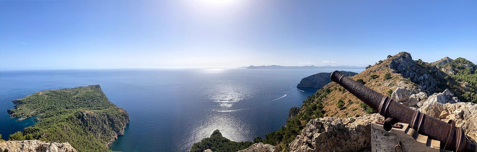

The canó del Moro is one of those historic places in northern Mallorca whose significance is not immediately apparent. The attraction is not on the waterfront promenade of Port d’Alcúdia but in the rugged defensive terrain of Penya Roja on the peninsula of La Victòria and Cap Pinar. The approach itself makes it clear why this location was once chosen to defend the coast.
The focus is less on a single, easily accessible monument than on a historic defensive site whose impact comes from the interplay of rock, fortifications, and far-reaching views. An artificial passage leads through a point where the path above the precipice initially appears unable to continue. Beyond it lies the enclosed area of the former watch post.
A visit is particularly rewarding for people who enjoy reading history in the landscape. The rugged location explains the military logic better than an information board: From the heights, the view extends far across the coast, the sea, and northern Mallorca. At the same time, the route makes clear how difficult it must have been to bring a cannon up to this position.
History and significance
The defining historical source at this site is its location. Penya Roja rises above the coast of Alcúdia on the peninsula of La Victòria and Cap Pinar. Anyone who reaches the fortified area immediately understands why the elevation was suitable as a watch and defensive position: The sea and large parts of the surrounding land can be surveyed from here, while access is severely restricted by the rocky terrain.
The watch post at Penya Roja
The Atalaya of Penya Roja formed part of a position designed for observation and defense. Its protection did not rely on constructed masonry alone, as the rock itself provided a substantial part of the defenses. Steep slopes and a difficult approach turned the site into a natural fortress that required structural reinforcement in only a few places.
This is precisely what distinguishes the complex from an urban castle with large gates, courtyards, and complete rings of walls. At Penya Roja, the landscape was not displaced but used for military purposes. The fortifications follow the terrain and reinforce its natural obstacles. Historical descriptions compare this principle with rock-integrated defensive structures and the so-called Bastidas: What mattered was not monumental size but control of a difficult-to-reach location.
The canó del Moro
The name places the cannon at the center of attention. A traditional saying about Penya Roja alludes to how difficult it must have been to carry the cannon up and later bring it back down. Even without an elaborate legend, the true feat becomes apparent: A route that already demands care on foot had to be negotiated with heavy military equipment.
The cannon is therefore more than an isolated historical object. It points to the practical side of coastal defense and to the effort involved in moving the cannon up and down. The canó del Moro thus recalls both this transport and its actual defensive function.
A historic site in the landscape
Today, the significance of the site is best understood while walking. The distance from the harbor, the demanding ascent, and the controlled passage into the fortified area together form a historical narrative. The site does not feel like a self-contained museum but like a preserved piece of defensive landscape where topography and structure can only be understood together.
The panoramic view gives this history its scale. From Penya Roja, the view extends across sea and land; the position therefore appears not as an isolated outpost but as a deliberately chosen observation point. Anything that might have remained hidden down on the coast could be detected early from up here.
What to see
Shortly before the fortified area, the path appears to end at the rock. Natural stone rises on one side, while the terrain drops away steeply on the other. It is precisely at this bottleneck that the complex’s most important structural intervention becomes visible: An artificially created crossing leads through or over the rock, making access to the position possible in the first place.
The covered rock passage
The entrance takes the form of a small tunnel or covered passage. It makes use of the natural rock and supplements it only where a defensible passageway was required. The result is not a ceremonial gate but a narrow, functional passage. The route is channeled through it; anyone wishing to reach the position must pass through this controllable point.
This passage is the clearest architectural feature of the canó del Moro. It shows how sparingly the builders could use structural elements when the landscape already provided protection. Rock and construction cannot be neatly separated here, as the artificial section bridges a point that otherwise appears impassable.
Passing through it changes the perception of the site. Before the passage, the exposed approach dominates; beyond it lies the sheltered microcosm of the watch post. This clear sequence made military sense and remains legible today: approach, bottleneck, fortified interior.
The fortified area
Beyond the entrance lies the actual terrain of the Atalaya de la Penya Roja. It does not have the regular shape of a large fortress; instead, its form is determined by the mountaintop and its natural boundaries. In many places, the inaccessibility of the rock replaced massive artificial barriers.
Anyone looking for halls, decorated interiors, or a conventional castle complex will therefore misinterpret the site. Its reduction is precisely what makes it worth seeing: Its architecture is explained through sightlines, terrain edges, and its single controlled entrance.
The cannon position
The canó del Moro belongs within this military context. Its position on the heights makes sense because of the unobstructed view over the surrounding area. The historical appeal therefore lies not only in the cannon itself but also in the question of how it reached this difficult-to-access location.
The arduous transport becomes almost physically tangible during the ascent. Narrow, rocky passages that already demand care from individual hikers had to be negotiated with heavy equipment. The route illustrates how strongly access is shaped by the terrain.
The panoramic view from Penya Roja
Above the fortified position, a panoramic view opens across northern Mallorca and the Mediterranean. The vista is not an incidental addition but the heart of the complex. Observation took place from up here; coastlines, sea routes, and approaches to the land could be monitored from a great distance.
The view also helps place Port d’Alcúdia in context. Today’s harbor, with fishing, recreational boats, and trade, lies in a bay that has long been used as a maritime gateway. From Penya Roja, this coastal area appears as a connected whole. The historic watch post thus becomes more understandable than it would be by viewing the cannon alone.
Visiting canó del Moro
A visit does not begin at the canó del Moro itself but with the approach through the terrain of the peninsula of La Victòria and Cap Pinar. The route is an essential part of the experience. With every gain in elevation, the modern harbor recedes while the rock, coast, and strategic views come increasingly to the fore.
The ascent
The historical source describes the approach as demanding and, at one point, almost improbable: Before the artificial rock passage, it appears as though the path cannot continue above the precipice. This is not merely an incidental section of the route but the dramatic transition into the fortified area. Walking calmly and paying attention to the ground are more important here than speed.
No reliable general visit duration can be given for the canó del Moro. The time required depends largely on the starting point, walking pace, and breaks taken during the ascent. Anyone planning the site as no more than a quick photo stop underestimates its character. To understand its historical context, allow enough time to examine the rock passage, the position, and the sightlines separately.
Inside the position
Beyond the bottleneck, the terrain is best explored without rushing. First, it is worth looking back at the entrance, as the view from inside makes it particularly clear how easily this point could be controlled. The position of the cannon in relation to the coast can then be considered. The unobstructed view explains why this difficult-to-reach height was of military interest.
The canó del Moro is primarily a historic site in open terrain. Understanding comes from observing the structure and its surroundings. Anyone looking only for a large standalone monument will overlook the most important element: the landscape as part of the fortification.
Planning and current conditions
No fixed opening hours or admission price are recorded. Current accessibility and any local regulations should therefore be checked before setting out. This is especially important at a remote historic site, as access conditions can change independently of regular museum operations.
There is also no reliably documented time of day when visitor numbers are lower. Rather than relying on a supposed secret time, it makes more sense to plan around visibility, weather, and safe trail conditions. The panoramic view is a central part of the visit, so poor visibility takes away more than just an attractive photo opportunity.
Getting there and parking
The listed road routes initially lead to Port d’Alcúdia. However, the canó del Moro is not in the center of the harbor town but farther out in the Penya Roja area on the peninsula of La Victòria and Cap Pinar. The driving directions should therefore not be understood as taking you directly to the cannon. The road journey is followed by a further approach to the historic terrain and finally an ascent on foot.
From Palma Airport
The road distance from Palma Airport to Port d’Alcúdia is 60 kilometers. The journey takes around 47 minutes and follows the Ma-30, then the Ma-13, and finally the Ma-3460. This travel time ends in Port d’Alcúdia, not at the canó del Moro. Additional time must be allowed for the final section toward the peninsula and for the walk.
The Ma-13 forms the largest part of the route north. After arriving in the Alcúdia area, precise directions to the starting point of the ascent are required. As there is no reliable information about a dedicated parking area immediately nearby, check the local parking situation rather than assuming that you can drive directly to the attraction.
From central Palma
The road distance from central Palma to Port d’Alcúdia is 57 kilometers. The journey takes around 51 minutes via the Ma-13 and the Ma-3460. This information also refers specifically to the harbor town. The historic site is located outside the urban center in considerably more demanding terrain.
Anyone arriving by car should plan the drive and the walk as separate stages. The canó del Moro is not a monument where you can stop immediately outside the entrance. Its remote location and difficult approach are part of the site’s historical meaning.
By public transport
No bus stop is recorded in the immediate vicinity of the canó del Moro. Traveling to Port d’Alcúdia therefore does not replace planning for the final section. In particular, the route from the coastal plain to Penya Roja must be considered separately. Sufficient time should also be reserved for the return journey, as the fortified site is not part of a walk within the town.
Nearby attractions
After the rocky terrain of Penya Roja, Port d’Alcúdia feels like a deliberate contrast. Fishing, recreational boats, and trade come together on the waterfront. The harbor consists of distinctly different areas: the commercial port and the facilities for smaller vessels, with the fishing pier and marina. This makes it easy to combine a visit to the canó del Moro with a walk around the region’s maritime gateway.
Port d’Alcúdia
The history of the harbor reaches far back. Roman Pollentia already used the coastal access, although nothing remains of the harbor facilities from that period. Later documented harbor projects and modern expansion continued to shape the town. After the solitary watch post on Penya Roja, Port d’Alcúdia reveals the other side of the same coastal area: not observation and defense, but transport, supplies, and fishing.
The harbor also provides a natural conclusion to the excursion. From above, the coast appears as a strategic area; below, it is experienced as a lively place of work and recreation. Combining both perspectives provides a fuller picture of why the Bay of Alcúdia was important across different periods.
Alcúdia Old Town
Alcúdia Old Town is a good choice for further historical exploration. Its city wall, the preserved gates Porta del Moll and Porta de Sant Sebastià, and the fortified church of Sant Jaume demonstrate defensive architecture on an urban scale. The contrast with Penya Roja is revealing: There, the rock determines the structure; here, walls and gates form an enclosed city fortification.
The Roman theater of Pollentia can also be included in a history-focused day. However, it belongs to a different period and served a completely different function. The canó del Moro remains the place where later coastal defense and the military use of a difficult-to-access elevation can be understood most clearly.
Local insider tips
Look back at the passage
After passing through the covered rock passage, it is worth looking back. From the inside, it becomes particularly clear why the narrow passage was so easy to control and why the natural rock replaced a large part of the fortifications.
Study the terrain before the cannon
Do not focus only on the cannon straight away. First take in the coastline, terrain edges, and approach: Only within this context does it become clear why Penya Roja was chosen as a watch and defensive position.
Combine it with Alcúdia’s walls
Anyone wishing to compare two forms of defensive architecture can combine Penya Roja with Alcúdia Old Town. Above, the rock provides most of the protection; in the town, walls, gates, and the fortified church perform this role.