
Penya des Migdia – Viewpoint Over Northern Mallorca
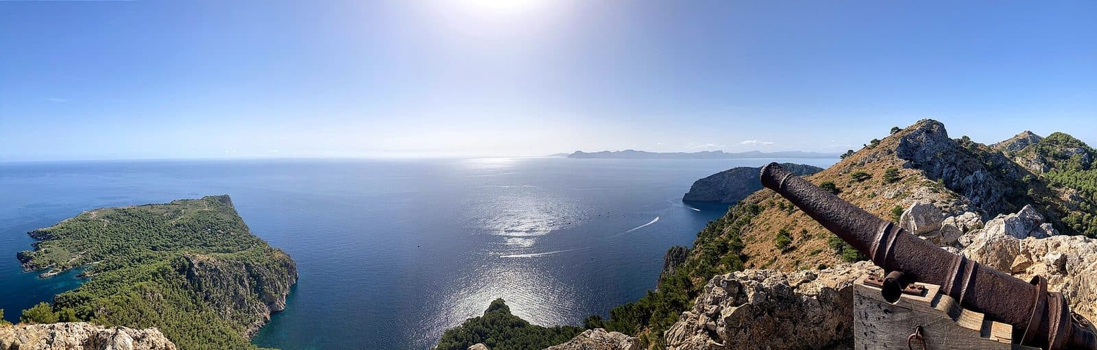

The narrow rock passage comes late in the hike. Until then, the route to Penya des Migdia sometimes feels like a short woodland walk above the Bay of Pollença. Then the limestone wall draws closer, the slope beside the trail drops steeply toward the sea, and the walk becomes a small mountain hike. At the top, bare rock, the remains of a fortification, and a single old cannon await.
The viewpoint lies on the La Victòria peninsula, which projects into the sea between the bays of Pollença and Alcúdia. This location explains the destination’s appeal: From the ridge summit at an elevation of 354 meters, northern Mallorca opens up in several directions. You can see the Bay of Pollença, the long Formentor peninsula, and the coastal landscape around Alcúdia. In clear conditions, the view extends beyond Cap des Pinar.
Penya des Migdia is also known as Penya Rotja. The climb is particularly worthwhile for sure-footed hikers looking for plenty of variety over a short distance: pine forest, a rocky mountain trail, exposed sections, traces of history, and a summit with views far more impressive than the route’s length might suggest. It is not, however, a destination for a casual detour in street shoes.
The key difference from many easily accessible miradores lies in the route itself. The view has to be earned on foot, and the final section requires concentration, a head for heights, and occasionally the use of your hands. This is precisely what makes the visit feel like a complete experience: The views do not begin only at the top but accompany the entire route along the steep northern coast.
History and Significance
A single cannon on a remote limestone summit initially seems almost mysterious. Together with the remains of a fortified building from the 17th century, however, it points to the former military importance of Penya des Migdia. Its commanding position above the sea and the approaches to Mallorca’s two large northern bays shaped the site’s former military role.
The Observation Post
The La Victòria peninsula separates the Bay of Pollença from the Bay of Alcúdia. Anyone stationed high above the coast here could survey a wide stretch of sea. Route descriptions refer to the building remains visible today as remnants of an old military post or watch station. Their exposed position illustrates their function better than any information panel: From here, an approach by sea could be spotted early.
What remains is instead a small, rugged outpost. That suits the topography. The rock itself provides part of the defense; the approach is narrow, steep, and exposed in several places. Anyone tackling the final section today experiences directly just how remote and difficult to reach this position must once have been.
The Cannon
The site’s history is embodied most vividly by the old cannon near the summit. It is the most striking relic and also the reason why the viewpoint is more than an anonymous rock above the sea. Its barrel almost automatically directs your gaze toward the coast and horizon. Even without a reconstructed emplacement, it is easy to understand why this particular location was chosen for coastal surveillance and defense.
Today, its significance has shifted completely. The military observation point has become a hiking destination. The once-strategic panoramic view is now the true reward for the ascent, while the cannon and wall remains serve as reminders that the island’s remote heights were not always seen merely as natural scenery.
What to See
The Penya des Migdia experience consists of a sequence of clearly distinct trail and viewpoint moments. A single summit photo therefore tells only half the story. Pine forest, sea views, the rock passage, building remains, and cannon all belong together; each section changes the character of the hike.
The Route From Ermita de la Victòria
The starting point is Ermita de la Victòria. The hiking trail begins behind the complex, initially heading toward Talaia d’Alcúdia. The first section follows a rocky path across the forested slope. Pines provide shade in places, while the Bay of Pollença is already visible between the trunks. The climb gains elevation quickly and is considerably steeper than the short overall distance might suggest.
After the first 800 meters, choosing the correct route becomes important. A turnoff leads onto a narrower path toward Penya des Migdia. In this area, one section is protected by a wooden railing. The vegetation becomes lower; esparto grass, mastic shrubs, and dwarf palms line the path. At the same time, the limestone becomes more prominent and the view across the sea grows increasingly open.
Ses Tres Creus
Ses Tres Creus is a distinctive landmark on the approach. The three crosses stand before the most challenging sections and already offer broad views across the coast. Anyone who finds the wind, steep ground, or exposed paths uncomfortable here can choose this as a sensible turning point without missing out entirely on the landscape experience.
Beyond Ses Tres Creus, the path becomes narrower. It runs along the slope and opens up views of the Bay of Pollença and Formentor. This section in particular reveals the peninsula’s special geography: Forested heights, pale rock walls, and the sea far below meet within a compact area.
The Rock Passage
The low, narrow opening through the rock wall is the hike’s unmistakable trail feature. The path appears to run straight into the wall before continuing through a narrow gap. Beyond it is an exposed section on the steep slope. Chains attached to the rock provide handholds there.
This spot is more than just a photo opportunity. It requires attention because the terrain drops sharply beside the narrow foothold. In windy conditions, the section feels considerably more serious than it does in the sheltered forest. The same passage must be negotiated again on the return journey; the short standard hike is not an easy circular route with an alternative descent.
The Fortified Building Remains
The remains of the historic building are reached after the rock passage. What survives is rugged and functional. Do not expect a restored castle complex, but rather a small military position whose walls are closely integrated with the rocky terrain. Its austerity suits the location: Protection, observation, and control mattered more than prestige.
The summit area still requires further effort from the remains. The following ascent is steep and leads over rock. Markers help with orientation; in places, you need to use your hands for support or easy scrambling. This final climb is short but technically more demanding than the forest path at the beginning.
The Cannon
At the top, the old cannon is the clearest symbol of the former fortification. Between pale limestone and low vegetation, it looks almost like an object left behind by chance. In reality, it forms the site’s historical focal point. Many hikers initially concentrate on the panorama and only afterward notice how closely the position follows the natural edges of the terrain.
The cannon stands directly in the landscape. The appeal lies in the immediate juxtaposition of relic and scenery: Metal, rock, steep coast, and open horizon explain the site’s former purpose without elaborate presentation.
The Panorama
From the summit, a panoramic view opens across northern Mallorca. The Bay of Pollença and Cap de Formentor are particularly striking. The La Victòria peninsula can be seen as a ridge lying between two large expanses of sea. In the other direction, the view extends toward the Bay of Alcúdia and across the coastal landscape of northern Mallorca.
The military-controlled outermost part of the peninsula can also be identified from above. In good visibility, it becomes clear how extensive the observation range of the former position was. The finest impression therefore comes not only from standing beside the cannon itself, but from slowly changing position within the safe summit area: Each direction rearranges the coast, bays, and mountains.
Visiting Penya des Migdia
The hike is short but not casual. The usual route from Ermita de la Victòria is described as approximately 4.7 kilometers for the round trip and around two and a half hours of actual walking time. Other route reports suggest about two hours without long breaks. Anyone wishing to take time over the views, building remains, and cannon should allow additional time.
The Outward Route
At the beginning, it is possible to settle into a steady pace, but the rocky surface and early incline already require effort. At the latest by the turnoff onto the narrow coastal path, you should assess whether the weather, footwear, and your personal confidence are suitable for continuing. The trail now becomes less comfortable, while the views broaden with every section.
The pace inevitably slows at the rock passage. Oncoming hikers need room, and rushing is inappropriate on the sections with chains. The fortified remains and steep final ascent follow. Anyone continuing to the cannon should retain sufficient energy for the entire return journey.
Time for the View and Return Journey
The summit is not a large, developed rest area. It is worth first viewing the scenery a little away from the immediate cannon setting and keeping narrow passages clear. The return route crosses the same exposed sections passed during the ascent.
The hike is considered less busy than many of Mallorca’s well-known excursion destinations. More important than a particular time of day is choosing a day with stable visibility and little wind. Strong wind not only detracts from the panorama but also increases the risk along the edge of the slope.
Access and Planning
Confirmed opening hours and a current admission fee have not been recorded. Local warnings should be taken seriously.
Navigation and a previously saved route are useful. Penya des Migdia is not located on a busy promenade, and after initially sharing the trail toward Talaia d’Alcúdia, you must identify the correct turnoff. A fully charged phone and an offline map prevent poor reception or a weak battery from becoming a problem precisely at the junction.
Getting There and Parking
The driving figures lead only as far as Port d’Alcúdia, not to the beginning of the hiking route. The road distance from Palma Airport to Port d’Alcúdia is 60 kilometers; the drive takes around 47 minutes via Ma-30, Ma-13, and Ma-3460. From central Palma, the road distance is 57 kilometers. The journey via Ma-13 and Ma-3460 takes around 51 minutes.
From Port d’Alcúdia to Ermita de la Victòria
For the final section, leave Port d’Alcúdia toward Alcúdia and then continue to the La Victòria peninsula. The access road passes through the Mal Pas area and continues toward Ermita de la Victòria. The area around s’Illot beach also serves as a landmark along the way. The road finally climbs into the peninsula’s forested terrain and ends at the hike’s starting point.
According to route descriptions, the Ermita lies approximately 7 kilometers from central Alcúdia. This figure should not be confused with the driving distances from Palma or the airport, which are expressly calculated only as far as Port d’Alcúdia.
Parking at Ermita de la Victòria
The usual starting point is the parking area at Ermita de la Victòria. From there, the hike continues on foot; there is no road access to the cannon or the building remains. Before setting out, it is advisable to check the trail signs and information panel behind the Ermita, as several of the peninsula’s hiking routes meet here.
Park only in designated areas so that access remains clear and the sensitive vegetation is not damaged.
Getting There Without a Car
No bus stop has been recorded in the immediate vicinity of Penya des Migdia. The summit itself can only be reached on foot in any case. Anyone traveling by public transport to Port d’Alcúdia or Alcúdia must therefore arrange the onward journey to Ermita de la Victòria separately and remember to plan the return trip after the hike.
Nearby Places
After the silence of the summit, Port d’Alcúdia feels like a deliberate contrast. Its harbor, beach, and tourist infrastructure lie on the southern edge of the large bay, while Penya des Migdia rises on the rocky ridge to the north. Anyone staying in Port d’Alcúdia can therefore plan the mountain hike as a scenic counterpoint to a day by the water.
Port d’Alcúdia
The harbor town is suitable for a seaside break before or after the hike. The important thing is not to mistake the route for an ordinary viewpoint directly beside the resort: Between Port d’Alcúdia and the summit lie the drive onto the La Victòria peninsula and the complete walk from the Ermita. The cannon is not a quick detour from the promenade.
Alcúdia and Mal Pas
Alcúdia and the residential areas of Mal Pas lie along the approach road. Alcúdia’s old town can be combined with the hike as a separate activity if there is enough time for both. Mal Pas marks the transition from the more densely developed surroundings to the peninsula’s quieter coastal landscape.
Ermita de la Victòria and s’Illot
Ermita de la Victòria is more than the name of a parking area: It forms the natural beginning and end of the hike. Several routes meet here, including trails toward Talaia d’Alcúdia. Anyone who still has energy after returning can consult the local signs for further options but should not underestimate the demands of an additional route.
S’Illot lies on the approach to the Ermita and provides access to the coast. Spending time by the water combines particularly well with the hike when enough daylight remains and the walk does not need to be shortened due to time pressure. The combination is appealing because the coastline just viewed from above can afterward be experienced at sea level.
The La Victòria Peninsula
The wider surroundings are defined mainly by the hiking trails and viewpoints of La Victòria. Ses Tres Creus lies directly on the route, while Talaia d’Alcúdia is a separate hiking destination. Longer circular routes connect both heights but are considerably more extensive and technically demanding than the direct out-and-back route to Penya des Migdia. They should not be treated spontaneously as a minor extension.
The place it belongs to
Port d'Alcúdia in the place guidePractical Information for Your Visit
During the first few meters, the broad forest track can tempt you to underestimate the hike. However, the standard for equipment and decision-making should not be the beginning but the rock passage near the end. There, sure-footedness, a head for heights, and the ability to move carefully along the rock and chains are essential.
Footwear and Equipment
Sturdy hiking shoes with grippy soles are appropriate for the rocky surface and final ascent. Loose soles, smooth casual shoes, or sandals provide too little grip on the sloping rock surfaces. Because you may need your hands during the final climb, your luggage should fit securely and leave both hands free.
An offline map is useful because, after sharing the initial route toward Talaia d’Alcúdia, the trail branches onto a narrower path.
Wind and Weather
Wind is not a minor comfort factor here. Sections of the trail follow the edge of a steep slope, and the summit is fully exposed to the weather. In strong gusts or poor visibility, the hike should be postponed or ended early. The chains make it easier to hold on, but they do not automatically make a stormy route safe.
Even though the total distance is short, the climb should not be attempted under time pressure. Anyone who feels uncertain at the rock passage should turn around there; Ses Tres Creus and the preceding sections already offer impressive views.
With Children
The full hike is not recommended for small children because of the narrow passage, steep drop, and rocky final ascent. Even with older children, suitability depends less on age than on mountain experience, sure-footedness, a head for heights, and calm behavior in exposed places. There is no room for running or uncontrolled overtaking at the chain-assisted passage.
Families can shorten the route by continuing only to a safe viewpoint and turning around before the exposed section. This does not make the visit a failure: Views across the Bay of Pollença and Formentor already open up during the approach. Reaching the summit should never be more important than returning safely.
What Not to Expect
Penya des Migdia is a hiking destination with historical remains, a rock passage, and a cannon. The traces of the small military position lie directly within the rocky landscape. This immediacy is precisely what makes the place special, but it also requires independent preparation.
Nor does the effort end at the cannon. The descent leads over steep rock, past the building remains, and through the narrow chain-assisted passage again. Only afterward does the trail gradually become easier. You therefore need enough energy and concentration to last until you return to Ermita de la Victòria.