
Talaia Vella near Canyamel – Old Watchtower Ruins on Cap Vermell
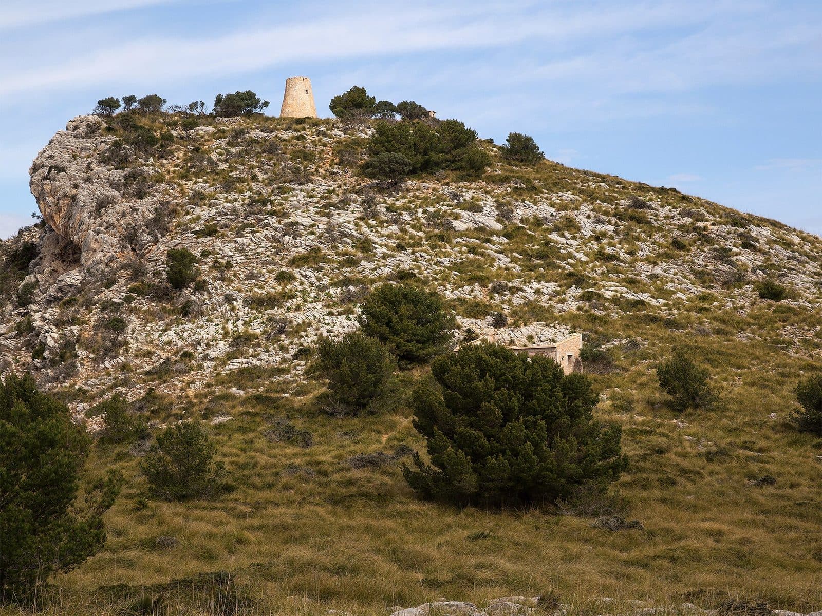

A historic site that is easy to overlook lies among the wooded slopes above Canyamel: no tower visible from afar remains of Talaia Vella, mainly just the circular base formed by a few surviving stones. This understated evidence is precisely what makes the ruins appealing, as your gaze must shift away from the coastal panorama and focus on the traces in the rocky terrain.
Talaia Vella was one of the watch posts along Mallorca’s coast and is now a hiking destination on Cap Vermell. The route climbs quickly from the residential area of Canyamel through pine forest. As the elevation increases, views open up over the beach, the resort, the valley, and the coast of the Artà Peninsula. The visit is therefore especially worthwhile for people who enjoy combining scenery and history. Anyone who climbs solely expecting a mighty tower will be surprised by the few remaining sections of masonry. Those who enjoy reading a historic landscape, however, can discover the site of a former coastal lookout and understand why these heights above the sea were chosen.
Talaia Vella can be incorporated into a longer hike across Cap Vermell that also includes the better-preserved and restored Talaia Nova, also known as Torre Nova of Cap Vermell. However, the two sites should not be confused: the destination described on this page is explicitly the old ruin, now recognizable only by its base.
History and significance
A ring of stones is all that directly tells of the former structure today. Talaia Vella was a coastal watchtower on Cap Vermell and thus belonged to the historic practice of surveying terrain from elevated points above the sea. Its location illustrates its purpose more clearly than any lengthy explanation: from the heights above Canyamel, the view extends across the bay, the valley, and sections of the Artà Peninsula’s coast.
Coastal surveillance on Cap Vermell
The term “Talaia” refers to a watchpoint or lookout. At Talaia Vella, this function was tied to the coastal area, as the site high above Canyamel made it possible to survey the surroundings from a greater distance. Although almost none of the rising masonry survives, the strategic logic of the location remains clear: the ruins do not lie down in the sheltered valley but on Cap Vermell, where land and sea can be observed together.
Historic coastal watchtowers often reveal their significance only in relation to one another. On the hike, Talaia Nova provides a second watchtower counterpart to Talaia Vella. The suffix “Vella,” meaning “old,” distinguishes the older site from the newer lookout. The difference is immediately apparent on site: while Talaia Nova is recognizable as a tower and has been restored, Talaia Vella has been reduced to a few stones and its ground plan.
From watch post to archaeological monument
Talaia Vella is now designated a Bien de Interés Cultural, a protected cultural asset. This status suits a place whose value does not depend on spectacular features. What matters is the historic site, its surviving base, and its role within the coastal landscape. The ruins demonstrate how little can sometimes be enough to mark the location of an earlier structure clearly.
A visit therefore requires a different perspective from viewing fully preserved architecture. There are no doors, stairs, or accessible interior. Instead, the central question is why people established a lookout at this particular spot. As soon as views of Canyamel and the sea open up beyond the pines, the terrain almost answers that question itself.
What to see
The most important discovery is inconspicuous: the round base of Talaia Vella can be made out among rocks and vegetation. Only a few stones reveal the former outline of the tower. Anyone expecting a tall defensive tower could walk past the site without properly noticing it. Looking slowly at the ground is more important here than searching for a silhouette on the horizon.
The circular tower base
What mainly survives of Talaia Vella is the foundation of the round structure. The stones no longer form a complete, tall ring of masonry but merely mark the base. For this reason, the ruins should be viewed from several directions. From a low angle, the curve often stands out more clearly against the uneven ground than when viewed directly from above.
The surviving remains do not allow visitors to explore any rooms. There is no chamber, stairway, or platform that can be entered. The visible feature is the ground plan itself. It makes the tower’s former location tangible without fully defining its original appearance. Talaia Vella is therefore more an archaeological trace than a picturesque ruin.
The location above Canyamel
The terrain surrounding the remains of the walls is an essential part of the experience. The ascent begins in the built-up area and quickly gains height through the pine forest. The houses of the settlement and Platja de Canyamel gradually recede farther below. Views of the beach and bay open between the trees; higher up, the shape of the valley enclosed by hills also becomes clear.
The view is not an incidental addition to the ruins but explains the choice of lookout site. From the heights of Cap Vermell, the coast and hinterland can be surveyed together. This makes Talaia Vella particularly interesting to visitors who do not want to view historic sites in isolation: the former tower has almost disappeared, but its position within the landscape remains clearly perceptible.
Talaia Vella and Talaia Nova
The two lookouts are often visited together on hikes around Cap Vermell. Distinguishing between them is essential for orientation: Talaia Vella is the severely ruined site with the round base, while Talaia Nova is the much better-preserved, restored tower. Photos showing a tall tower therefore do not depict the ruins discussed here.
Comparing them makes the excursion especially informative. Talaia Nova presents a watchtower as a physical structure; at Talaia Vella, its former existence must be read from the evidence on the ground. Linking both stops therefore does not provide a repetition but two very different impressions of historic coastal surveillance.
The landscape of Cap Vermell
The route passes through a combination of pine forest, rocky slopes, and open coastal views characteristic of Canyamel. Below lies the resort at the end of the Torrent de Canyamel valley. To the north, the terrain rises toward Cap Vermell, whose coast is also home to the Coves d’Artà. The ruins thus form a quiet counterpart to the better-known attractions by the sea.
The perspective changes again during the descent. What was behind you on the outward route now moves into the foreground: the settlement, the beach, and the wooded slopes around the bay. The panoramic view is not confined to a constructed terrace but appears in stages along the trail. The finest views are therefore not necessarily found directly beside the few surviving stones.
Visiting Talaia Vella
The first section quickly reveals the nature of the excursion. From Carrer de l’Ermita, a path climbs briskly through the pine forest. A wooden marker with a blue ribbon indicates the trailhead; additional wooden posts, painted marks on rocks, and cairns help with navigation along the way. Near the start, there is also a heavily weathered information board about Mallorca’s towers and Talaia Nova.
The direct hiking excursion
One described option connects the watchtowers on Cap Vermell along a route of 3 kilometers. The entire tour, including breaks, is stated to take 2 hours and 15 minutes; its difficulty is classified as easy to moderate. This time includes not only the brief viewing of Talaia Vella but also the ascent, the paths between the sites, scenic breaks, and the return journey.
Only a short amount of time is needed at the ruins themselves because the route there is the main part of the visit. It therefore makes sense to plan based on the duration of the complete hike rather than minutes spent at the structure. Anyone who takes photographs, enjoys the coastal views, and carefully searches for the round base will spend most of the excursion away from the actual ruin site.
The longer circuit across Cap Vermell
A more extensive circular hike follows old routes across Cap Vermell to Talaia Vella, passes a roofless former Carabineros building, and continues to the restored Torre Nova of Cap Vermell. This option is documented as covering 6.19 kilometers, with a positive elevation gain of 294 meters and a highest point at 227 meters. The paths are described as clearly recognizable and marked, with a moderate elevation difference.
This circuit is suitable if Talaia Vella is to be experienced not as a single turnaround point but as part of a connected scenic and historic tour. The structures’ different states of preservation add variety. At the same time, the time and fitness required are considerably greater than for the shorter option.
Navigation along the route
Markers are no substitute for careful route planning. Wooden posts with blue ribbons, marks on rocks, and stacked stones help with navigation on the shorter tour described. At a junction in the upper section, a signposted branch leads to Talaia Nova. Since Talaia Vella itself barely rises above the ground, its position should be checked on a hiking map before setting out; a tower on the horizon is not a reliable sign to follow here.
Current opening hours and an admission price have not been recorded. Since Talaia Vella is visited as a ruin site during a hike, current access conditions and any local notices should nevertheless be checked before departure. The condition and accessibility of the routes used are more important than ticket-office or sightseeing hours.
Getting there and parking
The road journey does not end at Talaia Vella. All stated distances and driving times lead only to Canyamel Platja; from there, the hiking approach onto Cap Vermell begins. This is crucial when planning your time because the actual approach to the ruins starts in the village and then climbs through the pine forest.
From Palma Airport
The road distance from Palma Airport to Canyamel Platja is 77 kilometers. The drive takes around 65 minutes and follows the Ma-15, then the Ma-4030 and Ma-4040. In Canyamel, you will need to find a permitted parking place before continuing on foot. The trailhead for the shorter hike described is on Carrer de l’Ermita and is marked by a wooden post with a blue ribbon.
The driving time alone should therefore not be confused with the total journey to the ruins. Additional time is required for finding your way around Canyamel, preparing hiking equipment, and completing the ascent. Anyone setting out directly after a flight should also bear in mind that even the shorter tour is described as easy to moderate and involves considerably more than a stroll from a parking area to a viewpoint.
From central Palma
The road route from central Palma also follows the Ma-15, Ma-4030, and Ma-4040 to Canyamel Platja. The distance is 79 kilometers, and the drive takes around 72 minutes. These details also apply only as far as the coastal resort because the final section to Talaia Vella is completed on foot along an ascending hiking trail.
The route crosses Mallorca largely from west to northeast. For a day trip, it is therefore important to plan not only the hiking time but also the return drive. Talaia Vella is less suitable as a brief stop on an island tour than as part of a deliberately planned stay in Canyamel and on Cap Vermell.
By bus to Canyamel
Possible stops for the coastal area include Canyamel – Coves d’Artà and Cala Provençals. No direct route leads from a bus stop to the ruins; even when arriving by public transport, the hike onto the ridge remains part of the visit. Before traveling, check which stop best suits the chosen route and intended trailhead.
Bus lines to Talaia Vella at a glance
| Line | Route | Departures/day | First | Last |
|---|---|---|---|---|
| 424 | Cala Rajada - Portocristo | 42 | 08:18 | 23:10 |
| 423 | Font de sa Cala - Cala Rajada | 28 | 08:00 | 21:55 |
From the official GTFS feeds (TIB/SFM), no real-time data. The figures cover all stops in the town; weekend and holiday services differ — check with the operator before travelling.
Getting there by bus
Canyamel - Coves d'Artà (14035) · 0.9 km as the crow flies
- 424Cala Rajada - Portocristo · Daily
Cala Provençals (14040) · 1.9 km as the crow flies
- 423Font de sa Cala - Cala Rajada · Daily
Timetable data: official GTFS feeds (TIB/EMT), no real-time — check with the operator before travelling.
Nearby attractions
Viewed from the slope, Canyamel appears as a settlement between the beach, Torrent, and wooded heights. The resort belongs to the municipality of Capdepera and lies at the end of the small Torrent de Canyamel valley. Cap Vermell borders the bay on its northern side, while opposite, the slopes rise toward Cap des Pinar. This sheltered location shapes both the beach and the ascent to Talaia Vella.
Canyamel Platja
Platja de Canyamel is the obvious addition after the hike. The trail initially provides views of the beach from above before you return to the bay below. This change of perspective makes the combination particularly appealing: in the morning or before the ascent, the ridge is merely a wooded backdrop; after the visit, you can identify the location of the former coastal lookout within it.
Canyamel is a relatively quiet coastal resort with restaurants, smaller shops, and tourist facilities near the beach. It developed into a holiday destination comparatively late. Its name recalls the historic cultivation of sugar cane; “canya de mel” roughly means honey cane. Although this local history is not directly relevant to Talaia Vella, it explains the name of the landscape once surveyed by the former watch post.
Cap Vermell and Coves d’Artà
The Coves d’Artà lie on the coast of Cap Vermell and can easily be included in an excursion to Canyamel. They offer a clear contrast to the open hike: an underground cave landscape on one hand and an airy ridge trail with the remains of coastal watchtowers on the other. The two attractions should be scheduled separately so that the ascent to Talaia Vella is not squeezed between other activities.
The longer circuit on Cap Vermell also touches on several layers of coastal-surveillance history. In addition to Talaia Vella and Talaia Nova, the described route passes a roofless, poorly preserved building once used by Carabineros. It is not part of Talaia Vella but helps visitors understand the cape as a coastal area monitored over a long period.
Capdepera and Cala Ratjada
Capdepera and Cala Ratjada are larger settlements in the northeastern part of the island near Canyamel. They are suitable as additional stops on a day trip without reducing Talaia Vella to a mere stopover. Capdepera adds a cultural highlight with its historic townscape, while Cala Ratjada offers a livelier coastal resort. Canyamel nevertheless remains the logical starting point for the hike itself.
The place it belongs to
Canyamel Platja in the place guidePractical visitor information
The few stones of Talaia Vella reward attention rather than haste. Anyone looking only for a tall tower is more likely to notice Talaia Nova. At the old lookout, search the ground for the circular base. Do not step onto the ruins or attempt to make them more visible by moving stones: their value lies precisely in the surviving archaeological evidence.
Footwear and trail conditions
The approach is a hike with a rapid gain in elevation, not a level promenade. Secure footing on the woodland and rocky paths is more important than urban walking comfort. Closed shoes with good tread are therefore better suited to the terrain than beach footwear. Even on the shorter option, enough time should be allowed for a controlled descent.
Wooden markers, painted rock signs, and cairns assist with navigation, but the barely visible ruins require additional attention. A hiking route saved in advance is particularly helpful because Talaia Vella itself does not appear as a prominent tower above the trees. At the junction for Talaia Nova, you should also check which option you actually intend to follow.
Sun, water, and breaks
The initial ascent passes through pine forest, while more exposed views open up higher on the route. Shadier sections therefore alternate with areas more exposed to the sun. Water, sun protection, and headwear belong in your backpack even if conditions at the starting point in the village feel comfortable. Breaks can usefully be combined with viewpoints along the trail.
The published tour times already include stops but do not guarantee the duration for every walking pace. The elevation difference on the longer circuit and the need to search carefully for the ruins can extend the excursion. Anyone combining the trip with the beach or caves should allow sufficient time between activities.
With children
The shorter hike is described as easy to moderate, while the longer circuit and its elevation difference are classified as moderate. Whether it is suitable for children therefore depends less on age than on sure-footedness, stamina, and experience on ascending natural trails. The ruins themselves do not offer a staged attraction; they become interesting to children mainly when the search for the round foundation and the former role of a coastal lookout are explained.
Young children require close supervision on uneven terrain. They should also know in advance that no fully preserved tower awaits at the destination. The real highlights are the route, the views, and the comparison with the better-preserved Talaia Nova.
What not to expect
No rooms, stairs, or tower platforms survive at Talaia Vella. The site consists of a few stones from which the circular base can be identified. Even the best coastal views may not be directly beside the foundation; they open up at various points during the ascent and descent.
With these expectations, the visit becomes a coherent experience. The ruins are not a monumental standalone structure but a historic trace within a hiking landscape. Anyone who regards the route as an essential part of the destination will experience Talaia Vella not as a disappointing stone circle but as a quiet key to understanding Cap Vermell.
Local insider tips
Look at the ground, not the horizon
Only the circular base formed by a few stones remains of Talaia Vella. The tall, restored tower on Cap Vermell is Talaia Nova. At the old lookout, it therefore pays to examine the ground slowly.
Choose the right trailhead
The shorter tour described begins on Carrer de l’Ermita. A wooden post with a blue ribbon marks the trailhead; additional posts, marks on rocks, and cairns help with navigation along the route.
Enjoy the views along the way
The views are not confined to the ruin site. Even during the ascent through the pine forest, Canyamel and the beach recede farther below; open coastal views appear at several points along the route.
Compare old and new
Anyone combining Talaia Vella and Talaia Nova on one hike will see two contrasting states of preservation: only the round ground plan here and a restored tower there. This makes the history of the lookout site especially vivid.
Allow more time for the circuit
The extensive circuit across Cap Vermell covers 6.19 kilometers and also passes a former Carabineros building before reaching Torre Nova. With 294 meters of positive elevation gain, it is considerably more than a brief visit to the ruins.