
Necròpolis de s’Illot des Porros: Mallorca’s Island Necropolis
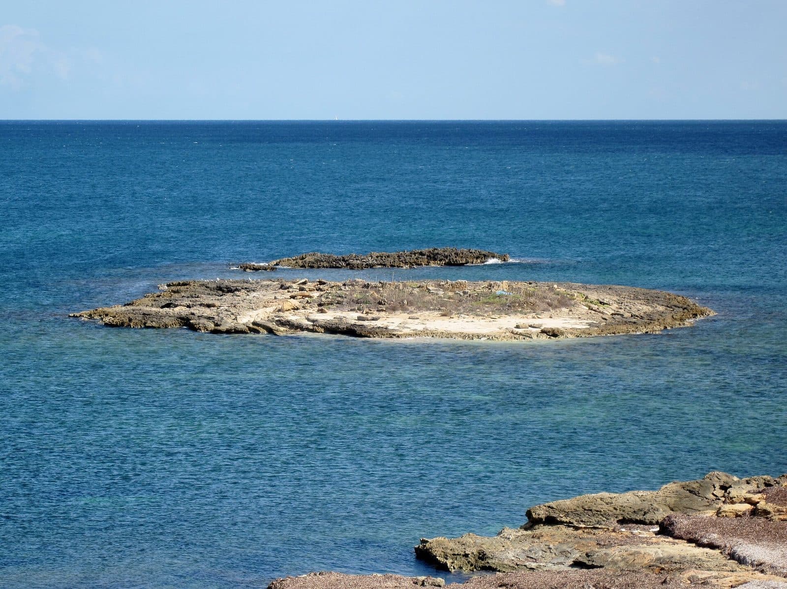

Even its name points out toward the water: Necròpolis de s’Illot des Porros lies on a small, flat island off Mallorca’s coast. Beneath its unassuming surface is an unusually complex archaeological site. Rock-cut chambers, walls made from large stone slabs, and traces of different burial rituals tell of use extending far beyond a single era.
Unlike at an easily accessible excavation, exploring the site often begins on the opposite shore. The island is separated from the mainland by the sea and therefore cannot be entered like an ordinary open-air museum. Visitors should not expect an exhibition with display cases, but should instead learn to read an archaeological landscape: the islet’s low silhouette, the location of the necropolis, and its relationship with the neighboring coast.
For those interested in archaeology, Necròpolis de s’Illot des Porros is particularly worthwhile because of its unusual sequence of uses. An early phase, when it did not yet serve as a cemetery, was followed by individual burials, children’s graves, and several large communal chambers. The site was even used for burials again in Roman times.
A visit therefore requires some preparation. The archaeological remains themselves lie on the island, and many architectural details can be seen only to a limited extent from the mainland. Those who know the history beforehand, however, will see more than a low rock in the sea: a burial site transformed over centuries, whose location is itself part of its significance.
History and significance
When archaeologist Miquel Tarradell brought the site to public attention in 1957, the scientific investigation of a place that proved far more complex than a single Talayotic tomb began. Excavations continued in several stages and lasted until 1998. An archaeologically used area of around 450 square meters was investigated on an island covering approximately 3.000 square meters in total.
The early settlement phase
The oldest traces do not yet belong to the necropolis. Between 1400 and 850 BCE, during the Middle and Late Bronze Age and the beginning of the Iron Age, the islet was used in other ways. Possible explanations under discussion include maritime contacts and the exchange of goods, as well as ritual activities associated with an artificial cave on the opposite coast.
Only part of these early structures survived. The later cemetery cut deeply into the terrain and destroyed older remains. This very layering is archaeologically revealing: s’Illot des Porros did not suddenly become a sacred place, but was repeatedly reinterpreted and reshaped over a long period.
The Iron Age cemetery
The second major phase of use began around 600 BCE. Initially, tomb types were constructed that resembled the so-called Micronavetes of the neighboring necropolis of Son Real. These were small stone-built tombs whose forms drew on the architecture of the contemporary world of the living.
Later, a separate area was created for children’s burials. The deceased were interred there in pits and containers made of Marès, the sandstone widely found in Mallorca. This section of the cemetery makes it clear that age, burial type, and possibly status within the community played a role in the choice of grave.
The large communal chambers
From around 400 BCE, the site changed fundamentally. First, a large chamber for communal burials was created, followed later by two additional rooms. Together, these structures held the remains of approximately 260 deceased individuals. Inhumations alternated with cremations using lime; at the same time, the rooms were repeatedly cleaned and prepared for new burials.
The cemetery remained in use into Roman times. Later inhumations from the early Roman Imperial period were found inside the collective burial chambers. s’Illot des Porros was therefore not a static cemetery, but a place of remembrance continually reshaped over generations.
A late burial during the plague year
One extraordinary episode reaches far beyond prehistory. In 1348, a deceased person was secretly buried on the islet and is considered the first known victim of the great plague epidemic in Mallorca. A medieval death thus appears among the Iron Age and Roman burials. The secluded island was apparently chosen once again as a place where a feared deceased person could be buried outside the ordinary living environment.
What to see
From the coast, s’Illot des Porros initially appears low and barren. The island rises only slightly above the sea and takes its name from the wild leeks that grow there but are absent from the neighboring Mallorcan shore. Its archaeological significance is revealed not by a monumental exterior façade, but by rooms cut into the rock and walls added around them.
The Micronavetes
The oldest graves of the necropolis itself were small structures comparable to a phase of the neighboring tombs at Son Real. The term Micronaveta refers to their reduced form, reminiscent of naveta-style architecture. In the burial culture of the period, forms familiar from the world of the living were transferred into architecture for the dead.
These early graves mark the beginning of a remarkable development. The burial site did not grow according to a uniform plan. New types of tomb were added, older areas were built over or altered, and small individual structures developed into a cemetery with large, collectively used interior spaces.
The children’s burial ground
A separate section of the necropolis was reserved for children’s burials. Here, simple burial pits lay beside urns or stone containers made of Marès. The remains differ clearly from the later communal chambers and show that not all deceased individuals were buried in the same way.
When viewing the islet, it is easy to underestimate this area because it lacks the visible impact of large stone walls. Archaeologically, however, it is among the site’s most informative sections: it documents a deliberately organized landscape of the dead and preserves evidence of community members who often remain invisible in monumental narratives.
The first communal chamber
The oldest of the large collective structures was created from around 400 BCE. It has a rounded, approximately semicircular or apsidal end. Part of the room was worked directly into the natural rock, while other sections were built with massive stone slabs.
This combination of rock and masonry defines the overall impression. The builders used the natural surface not merely as a foundation but made it part of the tomb architecture. As a result, the room lay partly below the original ground level and was reached through an entrance with steps.
The two later chambers
After the first structure, two further communal rooms were added. They too were partly carved out of the rock and partly formed by walls made from large slabs. Their apsidal plans, internal columns, and stepped entrances resemble contemporary Mallorcan sanctuaries in several respects.
This similarity does not mean that the chambers were ordinary temples. Instead, it shows how carefully the space for the dead was designed. Columns divided the interiors, the rounded ends gave the rooms a clear orientation, and the steps marked the transition from the surface into the burial area.
Traces of the burial rituals
Bodies were not merely laid inside the chambers. Archaeological evidence confirms both inhumations and cremations using lime. Between burials, the rooms were cleaned or purified. The burial chambers therefore remained accessible and were repeatedly entered, altered, and reused.
Imagining the chambers as sealed crypts misses their true character. They were ritual spaces used over long periods, where the community interacted with its dead. Only this sequence explains why the remains of numerous people lay within a small number of large structures.
The Roman burials
Burials later took place again inside the collective chambers. These latest ancient inhumations already belong to the early Roman Imperial period. In a sense, they lie within an older architecture of remembrance: people of the Roman era chose rooms that had been associated with death and ancestors for centuries.
The later graves are therefore not an insignificant addition. They show that knowledge of the site continued or that its visible structures were still regarded as a suitable place for burial. Traces of Bronze Age use, Iron Age funerary architecture, and Roman reuse meet here within a small area.
Visiting the site
The decisive moment comes at the shore: the excavation site is not beside the sea but on the islet itself. A visit therefore works differently from one to the nearby necropolis of Son Real on the mainland. Without suitable and legally permitted access, s’Illot des Porros remains a place that must initially be viewed from a distance.
Viewing from the mainland
From the opposite stretch of coast, the island’s low form can be clearly understood within its landscape. The deliberate separation between living space and burial place becomes particularly evident here. The water is not a decorative backdrop but continues to determine how the site is perceived and reached.
Architectural details such as columns, steps, and individual burial pits cannot be studied reliably from the shore. It therefore helps to know the sequence of structures before visiting. This prevents the island from being confused with the large mainland necropolis and makes it possible, at least conceptually, to assign the visible walls to the different phases.
Access to the island
Older visitor reports describe access as difficult and mention swimming or using a small boat as possibilities. However, this is not a reliable basis for a spontaneous landing. Currents, waves, rocky shores, and the need to protect the archaeological remains demand restraint. Viewing the site from the mainland is the sensible standard form of visit unless a current, officially regulated crossing is available.
The burial chambers are fragile original remains, not scenery for climbing. Even if approaching the site is permitted, the tops of walls, pits, and rock edges should not be stepped on. Stones that appear loose are also part of the site and must remain where they are.
Timing and crowds
There is no reliably established visit duration for simply viewing the island from the shore. Those who only wish to see the island can keep the stop brief; those who include the coastal landscape and the archaeological connection with Son Real should allow considerably more time. A documented circular walk between the archaeological sites and the lighthouse viewpoint covers 12,0 kilometers and is listed as taking 3:03 hours.
Reliable, site-specific visitor numbers for different times of day are not available. In Mallorca, the summer months are generally the busiest, while spring and autumn tend to be quieter for walks. Regardless of crowds, the visit should take place in sufficient daylight so that rock edges, coastal paths, and the contours of the islet remain clearly visible.
Opening hours and admission
No reliable current opening hours or confirmed admission price are recorded for Necròpolis de s’Illot des Porros. Because access rules at archaeological sites can change, both points should be checked with an official local authority immediately before traveling. This is especially important if more than viewing the site from the shore is planned.
Getting there and parking
The recorded road routes lead as far as Urbanització Montfarrutx, not to the offshore island and not automatically to a confirmed access point on the shore. This distinction is important: the road navigation destination does not replace checking the final coastal section or obtaining official permission to enter s’Illot des Porros.
From Palma Airport
From Palma Airport, the road distance to Urbanització Montfarrutx is 64 kilometers. The drive takes around 64 minutes and follows the Ma-30, then the Ma-13, and finally the Ma-3400. These directions expressly end in the Urbanització; the final section to the coast or a suitable place from which to view the necropolis must be checked separately.
For this destination in particular, navigation should not rely on a name search alone. Necròpolis de s’Illot des Porros must not be confused with the larger necropolis of Son Real on the mainland. Before departure, it is therefore advisable to check which viewpoint or coastal access point is actually intended.
From central Palma
From central Palma, the road distance to Urbanització Montfarrutx is 61 kilometers. The drive takes around 69 minutes. The route initially follows the Ma-13 and then continues along the Ma-3400 and Ma-3440. Here too, the distance and driving time refer exclusively to Urbanització Montfarrutx.
For the final section, signs, property boundaries, and current access information are decisive. A seemingly short line on the map may be interrupted at the coast by rocks, vegetation, or a lack of public passageways. Cars should be left only in clearly permitted parking spaces; driveways and narrow paths must be kept clear.
Bus and onward journey
No bus stop is recorded in the immediate area. It is therefore impossible to provide a reliable short walking route from a particular stop for travel by public transport. Those arriving without a car should fully check the current regional connection to a suitable starting point and the subsequent coastal route in advance, rather than waiting until arrival to look for onward transportation.
Regardless of the means of transport, the actual destination remains offshore. Even arriving directly at the correct stretch of coast does not mean the island can be entered. For many visitors, the journey deliberately ends at the shore—with the islet and its necropolis in view.
Nearby attractions
Urbanització Montfarrutx is the destination recorded in the travel data for northeastern Mallorca. For an archaeological visit, however, the transition to the coast matters more than the development itself. Only there does it become clear why a small island could have been perceived as a special place over many generations.
The necropolis of Son Real
The most important thematic addition is the necropolis of Son Real on the mainland. The two sites can be closely compared but must not be confused. At Son Real, numerous small tomb structures stand directly in the coastal landscape; on s’Illot des Porros, by contrast, the remains include the three large communal chambers partly worked into the rock.
Combining the two sites reveals the different scales of prehistoric funerary architecture. On the mainland, forms such as Navetes and small Talayot-style structures can be studied directly. The island site shows how these developed into a complex characterized more strongly by interior spaces with steps, columns, and collectively used chambers.
The artificial coastal cave
An artificial cave on the coast is also cited in connection with the early, non-funerary use of s’Illot des Porros. According to the archaeological description, it lies 250 meters away and may have been associated with rituals. This interpretation is not conclusive, but it makes clear that even before its use as a cemetery, the islet formed part of a broader coastal landscape.
Coastal paths and viewpoints
Those wishing to incorporate the archaeological stop into a hike can follow a documented circuit to the necropolis of Son Real and a viewpoint at the lighthouse. It covers 12,0 kilometers, takes 3:03 hours according to the route information, and has an elevation gain of 30 meters. Despite the small elevation difference, the distance requires a good basic level of fitness.
Shorter additions include the beaches and coastal areas of Son Bauló, Son Serra de Marina, and Platja de Muro. They should not displace the archaeological focus, but they can help structure a longer stay on Mallorca’s northeastern coast.
The place it belongs to
Urbanització Montfarrutx in the place guidePractical visitor information
The site rewards preparation more than spontaneity. Without knowledge of the excavations, visitors initially see a small island; with some background information, its low walls can be understood as the remains of a landscape of the dead transformed over centuries. A brief summary of the construction phases on a phone or in a notebook is more helpful on site than expecting large information boards.
Footwear and coastal terrain
Sturdy, closed shoes are the sensible choice for reaching a viewpoint on the shore. Coastal rocks, sand, and uneven paths require more grip than an urban promenade. This is especially true when viewing the island is combined with the longer walk to the archaeological sites of Son Real.
Sun, water, and weather
The archaeological landscape lies exposed on the coast. Sun protection and sufficient drinking water should therefore be carried even if only a brief stop is planned. Wind and sea conditions affect not only comfort but also the visibility of low wall remains. In rough seas, any attempt to approach the water should be avoided.
Visiting with children
For children, the idea of a prehistoric island of the dead can be very vivid. The visit works particularly well if it is explained beforehand that people built not only individual graves here, but entire chambers used for repeated burials. Constant supervision is required on the rocky shore, however; the island should not be presented as a swimming destination or adventure playground.
What not to expect
s’Illot des Porros is neither a traditional museum nor an easily walkable ruined city. Finds are not presented in an exhibition on the island, and many architectural details are difficult to recognize from the mainland. Its appeal lies in the original setting and the long sequence of uses—from the Bronze Age and the Iron Age cemetery to Roman and medieval burials.
Those who primarily want to see easily accessible tomb forms from close range should also plan to visit the neighboring necropolis of Son Real. Those who want to understand how landscape, separation by water, and collective memory interact will find an exceptionally concentrated setting at Necròpolis de s’Illot des Porros.
Local insider tips
Identify the islet first
The burial chambers of s’Illot des Porros lie on the small island, not in the necropolis of Son Real on the mainland. First distinguish the two sites geographically—then the significance of the island setting becomes clear.
Look for the construction phases
The three large chambers are only part of the story. First consider the older Micronavetes and the children’s burial area; only afterward did the communal rooms, partly worked into the rock, appear.
Combine it with Son Real
The mainland necropolis of Son Real offers close-up views of small naveta- and Talayot-style tomb structures. The comparison explains better than an isolated view what is unusual about the islet’s collective rock-cut chambers.
Do not swim across spontaneously
Older reports mention swimming or using a small boat for access. Because of waves, rocks, and the fragile archaeological site, however, the island should be entered only under a current, officially permitted arrangement.
Make archaeology a hiking day
A documented circuit links the area with the necropolis of Son Real and a lighthouse viewpoint. It covers 12,0 kilometers, has an elevation gain of 30 meters, and is listed as taking 3:03 hours.