
poblat talaiòtic de ses Païsses near Artà
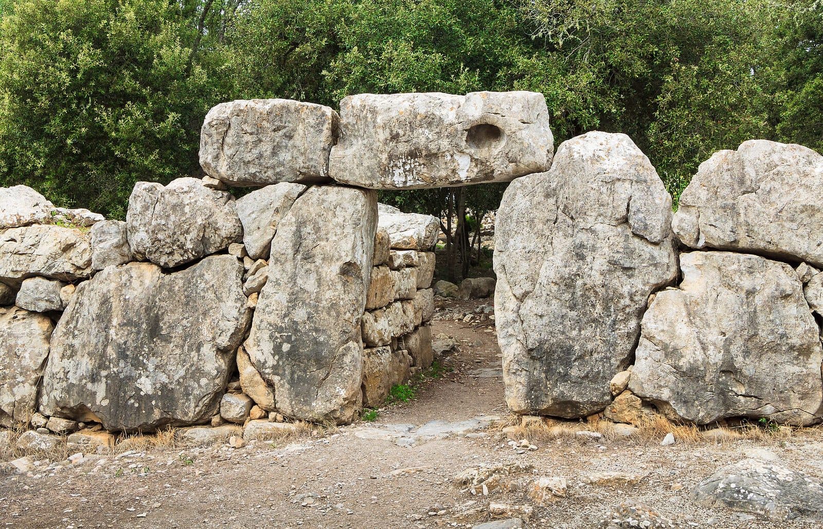

The gateway immediately changes your sense of scale. Three enormous stone blocks form the entrance, beyond which walls and building remains lead into a settlement whose origins reach far back beyond the Roman conquest of Mallorca. The poblat talaiòtic de ses Païsses lies on the southeastern edge of Artà and is one of the island’s largest and best-preserved Talaiotic villages.
The real exhibits are wall structures, passageways, house plans and the central talaiot. The stones reveal how a community expanded the core of its settlement over centuries, added homes and eventually enclosed it with a mighty wall. What makes the site particularly impressive is its completeness: not merely a single surviving tower, but an elliptical settlement area with fortifications, a gateway, a central monument and several excavated buildings. At the same time, a large part of the interior has yet to be investigated archaeologically. The visible and the hidden lie unusually close together here.
The visit is worthwhile for history enthusiasts as well as travelers who want to discover northeastern Mallorca beyond its coast and swimming coves. Even without prior archaeological knowledge, the site becomes understandable if you begin by following its broad outlines: from the monumental entrance along the surrounding wall to the talaiot, and from there to the adjoining rooms.
History and significance
The talaiot as the starting point
The central talaiot came first. The settlement is thought to have been founded around 850 BC; the massive round structure formed its core. Other constructions later grew around this center, including numerous buildings classified as living quarters. Ses Païsses was therefore not created according to a single, finished building plan. The site developed gradually, and this evolution can still be recognized in the terrain today.
Talaiots are characteristic megalithic structures of the Balearic Islands. Their name was applied to an entire prehistoric cultural period, but their specific purpose has not been conclusively established. Communal, ceremonial and economic functions have all been proposed for such buildings. The central structure should therefore not be interpreted too hastily as merely a watchtower or house. What is certain is its importance as the architectural center around which Ses Païsses took shape.
The walled settlement
The great enclosing wall was not added until after the settlement’s core had emerged. Its construction is dated approximately between 650 and 540 BC. It enclosed the growing community within a clearly defined village and made access controllable. The fact that much of the wall’s circuit can still be traced distinguishes Ses Païsses from many archaeological sites where only isolated building remains survive.
The site has an elliptical layout, covers 13.500 square meters and is enclosed by a 374-meter-long wall. These figures become tangible on site: the entrance is not the façade of a single building but the threshold to an entire settlement area. Beyond it were different rooms, paths and communal buildings within a clearly marked boundary.
Roman period and decline
The Roman conquest of the Balearic Islands in 123 BC marked the beginning of Ses Païsses’ decline. The settlement was gradually abandoned and partly destroyed. Its end was therefore not a clean break after which the site immediately disappeared. Instead, the village slowly lost its former role as Mallorca’s political and social conditions changed fundamentally.
For visitors, this long development is more important than the idea of a single “Bronze Age village.” Ses Païsses preserves several phases: the early central talaiot, rooms added later, the subsequent fortifications and traces of a gradual decline under Roman influence. The site therefore tells a story not only of construction but also of rebuilding, continued life and abandonment.
Excavations and protection
In 1946, Ses Païsses was declared a historic-artistic monument. The first systematic excavations were led by the Italian archaeologist Giovanni Lilliu, who wanted to investigate connections between the megalithic structures of Mallorca and Sardinia. Between 1959 and 1963, he concentrated on the central area with the talaiot and adjoining rooms. After a lengthy interruption, work continued in other sectors.
A large proportion of the buildings remains unexcavated. This explains why the site feels both complete and mysterious: the enclosing wall conveys the size of the village, but only selected areas openly reveal its internal organization.
Miquel Costa i Llobera
A monolith dedicated to the Mallorcan poet Miquel Costa i Llobera stands in front of the main entrance. He chose Ses Païsses as the setting for his poem “La deixa del geni grec,” published in 1900. The monument is a reminder that the prehistoric walls were not solely the subject of scientific research. They also entered Mallorca’s literary imagination and became the stage for a story about the island’s early world.
What to see
The monumental main gateway
The most powerful first impression belongs to the gateway on the east-southeastern side. Two large upright stone blocks support a mighty lintel; no mortar holds this construction together. The entrance appears both simple and precise. There is no decoration to distract from the material, making the technical and communal effort required to move and position the blocks all the more apparent.
The gateway is an especially good place to study how the entire fortification was built. More vividly than any explanation, the portal demonstrates how skilled its builders were at handling weight, bearing surfaces and balance. It is therefore worth pausing before walking through: from outside, the gateway and surrounding wall can be understood as a single structure, while directly beneath the lintel you feel the narrowness of the controlled passage. Once through, the perspective changes. The wall is no longer a façade but the boundary of a village whose buildings develop toward the center.
The surrounding wall
The 374-meter-long enclosing wall follows the settlement’s elliptical layout. It has not survived to the same height everywhere, but it can still be perceived as a continuous boundary around the site. Viewed from inside, it shows how much space the community occupied. From outside, the large blocks are particularly striking, fitted into a stable structure without being cut into regular ashlar shapes.
The surrounding wall was built later than the talaiot and the first structures adjoining it. This sequence is essential to understanding the site: Ses Païsses did not begin as a fully fortified settlement. Only an already established and growing community received its monumental boundary. Moving between the center and the perimeter during the tour therefore also means reading a chronological sequence in the landscape.
The central talaiot
At the center stands the round talaiot, the oldest core of the village. It survives today as a massive stone building with adjoining structures. Its position makes clear why the later settlement was organized around it. Even in its ruined state, it does not resemble an ordinary house foundation but a monument to which other rooms relate.
The precise function of such talaiots remains uncertain. Their architectural relationships are therefore all the more revealing: at Ses Païsses, it is possible to observe how the central building became the starting point for an increasingly densely occupied area. Rather than looking only upward and imagining a former tower, it is worth examining the points where other structures join it. There, wall joints and adjoining rooms tell the story of different construction phases.
The Sala Hipòstila
One of the site’s distinctive excavated areas is the Sala Hipòstila, the hypostyle hall. The term describes a room whose roof was supported by columns. The hypostyle hall therefore represents a different architectural concept from the open lanes and simple room plans surrounding it, making clear that the village did not consist of uniform huts. Different types of spaces required different structural solutions.
The hypostyle hall draws attention to supports, load-bearing structures and the organization of covered areas. Especially when compared with the massive talaiot and heavy outer wall, it demonstrates the architectural range found within the same settlement.
The horseshoe-shaped room
Another area investigated by Giovanni Lilliu is the horseshoe-shaped room. Its curved layout differs from the more rectangular plans of other buildings. Because many walls survive only in their lower sections, the shape is easiest to understand by changing position and following the course of the wall across several layers of stone.
The room is a good example of how Ses Païsses should be read. Individual stones reveal little; lines, transitions and connections are what matter. Those who take their time will recognize deliberately designed floor plans behind the apparently irregular remains. A definite use should not, however, be inferred from the shape alone.
Residential areas and rectangular houses
Alongside the central monumental structures, residential areas and so-called rectangular houses have been uncovered. Their lower walls demand more attention than the gateway because they impress not through height but through organization. Doorways, adjoining walls and separated areas make the settlement’s everyday life tangible, at least in spatial terms.
In these areas, attention shifts from the monument to the community. The large buildings explain why Ses Païsses is famous; the house plans show that people lived within the fortifications and repeatedly reorganized the available space. Because many internal structures are still underground, however, the visible network of paths represents only a section of the former village.
The holm oak grove
Ses Païsses lies within a grove of holm oaks that characterizes large parts of the archaeological site. In places, the trees obscure the overall view, but they create a distinctive visitor experience: walls and rooms appear one after another between trunks and canopies instead of being visible simultaneously across an open area. As a result, the terrain feels more like a discovered village than a geometrically exposed excavation plan.
The changing light can even help in reading the structures. Light falling from the side emphasizes edges and joints, while deep shadow causes some sections of wall to recede visually. Anyone wanting to take photographs or understand the floor plans should therefore view the same building from several directions. Ses Païsses rarely reveals itself at a single glance.
Visiting the site
From the entrance to the settlement core
The tour begins with a clear sequence: first the monolith for Costa i Llobera, then the megalithic gateway and finally the interior of the walled settlement. Beyond the gateway, the path leads toward the central talaiot and the rooms extending from it. It makes sense to retain this order because it clarifies the site’s development without requiring every section of wall to be explained individually.
A quick circuit requires considerably less time than a visit to a large museum. Anyone who wants to examine the gateway, talaiot, hypostyle hall, horseshoe-shaped room and residential areas carefully should, however, allow up to two hours. Visitors with an archaeological interest can spend longer studying wall connections and different construction phases; those who mainly want an overall impression can make their way through the site more quickly.
Learning to see instead of reconstructing
At first, the many low walls can look similar. A simple viewing sequence helps: begin by looking for the outer shape of a building, then find its entrances and internal areas, and finally examine its connection with neighboring rooms. In this way, apparently scattered stones become coherent floor plans. This works particularly well around the rectangular houses and the horseshoe-shaped room.
An audio guide for Ses Païsses is offered by Artà Travel. It can be useful because the site’s appeal does not lie in spectacular individual objects but in the spatial relationships between its buildings. Anyone who prefers to explore without a guide should at least know the names of the principal stops. The central talaiot, the Sala Hipòstila and the main gateway provide a good basic framework for the tour.
Light, shade and visitor numbers
The holm oak grove provides shade in many places and distinguishes Ses Païsses from completely open excavation sites. Nevertheless, the visit remains an outdoor experience, and not every section is equally protected. The light also changes how clearly the walls can be read: when light falls from the side, layers of stone and wall edges often stand out more clearly than under harsh overhead light.
Compared with many well-known attractions, the site is considered relatively quiet. This does not make it possible to identify a reliably visitor-free time of day. Anyone wishing to examine the gateway and central buildings in peace should avoid being under time pressure.
Before traveling, it is advisable to check with Artà’s official tourist information service. Older information online may be outdated. This applies especially outside the main travel season and on public holidays.
Getting there and parking
Via the Ma-15 to Artà
From Palma Airport, the road route follows the Ma-15 to Artà. It is 71 road kilometers to the town, and the drive takes around 59 minutes. From central Palma, the route also follows the Ma-15. It is 74 road kilometers to Artà, with around 66 minutes of driving time. These figures expressly apply to Artà and not directly to the entrance of the archaeological site.
The Ma-15 connects Palma with Artà through the eastern part of the island and is the principal route from both starting points. The short local approach to the archaeological site begins only at the southern edge of town. Anyone entering only “Ses Païsses” into a navigation system should make sure to select the archaeological village on Camí de sa Corballa near Artà.
The final section to Camí de sa Corballa
Ses Païsses lies southeast of the edge of town. In Artà, the approach is oriented around the former railway line and the road toward Capdepera. Camí de sa Corballa branches off at a roundabout, where the archaeological site is signposted. The narrow paved road leads out of the built-up area to the site.
The archaeological site is close enough to Artà to combine a town visit with the excavation, but it is not directly beside a major through road. The final section therefore requires a little attention. The approach feels more rural than the Ma-15, and the monumental gateway cannot be seen from the main road.
Parking and the remaining walk
There is a designated parking area at the site. From there, access continues on foot. Anyone already planning to see Artà can treat the excavation as a separate destination on the edge of town and return to the center afterward. This avoids searching for a single parking space that would ideally serve both the old town and the archaeological site. The two areas have different approaches and distinct characters.
By bus via Artà
The nearest regular bus stops are in Artà: Mercat d’Artà, Artà 1 and Artà 2. The archaeological site is not directly beside the bus stop; the final section must be covered on foot through or from the town. Camí de sa Corballa is the key destination for orientation.
The most convenient stop depends on the bus route used and your further plans in Artà. Mercat d’Artà is a good option if the visit is combined with the town center. Current connections should be checked before traveling, as timetables can vary seasonally and according to the day of the week.
Bus lines to poblat talaiòtic de ses Païsses at a glance
| Line | Route | Departures/day | First | Last |
|---|---|---|---|---|
| 411 | Cala Rajada - Manacor | 41 | 05:58 | 23:33 |
| 325 | Alcúdia - Cala Rajada | 26 | 09:10 | 21:55 |
| 421 | Colònia de Sant Pere - Artà | 24 | 07:45 | 19:40 |
| 411e | Cala Rajada - Palma | 16 | 08:55 | 23:40 |
From the official GTFS feeds (TIB/SFM), no real-time data. The figures cover all stops in the town; weekend and holiday services differ — check with the operator before travelling.
Getting there by bus
Mercat d'Artà (6010) · 0.4 km as the crow flies
- 411Cala Rajada - Manacor · Daily
Artà 2 (6001) · 0.5 km as the crow flies
- 325Alcúdia - Cala Rajada · Daily
- 411Cala Rajada - Manacor · Daily
- 411eCala Rajada - Palma · Daily
- 421Colònia de Sant Pere - Artà · Daily
Artà 1 (6002) · 0.5 km as the crow flies
- 325Alcúdia - Cala Rajada · Daily
- 411Cala Rajada - Manacor · Daily
- 411eCala Rajada - Palma · Daily
- 421Colònia de Sant Pere - Artà · Daily
Timetable data: official GTFS feeds (TIB/EMT), no real-time — check with the operator before travelling.
Nearby
Artà
Artà is only a short distance away and is a good place for a break or a walk through its streets. The combination makes particular sense because the archaeological site itself is designed neither as a large museum operation nor as a full-day open-air attraction.
Artà also provides an appropriate historical context. The prehistoric settlement leads the imagination toward later periods of island history that are much more visible in the townscape. Those who visit Ses Païsses first often look more consciously afterward at the town’s walls, location and building materials. In the reverse order, the quiet archaeological site provides a focused conclusion after the livelier center.
Northeastern Mallorca
Anyone traveling by car can incorporate the visit into a route through the northeast. Artà is a suitable starting point for the surrounding coastal towns, coves and landscapes. The excavation should not, however, be treated as a brief photo stop between two distant destinations: its appeal emerges only when there is enough time to read the gateway and central building complex slowly.
A well-balanced combination pairs Ses Païsses with Artà and no more than one additional destination in the immediate region. This keeps the day varied without allowing the prehistoric settlement to disappear between long drives. For those interested in cultural history, a walk through Artà is the most natural addition.
The place it belongs to
Artà in the place guidePractical information for your visit
Footwear and terrain
Particular attention is needed where low wall sections, roots and the actual walking area visually merge. The walls should not be used as seats or shortcuts. Even massive blocks form part of a protected archaeological feature, and smaller stones can move under pressure. The best view of a floor plan is usually obtained from a little distance rather than directly from the top of a wall.
Sun and shade
Holm oaks shade large parts of the site, but they are no substitute for sun protection. There are more open sections between the trees, and the shadows move across paths and walls depending on the position of the sun. A hat and water are therefore sensible equipment, especially on warm days.
The site remains an open-air archaeological area and does not offer the uniform paths of a modern museum. This immediate setting is an essential part of the experience, but it requires a slower pace.
With children
For children, the main gateway provides the most vivid introduction: instead of beginning with abstract dates, start with the question of how people without modern machinery could move and erect such stones. The talaiot and the curved and rectangular rooms can then be sought out like a readable floor plan. This often works better than a long chronological explanation.
Young children should be closely supervised at the site. Low walls, uneven ground and archaeological structures are not a climbing area.
What Ses Païsses is not
Many structures are visible only through their lower wall sections. Large parts of the village interior also still await excavation. Anyone expecting a complete reconstruction may therefore initially find the site understated. Yet this is precisely its strength: the gateway does not stand as a modern stage set, and the floor plans have not been completed to create a supposedly finished village. Ses Païsses demands imagination but rewards it with a rare, coherent view of fortifications, the settlement core and later additions. A little preparation turns the stones into a comprehensible architectural history.
Local insider tips
View the gateway twice
From outside, the main portal appears as part of the fortifications; from inside, it becomes a controlled threshold to the village. Turn around only after passing through: the structure and enormous bearing surface of the lintel can be read differently in each direction.
Look at connections, not individual stones
At the central talaiot, do not focus only on the round structure. The adjoining walls show particularly clearly how Ses Païsses expanded step by step and how newer rooms grew around the older settlement core.
Work with the light
The holm oak grove casts changing shadows across the ruins. It is worth viewing a building from several directions: side lighting often reveals wall lines, entrances and the shape of the horseshoe-shaped room more clearly.
Do not miss the monolith
A monolith in front of the entrance commemorates Miquel Costa i Llobera. The poet made Ses Païsses the setting of his poem “La deixa del geni grec,” published in 1900, giving the archaeological site a literary history as well.
Combine it with Artà
Ses Païsses lies on the southeastern edge of Artà and combines well with a walk through the town. Seeing the excavation first sharpens your eye afterward for the walls, building materials and historical layers of the present-day town.