
talaiot de Mestre Ramon near Cala Bona
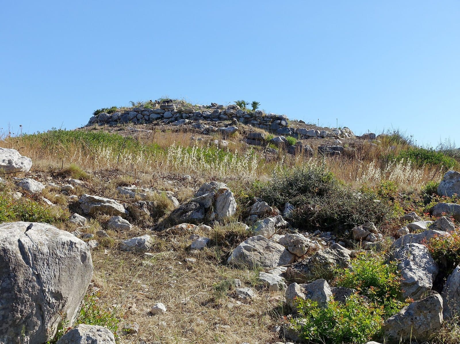

Between the beach resorts and small harbors of northeastern Mallorca, the talaiot de Mestre Ramon is a reminder that this coast was inhabited long before hotels, promenades, and fishing boats appeared. The archaeological site lies near Cala Bona in the municipality of Son Servera and preserves the remains of a prehistoric structure dated to the period after 1000 BC.
Its appeal does not lie in a reconstructed setting. Mestre Ramon is an excavation site where the surviving structural remains and the hillside location must tell the story themselves. That is precisely why it is worthwhile for anyone who wants to discover Mallorca’s history beyond museum displays. Among the stones and landforms, visitors can understand how closely monumental architecture was once connected to its surroundings.
Instead, it suits a quiet exploration of the area around Cala Bona, Port Nou, and Son Servera. Those who learn about the Talayotic culture beforehand will discover more; those arriving without prior knowledge will gain an immediate first impression of an era that profoundly shaped Mallorca’s landscape.
Mestre Ramon is also a place where restraint is appropriate. Researchers continue to debate the precise use of such structures. What is visible on site can therefore be observed and compared, but definitive stories about watchtowers, fortresses, or ritual sites would be more speculation than established knowledge.
History and significance
After 1000 BC, a structure was built on this hillside that is now known as the talaiot de Mestre Ramon. It therefore belongs to Mallorca’s prehistoric cultural development, which took its name from the talaiots: massive, tower-like monuments that rank among the most striking remains left by the communities of that period on Mallorca and Menorca.
The Talayotic culture
The broader historical setting reaches further back than Mestre Ramon itself. Around 1300 BC, settlement patterns and architecture on Mallorca changed significantly. Monumental stone buildings became prominent focal points in the landscape, while fortified settlements and communal spaces revealed a new social structure. The Talayotic culture lasted until the Roman conquest of Mallorca in 123 BC; however, this does not mean that every individual monument was used in the same way throughout that entire period.
For Mestre Ramon, the dating to the period after 1000 BC is crucial. The site therefore does not belong to the beginning of this development, but to a time when talaiots were already an established feature of Mallorca’s settlement landscape. This makes the site particularly interesting in its wider context: it is not an isolated stone mystery but part of an island-wide network of prehistoric monuments.
A structure with an uncertain function
The name talaiot derives from “talaia,” the word for a watchtower or observation tower. However, this later term must not be understood as a confirmed explanation of its original use. Proposed functions for talaiots include communal gatherings, the processing and distribution of food, representative purposes, defense, and the visual control of an area. None of these interpretations can be applied universally to every site.
At Mestre Ramon, the hillside location should likewise not be taken too quickly as proof of a military watch post. Recent archaeological studies of the Talayotic period emphasize that location and architecture could work together to create a strong visual presence. Such structures were not merely places from which people could see; they could themselves serve as widely visible symbols of a community. Whether this was the principal function of Mestre Ramon remains uncertain, but its position in the terrain helps visitors understand this research question in a tangible way.
From monument to archaeological site
No fully preserved prehistoric tower stands here today. The term “archaeological site” is important because it describes the character of the place more accurately: what survives and remains visible are structural remains whose relationships are interpreted through archaeological study. Visitors must read basic forms, stone arrangements, and terrain instead of following a completed reconstruction.
This is precisely where the significance of Mestre Ramon lies. The site shows not only a result but also the limits of knowledge. Archaeology works with surviving structures, their location, and comparisons with other sites. Where written sources are absent, several interpretations remain possible. A visit therefore does not lead to a single dramatic story, but to a more attentive view of prehistoric Mallorca.
What to see
The terrain is the first thing that stands out. The structural remains lie on the southern side of a hill, meaning that the monument cannot be considered separately from its surroundings. The slope forms part of the archaeological evidence: the choice of location influenced how the structure was perceived and how it related to the surrounding landscape.
The southern side of the hill
From the southern side, the site reveals itself as a combination of topography and architecture. Unlike a museum object, it offers no neutral view from every direction. The terrain guides the eye, places individual remains higher or lower, and makes clear that prehistoric builders worked with a specific location.
When viewing the site, it is worth resisting the urge to search immediately for the complete outline of a tower. A more revealing question is how the surviving sections sit within the slope and from which points they stand out most clearly. Studies of Talayotic architecture show that its visual effect resulted from both structural form and the choice of location. Mestre Ramon offers an opportunity to observe this interaction without elaborate staging.
The excavated structural remains
The remains of the prehistoric structure form the heart of the site. They make Mestre Ramon an excavation site and distinguish it from a place where only individual objects were found. Even so, visitors should not expect a completely reconstructed complex with enclosed rooms, towering floors, or recreated furnishings. The surviving evidence requires slow and attentive observation.
The visible structural remains are best read as traces of what was once a monumental whole. Individual sections may initially appear unremarkable, but they gain significance when their alignment with one another and their position in the terrain are considered. Nothing identifiable as an archaeological structure should be moved or stepped on. The scientific value lies not in the individual stone but in its position within the overall remains.
The talaiot as a landscape marker
Talaiots are often described as towers, but their impact probably extended beyond their use as practical observation platforms. These massive structures may have served as meeting places and visible symbols of social order. A scientific study of the Mallorcan Iron Age highlights that such architecture may have been designed both to provide a view and to be seen itself.
At the talaiot de Mestre Ramon, the hillside location makes this idea tangible. The site encourages visitors to shift their gaze between the ruin and its surroundings. Anyone looking only for a spectacular individual feature may overlook its most important characteristic: the monument was part of a designed landscape. Its effect arose not only from stone, but also from position, approach, and visibility.
Archaeology without a finished narrative
Nor should every massive remain automatically be attributed to a defensive structure. Several uses are conceivable for talaiots, and only a few monuments have been investigated comprehensively enough for their history to be told without gaps.
This makes the visit more demanding, but not less rewarding. Mestre Ramon shows how archaeological knowledge develops: from structural remains, spatial relationships, and comparisons. A photograph of the entire hillside may therefore be more informative than a close-up of an individual stone. From a short distance, the proportions of the site and its relationship to the change in terrain become easier to understand.
Visiting the site
Visitors who first survey the entire site and then examine individual positions again are more likely to recognize which remains belong together and how strongly the slope alters their perception. Mestre Ramon rewards attention more than speed.
Preparation and time needed
It is difficult to suggest a meaningful fixed duration for a visit to this site. Visitors interested in archaeology will stay longer because the structural remains become understandable only in relation to the topography.
A brief introduction to the Talayotic culture is helpful. The crucial distinction is between confirmed evidence and possible interpretation: the prehistoric origin, the dating to the period after 1000 BC, the structural remains, and the location on the southern side of the hill are documented. A communal space, defense, food distribution, or territorial visibility, by contrast, are general interpretive models for talaiots and not conclusively proven descriptions of Mestre Ramon’s function.
Light and viewing direction
It makes sense to visit at a time of day when the contours and terrain are clearly visible. Because no reliable visitor statistics or typical peak times have been published for Mestre Ramon, it is impossible to promise a dependable crowd-free period. Anyone seeking peace and quiet should not rely on generic insider advice about visiting times, but should allow enough time for a second look.
Photographs are particularly informative when they include not only the stones but also the hillside setting. A position slightly removed from the immediate remains often explains the site better than a tightly framed detail shot. Individual structural remains can then be examined more closely without stepping on or altering the archaeological structures.
Check access in advance
Opening hours and admission details are not reliably documented. Before traveling, visitors should therefore check whether the site is currently accessible and whether any special rules apply.
Getting there and parking
Long-distance routes initially lead to Cala Bona. From Palma Airport, the road distance to the coastal resort is 72 kilometers; the journey takes around 63 minutes via the Ma-15 and then the Ma-4030. From central Palma, the distance along the same sequence of roads is 74 kilometers, with around 69 minutes required for the journey.
The final section to the site
These distances and journey times end in Cala Bona, not directly at the archaeological remains. For the final section to the talaiot de Mestre Ramon, the exact location of the site should therefore be entered separately into the navigation system. The excavation site is not a conspicuous large structure on the promenade, but lies on a hill in the area around Son Servera.
Reaching the area by bus
The Port Nou and Sa Marjal stops serve the coastal area north of Cala Bona. However, they do not replace the need to plan the final section to the site. Before traveling, visitors should therefore check the current bus service, the appropriate stop, and the subsequent walking route together. Anyone who travels only as far as Cala Bona and then spontaneously searches for a prominently signposted monument could easily miss this understated archaeological site.
Bus lines to talaiot de Mestre Ramon at a glance
| Line | Route | Departures/day | First | Last |
|---|---|---|---|---|
| 412 | Costa dels Pins - Manacor | 124 | 05:35 | 23:00 |
| A42 | Cala Bona - Aeroport | 84 | 00:40 | 23:40 |
| 425 | Cala Bona - Portocristo | 41 | 07:38 | 22:40 |
From the official GTFS feeds (TIB/SFM), no real-time data. The figures cover all stops in the town; weekend and holiday services differ — check with the operator before travelling.
Getting there by bus
Port Nou 2 (62027) · 0.8 km as the crow flies
- 412Costa dels Pins - Manacor · Daily
Port Nou 1 (62026) · 0.8 km as the crow flies
- 412Costa dels Pins - Manacor · Daily
Sa Marjal 1 (62017) · 1.1 km as the crow flies
- 412Costa dels Pins - Manacor · Daily
Sa Marjal 2 (62018) · 1.1 km as the crow flies
- 412Costa dels Pins - Manacor · Daily
Cala Bona nord 1 (62028) · 1.5 km as the crow flies
- 412Costa dels Pins - Manacor · Daily
- 425Cala Bona - Portocristo · Daily
- A42Cala Bona - Aeroport · Daily
Cala Bona nord 2 (62029) · 1.5 km as the crow flies
- 412Costa dels Pins - Manacor · Daily
Costa dels Pins (62019) · 2.0 km as the crow flies
- 412Costa dels Pins - Manacor · Daily
Timetable data: official GTFS feeds (TIB/EMT), no real-time — check with the operator before travelling.
Nearby attractions
After the quiet structural remains, the route returns to a much younger coastal landscape. Cala Bona developed from a small fishing village whose life centered on the harbor. Fishing boats and traditional llaüts still give the harbor a different character from the island’s large tourist marinas.
Cala Bona and the harbor
The harbor is an easy place to end the archaeological excursion. Restaurants, bars, and shops line the jetties and waterfront, making it simple to combine a visit to Mestre Ramon with a break by the sea. The contrast is appealing: the hill preserves traces of a period without written records that are difficult to interpret, while the harbor reveals the town’s more recent maritime history almost by itself.
Cala Bona’s beach consists of three smaller sections separated by stone breakwaters. This gives the coast a clearly divided and manageable character. Combining the archaeological site with time at the beach creates a varied day without having to leave the area around Cala Bona and the Bay of Son Servera.
Port Nou, Port Vell, and Costa dels Pins
North of Cala Bona lie Port Nou, Port Vell, and the Costa dels Pins. These coastal communities are smaller and quieter than neighboring Cala Millor. They are suitable for continuing a drive along the bay without turning it into an extensive sightseeing itinerary.
For the archaeological context, however, Son Servera remains the essential reference point. Mestre Ramon is not part of a modern theme park but a prehistoric trace within a landscape that was repeatedly reshaped by agriculture, village life, and tourism in later periods. Its connection with Cala Bona makes particularly clear how many layers of time meet within a small area.
Local insider tips
Read the hillside first
Do not immediately focus only on individual stones. From a short distance, it is easier to see how the structural remains sit on the southern side of the hill and how location and architecture worked together.
Include the terrain in photos
A photograph of the entire hillside explains Mestre Ramon better than tightly framed detail shots alone. Close-ups of the visible structural remains and their alignment with one another are worthwhile afterward.
Combine it with the harbor
After visiting the site, head to the harbor of Cala Bona. Traditional llaüts can still be seen there, while restaurants and bars make it easy to combine archaeology with a coastal break.
Check the exact destination separately
The stated long-distance routes lead only as far as Cala Bona. For the final section, use the exact location of the site and check current access conditions in advance.