
Talaiot del Puig Figuer – Prehistoric Site near Artà
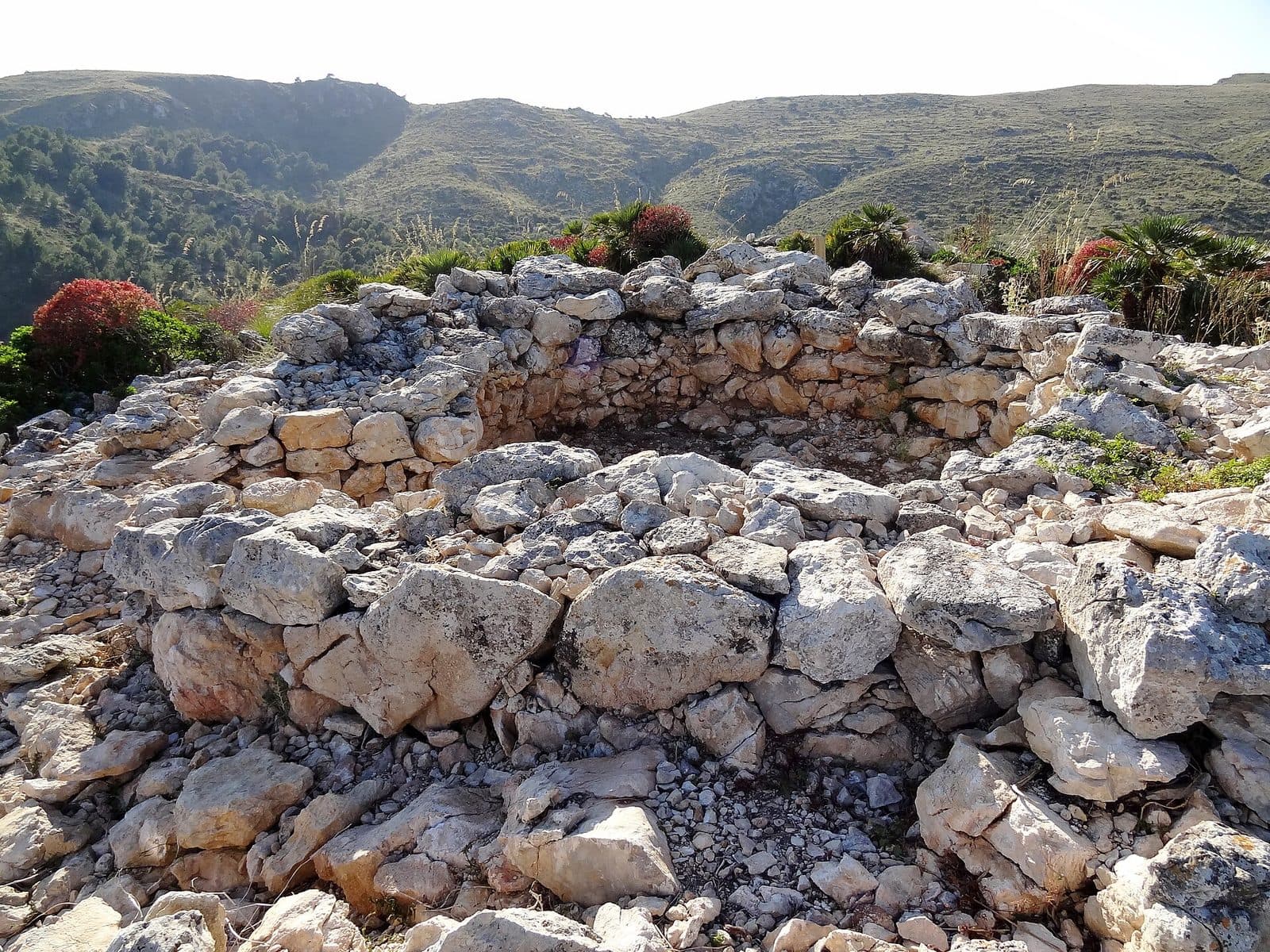

Talaiot del Puig Figuer stands on Puig Figuer in the mountains north of Artà. The lower section of a prehistoric round tower has survived. This pared-back form is precisely what makes the site so appealing: visitors must read the layout, entrance, and setting among the stones rather than follow a fully explained reconstruction.
The visit is aimed primarily at people who enjoy combining archaeology with a hike. Anyone expecting a fully excavated settlement will instead encounter an unexcavated mountain site. At Puig Figuer, the focus is on the direct relationship between the structure and the terrain: a massive body of stone, its south-facing entrance, and the question of why a community chose this particular location.
The site lies within the municipality of Artà, in Parc Natural de la Península de Llevant above the estates of s’Alqueria Vella and Son Morei. Reeds, dwarf palms, and the wildlife of the nature park form its present-day setting. Peregrine falcons, sparrowhawks, and Mediterranean tortoises are among the animals found in the area, although such wildlife naturally cannot be expected on every visit.
The site reveals its strengths slowly. At first, the low stretches of wall look like part of the rocky hillside. Only by walking around them do the curve of the tower, the opening to the south, and other nearby structures become apparent. Talaiot del Puig Figuer is therefore less a quick photo stop than a destination for attentive visitors who want to interpret a piece of prehistoric landscape from the few surviving architectural elements.
History and Significance
Built after 850 BC
Talaiot del Puig Figuer was built after 850 BC and therefore belongs to Mallorca’s Talaiotic period. During this era, monumental tower-like stone structures transformed the appearance of the island. Their builders had neither modern lifting equipment nor mortar, instead assembling large stone blocks into massive walls. The effort involved was considerable and suggests that these were not merely incidental utilitarian buildings but structures of communal importance.
The name “Talaiot” is associated with the Catalan word “talaia,” meaning a watchtower or lookout point. This long led to the assumption that the towers were built primarily for observation and defense. Archaeological research now presents a more cautious picture: talaiots are also understood as communal gathering places, while ceremonial, territorial, or representative purposes may have played a role depending on the site and period. No single function can be applied to every structure.
A Visible Landmark in the Landscape
The choice of location is particularly important at Puig Figuer. The tower stands on high ground above s’Alqueria Vella and Son Morei, making it part of a landscape visible from afar. Recent research into Mallorca’s talaiots emphasizes how location and architecture worked together: the structures not only offered views but were apparently also intended to be seen. Their massive outlines could make a community’s presence and territorial claim visible.
The south-facing entrance has been interpreted as a possible indication of a connection with a settlement in the valley. This interpretation is not certain, but it draws attention to an essential point: the talaiot was probably not isolated. Although the tower and several surrounding structures are the main features visible today, it was likely connected to a larger built environment.
A Protected, Unexcavated Archaeological Site
The archaeological site has not yet been fully excavated, so reconstruction drawings are based on the data obtained to date. Its present condition is both a limitation and part of its special appeal: it shows how a prehistoric monument can merge with the terrain over centuries while remaining legible.
The site has been protected as a cultural asset since 10 September 1966. This status underscores its historical significance but does not replace excavation. Whatever may remain beneath the ground is part of the site’s archaeological potential. Visitors should therefore not regard it as a collection of loose stones but as a sensitive monument whose seemingly inconspicuous layers may preserve scientific information.
What to See
The Round Tower Structure
The circular layout of the talaiot is its clearest surviving feature. The lower section of the original tower remains, with the walls now standing barely 1.5 meters high. Anyone expecting a complete, soaring watchtower may initially underestimate the site. Its defining impression comes not from height but from mass: broad courses of stone trace a compact circular structure whose full extent becomes apparent when walking slowly around it.
Seen up close, the irregular blocks reveal how different this building technique was from a modern wall laid with precise masonry. The stones were assembled without mortar. It is therefore best to view the continuous curve as a whole before examining individual joints and courses of stone.
The Entrance on the South Side
An important detail lies on the south side, where the entrance to the talaiot can be identified. This opening is more than a break in the wall. It gives the structure a clear orientation and helps distinguish its front from its rear. From here, visitors can imagine how the entrance once led into the massive body of the tower.
The southern orientation has been linked to a possible settlement in the valley. Whether the entrance was deliberately aligned with this settlement has not been conclusively established. Even so, the observation remains revealing on site: looking through the opening toward the valley demonstrates how entrances in prehistoric architecture may have been oriented not only for practical purposes but also in social and landscape terms.
The Surrounding Wall Remains
Further stretches of wall lie around the talaiot. They are lower and less continuous than the tower structure, so they can easily be overlooked among the ground, stones, and vegetation. Yet these remains show that the site should not be reduced to a single round building. The talaiot was apparently part of an architectural complex whose complete layout cannot yet be reconstructed with certainty because it has not been excavated.
When examining the remains, it is worth looking for lines: where do several stones form a shared alignment, where does a wall change direction, and where does a structure merge into the natural terrain? A reconstruction of the complex presents possible connections between these walls, but it remains expressly an approximation. The actual remains on site are more fragmented and demand more patience than an excavated archaeological park.
The Square Structure
A square structure has also been documented near the round tower. It forms a striking geometric contrast with the circular main building. Its precise function is unknown, so it should not be hastily described as a dwelling, sanctuary, or outbuilding. The fact that different ground plans occur side by side at the site is already archaeologically significant.
The square is one of the details most easily missed during a quick visit. It helps to look beyond the prominent round structure and systematically examine the immediate surroundings. Only then does the site begin to appear as an ensemble. The different structures suggest that more took place here than the low remains of the tower alone reveal today.
Puig Figuer as Part of the Monument
The location is inseparable from the architecture. Puig Figuer rises above the lands of s’Alqueria Vella and Son Morei in the nature park on the Llevant peninsula. From an archaeological perspective, this setting is not merely a decorative backdrop. It determined what could be surveyed from the structure and from which areas the tower itself could be seen.
Viewing the talaiot from different directions reveals this interaction particularly clearly. Up close, the rough masonry dominates; from a little farther away, the round structure becomes part of the contours of the terrain. This precise relationship is also central to research into Talaiotic architecture: monuments could stand out through their form while simultaneously enhancing the natural visibility of high ground. At Puig Figuer, this idea can be understood directly, without a museum display case.
Visiting Talaiot del Puig Figuer
Exploring the Archaeological Remains
The first glance does not reveal the entire site. The best approach is to walk slowly around the talaiot. Its circular outer line, southern entrance, lower wall remains, and square structure emerge one after another. This kind of circuit feels more like reading archaeological evidence than visiting a restored monument: stones, edges of the terrain, and vegetation must be distinguished from one another.
Because the site has not been fully excavated, the remains are fragmented. Visitors with an interest in history may see this as an advantage, since the site encourages close observation and a distinction between established evidence and possible reconstruction. It is less suitable, however, for an unprepared, spontaneous stop.
A Hiking Destination
The talaiot lies in the mountains of Artà and is best planned as a hiking destination in Parc Natural de la Península de Llevant. Some published hiking routes combine Puig Figuer with other peaks such as Puig des Corb, Puig des Porrassar, and Talaia Freda. Such an extended combination is not necessary simply to visit the talaiot, but it demonstrates that the site belongs to a hiking area rather than an urban sightseeing circuit.
The length of the excursion therefore depends primarily on the chosen starting point and route through the nature park. Enough time should be reserved at the archaeological site to view the tower and its secondary structures several times from different angles. A standard short visiting time would be misleading because the route can account for the larger part of the excursion.
Planning Before You Set Out
No confirmed opening hours or admission information are recorded. Because access rules in a protected area can change, current information should be checked before setting out. This is particularly important if the talaiot is to be included in a longer hike. The nature park is not recreational terrain that can be accessed at will; official routes and any temporary notices take priority.
There is also no reliably documented time of day when visitor numbers are particularly low. The timing should therefore be based more on weather, daylight, and the length of the hiking route than on expectations about crowds. The talaiot itself is a quiet, understated destination, but conditions and visitor frequency on the nature park’s trails may vary by season.
Getting There and Parking
From Palma and the Airport to Artà
The reliable driving information applies to Artà, not to the talaiot in the mountains above it. From Palma Airport, the route follows the Ma-15. Artà is 71 road kilometers away, and the drive takes around 59 minutes. From central Palma, the route also follows the Ma-15. This journey covers 74 road kilometers and takes around 66 minutes.
Artà is therefore the initial destination by road. From there, the transition to the hiking area of Parc Natural de la Península de Llevant must be planned separately. The recorded address is Artà, Mallorca. Because the talaiot stands on Puig Figuer above s’Alqueria Vella and Son Morei, visitors must use the nature park’s current access points and trails for navigation.
The Final Section to the Site
For the final section, consult an up-to-date hiking map or the protected area’s official trail information. Several published routes lead to the talaiot or include Puig Figuer in longer mountain hikes. Bear in mind that a route taking in additional peaks requires a different level of time and fitness than a direct walk to the archaeological site.
No bus stop is recorded in the immediate vicinity of the site. Traveling exclusively by scheduled bus therefore does not cover the final section; the actual approach remains a hike. The distance from the place where the car is left to the talaiot should be treated as part of the excursion, not as a short walk across a visitor complex.
Navigate by Location, Not Just by Name
The complete name is important when navigating. The destination is the archaeological Talaiot del Puig Figuer within the municipality of Artà, not another place with a similar-sounding name. Puig Figuer itself and the neighboring lands of s’Alqueria Vella and Son Morei provide additional orientation.
Checking the route carefully before setting out prevents a circular trail designed for mountain hikers from being mistaken for a short access path. Road navigation and hiking-route planning are two separate stages here: the Ma-15 leads to Artà, after which the nature park’s access points and the chosen route determine the remainder of the journey.
Nearby Places to Visit
Artà
Artà is the natural base for exploring northeastern Mallorca. The town lies between the island’s interior and the mountains of the Llevant peninsula. After a hike to Puig Figuer, a walk through its historic center is a good option. This adds more recent layers of the island’s history to the landscape experience without requiring another major hiking destination on the same day. For travelers arriving from Palma or the airport, Artà is also the logical point of reference because the stated road distances end there.
Ses Païsses
Visitors wishing to understand Talaiot del Puig Figuer in a broader archaeological context can combine the excursion with Ses Païsses near Artà. A more extensive Talaiotic settlement survives there, including a central round talaiot, additional buildings, and a massive enclosing wall. The comparison helps illustrate how differently prehistoric sites can survive.
Ses Païsses should not be regarded as a substitute for Puig Figuer. The settlement presents architecture within a more clearly legible overall context, whereas the talaiot on the hill demonstrates the relationship between a monument and the open landscape particularly vividly. The two sites answer different questions and complement each other primarily through the contrast between a distinct settlement layout and an unexcavated mountain site.
Parc Natural de la Península de Llevant
The nature park forms the landscape setting of the talaiot. Reeds and dwarf palms characterize parts of the vegetation, while its wildlife includes peregrine falcons, sparrowhawks, and Mediterranean tortoises. These details do not guarantee a sighting, but they serve as a reminder that the route crosses not only an archaeological area but also an ecologically protected landscape.
Longer routes can connect Puig Figuer with Puig des Corb, Puig des Porrassar, or Talaia Freda. Such combinations are intended for hikers who want to explore a larger section of the mountains. For an excursion focused on archaeology, it makes more sense to allow enough time at the talaiot rather than trying to fit as many peaks and names as possible into a single tour.
More Places in Northeastern Mallorca
Depending on the day’s schedule, the center of Artà, the Sant Salvador sanctuary, or the Caves of Artà can be added as separate destinations. They should be planned separately from an extended hike. A visit to Puig Figuer benefits from calm and close observation; a tightly scheduled itinerary deprives the site of precisely the quality that distinguishes it from more developed attractions.
The place it belongs to
Artà in the place guidePractical Information
Equipment for a Hiking Destination
The talaiot stands on high ground in a nature park and is reached via hiking trails. Suitable footwear, drinking water, and weather-appropriate equipment should therefore be part of the preparation. The requirements are determined not only by the few steps around the monument but by the entire chosen route there and back. Particularly when combined with other peaks, the hike may substantially outweigh the actual visit to the monument.
An up-to-date map should not be opened for the first time after setting out. The name of the site alone does not indicate which access point is appropriate for the planned route. By deciding on the route, available daylight, and return journey in advance, visitors can focus on the archaeological details once they reach the talaiot.
Respect the Site and Nature Park
Low wall remains are more fragile than their rough blocks suggest. Stones must neither be moved nor stacked into small towers. Even a seemingly loose block may be part of the archaeological evidence. The same applies to the less conspicuous walls around the round structure and to the square structure.
Protecting the nature park requires the same restraint. Staying on designated trails, avoiding disturbance to animals, and leaving nothing behind help preserve both the landscape and the archaeological site. Mediterranean tortoises and birds of prey are part of the habitat, not attractions to be followed away from the route.
Visiting with Children
Children may find the talaiot exciting if the excursion is presented as a shared search for clues: Where does the curve begin, where is the entrance, and which wall forms a square? This makes fragmented archaeological evidence easier to understand than a lengthy historical explanation. The crucial consideration, however, is whether the chosen hiking route suits the children’s age, stamina, and experience.
It should be clear on site that the walls are not for climbing. The talaiot is a protected archaeological monument, and the surrounding structures can be difficult to distinguish among the vegetation and natural rock. Families therefore need more attention and time than they would at a fenced museum site.
What Not to Expect
Talaiot del Puig Figuer is not a reconstructed tower complex but a low, unexcavated, and fragmentarily preserved site. The surviving remains consist of the circular substructure with its southern entrance and additional wall remains nearby.
That is precisely what makes it distinctive. The visit does not present a finished story but archaeological evidence within its landscape. Anyone prepared to search for shapes, examine sightlines, and accept uncertainty will gain a vivid impression of how monumental even a structure surviving only to a low height today may once have appeared in the prehistoric landscape.
Local insider tips
Find the South Side First
The talaiot’s entrance lies on the south side. This is not only the best place to identify the opening into the round structure; the view toward the valley also illustrates its presumed relationship with a former settlement below Puig Figuer.
Do Not Miss the Square
Attention often remains fixed on the round tower structure. A square structure also lies nearby, however. It is an important indication that the archaeological site included more than a single tower.
Explore the Site, Not Just the View
The talaiot is a hiking destination in Parc Natural de la Península de Llevant. It is best understood by walking all the way around the tower and then examining the low wall lines in its surroundings.
Compare It with Ses Païsses
To see two different forms of Talaiotic preservation, combine Puig Figuer with Ses Païsses near Artà: here an unexcavated mountain site, there a more extensive settlement complex whose layout is easier to read.
Pay Attention to the Landscape
Reeds, dwarf palms, and the wildlife of the nature park form part of the present-day setting. Peregrine falcons, sparrowhawks, and Mediterranean tortoises live in the area but should be observed only from a distance and without leaving the trails.