
Pont Romà in Pollença: Mallorca’s Mysterious Stone Bridge
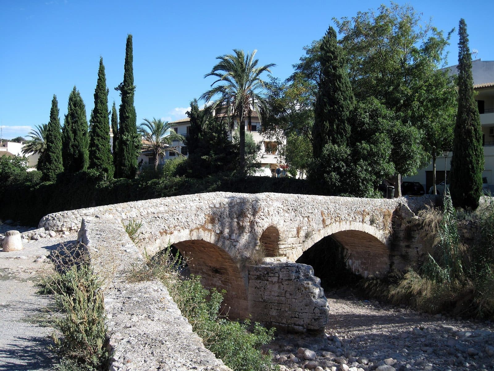

At the edge of the old town, Pont Romà spans the Torrent de Sant Jordi. This squat stone bridge is not one of those sights designed to impress with its size or lavish decoration. Its appeal lies in its clarity: two arches, an old crossing and a name that promises more than historical sources have so far been able to confirm with certainty. It is precisely this mystery that makes Pont Romà a worthwhile destination. It has been called the “Roman Bridge” since the 19th century, yet written evidence of the structure dates back only to the Middle Ages. Anyone standing here is therefore not simply looking at a supposed relic from antiquity, but at a place where tradition, local history and visible architectural form overlap.
A visit fits particularly well into a walking tour of Pollença. The bridge is not secluded within an archaeological site but stands at a historic entrance to the town. It can be viewed deliberately as a monument in its own right or used as the starting point for a walk through the lanes, squares and other historic sites of the old town. For travelers interested in architectural history, Pont Romà is especially fascinating because it offers no simple answer. Families can use its arches to explain clearly why bridges were vital to towns in earlier times. Hikers, meanwhile, encounter a crossing closely connected to the old routes around Pollença.
History and significance
The famous name is younger than the bridge. The crossing has been known as Pont Romà only since the 19th century. The earliest confirmed written reference, by contrast, dates from 1403, when it appeared under the name “Puente de Cubelles.” The core of its historical mystery lies between these two names: Was this really a Roman structure, or was a medieval bridge later considered Roman because of its age and appearance?
The Roman interpretation
The broader historical context initially supports the possibility of an ancient origin. The Romans were present on Mallorca from 123 BC to 425 AD. In the area of present-day Alcúdia, they founded Pollentia, an important Roman city. One traditional interpretation sees Pont Romà as part of an aqueduct or a route leading toward Pollentia.
This explanation is appealing but unproven. The present town of Pollença has been documented at its current location only since the 13th century. There is therefore a substantial chronological gap between the Roman era, the medieval settlement and the bridge’s first recorded mention, meaning that its name alone cannot establish an ancient construction date.
Puente de Cubelles
The evidence becomes considerably firmer from 1403 onward. The name “Puente de Cubelles” refers to the landscape and routes outside the gates of Pollença. Residents used the crossing to reach Horta de Cubelles. The bridge was therefore not an isolated monument but part of everyday travel between the town, agricultural land and the surrounding routes.
Until the 19th century, it was regarded as the only safe way to cross the Torrent de Sant Jordi at this point. This practical purpose explains its importance better than any romantic legend: Pont Romà connected two banks, secured routes and allowed residents to cross the watercourse even when a simple ford became difficult to use.
From transport route to monument
Today, Pont Romà is protected as a historic-artistic monument. At the same time, it is still perceived as a crossing over the Torrent de Sant Jordi. Its history is therefore not confined to a vanished era, because the structure’s original purpose remains immediately legible.
The unresolved question of its date demands a particularly careful look. The bridge should be presented neither hastily as definitively Roman nor exclusively as medieval. What is documented is its medieval name, its centuries-long function and the Roman attribution used since the 19th century. This makes it a good example of how historical places acquire meaning not only through phases of construction but also through later names and narratives.
What to see
Two rounded stone arches carry the crossing over the Torrent de Sant Jordi. Pont Romà needs nothing more to make its purpose understandable. The structure appears robust and practical; ornamentation and prestigious façades are not its focus. Anyone who merely crosses the bridge, however, will barely grasp its form. Only the view from the side reveals how the arches open up the structure and allow the watercourse to pass beneath it.
The two rounded arches
The two semicircular openings define the bridge’s appearance. Their curves are also the feature that has encouraged the popular idea of a Roman bridge. Rounded arches alone, however, do not permit a reliable date, as this form continued to be used long after antiquity. The site therefore offers a particularly clear way to understand why the structure appears Roman and why historians nevertheless remain cautious about this attribution.
The structure is best viewed from more than just the front. From the side, the relationship between the massive stone sections and the open arches becomes clear. From this perspective, an inconspicuous crossing turns into a clearly organized structure: the path above, the torrent’s passages below and the load-bearing stonework between them.
The stonework
The visible surface consists of stone, giving the bridge its heavy, almost archaic character. The material connects it visually with many historic buildings in Pollença, although this does not automatically mean that they were built during the same period. The interest lies less in individual decorative details than in the way the entire structure is designed for durability and strength.
Up close, the irregularities in the masonry stand out more clearly than they do in an overall view. Light and shadow trace the joints and edges, while the curves of the arches appear more unified from farther away. Pont Romà therefore rewards two approaches: a close look at the stone and a more distant view of the bridge’s complete form.
Torrent de Sant Jordi
The watercourse is not merely a backdrop but the reason the bridge exists. Without the Torrent de Sant Jordi, Pont Romà would be only an old section of road; with it, the crossing’s historical purpose becomes clear. The water level can change the site’s appearance, but its essential spatial arrangement always remains the same: the bridge leads from one bank to the other and keeps the route above the streambed.
The historical reference to the only safe crossing until the 19th century also becomes tangible here. Looking beneath the arches makes it easier to appreciate why a reliable bridge mattered more to residents than its representative impact. It did not merely shorten a route but made an everyday connection more dependable.
The crossing into town
Pont Romà stands on Carrer del Pont Romà at the edge of historic Pollença. It therefore appears as a threshold between the routes outside the old town center and the town itself. This location corresponds with its traditional function as a link to Horta de Cubelles.
The masonry is therefore not the only feature worth seeing, as the direction of the route also forms part of the visitor experience. On one side lies the entrance to Pollença; on the other, routes open out into the surrounding area. Anyone who crosses the bridge in both directions experiences it not merely as a photo subject but in the function that shaped its history.
Visiting Pont Romà
A visit is best begun not by asking how old the bridge might be, but by making a complete circuit of the visible structure. First, it is worth viewing both arches from the side, then walking across Pont Romà itself. Looking back reveals how closely the structure is connected with the entrance to the old town.
The short bridge walk
A brief stop is sufficient for the bridge alone. Anyone who merely walks across and takes a souvenir photo, however, will miss the most interesting part. A slow change of perspective reveals more: the overall view, masonry, arches, streambed and finally the route across the bridge. As there are no interiors or exhibitions to explore, the length of the visit depends on how closely you look.
A historical walk becomes more rewarding when the name “Pont Romà” is not treated as a complete explanation. In front of the arches, the tradition can be compared with the confirmed key facts: the first reference as Puente de Cubelles, the later name Roman Bridge and the construction date that remains unresolved. The visible structure stays the same, but the way it is viewed becomes more nuanced.
Light and viewing direction
The sculptural effect of the masonry depends on the light. When light falls across the stones from the side, the joints, edges and curves of the arches stand out more clearly. Even light, by contrast, works well for an overall photograph in which both openings and the course of the crossing remain easy to read.
No particular time can reliably be identified as the quietest time to visit. Pont Romà is not located inside an enclosed museum but on a working crossing at the edge of town. Anyone wishing to look around undisturbed should allow some flexibility and, if necessary, wait briefly for the path to clear. Because the structure is compact, even a small change in viewpoint can significantly alter the impression.
A starting point for the old town
It is especially fitting to place Pont Romà at the beginning of a walking tour. Its historical function as an entrance then becomes tangible in practice: after viewing the arches, the route leads across the bridge toward Pollença. Conversely, it can provide a peaceful conclusion to an old town visit before returning to a parking area on the northern edge of town.
Current information about possible visitor restrictions should be checked before the trip, as the available visitor data contains neither fixed opening hours nor an admission charge. On site, however, the focus is not on following an organized exhibition route but on viewing the historic crossing and understanding how it fits into the public space.
Getting there and parking
Regional routes initially lead to Pollença, not directly to the bridge arches. This is important for planning: the stated distances and travel times end in the town. The final section leads to the northern edge of the old town and Carrer del Pont Romà, where the bridge spans the Torrent de Sant Jordi.
From Palma Airport
The road distance from Palma Airport to Pollença is 57 kilometers. The journey takes around 45 minutes and follows the Ma-30, then the Ma-13 and finally the Ma-2200. After arriving in Pollença, continue toward the northern edge of the old town. As road conditions and traffic arrangements on the final streets can change, navigation should be continued to Pont Romà or Carrer del Pont Romà.
The route along the Ma-13 covers most of the drive north, after which the Ma-2200 leads to Pollença. Anyone combining the visit with a walk through the old town does not need to bring the vehicle as close to the masonry as possible; a parking space on the edge of town, from which the bridge and center can be reached on foot, is more practical.
From Palma
From central Palma, the road distance to Pollença is 54 kilometers. The journey takes around 50 minutes and follows the Ma-13 and Ma-2200. These figures also apply only as far as Pollença. Within the town, the final section follows the local access route toward Pont Romà.
The small difference between the two routes results from their different connections to the main road network. For the bridge visit itself, the important factor is no longer the main road but finding the northern edge of the historic town center.
Parking on the northern edge of town
A larger parking area can be found near the Ma-10, level with Pont Romà on the northern edge of Pollença. It is particularly suitable when the bridge and old town are to be combined in one walk. From there, the final section to the historic crossing is completed on foot.
Parking availability may depend on the time of day and events taking place in town. Rather than searching for a space in the narrower streets of the old town, the edge of town usually offers a clearer starting point. Beginning the walk from outside toward the center also preserves the bridge’s original effect as an entrance to Pollença.
By bus
The Pont Romà 1 and Pont Romà 2 stops are close to the bridge. La Font 1 and La Font 2 are also located in the wider surrounding area. The most suitable service depends on the point of departure and the current timetable. After getting off, the short final section is completed on foot; Pont Romà and the northern edge of the old town provide useful orientation points.
Bus lines to Pont Romà at a glance
| Line | Route | Departures/day | First | Last |
|---|---|---|---|---|
| 322 | Pollença - Port d'Alcúdia | 753 | 00:06 | 23:40 |
| 301 | Port de Pollença - Palma | 133 | 06:15 | 22:38 |
| 321 | Cala de Sant Vicenç | 102 | 07:49 | 22:08 |
| 231 | Port de Sóller - Alcúdia | 12 | 10:38 | 20:21 |
From the official GTFS feeds (TIB/SFM), no real-time data. The figures cover all stops in the town; weekend and holiday services differ — check with the operator before travelling.
Getting there by bus
La Font 1 (42009) · 0.7 km as the crow flies
- 231Port de Sóller - Alcúdia · Daily
- 301Port de Pollença - Palma · Daily
- 321Cala de Sant Vicenç · Daily
- 322Pollença - Port d'Alcúdia · Daily
La Font 2 (42033) · 0.7 km as the crow flies
- 231Port de Sóller - Alcúdia · Daily
- 301Port de Pollença - Palma · Daily
- 321Cala de Sant Vicenç · Daily
- 322Pollença - Port d'Alcúdia · Daily
CEIP Joan Mas (42005) · 0.8 km as the crow flies
- 301Port de Pollença - Palma · Daily
- 321Cala de Sant Vicenç · Daily
- 322Pollença - Port d'Alcúdia · Daily
Poliesportiu (42004) · 0.8 km as the crow flies
- 301Port de Pollença - Palma · Daily
- 321Cala de Sant Vicenç · Daily
- 322Pollença - Port d'Alcúdia · Daily
Pollença 1 (42001) · 0.9 km as the crow flies
- 301Port de Pollença - Palma · Daily
Pollença 2 (42002) · 0.9 km as the crow flies
- 301Port de Pollença - Palma · Daily
- 321Cala de Sant Vicenç · Daily
- 322Pollença - Port d'Alcúdia · Daily
Polígon de Pollença 1 (42043) · 1.5 km as the crow flies
- 231Port de Sóller - Alcúdia · Daily
- 301Port de Pollença - Palma · Daily
- 321Cala de Sant Vicenç · Daily
- 322Pollença - Port d'Alcúdia · Daily
Timetable data: official GTFS feeds (TIB/EMT), no real-time — check with the operator before travelling.
Nearby sights
Crossing Pont Romà does not lead into an archaeological park but into Pollença itself. This is precisely what makes the bridge such a good starting point: a single historic crossing develops into a walk through a town whose streets, religious buildings and former monasteries bring together several chapters of Mallorcan history.
Pollença old town
The lanes of the old town continue toward Plaça Major, the town’s central meeting place. On Sundays, the weekly market draws additional visitors into the streets and square. Anyone visiting on that day can combine the bridge and market, but should also expect a busier center and greater demand for parking spaces.
Pont Romà provides an appropriate historical starting point for an old town walk. It is a reminder that towns consist not only of churches, mansions and squares but also of routes, watercourses and crossings. Its simple design creates an appealing contrast with the more prestigious sites in the center.
Calvari
One of Pollença’s best-known destinations is Calvari, with its 365 steps. At the top stands a chapel from the 18th century, which also preserves sculptures dating from 1448. The ascent is considerably more demanding than the short stop at the bridge and gives a walking tour a second, vertical focus.
Combining the two places tells the story of Pollença from two perspectives: Pont Romà represents crossing the torrent and entering the town, while Calvari represents the climb above the town’s rooftops. Enough energy should be reserved for the steps, especially on warm days.
Sant Domingo and Museu de Pollença
The former Dominican monastery now houses Museu de Pollença. Its collection and cloister offer a different emphasis from the bridge’s freely accessible exterior. Anyone seeking more historical and artistic context after Pont Romà will find it a logical continuation of the walk.
The Joan March gardens and medieval Torre Desbrull are also nearby. These destinations can be included in a town walk without turning the bridge visit into a lengthy standalone tour. Pont Romà remains the place where the history of transport and the landscape meet most directly.
Refugi del Pont Romà
Refugi del Pont Romà is located near the Torrent de Sant Jordi. The building formerly served as the municipal slaughterhouse and is now a hikers’ hostel. Its name refers directly to the neighboring bridge.
The location is particularly important for hikers because the Refugi is reached on the stage from Son Amer near Lluc to Pollença along Ruta de Pedra en Sec GR 221. Pont Romà thus once again becomes a waymarker: what once made access to Horta de Cubelles easier now also marks the transition between a long-distance hiking route and a visit to the town.
The place it belongs to
Pollença in the place guidePractical visitor information
Pont Romà is not a museum with a set route, ticket office and exhibition rooms. Instead, visitors should expect a compact historic structure in a public part of town. The real reward comes from looking closely and understanding the unresolved question of its date. Anyone searching only for an unquestionably ancient ruin may misunderstand the site.
Footwear and weather
As the visit takes place outdoors and is usually combined with a walk through Pollença, secure, comfortable shoes are advisable. This is especially true if Calvari and its steps are next on the itinerary. No hiking equipment is required for the bridge alone; continuing along GR 221 naturally involves different requirements.
Sun or rain protection should be selected according to the current weather. Pont Romà has no interior areas where a visit can be continued away from strong sunshine or rain. Anyone wishing to take photographs and examine the masonry in peace should therefore avoid planning too brief a stop.
Visiting with children
The bridge’s function is easy for children to understand: the path runs above and the torrent below. The two rounded arches show how a heavy stone structure can carry a route across a watercourse. The unresolved question of its age can also be more exciting than a definitive date, as families can consider together which clues point to a Roman or medieval origin.
Normal supervision is required near the streambed and on the crossing. Pont Romà is neither a playground nor a secured visitor attraction. The short length of the visit does, however, suit families, and the onward route into the old town can be adapted flexibly to stamina and interest.
Photography and observation
For an informative photograph, choose at least one side view showing both rounded arches and the torrent. A photograph taken only from the bridge’s surface may show the route but reveals little of the characteristic structure. Details of the masonry work best as additions to the overall view.
The most common mistake is to treat the name as proof of the bridge’s construction date. It is more accurate to describe Pont Romà as a historic stone bridge of uncertain origin. What is firmly documented is its mention in 1403 as Puente de Cubelles, its later name as the Roman Bridge and its centuries-long role as an important crossing over the Torrent de Sant Jordi.
Local insider tips
View it from the side first
Do not cross the bridge immediately. From the side, both rounded arches, the stonework and the Torrent de Sant Jordi can be seen together. Only this perspective explains the structure and provides the clearest overall view.
Remember the old name
The best talking point lies not in the name Pont Romà but in “Puente de Cubelles.” The bridge was first mentioned under this name in 1403; its actual construction date remains unresolved today.
Experience it as a town entrance
Begin the walk on the northern edge of town, view the arches and then cross Pont Romà into Pollença. This makes its historical function as a crossing and entrance to the town immediately understandable.
Where the bridge meets a long-distance trail
Refugi del Pont Romà is located near the bridge, a destination on GR 221 along the stage from Son Amer near Lluc to Pollença. For hikers, Pont Romà is therefore an ideal finishing point before a walk through the old town.
Photograph the arches, not just the path
For the most informative photograph, do not capture only the surface of the crossing. A side view showing both rounded arches reveals why the bridge received its Roman name—even though that date has not been confirmed.