
punta de sa Torre near Portopetro: Coastal Beacon and History
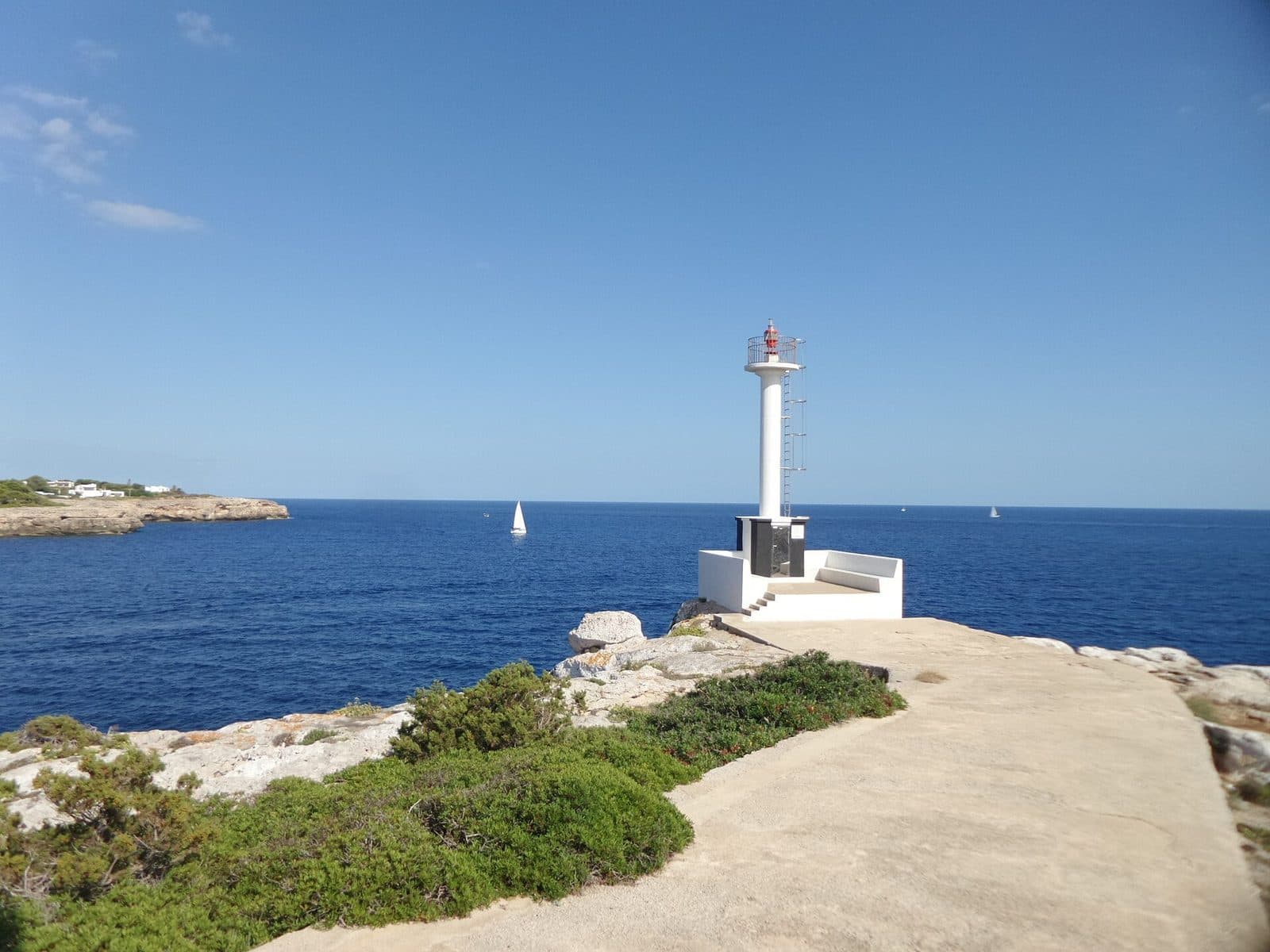

Two structures that are easily confused meet on the coast of Portopetro: punta de sa Torre, listed as a lighthouse, and the historic defensive tower of Portopetro. The present-day beacon is also known as Balisa de sa Punta de sa Torre and is a maritime landmark on Avinguda de la Torre.
It is precisely this modest scale that makes the stop interesting. In a compact area, the headland tells the story of two eras of coastal observation: in the past, a fortified tower was intended to warn of pirates and corsairs; today, a light helps vessels navigate at sea. Anyone looking only for a monumental lighthouse might overlook the character of the place. Those who want to understand Portopetro's coastal landscape and its history, however, will find an illuminating setting here.
The visit is especially suitable for travelers already exploring Portopetro, visiting the harbor, or planning a detour to Caló de sa Torre. The beacon alone does not require a long stay, but together with the old tower, views over the Mediterranean, and a walk through the coastal village, it makes for a varied short excursion.
A clear distinction is important: in this article, punta de sa Torre refers to the beacon on the headland near Portopetro. The historic Torre de Portopetro is part of the immediate historical setting, but it is not the same as the lighthouse. Nor does this article concern places with the same name near Llucmajor, on Ibiza, or at Punta de n’Amer.
History and significance
Even before Portopetro developed as a coastal settlement, the area had to be considered from the perspective of the sea. Attacks by pirates and corsairs shaped security planning along Mallorca's coasts for a long time. By 1584, eleven fortified towers already formed part of the island's defensive system; Torre de Portopetro was added several years later, at the beginning of the 17th century.
Predio Sa Punta
When the defensive tower was built, Portopetro did not yet exist as a village. The area was called Predio Sa Punta and belonged to the Danús family from Santanyí. The name refers to the projecting coastal position, which was suitable for monitoring the approach. The tower was therefore not originally the landmark of a harbor town, but an outpost in a sparsely populated coastal landscape.
Its purpose was to monitor the sea: the garrison was expected to spot suspicious ships early and warn of impending attacks. The names Avinguda de la Torre and Caló de sa Torre are documented in the surrounding area.
Torre de Portopetro
The historic tower is the reason many descriptions of the area refer to a Torre. It must not, however, be retrospectively described as a lighthouse. It is a fortified coastal structure from the early 17th century, whereas Balisa de sa Punta de sa Torre is a navigational light for shipping. They served different purposes: one structure watched for possible attackers, while the other marks the coast for maritime traffic.
This distinction is more than a matter of terminology because it reveals how people's relationship with the sea has changed. What was once viewed as a possible direction of attack later became a route identified by navigational markers. The headland remained a landmark even as its function changed.
The Archduke's drawing
An important visual record of the old tower comes from Archduke Ludwig Salvator of Austria, who extensively researched and described the Balearic Islands. His drawing of Torre de Portopetro appeared in 1897 in the first volume of “Die Balearen.” The image is especially valuable because it records the structure in an earlier condition.
In the drawing, the defensive tower appears taller than in later views; it may have had three stories at the time. Visitors to the headland can compare the tower as it looks today with this visual record from the 19th century.
What to see
Your first impression will depend heavily on what you expect. Anyone who imagines a lighthouse as a tall tower visible from afar, with a keeper's house, spiral staircase, and visitor terrace, will encounter a different type here. punta de sa Torre is listed as a Balisa—a navigational light at a prominent point on the coast. Its appeal lies less in monumental architecture than in its location and its relationship with the historic tower.
Balisa de sa Punta de sa Torre
The term Balisa helps classify the structure correctly. In Spanish usage, it refers to a nautical signal or beacon marking a coastal point or a location important to shipping. For this reason, punta de sa Torre should not be compared with Mallorca's large lighthouses, whose towers and outbuildings form complete complexes.
At the site, it is worth first considering the location: the navigational light stands on Avinguda de la Torre in the coastal area of Portopetro. Its significance becomes clear through its relationship with the sea. From there, it is easy to understand why this headland is recorded as a nautical reference point.
The beacon is not a conventional sightseeing building. The available information does not document an exhibition, publicly accessible interior rooms, or a platform that visitors can climb. The visit therefore focuses on viewing the coastal marker from outside and exploring its historical surroundings. Knowing this in advance prevents the most common disappointment.
Torre de Portopetro
The old defensive tower is the more historically significant architectural structure on the headland. Its form evokes an era when coastal towers were intended less for safe navigation than for issuing timely warnings. Its location provided views over the sea and the surrounding Portopetro area. The tower thus served as an observation post long before the present-day settlement developed.
A comparison with Ludwig Salvator's drawing, which shows the tower in a 19th-century depiction, is particularly revealing. Rather than searching only for a supposedly original state, it is worth paying attention to the proportions, the building's mass, and the tower's position above the coast.
Visitors should not assume that the interior is accessible. Older reports mention only rare opportunities to enter, and no reliable current visiting hours have been recorded. Viewing the ensemble from outside remains the reliably accessible part of the excursion.
Headland and sea views
The true experience emerges from the site's two functions. On one side stands the historic tower, from which the horizon was scanned for potential threats. On the other is the present-day navigational light, marking the same stretch of coast for shipping. The view of the Mediterranean connects the two.
This relationship is best understood when the location is treated as more than a photo opportunity. The open coastline, the approach to Portopetro, and the Punta's projecting position explain why both a watchtower and a nautical signal made sense here. The sea is therefore not merely a backdrop but the key to understanding the attraction.
Visiting punta de sa Torre
A stop at punta de sa Torre is best approached with the right expectations: no large lighthouse museum is documented here, but rather a compact coastal landmark. The beacon can be viewed from outside, after which the historic tower can be considered as the site's second layer. Visitors who distinguish between the two while also considering them together will gain more than they would from a quick photograph.
Walk around the Punta
A simple sequence works well for the visit. First, focus on the Balisa itself and its position in relation to the sea, then turn your attention to Torre de Portopetro. From there, it is possible to trace the development from a fortified observation post to a nautical coastal marker. A look toward the harbor and coastline completes the walk.
The basic visit is short because there is no documented permanent exhibition or regularly accessible lighthouse interior. It is worth allowing more time if you want to take photographs, examine the old tower, and walk through Portopetro. The destination is too small for a day trip on its own, but it works well as a deliberate stop on the southeast coast.
Access and visiting hours
Current opening hours have not been recorded. This is particularly important if you hope to see the interior of the historic Torre de Portopetro. Older references to occasional access are not a reliable basis for planning. Anyone specifically wishing to enter should therefore check the latest situation immediately before visiting.
No current admission price has been recorded either. This should not be interpreted to mean that every area is always open or that any possible access would necessarily be free. Viewing the beacon from outside and experiencing its coastal location remain the core of the visit regardless.
Time of day and crowds
No reliable information about typical peak times is available. The location is described more as a brief coastal stop than as a major visitor attraction. Those who want to experience the surroundings at a relaxed pace should avoid squeezing the detour between other activities. Having enough time to distinguish between the beacon, defensive tower, and coastal setting matters more than visiting at a particular hour.
For photography, the direction of the view is more important than any supposedly essential time slot. The structure is best understood in relation to the sea and the historic tower. A vantage point that makes both functions of the headland clear tells a richer story than a close-up of the beacon alone.
Getting there and parking
The regional driving times refer to Portopetro, not to a parking space directly beside punta de sa Torre. This distinction is important because the final roads within the coastal village and the route to Avinguda de la Torre must be covered in addition to the stated journey.
From Palma Airport
From Palma Airport, the route follows the Ma-19 toward the southeast. The road distance to Portopetro is 56 kilometers, and the drive takes around 52 minutes. After arriving in the village, the final section leads toward the coast at Avinguda de la Torre. No separate reliable driving time has been recorded for this section.
The Ma-19 covers the long part of the route. Within Portopetro, the directions become more detailed because the destination is not on the main road but in the coastal area on Avinguda de la Torre. Navigating directly to Balisa de sa Punta de sa Torre is therefore more useful than entering Portopetro alone as the destination.
From central Palma
The road distance from central Palma to Portopetro is 62 kilometers. The drive via the Ma-19 takes around 60 minutes. Here too, the measured route ends in the village rather than directly at the beacon. To continue, follow directions within Portopetro toward Avinguda de la Torre.
The difference from the airport route is small, but starting in city traffic increases the total journey time. Anyone combining several destinations in the southeast should treat Portopetro as the starting point for the coastal section rather than assuming the regional driving time already includes finding the exact location.
Parking and buses
There is no reliable description of a dedicated visitor parking area directly at the beacon. The journey should therefore not be planned with the expectation of a large, signposted car park. It is best to head first toward Portopetro, continue to Avinguda de la Torre, and follow local signs and applicable parking regulations.
Portopetro is also served by buses. From stops in the village or the wider surrounding area, however, a separate final section remains before reaching the headland. Because the attraction itself is small, traveling by bus works especially well when the visit is combined with the harbor, a walk through the village, or a nearby cove.
Bus lines to punta de sa Torre at a glance
| Line | Route | Departures/day | First | Last |
|---|---|---|---|---|
| 515 | Cala d'Or - Campos | 171 | 05:49 | 23:06 |
| 521 | Cala d'Or - Cala Mondragó | 88 | 08:24 | 20:57 |
| 428 | Cala d'Or - Portocristo | 50 | 09:30 | 22:15 |
| 515e | Cala d'Or - Palma | 30 | 09:19 | 20:16 |
From the official GTFS feeds (TIB/SFM), no real-time data. The figures cover all stops in the town; weekend and holiday services differ — check with the operator before travelling.
Getting there by bus
Portopetro 2 (57052) · 1.1 km as the crow flies
- 515Cala d'Or - Campos · Daily
- 515eCala d'Or - Palma · Mon-Fri
- 521Cala d'Or - Cala Mondragó · Daily
Portopetro 1 (57051) · 1.1 km as the crow flies
- 515Cala d'Or - Campos · Daily
- 515eCala d'Or - Palma · Mon-Fri
- 521Cala d'Or - Cala Mondragó · Daily
Cala Egos (57048) · 1.1 km as the crow flies
- 428Cala d'Or - Portocristo · Daily
- 515Cala d'Or - Campos · Daily
- 515eCala d'Or - Palma · Mon-Fri
- 521Cala d'Or - Cala Mondragó · Daily
Sa Barca Trencada (57023) · 1.3 km as the crow flies
- 521Cala d'Or - Cala Mondragó · Daily
Marina de Cala d'Or 1 (57009) · 1.7 km as the crow flies
- 428Cala d'Or - Portocristo · Daily
- 515Cala d'Or - Campos · Daily
- 515eCala d'Or - Palma · Mon-Fri
- 521Cala d'Or - Cala Mondragó · Daily
Marina de Cala d'Or 2 (57010) · 1.7 km as the crow flies
- 428Cala d'Or - Portocristo · Daily
- 515Cala d'Or - Campos · Daily
- 515eCala d'Or - Palma · Mon-Fri
- 521Cala d'Or - Cala Mondragó · Daily
Timetable data: official GTFS feeds (TIB/EMT), no real-time — check with the operator before travelling.
Nearby attractions
The visit becomes considerably more rewarding when Portopetro is treated as more than an arrival point. The coastal village lies on a natural bay in southeastern Mallorca and was originally shaped by fishing and harbor life. The area around the water has a different scale from that of larger resorts: the harbor, homes, and small coves are relatively close together.
Portopetro
A walk through Portopetro provides a fitting counterpoint to the Punta. While the navigational light marks the coast, the harbor reveals everyday life by the water. Older houses from the early 20th century, some with shutters in different colors, form part of the traditional village scene. The present-day settlement is considerably younger than the defensive tower, which was built before the village existed.
This shift in time makes the walk interesting. Torre de Portopetro already stood on the coast when the settlement in its present form did not yet exist. Portopetro later grew around its natural harbor, and the Punta became part of an inhabited coastal area. Walking from the tower to the harbor makes this development more tangible than viewing the landmark in isolation.
Caló de sa Torre
Near the Torre lies Caló de sa Torre, a small sandy cove. It is described as relatively quiet and has gently sloping access to the water; documented classifications also describe it as child-friendly. It is therefore a suitable addition if you want to turn the historical coastal stop into a longer stay by the sea.
The beacon, defensive tower, and cove share the name Sa Torre, but they are not the same destination. That makes it especially important to check maps and signs carefully. Anyone heading for the Balisa should not assume they have reached the beacon simply because they have arrived at the beach bearing the name.
Mondragó Natural Park and other coastal resorts
South or southwest of Portopetro, the excursion can be combined with the coastal landscape of Mondragó Natural Park. Cala d’Or is also nearby as a larger resort in the neighboring coastal region. The two destinations have different priorities: Mondragó is known for nature and paths around coves, while Cala d’Or is a much more tourism-oriented coastal resort.
For a well-balanced itinerary, it is enough to plan punta de sa Torre as a brief historical introduction or conclusion. The site itself does not require an extensive program. Its value lies instead in showing, within a compact area, the transition between old coastal defense, present-day navigation, the harbor, and bathing coves.
The place it belongs to
Portopetro in the place guidePractical information for your visit
The most common misconception concerns not the route but the type of structure visitors expect. punta de sa Torre is listed as a lighthouse, but the structure on site is a Balisa, meaning a nautical beacon. No tall lighthouse with a keeper's house, exhibition, stairway, and panoramic terrace is documented.
No conventional lighthouse tour
The visit should therefore be planned as an exterior viewing of a coastal marker. No reliable current access times have been recorded for the historic Torre de Portopetro either. Anyone traveling specifically to see the interior should check access in advance. Without such confirmation, viewing the structures from outside remains the safest basis for planning.
The beacon and the defensive tower tell different stories. The Balisa belongs to nautical navigation, while the Torre was part of the coast's defense against pirates and corsairs. Treating them as the same structure would incorrectly turn the old observation post into a historic lighthouse. It is therefore worth consciously distinguishing between their names and functions while visiting.
Visiting with children
For families, the stop works best when combined with Portopetro or Caló de sa Torre. The beacon itself has no documented exhibition or dedicated children's program. The nearby cove, by contrast, is described as child-friendly and has gently sloping access to the water. This makes it possible to combine the short cultural stop with time by the sea.
Parents should set expectations accordingly: the attraction's appeal does not come from interactive features but from the history of the coastal area. It becomes interesting for children when the difference between an old watchtower and a present-day beacon is explained—two structures looking toward the same horizon but serving entirely different purposes.
Prepare for limited facilities
Visitors should not expect the infrastructure of a major attraction. There is no documented visitor center, exhibition, regularly available tower climb, or dedicated large parking area. Information about opening and admission should be checked for updates before planning an interior visit.
The coastal stop itself requires only simple planning: navigate to the exact location of the Balisa, allow time to view the historic tower, and combine the visit with Portopetro or the cove. In this way, an inconspicuous point on the map becomes an understandable stop in the history of Mallorca's coast.