
Volta des General near Banyalbufar: Views and Coastal Walk
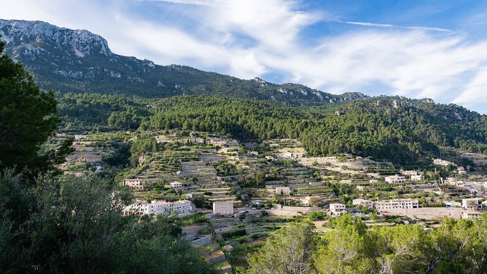

Volta des General lies where Mallorca’s coastal road makes a striking bend near Banyalbufar and the landscape opens toward the sea. From the road, the view extends across Banyalbufar, its tiered terraces and the coast of the Serra de Tramuntana. Right beside it begins the Camí de sa Volta des General, which leads through pine woods toward Port des Canonge.
This combination is precisely what makes the place interesting: anyone simply traveling along the Ma-10 can stop here briefly to enjoy the view. Those with more time can follow the historic coastal path and watch the scenery repeatedly change between trees, rocks and open stretches. Rather than a single panorama, Volta des General offers a sequence of perspectives on the sea and cliffs.
The location is suitable for travelers who want to understand Banyalbufar’s landscape without immediately planning a challenging mountain hike. Families also use the path, although its rocky sections, the terrain above the coast and the return journey must be taken into account. Volta des General is particularly rewarding for anyone wishing to combine a scenic stop with a hike, a visit to Banyalbufar or a detour to Port des Canonge.
History and significance
The present-day name goes back to a former military officer who owned property near the bend in the road: Francisco Cotoner y Chacón, Marqués de la Cenia. In hiking guides and excursion descriptions, the name of the bend gradually came to be used for the entire place and the path beginning there. A landscape landmark thus became an established name on Mallorca’s hiking maps.
Camí des Carabiners
Before “Sa Volta des General” became widespread through its use in guidebooks and among hikers, the path was known by other names. Camí des Carabiners and Camí de Son Bunyola d’Avall have been passed down. The path follows the terrain, runs through sections of woodland and past rock formations, and connects the area around Banyalbufar with Port des Canonge. Earth, loose stones and natural unevenness are as much a part of the scenery as brief, more open stretches with sea views.
Francisco Cotoner y Chacón
Francisco Cotoner y Chacón is associated with more than just the name of the bend. He is also cited as a supporter of the road between Esporles and Banyalbufar. Volta des General therefore recalls a time when opening up this rugged coastal region required considerable intervention in the terrain. The Ma-10 winds through the slopes of the Tramuntana.
The historical significance of Volta des General therefore lies less in a single structure than in its location. Here, road development, an older coastal path and Banyalbufar’s agricultural surroundings come together. The viewpoint is at once a road bend, the start of a hike and a window onto a landscape shaped over a long period by paths, estates and terraces.
What to see
As soon as you step out, it becomes clear that Volta des General is not limited to a single viewing platform. The first view appears at the sharp bend in the Ma-10: Banyalbufar lies on the hillside, with the terrain dropping toward the Mediterranean below. Those who then take a few steps along the Camí gradually leave the road behind. Pines, rocks and changing openings toward the coast now define the scenery.
The view of Banyalbufar
The distinctive form of Banyalbufar is easy to appreciate from the area around the start of the path. The village does not stand in isolation on flat ground but sits between mountain and sea in a landscape of tiered slopes. Particularly striking are the terraces, which run through the terrain like narrow ribbons. They belong to an extensive cultural landscape system whose roots reach back to the Andalusian-Islamic period.
These Marjades enabled steep land to be used for agriculture. They were complemented by a sophisticated system for collecting and distributing water. From the viewpoint, the walls initially appear as a graphic pattern across the slope; later, in the village itself, it becomes clear how closely paths, houses, gardens and water channels are interwoven. Volta des General is therefore a good place to view Banyalbufar not merely as an attractive cluster of pale houses but as an evolved cultural landscape.
Camí de sa Volta des General
Beyond the bend in the road, the landscape truly begins to change. The Camí runs mainly along an earth and natural track. In some places, stones lie on the path, and paved sections are added only when approaching Port des Canonge. The route is comparatively gentle but not completely level. Particularly on the return journey, it becomes noticeable that parts of the route lead uphill.
The path runs through pine forest above the coast. At first, the Mediterranean appears in glimpses between the trunks; then larger windows open onto the water and the rocky shoreline. Some of the pines lean toward the sea, and the influence of the coastal wind is visible in exposed places. Instead of an uninterrupted open panorama, the route creates a rhythm of shade, forest and sudden expanses.
The cliffs
On the open stretches, the path’s position at the edge of the Serra de Tramuntana becomes especially vivid. The terrain below the path drops toward the sea, while rocks and wooded slopes rise inland. From here, the coastline does not look like a continuous beach but like a succession of headlands, small coves and steep slopes.
The view changes with every section. Sometimes the deep blue of the open Mediterranean takes center stage, and sometimes the rocky coast does. This continuous process of discovery is precisely what distinguishes the Camí from a viewpoint where everything has already been seen after a single photo. Those who continue walking encounter ever-new perspectives without having to climb a summit.
The rock overhang
One of the most distinctive parts of the path is a section beneath an overhanging rock face. Here, the rock presses close to the Camí, while the coastal landscape remains visible on the other side. The overhang is not a constructed feature but a natural formation and a particularly memorable motif along the route.
The contrast is appealing: heavy rock hangs above the path while the vastness of the sea opens beside it. This spot shows particularly clearly how closely the historic path follows the natural contours of the terrain. Nevertheless, attention should not be focused only outward, as uneven ground and stones require care, especially when other hikers approach from the opposite direction.
The red rocks near Port des Canonge
Those who use Volta des General not merely as a brief scenic stop but continue along the path toward Port des Canonge will experience a striking change in color. The ground and rock increasingly take on deep red tones. This is caused by their high iron content, which is relatively unusual in this form on Mallorca.
The red provides a clear contrast to the blue of the sea and the green of the pines. It is one of those details that can easily be overlooked in photographs of the broad coastal panoramas but defines the character of the final part of the path when seen in person. The Camí eventually ends in the small coastal settlement of Port des Canonge, situated between steep slopes and the open sea.
Visiting Volta des General
A brief stop and a hike are two very different ways to visit Volta des General. For the view alone, a manageable break at the bend in the road is enough. The real experience begins, however, as soon as the traffic noise from the Ma-10 fades beyond the first bends in the path and the Camí continues between pines and the coast.
A brief scenic stop
Anyone traveling along the Ma-10 with little time can enjoy the view of Banyalbufar and its terraced landscape from the area around the start of the path. Careful attention should be paid to the road, however: the entrance lies on a pronounced bend, and the parking area is small. Stopping is worthwhile only if the vehicle can be parked fully and safely.
Even this brief visit conveys the place’s essential features. The hillside of Banyalbufar, its terraces and the Mediterranean are all visible. Its appeal comes from the location and the transition between road, cultural landscape and coastal path.
The hike to Port des Canonge
For the hike, one account of a trip with children gives a walking time of approximately 1 hour 15 minutes for the outward journey. The return journey, which is partly uphill, took about 1 hour 45 minutes. These figures are not a guarantee: breaks at the viewpoints, the children’s ages, the condition of the path and your own pace can significantly change the duration of the excursion.
Anyone walking as far as Port des Canonge should plan the return journey from the outset. The outward route often feels easier because of its gentle downward direction; the additional climbs on the way back only become noticeable later. For the complete trip, it therefore makes more sense to reserve a generous portion of the day than to attempt a spontaneous detour shortly before nightfall.
Time of day and crowds
The bottleneck is less on the long path than at the starting point, as the small parking area on the bend fills quickly. An early start also brings greater peace on the first sections of the path and leaves enough time for breaks.
After rain, rocky and earthy sections require additional care. Anyone coming only for the distant views should choose a clear day if possible; those wishing to hike should consider the condition of the path as well as visibility.
Getting there and parking
The final kilometers to Banyalbufar are already part of the experience. The road reaches the western Tramuntana, becomes more winding and follows the deeply folded slopes. The distance alone should therefore not be used to judge the journey, as travel takes longer on the narrower, winding sections than a road map might initially suggest.
From Palma Airport
The road distance from Palma Airport to Banyalbufar is 39 kilometers. The journey takes around 77 minutes and follows Ma-20, Ma-1110 and Ma-1120. These details expressly apply only as far as Banyalbufar. From there, continue along the Ma-10 toward the distinctive bend at the start of the Camí de sa Volta des General.
The final section requires attention. The Ma-10 winds through the slopes, and the small parking area at the starting point can easily be missed. Driving slowly and looking ahead is more important here than arriving at a precise minute. Turning around or stopping abruptly on the bend should be avoided.
From central Palma
The road distance from central Palma to Banyalbufar is 34 kilometers. Via Ma-1110, Ma-1120 and Ma-10, the journey takes around 82 minutes. This travel time also ends in Banyalbufar for calculation purposes, not directly at Volta des General. The final section follows the Ma-10 to the bend with the small parking area and the entrance to the coastal path.
The unusually long travel time for a manageable distance is explained by the road layout in the Tramuntana. Beyond Esporles, the bends become tighter, and a calm pace is advisable. Time pressure is poorly suited to this route, particularly since oncoming traffic and the search for a safe parking space may take additional minutes.
Parking and buses
There is only a small parking area directly at the starting point. Particularly in spring and summer, it may already be full by the morning. If no safe space is available, drivers should not improvise by parking at the edge of the bend.
Banyalbufar and the Miramar area are served by regional buses. However, the stops are not located directly on the Camí, so an additional walk must be planned to reach the viewpoint. Before setting out, it is advisable to check the current timetable and the appropriate walking route between the bus stop and Volta des General.
Bus lines to Volta des General at a glance
| Line | Route | Departures/day | First | Last |
|---|---|---|---|---|
| 202 | Estellencs - Palma | 112 | 06:45 | 21:31 |
| 131 | Santa Ponça - Banyalbufar | 10 | 11:25 | 16:18 |
From the official GTFS feeds (TIB/SFM), no real-time data. The figures cover all stops in the town; weekend and holiday services differ — check with the operator before travelling.
Getting there by bus
Miramar 2 (7006) · 0.3 km as the crow flies
- 131Santa Ponça - Banyalbufar · Daily
- 202Estellencs - Palma · Daily
Miramar 1 (7015) · 0.3 km as the crow flies
- 131Santa Ponça - Banyalbufar · Daily
- 202Estellencs - Palma · Daily
Banyalbufar 2 (7003) · 0.7 km as the crow flies
- 131Santa Ponça - Banyalbufar · Daily
- 202Estellencs - Palma · Daily
Banyalbufar 1 (7002) · 0.8 km as the crow flies
- 131Santa Ponça - Banyalbufar · Daily
- 202Estellencs - Palma · Daily
Torre des Verger (7004) · 1.9 km as the crow flies
- 131Santa Ponça - Banyalbufar · Daily
- 202Estellencs - Palma · Daily
Timetable data: official GTFS feeds (TIB/EMT), no real-time — check with the operator before travelling.
Nearby places
Volta des General initially presents Banyalbufar from a distance. Afterward, it is worth driving into the village and viewing the terraces previously seen from above at close range. Narrow lanes, steps and steep connections make it clear how consistently the village has adapted to the slope.
Banyalbufar
The cultural landscape around Banyalbufar dates back to an Andalusian community. Its terraces and system for collecting and distributing underground water created the basis for agriculture on the steep slopes. From Volta des General, this system looks like a large pattern; during a walk through the village, it becomes a network of walls, gardens, paths and water basins.
Banyalbufar is therefore the most logical addition to the viewpoint. A visit combines the overview from outside with an experience from within the landscape. Anyone wishing to reach the water can include Cala Banyalbufar in the day’s plans. Given the hillside location, enough energy should be reserved for the descent and subsequent return climb.
Port des Canonge
Port des Canonge is the natural destination of the Camí de sa Volta des General. The small coastal settlement lies between steep slopes and the sea. Those who reach it on foot experience not only the changing views along the way but also the red, iron-rich soils and rocks in the final part of the route.
Port des Canonge should not be treated as a brief addition after an already long hike: the return route to Volta des General is partly uphill. Anyone wishing to continue by vehicle should bear in mind that the road connection and the hiking trail offer two different ways of approaching the place. The Camí is the more immediate scenic connection but also the more physically demanding one.
Esporles and the coastal road
Esporles lies on one of the main approach routes to Banyalbufar. The town is suitable as an intermediate stop before the road becomes more winding as it enters the Tramuntana. In Banyalbufar itself, the Camí des Correu, the old postal route toward Esporles, also begins. However, it is a separate hike and should not be confused with the Camí de sa Volta des General.
Anyone continuing along the Ma-10 beside the coast can combine the viewpoint with other places in the western Tramuntana. Rather than packing in a dense sequence of many stops, however, it makes more sense to choose a clear focus: either a short day exploring the landscape around Banyalbufar and its viewpoints or an extended hike along the Camí to Port des Canonge.
The place it belongs to
Banyalbufar in the place guidePractical information for your visit
The first few meters of the Camí may seem straightforward, but the surface remains a natural path. Earth, stones and uneven sections alternate. Sturdy shoes with good traction are therefore more suitable than smooth-soled sandals. After rain, earthy sections may be more slippery, while loose stones require attention even in dry weather.
Sun and shade
The pine woods provide shade on parts of the path. Nevertheless, the route is not completely protected: at the scenic sections it opens toward the sea, and the sun falls directly on the path. Sun protection and drinking water should therefore be carried even if the start in the woods feels pleasantly cool.
With children
The route is described as a family hike and has also been completed with children. Nevertheless, sure-footedness, stamina and reliable behavior above the coast are essential. A stroller is not suitable for the rocky natural path. Younger children need assistance on uneven sections and should stay close to adults in open areas.
When planning the time required, the outward journey is not the only factor to consider. On one documented trip with children, reaching Port des Canonge took about 1 hour 15 minutes, while the return took about 1 hour 45 minutes. Additional breaks for views, food or swimming extend the day. Turning back early is always the better decision if energy or concentration begins to fade.
What to expect from the viewpoint
The bend in the road, the view of Banyalbufar and the beginning of a historic coastal path define a visit here. For precisely that reason, the place should not be treated as a quickly consumed attraction. It is best appreciated on foot, as even a short section along the Camí changes the perspective and creates distance from the road.
Anyone continuing as far as Port des Canonge should, however, treat it as a proper hike with suitable footwear, water, sun protection and enough time. The small parking area, natural surface and uphill return route are not minor details but factors that shape the entire visit.
Local insider tips
Arrive early for the small parking area
In spring and summer, it is worth arriving before 10 a.m. The parking area on the sharp bend is small; later, finding a space can make the planned scenic stop or start of the hike considerably more difficult.
Do not turn back at the bend
The view from the Ma-10 is only the beginning. Even a short walk along the Camí leads away from the road between pines and opens up new glimpses of the cliffs and Mediterranean.
Look out for the rock overhang
A particularly distinctive section lies beneath an overhanging rock face. Here, the rock rising closely above the path and the open coastal view meet directly.
Red earth at the destination
On the final section before Port des Canonge, the ground and rocks change color. The high iron content creates deep red tones that contrast clearly with the blue of the sea and the green of the pines.
Save energy for the return journey
The route to Port des Canonge feels easier than the return journey. On one documented trip with children, the outward journey took about 1 hour 15 minutes, while the partly uphill return took about 1 hour 45 minutes.