
Santuari d'Almallutx – Mallorca's Sunken Sanctuary
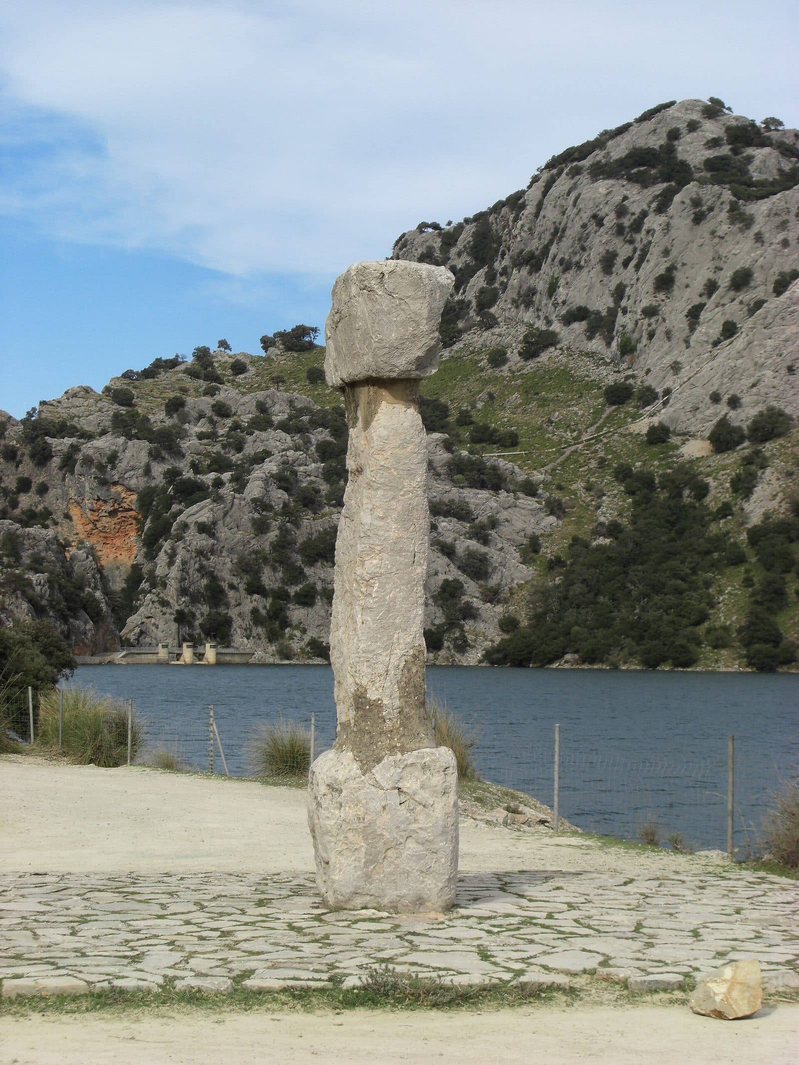

Santuari d'Almallutx is one of those archaeological sites in Mallorca that cannot be understood at a glance. The ruins are not presented as a prepared circuit outside a visitor center but lie beside and partly within the Gorg Blau reservoir, high in the Serra de Tramuntana. Depending on the water level, sections remain hidden or re-emerge into the landscape. This constant change is precisely what makes Almallutx an extraordinary testament to the island's history.
At its heart are several sanctuaries of the Talayotic culture. Their large central pillars are particularly striking, and there is no known comparable complex of this form in Mallorca. There are also remains of settlements and other buildings. The ensemble was therefore not a single temple but part of a much larger archaeological site.
A visit is especially rewarding for people interested in prehistory, ritual landscapes, and Mallorca's less visible layers. Do not expect a conventional attraction with a museum, reconstructed rooms, and a signposted circuit. Almallutx demands close observation—often from the opposite side of the road across Gorg Blau and with an awareness that a large part of the site may lie underwater.
The location reference Cala Tuent places the site within the wider northwestern region. The archaeological sanctuary itself, however, lies at Gorg Blau in the mountains of Escorca, not directly on the coast or at the beach of Cala Tuent. Anyone wishing to combine both destinations should therefore plan for a drive through challenging Tramuntana terrain.
History and significance
Before the Gorg Blau reservoir existed, numerous archaeological remains lay exposed in the high valley of Almallutx, within a landscape used for farming. Construction of the reservoir fundamentally transformed this historic area. Because it was clear that the water would cover large parts of the site, archaeological investigations took place in 1969 and 1970. A total of eleven buildings were examined—a rescue excavation carried out under the time pressure of an impending transformation of the landscape.
The Talayotic period
According to archaeological classification, the site's history reaches back to the 7th century BC and thus to the Iron Age of the Balearic Islands. Almallutx is attributed to the Talayotic culture, whose communities left characteristic stone buildings, settlements, and ritual sites in Mallorca and Menorca. The site consisted of more than sanctuaries: remains of settlement areas have also been identified. Religious practices and everyday life apparently existed here in close proximity.
Use of the site continued until the period of the Roman conquest. It therefore encompasses several centuries of social and religious development. The suggestion that Almallutx may at times have been an important religious center of the island is supported by the unusual concentration of several sanctuaries, two settlement areas, and further archaeological traces. Nevertheless, the site should not be misunderstood as a definitively proven capital or island-wide center; its exact role remains a matter of archaeological interpretation.
A ritual site in the high mountains
The location alone distinguishes Almallutx from many more accessible archaeological sites. The high valley lies near Puig Major and is surrounded by some of Mallorca's highest peaks. The prehistoric inhabitants did not merely construct a single remote building here but a complex of several sanctuaries and settlement remains. The size of the archaeological area and the distinctive form of its ritual buildings give the site its significance.
Specific finds provide a cautious glimpse into what took place inside the buildings. Vessels containing animal remains were discovered in one of the sanctuaries. They point to practices in which animals or animal products played a role. The finds alone cannot reveal exactly how the rituals were performed, which deities were worshipped, or who was permitted to participate. This boundary between visible evidence and unknown meaning is central to the experience of Almallutx.
The reservoir as a turning point
When Gorg Blau was flooded, water became part of the sanctuary's history. Some structures disappeared permanently or temporarily beneath the surface, while others remained visible on the slopes. When the level falls during dry periods, sections of the site emerge more clearly; when it rises again, investigation becomes difficult or impossible. These fluctuations not only affect access but also limit new archaeological work.
Today, Santuari d'Almallutx has the status of a Bien de Interés Cultural, a protected cultural asset. This designation emphasizes its historical value but does not turn the site into a conventional visitor park. Almallutx remains a sensitive archaeological landscape whose appearance is shaped by the water level, the view across the reservoir, and a respectful distance from the ruins.
What to see
The first thing that catches the eye is not a façade but the distribution of traces across the landscape. The archaeological remains lie in two groups on different sides or slopes of the present-day reservoir. One section is on the northwestern slope, while another lies on the opposite side of the lake. From the road across the water, the areas can be viewed from a distance, especially when the level reveals individual walls and pillars.
The three sanctuaries
Three sanctuaries have been identified at Almallutx. One lies in an area that can be covered by the reservoir's water. Two more belong to the group containing the remains of a settlement on the opposite side. The buildings were constructed from large stones and are chiefly characterized by their massive pillars in the center.
These central supports are the site's defining feature. Almallutx is regarded as Mallorca's only known sanctuary complex with central pillars of this size. Their impact comes not from ornament or figurative decoration but from mass, height, and position: inside, they focused the space on a stone center. Whether the pillars supported only the roof, also held symbolic meaning, or combined both functions cannot be determined with certainty from the surviving evidence.
Santuario 2
The building known as Santuario 2 is documented in particularly specific detail. It stands on higher ground and resembles the first sanctuary. Its floor plan measures 6,6 by 7,3 meters, while the central pillar reaches 3,7 meters. These dimensions help clarify its scale: this was not a tiny niche but a clearly defined interior with a monumental stone at its center.
Inside this sanctuary, the excavators found several vessels containing animal remains. For visitors, this detail is more valuable than an imaginative reconstruction. It links today's silent walls with real actions from the past. People carried vessels into the space, placed animal material inside them, and incorporated the central pillar into an architecture whose religious rules can no longer be fully understood.
The settlement remains
Alongside the ritual buildings, remains of two settlements or settlement areas were identified. The site was therefore more than an isolated sanctuary visited only occasionally. Walls and traces of buildings reveal a larger living environment where people built, lived, and presumably worked. Agricultural activity in later periods exposed further archaeological remains but also damaged parts of the site.
For anyone viewing the site today, this means that not every low stretch of wall can be clearly identified without a plan as a house, ritual building, or other structure. The landscape is not a fully excavated urban ground plan. What matters instead is the interplay of stonework, hillside setting, central pillars, and areas cut through by the water.
The pillars by the water
When the water level is higher, the visible scene may be reduced to a few structural elements rising from the water or standing along the shore. The pillars in particular then become points of orientation. Binoculars or a camera lens with zoom help identify them from the opposite side of the road and understand their position in relation to the wall remains.
At low water, more of the archaeological topography becomes visible. This does not automatically mean, however, that the site is easy or open to access. Between the road and the ruins lie the reservoir, private land, and difficult rocky passages. The best view of the sanctuary is therefore often not a close-up but the wider perspective: the scattered buildings reveal how closely the ritual site, settlement, mountain slope, and present-day reservoir are intertwined.
Visiting the site
A visit to Almallutx begins by checking the conditions, not by walking to a ticket desk. The water level at Gorg Blau determines which sections are visible and whether approaching them is even conceivable. During wetter periods, ruins may be flooded. More structures emerge during severe drought, but the route remains difficult and does not follow a prepared visitor trail.
The view from the road
The most reliable way to see the site is from the road on the opposite side of the reservoir. From there, the ensemble can be understood within its landscape. Some remains appear inconspicuous to the naked eye; binoculars or a telephoto lens make the pillars and wall lines easier to distinguish. Above all, it helps to remember the site's basic layout beforehand: three sanctuaries, several central pillars, and settlement remains in two spatially separate groups.
This distant view is not an inferior substitute for a walking circuit. Instead, it reveals a historical truth about the site: the complex was divided and reshaped by the reservoir. The water not only conceals archaeological remains but has itself created the present-day appearance of Almallutx.
Approaching the ruins
Direct access is problematic. The documented route crosses the Almallutx estate and then passes through an awkward section between rocks. Private land must not be entered without permission. A low water level is therefore not an invitation to descend to the site independently. The water level, terrain, and ownership conditions must be clarified before any attempt to approach the ruins.
The terrain requires more than ordinary city-walking equipment. Loose stones and rocky passages make sturdy footwear essential. Anyone simply planning a cultural and historical stop during a drive through the Tramuntana is better advised to take in the overview from the accessible roadside and respect barriers and property boundaries.
Timing and daily rhythm
There is no reliable standard duration for Almallutx. A short overview is possible when the pillars and wall lines can be clearly seen from the road. Anyone wishing to study the distribution of the ruins in more detail, take photographs, and wait for changing views across Gorg Blau will need correspondingly more time. There is no fixed circuit of a predetermined length.
The water level is more important for visibility than a particular time of day. Opening hours and admission details are also not reliably documented. Before setting out, check whether any current restrictions apply and what form of visit is permitted. The site is suitable for a spontaneous detour only if you accept that there may be little more to see than the landscape, water, and a few archaeological traces.
Getting there and parking
The long journey is part of the experience. Almallutx lies in Mallorca's mountainous northwest, within the municipality of Escorca and beside Gorg Blau. The routes recorded for this page lead as far as Cala Tuent; they explicitly do not end directly at the ruins. The road distance from Palma Airport to Cala Tuent is 72 kilometers. The drive takes around 105 minutes and follows Ma-30, Ma-13, and Ma-2130.
From central Palma, the road distance to Cala Tuent is 69 kilometers. Allow around 109 minutes; the recorded route follows Ma-13 and Ma-2130. The unusual relationship between distance and travel time is explained by the winding mountain drive in the final section. These figures should therefore not be understood as a simple transfer time to an easily accessible museum.
From the road network to Gorg Blau
The sanctuary lies beside the reservoir and can be viewed from the road on the opposite side. Anyone traveling specifically to see Almallutx should therefore navigate toward Gorg Blau rather than the beach at Cala Tuent. The final approach to the archaeological site is not a regular access road: getting close may involve crossing private property and negotiating a difficult rocky passage, and higher water levels may block it entirely.
Ma-10 crosses Escorca and the Serra de Tramuntana. It provides access to the mountain region but does not offer a route directly to the walls. When planning the journey, clearly distinguish between stopping at a viewpoint overlooking the site and entering the archaeological area itself. The latter should only be attempted when access, water level, and permission have all been clearly confirmed.
Parking and public transport
There is no documented regular visitor entrance at the sanctuary from which a parking area and walking circuit begin. Vehicles may only be left where parking is expressly permitted and does not obstruct traffic on the mountain roads. A seemingly good view of the ruins does not justify stopping on a blind bend or narrow carriageway.
No bus stop is recorded in the immediate vicinity. Public transport is therefore unsuitable for reaching Santuari d'Almallutx directly. A boat connection to Cala Tuent also does not take visitors to the sanctuary at Gorg Blau. For an archaeological visit, a carefully planned drive through the Tramuntana remains the practical basis.
Bus lines to Santuari d'Almallutx at a glance
| Line | Route | Departures/day | First | Last |
|---|---|---|---|---|
| 231 | Port de Sóller - Alcúdia | 4 | 11:40 | 19:55 |
From the official GTFS feeds (TIB/SFM), no real-time data. The figures cover all stops in the town; weekend and holiday services differ — check with the operator before travelling.
Getting there by bus
Cúber 1 (19013) · 2.8 km as the crow flies
- 231Port de Sóller - Alcúdia · Daily
Timetable data: official GTFS feeds (TIB/EMT), no real-time — check with the operator before travelling.
Nearby
The ruins of Almallutx and Cala Tuent represent two very different sides of the Serra de Tramuntana. At Gorg Blau, the reservoir, high mountains, and archaeological traces shape the view; on the coast, a large natural bay opens toward the sea. Both destinations can be combined in a day trip, but the winding road prevents this from being a casual pairing.
Cala Tuent
Cala Tuent lies between Sa Costera and Sa Calobra. The bay is surrounded by forest and high mountains and has a largely unspoiled beach. After concentrating on pillars and wall lines, the coast offers a distinct change of perspective: here the mountains are bounded not by a reservoir but by the open sea.
This combination is particularly suitable for travelers already planning to drive to Cala Tuent. The stated road distances and journey times from Palma refer to the bay, while Almallutx lies at Gorg Blau. The two locations should therefore be entered separately into navigation systems rather than treated as a single destination.
Gorg Blau and Puig Major
Gorg Blau is not merely a backdrop but the decisive factor in the sanctuary's current appearance. Its water covers archaeological areas, separates visible groups, and reveals new outlines when the level falls. The view across the reservoir provides an immediate explanation of why rescue excavations were necessary before the flooding.
The mountains around Puig Major rise above the area. They give the site its unusual setting and explain why Almallutx is often described as a sanctuary in Mallorca's highest regions. A stop here therefore offers more than an isolated ruin: it reveals a cultural landscape whose historical layers were transformed by modern water supply infrastructure.
Sa Calobra and Escorca
Sa Calobra is another possible coastal destination in the region, but the mountain roads mean it should not be squeezed too tightly into the same day's itinerary. The Escorca area also offers hiking trails and further historic sites. Almallutx remains a distinct archaeological focus: neither a Christian monastery nor a viewpoint that happens to share part of its name belongs to Santuari d'Almallutx.
For a well-balanced route, combining Gorg Blau and Cala Tuent is often enough. It leads from a partly submerged ritual site to the Tramuntana coast and shows how water shapes the landscape in two completely different ways.
The place it belongs to
Cala Tuent in the place guidePractical information for your visit
The most important item to bring is not a guidebook but binoculars. Many details lie on the other side of the water and look like ordinary rocks without optical assistance. Anyone who knows beforehand to look for the large central pillars and low wall lines will find it much easier to understand the site's layout.
Footwear and terrain
Sturdy shoes with good grip are required for every step away from paved surfaces. The described access to the ruins crosses difficult terrain and passes between rocks. A low water level may expose parts of the site but does not remove loose stones or steep and awkward passages.
Even in good conditions, Almallutx is not a place for an unplanned walk. Private property, protected status, and a fluctuating water level create clear limits. Anyone without confirmed access should view the complex from a distance.
Visiting with children
With children, the best option is a short, supervised view from a safe and permitted location. The open, rocky terrain beside the reservoir and the difficult access to the ruins require constant attention. The site does not have a prepared educational trail, play area, or enclosed museum space.
Older children may find the place fascinating if its history is explained beforehand: beneath the water lie parts of an Iron Age settlement and ritual landscape, while individual pillars may remain visible. Without this preparation, however, the site may look like a collection of distant stones.
What not to expect
Santuari d'Almallutx is not a preserved house of worship or a religious sanctuary still in use today. There is neither an ornate interior nor a complete reconstruction of the Talayotic buildings. What can be seen are archaeological remains whose extent changes with the water level.
Nor should visitors expect an exhibition explaining every ritual. The vessels containing animal remains provide evidence of ritual practices but do not answer every question. The site's appeal lies precisely in carefully reading a small number of traces: a massive pillar, a partially exposed stretch of wall, and a reservoir that both preserves and conceals part of the story.
Local insider tips
Binoculars instead of close access
The most reliable views are from the roadside opposite the ruins. Binoculars or a telephoto lens make the large central pillars and low wall lines much easier to identify across the water.
Check the water level first
The visibility of Almallutx depends more on the level of Gorg Blau than on the time of day. More structures emerge when the water is low, but direct access remains difficult and may cross private land.
Look for the central pillar
The easily overlooked key feature is the monumental pillars at the center of the sanctuaries. Santuario 2 has a 3,7-meter-high central pillar—part of a sanctuary type unique in Mallorca.
Keep the ritual evidence in mind
Vessels containing animal remains were found in Santuario 2. Knowing this detail makes it possible to see the walls not merely as structural remains but as the setting for specific religious practices of the Talayotic community.
Combine it with Cala Tuent
Gorg Blau and Cala Tuent reveal two contrasting water landscapes in the Tramuntana: here, a reservoir above archaeological remains; there, an unspoiled coastal bay. Allow sufficient time because of the mountain roads.