
cova de sa Gleda – Mallorca’s Hidden Underwater Labyrinth
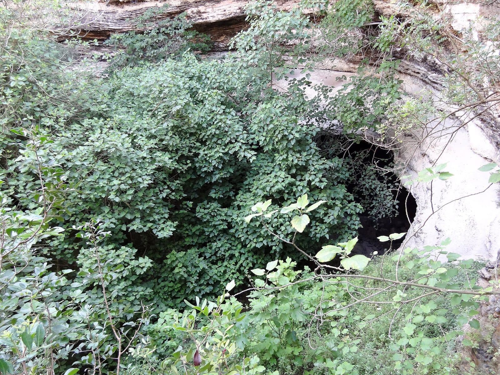

Beneath the unassuming limestone landscape near Cales de Mallorca lies a natural environment whose true extent is almost impossible to imagine from the surface. The cova de sa Gleda, also known as Cova de sa Gleda–Camp des Pou, is a predominantly flooded water and stalactite cave with an extensive network of passages, chambers and underwater sections. It is not one of Mallorca’s illuminated show caves, but part of a hidden underground world mapped and scientifically studied primarily by cave researchers.
This difference is precisely what makes it so significant. There is no developed visitor route in the cova de sa Gleda, no dramatically illuminated formations and no groups following railings. Most of the system lies underwater. Those familiar with its images see a world of limestone, speleothems, dark cavities and dive lines where navigation and technical preparation are essential for survival.
For travelers, the cave is therefore more of a geological key to understanding Mallorca’s east coast than a conventional attraction. Cales de Mallorca and the coastal area of the municipality of Manacor lie on heavily karstified limestone; caves run through the ground in many places and sometimes open toward the sea. Sa Gleda reveals how much larger this landscape can be beneath the visible surface.
A visit is therefore worthwhile primarily as a conscious encounter with a protected natural phenomenon. The cave is not a place for spontaneous swimming, snorkeling or ordinary recreational diving. Access has been prohibited since 2014; special permits are granted for scientific work. Anyone looking for a freely accessible stalactite cave should not confuse Sa Gleda with the tourist caves around Porto Cristo.
History and significance
The exploration began in the simplest imaginable way: a diver was lowered into the water on a rope. When Francesc Ripoll explored the first 50 meters of the system in 1974, he wore a simple rubber suit and carried only one oxygen tank. From today’s perspective, this equipment appears extremely rudimentary. At the same time, the episode illustrates how little was then known about the cave’s size and complexity.
The first explorations from 1974
Ripoll’s advance opened up only a tiny section. Beyond the entrance was not a clearly arranged cavity but a branching system whose passages are predominantly flooded. Further exploration therefore required not only speleological expertise but also specialized cave-diving techniques. Unlike diving in the open sea, divers in an underwater cave cannot simply ascend vertically to the surface. The return route leads through the same passages, and disturbed sediment can severely reduce visibility within a short time.
Nevertheless, these early investigations marked the crucial beginning. Without the two known entrances, the system would probably have remained hidden, like many other cavities in Mallorca’s karstified ground. The two entrances lie slightly less than two kilometers apart. Only systematic mapping revealed that they belong to a single, much larger cave complex.
Research since 1997
A new phase began in 1997. Xisco Gràcia and other cave researchers from Grup Nord de Mallorca investigated Sa Gleda on behalf of the University of the Balearic Islands. Financial support came from the Sa Nostra savings bank and funded powerful light sources as well as photographic and filming equipment, among other things. The underwater work involved more than simply finding new passages: every explored section had to be surveyed, documented and secured with a reliable system of guide lines.
By 2011, this research had accumulated around 2,000 working hours over 400 days. Individual expeditions lasted between two and six hours. These figures explain why exploration of an underwater cave progresses over many years: equipment must be transported through narrow or confusing passages, junctions must be marked unambiguously, and every advance is limited by the breathing-gas reserves carried by the divers.
Camp des Pou
The extended name Cova de sa Gleda–Camp des Pou refers to the landscape above the cave system. “Camp des Pou” describes a field of wells. Residents traditionally dug there for drinking water without being able to know the full extent of the labyrinth beneath them. The name thus connects two levels of the same karst landscape: the visible wells above and the water-filled passages and chambers below.
Today, Sa Gleda is regarded as an exceptional natural site and research subject. The known system reaches a total length of 13,500 meters and has a vertical range of 24 meters. It is classified as Europe’s longest underwater cave and ranks among the world’s major known systems of this kind. Its significance lies not in tourist presentation, but in its geology, biology and the insight it provides into the hidden aquatic spaces of Mallorca’s east coast.
What there is to see
What is truly worth seeing remains inaccessible to ordinary visitors. Photographs and scientific documentation nevertheless show why the cova de sa Gleda has such a special reputation among cave researchers: beyond the entrances lies not a single cavern but a three-dimensional network of flooded passages, larger chambers, constricted sections and dry or air-filled areas.
The underwater labyrinth
More than 13 kilometers of explored passages run largely below the waterline and approximately parallel to Mallorca’s east coast. Broad chambers alternate with winding connections. Underwater junctions cannot be interpreted using daylight or an identifiable main direction. Researchers therefore navigate by means of permanently installed guide lines, with small plastic arrows at the branches pointing toward the exit.
These lines are not decorative markers but part of a vital safety system. In good visibility, a diver may still be able to recognize the structure of the passage; if fine sediment is disturbed, tactile contact with the line may be all that remains. The image of cave divers apparently floating weightlessly through clear chambers therefore tells only one half of the story. The other consists of redundancy, meticulous route planning and constant protection of the return route.
Chambers, passages and air-filled areas
The system contains spaces of very different sizes. Some passages lie completely underwater, while other areas extend above the waterline. In these air chambers, the experience of the cave changes fundamentally: after the muted sound of breathing regulators, a cavity opens where divers can speak and check their equipment. Such areas have also been used for interim checks during documented dives.
Nevertheless, the chambers are not stops on a circular route. Their position within the labyrinth and the long flooded approaches make them parts of a demanding cave-diving route. Even experienced open-water divers cannot infer from this that they are qualified to visit independently. Cave diving requires its own procedures, specialized training and equipment designed for the underground return journey.
Speleothems in the flooded cave
Sa Gleda is both a water cave and a stalactite cave. Calcium carbonate deposits form natural structures on ceilings, walls and floors. Some of these formations developed under different water-level conditions before the respective sections were flooded. Today, they appear underwater as stone columns, curtains or irregular sculptures. The only light comes from the researchers’ lamps; outside their beams, the space remains completely dark.
This combination of speleothems and flooding distinguishes Sa Gleda from a mere fissure in the rock or a sea grotto opened by wave action. The cave system extends beneath the land and lies below sea level. It is therefore not a coastal cave into which swimmers could simply enter from a bay.
The halocline
A striking phenomenon found throughout the cave is the halocline. This is where layers of water with different salinity levels meet. When divers pass through it, the boundary zone can make the image appear shimmering and blurred even though the water itself is clear. This presents a particular challenge for photography: the movement of a diver alone mixes the layers and alters the optical effect.
At the same time, the halocline makes visible how underground freshwater and saltwater meet within the coastal karst. Sa Gleda is therefore not merely a large cavity but a sensitive hydrological system. Movement, sediment input and changes at the entrances affect a natural environment whose individual parts are connected by long underground passages.
The two entrances
Two known entrances provide access to the system. They lie slightly less than two kilometers apart and allowed researchers to prove the connection between widely separated sections of the labyrinth. From the outside, however, these openings give no impression of the system’s overall extent. By far the largest part remains hidden beneath the surface.
This is perhaps the most powerful lesson conveyed by Sa Gleda: an unspectacular-looking opening can provide access to a natural environment extending for kilometers. This is precisely why the need for protection is so understandable. Where the essential features remain invisible, uncontrolled access would be especially risky—for people as well as for the sensitive cave.
Visiting the cave
There is no queue outside Sa Gleda and no signposted route inside. However, this does not mean that the cave is a quiet hidden gem for independent exploration. Access has been prohibited since 2014; special permits are granted for scientific purposes. A conventional visit, a spontaneous dive or a short detour into the entrance passage are therefore not permitted forms of access.
No tourist cave tour
Anyone who discovers the name on a map should set the right expectations from the outset. Sa Gleda is not organized like a show cave. There is no documented visitor tour, no lighting, no paved paths and no standard duration for a visit. The statement “free admission” merely means that no admission fee is charged. It does not mean unrestricted access and does not override the access restrictions.
No opening hours are recorded. Since access and protection rules may change, current regulations should be checked before any approach. The key point remains: without explicit permission, the cave is not an attraction that may be entered or dived. A visit therefore cannot reliably be planned for half an hour, a morning or a scheduled guided tour.
Why ordinary divers must stay outside
Clear, comparatively warm water can visually understate the difficulty of an underwater cave. In reality, the same fundamental risks apply here as in cold or murky cave systems. A direct ascent is impossible, the exit may lie far beyond several junctions, and failure of a light or breathing-gas supply has different consequences beneath a rock ceiling than in open water.
The documented research clearly demonstrates the effort involved. Lines were installed over kilometers, every junction had to be marked with directional arrows, and even trained teams spent many years surveying and exploring. A sea-diving qualification, snorkeling experience or physical fitness is no substitute for cave-diving training. Carrying a lamp also does not turn an unknown passage into a safe route.
What travelers can still learn
Sa Gleda changes the way visitors see the landscape around Cales de Mallorca. No monumental rock architecture is visible above the system. It is precisely the knowledge of the kilometers of cavities beneath the limestone that makes the place remarkable. Wells, karst surfaces and cave openings no longer appear as isolated features but as visible traces of a largely invisible underground environment.
For an actual cave experience, only regularly accessible tourist alternatives should be considered. Sa Gleda itself should be understood as a protected research area. Here, a respectful visitor experience does not consist of penetrating as deeply as possible, but of recognizing the boundary between a public attraction and a sensitive natural environment.
Getting there and parking
The stated routes lead to Cales de Mallorca, not to a cave entrance open to visitors. This distinction is important: Sa Gleda has no documented tourist access point to which travelers can simply continue driving after arriving at the resort. The final section should therefore not be sought independently across private property, farm tracks or unmarked access roads.
From Palma Airport
The route from Palma Airport to Cales de Mallorca covers 62 road kilometers. The drive takes around 55 minutes and follows the Ma-19, then the Ma-5120 and the Ma-4010 toward the east coast. Depending on traffic, the route begins on the wider roads around Palma before continuing along the regional connections in the eastern part of the island.
These directions expressly end in Cales de Mallorca. They are not directions to Sa Gleda and should not be interpreted as indicating a public parking area at the cave. Anyone visiting the area because of its karst landscape should remain on public roads and respect barriers as well as private or protected land.
From central Palma
From central Palma, the distance to Cales de Mallorca is 67 road kilometers. The drive takes around 64 minutes. The route follows the Ma-15, the Ma-4015 and the Ma-4014. Here too, the travel time applies to the town, not to a cave entrance. No regular visitor route onward to Sa Gleda is documented.
Cales de Mallorca is readily accessible by car due to its location in the east of the island, but a rental car does not grant a right of access. Especially at natural sites without ticket offices or visitor centers, a map can easily create the false impression that every marked point has been made accessible to the public. For Sa Gleda, the tourist journey should therefore sensibly end within the town.
Parking and public transport
No designated visitor parking area at the cave is recorded. Vehicles should not be left on narrow access roads, in front of gates or on unmarked land. Parking should be restricted to the regular street network of Cales de Mallorca wherever local signs permit it.
No bus stop is recorded within the cave’s immediate vicinity either. Public transport is therefore unsuitable for a targeted journey to the entrance. Since independent visits are not intended in any case, the cave should not be planned as a walking destination from a distant stop. Cales de Mallorca serves as the regional reference point for orientation; the protected cave remains separate from it.
Nearby
Cales de Mallorca lies on the east coast between Porto Cristo and Portocolom, immediately north of Cala Murada. The resort extends across a limestone formation riddled with numerous cavities at sea level. Some coastal caves can be seen from the water or reached by swimming. However, this generally visible cave landscape must not be equated with Sa Gleda: the large system lies predominantly beneath the land and below sea level.
Cales de Mallorca
Hotels and apartment complexes dominate the townscape, but the geological ground tells a different and much older story. Between developed areas, coves and limestone cliffs, it becomes clear how water shapes the porous rock. Rainwater dissolves limestone, underground cavities grow and cave openings emerge along the coast. Sa Gleda is the hidden, large-scale expression of this process.
Anyone staying in Cales de Mallorca can therefore combine learning about the cave with observing the coastal formations without approaching a restricted entrance. Rock faces, coves and openings in the coastal limestone can be seen from public areas. They do not provide a direct view of the cave system, but they help explain its geological context.
Porto Cristo and the show caves
Porto Cristo lies north of Cales de Mallorca. It is home to well-known tourist caves that offer a suitable alternative for travelers who actually want to enter chambers containing speleothems. They have regulated visitor procedures and must not be confused with the research and diving cave Sa Gleda.
Combining the two makes the differences especially clear: in a show cave, paths and lighting lead through selected chambers; in Sa Gleda, kilometers of passages remain flooded, dark and accessible only with specialized equipment. Both forms belong to the karst landscape of eastern Mallorca, but they require entirely different treatment.
The coves of the east coast
The coves around Cales de Mallorca reveal the visible side of the same limestone coast. Rock, sea and small beaches meet here. A day at the beach can therefore be meaningfully connected with the geological theme, provided a distinction is made between accessible coastal areas and protected caves.
Trips to supposedly secret entrances or spontaneous attempts to swim into unknown openings should be avoided. Not every grotto belongs to Sa Gleda, and not every visible opening is safe or publicly accessible. A worthwhile combination instead consists of the coastal landscape, a regular cave visit elsewhere and the knowledge that one of Europe’s most significant underwater cave systems extends beneath the hinterland.
The place it belongs to
Cales de Mallorca in the place guidePractical visitor information
The most important practical advice is unusually simple: Sa Gleda is not a place for an ordinary cave visit. Travel plans, clothing and equipment should therefore not be based on an interior tour. Anyone exploring the landscape in public areas around Cales de Mallorca should above all respect boundaries, signs and the sensitive nature of the karst area.
Footwear and terrain
The terrain is not an invitation to search for entrances along unmarked paths. Gates, barriers and property boundaries apply even when a navigation service shows a cave location nearby. A flashlight, water shoes or snorkeling equipment also do not make Sa Gleda a suitable destination. The essential part of the system lies underwater and beneath rock. Ordinary outdoor equipment protects against neither disorientation nor the specific dangers of a flooded cave.
With children
Sa Gleda is not suitable for families as an accessible attraction. There is no documented visitor path, guided tour or secured interior area. Children should not approach unknown openings, wells or unsecured terrain. The subject of the cave can nevertheless be fascinating: the coast offers a clear way to explain how water shapes visible limestone and how large cavities can remain hidden beneath the surface.
Anyone wishing to experience a cave interior with children should choose an officially developed site with regulated access. Sa Gleda, by contrast, remains an example of how not every significant natural monument needs to be entered in order to be fascinating.
Sun and shade
The cave itself does not provide an accessible shaded space for ordinary visitors. A stay in the public outdoor areas around Cales de Mallorca is therefore subject to the conditions of Mallorca’s east coast. The thought of the cool, dark underground world can easily be misleading, since any approach takes place above ground.
What not to expect
Sa Gleda offers no stalactite show, no boat route and no viewpoint into the kilometer-long system. Its size cannot be appreciated from outside. Even a brief look into an entrance would reveal only a fraction and would not convey the nature of the underground labyrinth.
The appropriate expectation is therefore different: Sa Gleda is a significant, largely invisible natural environment. Its story becomes tangible through research dives, maps and images. At the site, responsible behavior means not proceeding beyond the permitted boundary. Precisely because the cave has not been converted for tourism, it has retained its value as a research area and sensitive underwater system.
Local insider tips
Enter Cales as your destination
Navigation routes should end in Cales de Mallorca. The stated driving times apply to the town, not to a publicly accessible cave entrance. Continuing spontaneously along farm tracks is neither necessary nor appropriate.
Notice the dive lines
When viewing images of the cave, look for the thin guide lines and directional arrows. Better than spectacular rock formations, they reveal how complex Sa Gleda is: without this guidance, even an experienced diver can lose the exit.
Look for the halocline
Underwater images can appear shimmering or blurred in places. This is not necessarily a camera error but may be caused by the halocline, where water with different salinity levels meets and mixes as divers pass through.
Compare it with a show cave
Anyone wishing to experience chambers containing speleothems should combine a stay on the east coast with a regularly developed cave near Porto Cristo. The comparison makes clear why Sa Gleda is a research area rather than an ordinary visitor route.
Read the coastline
From public areas in Cales de Mallorca, it is worth observing the porous limestone and the cave openings along the coast. They are not Sa Gleda, but they illustrate the karst in which the large system was able to develop.