
Talaia de Son Jaumell: Watchtower Ruin above Cala Mesquida
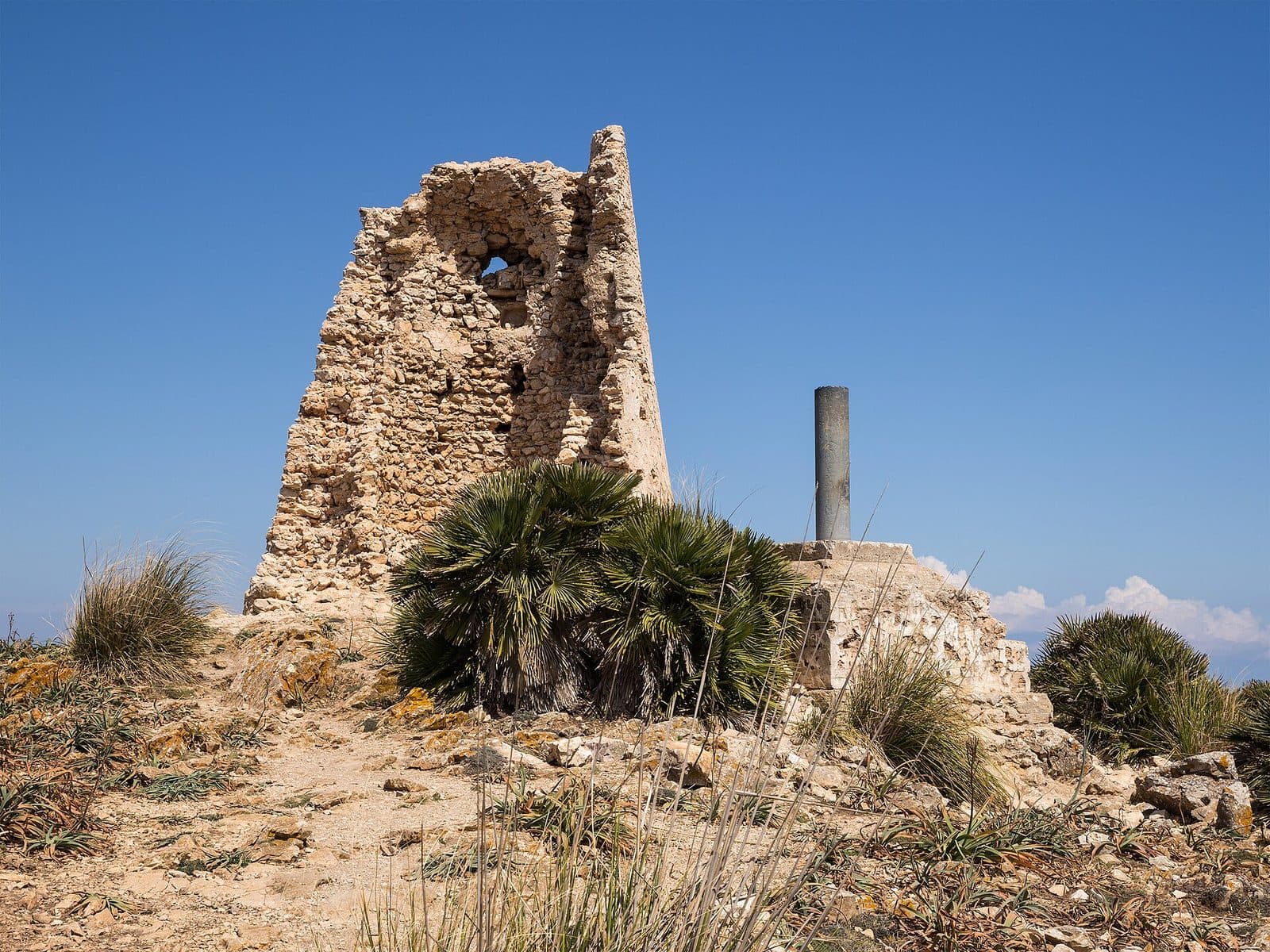

High above the coast of Capdepera, Talaia de Son Jaumell stands like a stone exclamation mark on the ridge. Only a ruin remains of the old watchtower. It is precisely this stark appearance that makes the place so impressive: weathered masonry in an open coastal landscape.
The tower is not a destination for a quick roadside stop. The visit begins below, at Cala Mesquida or Cala Agulla, and continues on foot along forest tracks, rocky paths, and steeper sections. Those who reach the top can see both bays, the coast of Capdepera, and the contours of northeastern Mallorca from a perspective that is difficult to imagine from the beach.
Talaia de Son Jaumell is particularly worthwhile for hikers who want to combine landscape and history. The ruin itself is modest in scale; the real experience comes from the ascent, the exposed location, and the sweeping views. By contrast, the terrain is less suitable for a casual stroll, very young children, or inexperienced hikers.
History and significance
Before Talaia de Son Jaumell became a silent ruin, its location served a highly practical purpose. Built in the 16th century, the tower served as a coastal watchtower. Its position on a prominent elevation made it possible to survey the stretch of coast around Cala Mesquida and Cala Agulla, as well as large parts of the Capdepera area.
The coastal watchtower
The historical significance of the structure is best understood from the summit. The tower did not stand there because the building site was convenient, but because the sea, bays, and coast could all be observed from this point. What makes the ascent demanding today—the height, rocky terrain, and distance from the nearest road—was a decisive advantage for an observation post. The tower's shape and its position on the narrow ridge still direct the eye outward today: toward the coastline, the bays, and the mountainous landscape of northeastern Mallorca.
From lookout post to ruin
Crumbling stonework marks the former structure, while wind and weather pass unhindered through the open sections. As a result, Talaia de Son Jaumell feels less like a self-contained monument and more like part of the summit itself.
The ruined condition makes the original choice of location especially easy to understand. Among the remains of the walls, it becomes clear just how isolated and exposed the post once was. The view that is now the goal of the hike was once fundamental to its purpose. The significance of Talaia de Son Jaumell is therefore revealed through the terrain and sightlines surrounding the tower.
What to see
Shortly before the destination, the ruin appears at the end of the ridge. It does not rise as an intact tower but as an irregular remnant of pale, weathered stone. The wind is often noticeably stronger here than on the sheltered sections of the ascent. The ground falls away around the masonry, and the view opens almost without transition across the sea, bays, and coastal mountains.
The cone-shaped tower ruin
The former watchtower had a cone-shaped form. Parts of the massive masonry survive, and its curve can still be discerned. Talaia de Son Jaumell is explicitly a ruin.
Up close, the masonry appears rough and elemental. Some sections stand higher, while others have deteriorated into low stone remains. Because the structure appears open and unsecured, caution is more important than searching for a supposedly designated sightseeing route. The stones are part of a historic structure, not steps or climbing equipment.
The pared-back form has an appeal of its own because almost nothing distracts from the interplay between architecture and location. The tower occupies the most prominent point on the ridge; its rounded, compact silhouette remains clearly recognizable both on the approach and when looking back during the descent.
The summit location
The ruin stands on a ridge, and its direct relationship with the nearby coast heightens the impression. A considerable amount of elevation is gained over the relatively short distance between beach level and the summit. Some sections therefore feel steep, especially where the ground is loose.
The old wall remains and rocky surroundings form the viewpoint. For this reason, the view should not be sought only from the tower itself. The exposed setting shapes the visitor experience more strongly than any architectural detail. Even on a calm day, there can be a powerful breeze along the ridge; in stronger winds, the open terrain requires additional caution.
The view of Cala Mesquida
Cala Mesquida can be seen particularly clearly from the summit. The beach, bay, and terrain behind it lie far below, while the coastline continues toward the northeast. From up here, it becomes apparent how the resort lies between the sea, dune landscape, and rising terrain.
Those who have climbed from Cala Mesquida can retrace at least part of their route through the landscape. The apparent proximity to the beach does not change the nature of the trail: the elevation gain and rocky sections turn this detour into a genuine hike.
The view of Cala Agulla and Capdepera
On the other side, the view opens toward Cala Agulla and across the coast of Capdepera. Forests, rocky ridges, and the blue sea alternate across the landscape. This juxtaposition of the two bays is one of the strongest reasons to make the climb: below, each bay is experienced separately, while from above both can be placed within the course of the coastal landscape.
In clear conditions, the impression extends far beyond the tower's immediate surroundings. Nevertheless, it is worth looking at more than the distant view. The vegetation on the ridge, the stony ground, and the isolated position of the ruin reveal as much about this place as the panorama does.
Visiting Talaia de Son Jaumell
The visit begins with a decision: should the tower be reached from Cala Mesquida, from Cala Agulla, or as part of a route connecting the two bays? Every option makes Talaia de Son Jaumell a hiking destination. There is no direct access by car to the ruin.
Ascent via Coll de Marina
One documented route begins at Camí del Coll de Marina and climbs from there to Talaia de Son Jaumell. This one-way route to the tower takes 50 minutes. This time does not describe the full outing, including the return journey, breaks, and time at the summit. Considerably more time should therefore be reserved for the visit, especially if you want to take photographs and enjoy the view at the ruin without rushing.
At first, the route is relatively easy to follow. Farther on, the wider sections give way to a narrower mountain trail. The climb is short but demanding and gains elevation quickly. On the final section, low vegetation, rock, and open terrain accompany the path to the tower.
Ascent from Cala Mesquida
From Cala Mesquida, the approach initially leads through the coastal landscape and toward the ridge. Red and blue dots along the paths can help with orientation, but the markings are faint in places. An up-to-date hiking map or saved route is therefore useful, even if the ruin is occasionally visible from the beach.
The direct ascent from the left side of Cala Mesquida is considered particularly demanding. Steep, rocky sections and loose scree require fitness, sure-footedness, and concentration. The fact that the tower looks close should not tempt hikers to underestimate the difficulty or the return journey.
Ascent from Cala Agulla
Cala Agulla can also serve as a starting point. The approach from this side is described as the more moderate alternative to the particularly steep direct route from Cala Mesquida. Nevertheless, it remains a mountain hike over stony ground. Sturdy footwear and a reasonable level of basic fitness are also required here.
A longer circular hike can connect Cala Agulla, Talaia de Son Jaumell, and Cala Mesquida. Its appeal lies in the variety: forest, coastal paths, summit, and two bays all feature in one tour. However, a circuit of this kind is very different from a short ascent to the ruin and should be prepared accordingly.
Time at the tower
There is no prescribed route around the destination. The ruin alone does not require much sightseeing time; the view and the break after the climb determine the length of the stay. An early start is particularly advisable in warm weather, as heat noticeably increases the strain. At the same time, the summit can be very windy. Before setting out, it is therefore worth checking not only the temperature but also the wind conditions.
Current access conditions should be checked before the hike. No reliable fixed opening hours or admission details are available.
Getting there and parking
The road journey ends in Cala Mesquida; only there does the approach on foot begin. Navigation directions to the town should therefore not be confused with arrival at Talaia de Son Jaumell. Between the resort and the ruin lie a hiking trail, considerable elevation gain, and, depending on the chosen route, steep mountain paths.
From Palma Airport
From Palma Airport, the road route follows the Ma-15, then the Ma-4030 and Ma-4040 to Cala Mesquida. The 82-kilometer road journey takes around 75 minutes. This information expressly covers only the journey to the town and does not include the ascent to the ruin.
The Ma-15 accounts for the longest part of the drive through the island's interior. In the northeast, the remaining roads lead through the Capdepera area to Cala Mesquida. When planning the hike, it makes sense to regard arrival not as the beginning of a short sightseeing stop but as the starting point for a separate walk.
From central Palma
From central Palma, Cala Mesquida is 85 kilometers away by road. The journey takes around 82 minutes and likewise follows the Ma-15, Ma-4030, and Ma-4040. Here too, the measured driving time ends in the coastal town, not at the tower above it.
Anyone traveling from Palma should calculate the outward and return drives, hiking time, and sufficient reserves for breaks together. Talaia de Son Jaumell is not suitable for a tightly scheduled stop on a driving tour because the walk forms the essential part of the visit.
The final section on foot
From Cala Mesquida, the path leads into the landscape behind or beside the bay. Alternatively, the hike begins at Cala Agulla and approaches Talaia de Son Jaumell from the other side. No bus stop has been recorded in the immediate vicinity of the attraction. Even when traveling to the region by other means, the ascent remains a walk through uneven terrain. For orientation on the final section, a hiking route is more helpful than standard road navigation that only recognizes Cala Mesquida as the destination.
Bus lines to Talaia de Son Jaumell at a glance
| Line | Route | Departures/day | First | Last |
|---|---|---|---|---|
| 422 | Cala Mesquida - Cala Rajada | 27 | 08:45 | 21:45 |
From the official GTFS feeds (TIB/SFM), no real-time data. The figures cover all stops in the town; weekend and holiday services differ — check with the operator before travelling.
Getting there by bus
Cala Mesquida (14018) · 2.0 km as the crow flies
- 422Cala Mesquida - Cala Rajada · Daily
Timetable data: official GTFS feeds (TIB/EMT), no real-time — check with the operator before travelling.
Nearby places
After the descent, the sea seems closer than before. From Talaia de Son Jaumell, the bays formed part of a broad coastal panorama; below, the beach, pines, and rocky shores once again become distinct landscapes. It is precisely this contrast that makes combining the hike with time at one of the two bays so appealing.
Cala Mesquida
Cala Mesquida is the most obvious starting point and also the place that provides the tower with its scenic setting on this side. The bay is known for its sandy beach and the dune landscape behind it. Wooden walkways cross sensitive areas and guide access before the hiking trails continue toward the surrounding ridges.
Combining the ascent with time at the beach is an obvious choice, but it should not lead to an overly casual assessment of the tour. Water shoes are no substitute for hiking boots on the rocky path. Those who want to go to the water after the descent are better off carrying their beach gear separately rather than completing the entire mountain route in unsuitable footwear.
Cala Agulla
Cala Agulla lies on the other side of the ridge and is a second classic starting point. From there, the route to Talaia de Son Jaumell initially passes through a more heavily wooded coastal landscape. On a circular tour, the bay can be connected with Cala Mesquida, with the tower forming the prominent high point between the two sections of coast.
This option reveals more of the surrounding area but also requires more planning than a straightforward out-and-back route. It is particularly important to decide how you will return to the starting point and whether your fitness, the weather, and the remaining daylight are suitable for the entire circuit.
Capdepera and Cala Ratjada
The coast around Capdepera and Cala Ratjada can easily be combined with the visit if a full day is planned for northeastern Mallorca. Both places lie in the same part of the island and provide opportunities to spend time in town or along the coast after the hike. Talaia de Son Jaumell itself should be visited first, while energy levels and weather conditions remain favorable for the ascent.
Those wishing to hike farther along the coast of Artà will find additional bays and coastal paths. However, such extensions turn the tower visit into a considerably longer undertaking. They require preparation and should not be started spontaneously simply because additional stretches of coast appear temptingly close from the summit.
The place it belongs to
Cala Mesquida in the place guidePractical visitor information
The first view from the beach can be deceptive: the tower seems within reach, but sections of the path are steep, rocky, and covered with loose scree. The most important preparation is therefore not a lengthy equipment list but an honest assessment of fitness, sure-footedness, and the weather.
Footwear and navigation
Sturdy hiking or trekking shoes with grippy soles are strongly recommended for the ascent. Smooth casual shoes and sandals provide too little grip on rock and scree. Long trousers can be comfortable where the narrow path passes low vegetation.
The red and blue trail markers are not equally clear everywhere. A saved route or up-to-date hiking map provides additional security. This is especially true at junctions and on the return journey, when the ruin is no longer visible ahead as an orientation point.
Sun, water, and wind
Water, sun protection, and headwear belong in your backpack. In warm weather, the steep ascent quickly becomes strenuous. Food for a break at the summit is also advisable.
At the same time, the wind should not be underestimated. Talaia de Son Jaumell stands in an exposed location, and conditions at the tower are often considerably breezier than down by the bay or in sheltered forest sections. Loose items should be securely stored. In problematic wind conditions, the open summit area is not a good place for risky photography positions.
Visiting with children
The tour is not recommended for young children. Steep sections, rocks, and scree require independent sure-footedness; a stroller is not an option for the ascent. For older children with mountain experience, suitability depends on the chosen route, fitness, and current conditions.
The route upward is not the only important factor. After the summit break comes the descent over the same uneven ground, where loose stones require additional attention. Families should therefore allow sufficient energy reserves and choose the more moderate route or avoid the ascent if there is any uncertainty.
The ruin
At Talaia de Son Jaumell, the exposed remains of the watchtower stand in the open landscape. This also means that responsibility and consideration rest with visitors. Rubbish belongs back in your backpack, and vegetation away from the path should be protected. Those who set out with these expectations will experience the ruin as what makes it distinctive: a remote historic lookout post in a rugged coastal landscape.
Local insider tips
Choose the more moderate route
The particularly direct ascent from the left side of Cala Mesquida is steeper and more demanding. Less experienced hikers are better off choosing the broader approach from Cala Agulla or via Coll de Marina.
Do not overestimate the trail markers
Red and blue dots help with orientation but are only faintly visible in places. A hiking route saved in advance is particularly useful during the descent and more helpful than standard road navigation.
Allow for wind at the summit
The wind at the exposed tower is often much stronger than down by the bays. Before the ascent, it is worth checking the wind conditions as well as the temperature.
Compare both bays
At the summit, do not stop after viewing Cala Mesquida: moving safely around the ruin also opens the view toward Cala Agulla and helps explain the strategic location of the old watchtower.
Keep hiking and beach gear separate
Anyone wishing to swim after the descent should carry beach gear separately. Sturdy hiking shoes remain the right choice for the rocky ascent; water shoes are unsuitable on rock and scree.