
Creu de sa Porta des Camp – Palma's Historic Boundary Cross
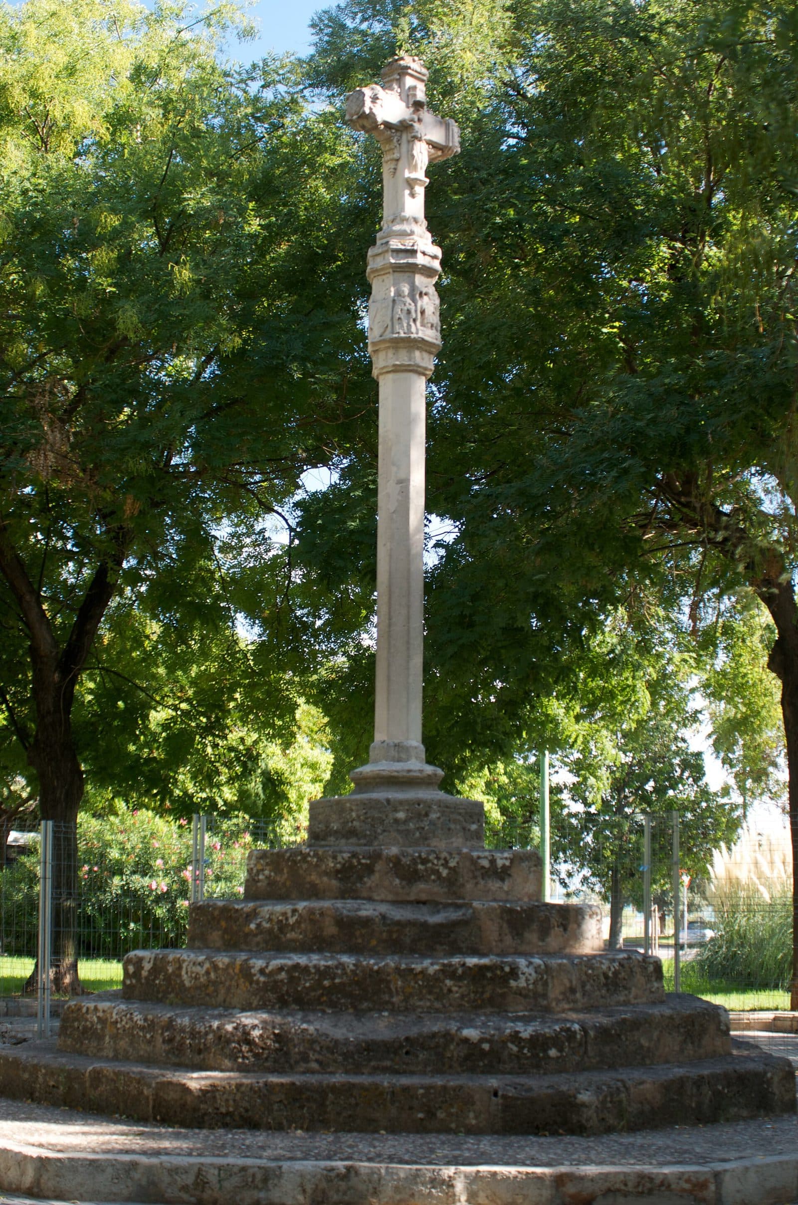

On the eastern edge of the Old Town, the Creu de sa Porta des Camp tells of a time when Palma did not gradually merge into suburbs but ended at walls, a moat, and a gate. The stone cross stood at an important crossing point: beyond the Porta del Camp lay the open countryside, while the fortified city stood before it. Anyone arriving or departing here crossed not only a territorial but also a symbolic threshold.
Today, the monument initially appears modest. It is not a museum, an extensive complex of ruins, or a structure requiring a long tour. That is precisely where its appeal lies. The cross can be read like a historical footnote in the cityscape—small in scale but closely linked to Palma's medieval boundary system, Christian imagery, and later urban expansion.
The Creu is particularly interesting for visitors who explore Palma on foot and have an eye for detail. Between the sa Calatrava district, the Porta del Camp, and the Baluard del Príncep, it becomes clear how the historic city fortifications shaped today's urban space, including its squares, street layouts, and changes in elevation. The cross provides a tangible point of reference.
Its status as a monument is also confirmed by its protection as a Bien de Interés Cultural. A visit is therefore worthwhile less as an isolated must-see than as a deliberately chosen stop on a walk along the eastern edge of the Old Town.
History and Significance
Before Palma expanded beyond its walls, a city gate formed a clear dividing line. The Porta del Camp provided access on the southeastern side of the fortified city; its name refers to the fields or open countryside outside the walls. The Creu de sa Porta des Camp belonged to this transitional space. It marked the boundary while giving both arrival and departure a religious meaning.
The Tradition of the Creus de Terme
The tradition of stone boundary crosses, known as creus de terme, spread across Mallorca from the Middle Ages onward. Such crosses stood at municipal boundaries, important routes, intersections, or city entrances. They served simultaneously as waymarkers, territorial markers, and Christian symbols. Travelers could recognize from them that they were entering or leaving a legally and socially defined area.
The Mallorcan tradition is associated with the Christian reorganization of the island following its conquest by King Jaume I. of Aragón in 1229. Boundary crosses have been documented on Mallorca since the 14th century. However, this does not mean that every surviving example has remained unchanged since that early period. For the Creu de sa Porta des Camp, what matters most is its place within this form of boundary marking maintained over centuries.
Its religious function was not merely decorative. A cross at a city exit could symbolize protection and blessing for the journey ahead; in the opposite direction, it marked the return to the city's Christian-influenced space. Orientation, devotion, and public order were thus combined in a single object.
Porta del Camp as a City Threshold
The cross's name only becomes clear through the Porta del Camp. The gate formed part of the fortified landscape that separated Palma from its surroundings. The wall included a moat crossed by a bridge at the gate. The Creu therefore did not stand just anywhere beside the road but in an area that everyone had to pass through when arriving at or leaving the city on this side.
Today, the historic crossing can only be read in fragments. The city walls were demolished by 1902, the moat was filled in, and the Plaça de la Porta del Camp was laid out above it. During later work on the Baluard del Príncep, arches from the old gate bridge reappeared. They serve as a reminder that today's square rests on a far more complex sequence of wall, moat, bridge, and gateway.
The distinction is important: the cross is not the Porta del Camp, nor is it the exposed bridge. It does, however, belong to the same historic setting. Together, these elements explain why a boundary marker made sense in this particular place.
From Boundary Marker to Cultural Monument
When the city walls disappeared, the Creu lost its original purpose. Palma no longer ended at this point, and urban expansion pushed the open countryside far outward. A functional marker on the city's edge became a historic object within the modern streetscape.
This transformation makes the cross especially revealing today. It shows how a monument can remain in place even though the meaning of its surroundings has changed completely. Where control, passage, and departure once shaped daily life, there is now an urban transition between the Old Town, Avenidas, and the coastal area. Its status as a Bien de Interés Cultural preserves the Creu as evidence of this older order.
What to See
The cross itself usually draws the first glance. Yet its impact is not conveyed by its silhouette alone. Base, shaft, and cross-shaped top form a vertical sequence that clearly sets the stone marker apart from the horizontal lines of the square and surrounding streets. Its location turns a comparatively small monument into a point of orientation.
Base and Shaft
The Creu stands on a solid stone substructure. This visibly anchors the monument in the ground and raises the cross itself above street level. Its design therefore follows the basic principle of Mallorcan boundary crosses: a sturdy base supports the slimmer shaft, with the religious image above it.
From close up, it is worth comparing the individual stone surfaces. Anyone taking photographs only from a distance will mainly notice the overall form; closer to the monument, its edges, transitions, and areas of relief become more prominent.
The Cross-Shaped Top
The meaning of the entire monument is concentrated in its upper section. The cross is not merely the end of the shaft but its symbolic center. Sources associate its design with the Gothic tradition and mention religious imagery, including references to the Passion of Christ and saints. Such depictions turned the boundary marker into a bearer of Christian remembrance.
Small reliefs are not always immediately legible outdoors. Viewing direction and light determine whether a figure stands out in three dimensions or disappears into the stone surface. It is therefore worth viewing the Creu from more than just the front. Even a slight change of position can reveal contours that appear flat from another perspective.
The iconography had a more immediate meaning for earlier viewers than it does for many passersby today. The cross evoked protection, the story of the Passion, and religious belonging. At the same time, its form was universally understandable: even without recognizing individual figures, the sign could be read as a Christian marker at the city entrance.
The Historic Location
In a sense, the most important “structural element” lies outside the stone: its location at the Porta del Camp. From here, the city's former boundary can be mentally reconstructed. Walled Palma stood on one side, while the land beyond the gates lay on the other. The Creu marked precisely this transition.
Large parts of the former fortifications are now gone, but the nearby Baluard del Príncep keeps the site's military dimension visible. The rediscovered arches of the former gate bridge add to the picture. They once crossed the moat surrounding the city wall. Only with this knowledge does it become clear that the cross belonged to an entire sequence of approach, crossing, and entry.
The square itself tells the story of later transformation. Once the wall and moat had lost their function, the moat was filled in and the area put to urban use. The Creu therefore no longer stands before a clearly defined edge of the landscape. It preserves the former boundary point in the middle of a city that has long since expanded far beyond it.
The Monument in the Cityscape
Photographically, the Creu draws its appeal from the contrast between historic stone and its present-day surroundings. A close-up shows the relief and surfaces, while a wider frame explains its location around the former gate. A perspective that includes both the cross and elements of the Old Town's edge or fortifications is particularly revealing.
The monument demands attention. Anyone looking for a monumental façade may pass by without grasping its significance. Those who instead examine its individual levels—first the base, then the shaft, followed by the top and finally the location—receive a small but unusually precise lesson in Palma's historic topography.
Visiting the Cross
A visit begins not with an entrance but with the right way of looking. The Creu de sa Porta des Camp stands as a monument in a public urban space. There is no sequence of rooms to work through and no exhibition prescribing a fixed order. It makes sense to begin by keeping some distance and taking in the overall form before examining the details in the stone.
Approaching the Cross
The best approach is from the direction of the Old Town or as part of a route along its eastern edge. This makes the location's original function easier to understand: the cross appears as a marker at a historic threshold rather than an isolated object placed there by chance.
Once there, a small change of perspective is recommended. From a distance, the silhouette stands out. Up close, the sculpted sections of the cross-shaped top become visible. It is then worth looking beyond the monument toward the former gateway and in the direction of the Baluard del Príncep.
The Creu is not a destination for a long standalone visit. How much time makes sense depends on whether you simply want a photograph or are also interested in the historical relationship between the gate, moat, and city fortifications. Anyone who incorporates the site into an Old Town walk will gain considerably more than from a brief stop by car.
Opening Hours and Admission
The available visitor information records neither fixed opening hours nor an admission price for the Creu de sa Porta des Camp. As accessibility and regulations in urban spaces can change, current information should be checked before visiting. Outdated times or prices from older travel guides are not a reliable basis for planning.
Regardless of this, the nature of the site remains the same: visitors view a historic outdoor monument, not the interior of a building. For planning purposes, the main consideration is therefore to allow enough time for the walk through the adjoining areas of the Old Town and not to approach the visit with the expectations of a museum.
Light and Perception
Relief-carved stone changes its appearance with the lighting. Light falling at an angle can define edges and figures more clearly, while even lighting can make the surface appear flatter. For photographs, it is therefore advisable to try several viewing directions on site rather than restricting yourself to a single frontal view.
The location forms part of everyday life in Palma. The monument is not separated from city life by an enclosed museum courtyard. This contrast is an essential part of the experience: a former boundary marker now stands within a mature, lively city. Anyone who pauses briefly can read several layers of urban history at once in this inconspicuous spot.
Getting There and Parking
From Palma Airport, the drive initially follows the Ma-19 toward Palma. The distance to Palma is 11 road kilometers, and the drive takes around 20 minutes. These details expressly apply to the route from the airport to Palma, not directly to the Creu de sa Porta des Camp. The final section follows the urban road network to the eastern edge of the Old Town.
By Car
Anyone arriving by car should not regard the cross as a destination where it is easy to stop briefly for a photograph. Palma's Old Town has numerous pedestrian areas, one-way streets, and access restrictions. Areas marked as ACIRE in particular may not be entered without authorization. An up-to-date navigation system and careful attention to signs are therefore more important than a supposedly direct route through the narrow streets.
It is more practical to leave the vehicle outside the narrow Old Town streets and complete the final section on foot. The Parc de la Mar parking garage serves as a starting point for the southern Old Town and attractions such as the cathedral, Almudaina, and Arab Baths. From there, the Creu can be included in a longer walk through the eastern Old Town. The specific parking situation and access arrangements should be checked on the day of the visit.
By Bus and on Foot
Several stops in this part of the city bear the name Porta des Camp. This makes it easy to combine the visit with public transportation followed by a short walk. As routes and timetables can change, it is advisable to check current connections before departure.
The site's historic logic is easiest to recognize on foot. Approaching from the Old Town, you reach the place where the gate, bridge, and moat once defined the transition to the surrounding countryside. From the coast or Avenidas, by contrast, the Creu appears as the first historic marker at the edge of the old city center. Both approaches tell the story of the same place from opposite perspectives.
Bus lines to Creu de sa Porta des Camp at a glance
| Line | Route | Departures/day | First | Last |
|---|---|---|---|---|
| 501 | Manacor - Campos - Palma | 208 | 05:38 | 23:58 |
| 504 | Tolleric - Palma | 109 | 06:13 | 23:13 |
| 501e | Campos - Palma, exprés | 59 | 06:50 | 20:50 |
| 515e | Cala d'Or - Palma | 10 | 10:30 | 19:15 |
| 22 | Plaça d'Espanya - Piscines de Son Hugo | 6 | 07:56 | 08:38 |
| N1 | Portopí - Porta des Camp | 4 | 00:55 | 23:55 |
| 19 | UIB i Parc Bit - Porta des Camp | 2 | 08:38 | 10:39 |
| 25 | s'Arenal - Pl. Reina | Catedral | 2 | 10:38 | 10:44 |
| CC | Circular Centre Ciutat | 2 | 06:50 | 08:00 |
| 512 | Portocolom - Felanitx | 1 | 08:05 | 08:05 |
From the official GTFS feeds (TIB/SFM), no real-time data. The figures cover all stops in the town; weekend and holiday services differ — check with the operator before travelling.
Getting there by bus
Porta des Camp 2 (40002) · 0.0 km as the crow flies
- 501Manacor - Campos - Palma · Daily
- 501eCampos - Palma, exprés · Mon-Sat
- 504Tolleric - Palma · Daily
- 515eCala d'Or - Palma · Mon-Fri
458-Porta des Camp · 0.0 km as the crow flies
- 23s'Arenal / Parc Aquàtic - Pl. Espanya · 06:27–21:50 · Daily
- 25s'Arenal - Pl. Reina | Catedral · 06:36–21:01 · Daily
- 30Marivent-Palau de Congressos · 08:00–08:00 · Daily
- 31Sant Jordi - Sindicat · 08:00–08:00 · Daily
- 35Aquàrium - Pl. Reina | Catedral · 06:21–22:41 · Daily
- A1Aeroport - Palma Centre · 08:00–08:00 · Daily
- N1Portopí - Porta des Camp · 08:00–08:00 · Daily
450-Porta des Camp · 0.1 km as the crow flies
- 19UIB i Parc Bit - Porta des Camp · 05:46–22:12 · Daily
- 23s'Arenal / Parc Aquàtic - Pl. Espanya · 06:27–21:50 · Daily
- 31Sant Jordi - Sindicat · 08:00–08:00 · Daily
- 35Aquàrium - Pl. Reina | Catedral · 06:21–22:41 · Daily
- A1Aeroport - Palma Centre · 08:00–08:00 · Daily
- N1Portopí - Porta des Camp · 08:00–08:00 · Daily
Porta des Camp 1 (40108) · 0.1 km as the crow flies
- 501Manacor - Campos - Palma · Daily
- 501eCampos - Palma, exprés · Mon-Sat
- 504Tolleric - Palma · Daily
- 512Portocolom - Felanitx · Daily
- 515eCala d'Or - Palma · Mon-Fri
969-Porta des Camp · 0.1 km as the crow flies
- 30Marivent-Palau de Congressos · 08:00–08:00 · Daily
451-Escola Graduada · 0.2 km as the crow flies
- 12Sa Garriga - Nou Llevant · 08:00–08:00 · Daily
- 24Antiga Presó - Nou Llevant · 06:33–21:18 · Daily
- 31Sant Jordi - Sindicat · 08:00–08:00 · Daily
- N1Portopí - Porta des Camp · 08:00–08:00 · Daily
457-Escola Graduada · 0.3 km as the crow flies
- 31Sant Jordi - Sindicat · 08:00–08:00 · Daily
- N1Portopí - Porta des Camp · 08:00–08:00 · Daily
412-Pérez Galdós · 0.3 km as the crow flies
- 12Sa Garriga - Nou Llevant · 08:00–08:00 · Daily
- 24Antiga Presó - Nou Llevant · 06:33–21:18 · Daily
983-Jutjats Nous · 0.4 km as the crow flies
- CCCircular Centre Ciutat · 08:00–08:00 · Daily
459-Joan Maragall · 0.5 km as the crow flies
- 30Marivent-Palau de Congressos · 08:00–08:00 · Daily
664-pl. de sa Quartera · 0.5 km as the crow flies
- CCCircular Centre Ciutat · 08:00–08:00 · Daily
452-Gabriel Alomar - Àrea d'intercanvi Sindicat · 0.5 km as the crow flies
- 12Sa Garriga - Nou Llevant · 08:00–08:00 · Daily
- 19UIB i Parc Bit - Porta des Camp · 05:46–22:12 · Daily
- 22Plaça d'Espanya - Piscines de Son Hugo · 06:49–21:14 · Daily
- 23s'Arenal / Parc Aquàtic - Pl. Espanya · 06:27–21:50 · Daily
- 24Antiga Presó - Nou Llevant · 06:33–21:18 · Daily
- 35Aquàrium - Pl. Reina | Catedral · 06:21–22:41 · Daily
- A1Aeroport - Palma Centre · 08:00–08:00 · Daily
- CCCircular Centre Ciutat · 08:00–08:00 · Daily
- N1Portopí - Porta des Camp · 08:00–08:00 · Daily
Timetable data: official GTFS feeds (TIB/EMT), no real-time — check with the operator before travelling.
Nearby Sights
The area around the Porta del Camp is a part of Palma where the boundary between historic monument and ordinary urban space is particularly fluid. The Creu can therefore be combined perfectly with a walk that does more than simply collect individual sights, instead tracing the former course of the fortifications.
Sa Calatrava
In this context, the Santa Fe church, El Temple, and the Arab Baths are suitable additional stops without reducing the Creu to a mere stopover.
The most meaningful common thread remains the city's development: from the boundary cross, across the former gate area, and into the Old Town. This explains the location of the Creu more vividly than an isolated journey there.
Baluard del Príncep
The nearby Baluard del Príncep makes the military side of the city boundary visible. While the cross expressed protection and belonging in religious terms, the bastion represented Palma's physical defenses. The arches of the old bridge at the Porta del Camp, which once crossed the city moat, were also exposed in this area.
Connecting the two sites is particularly revealing because they illustrate different functions of the same boundary. The bastion defended it, the bridge enabled controlled passage, the gate regulated entry, and the Creu gave the threshold religious and territorial meaning.
Southern Old Town and Parc de la Mar
From the Porta del Camp, the route continues toward the southern Old Town. There, the cathedral, Almudaina, and Parc de la Mar can be incorporated into a longer walk. However, these well-known sights should not distract from the smaller traces of history. The contrast between representative architecture and a boundary cross beside the road demonstrates the diversity of Palma's historic heritage.
Can Pere Antoni is also mentioned as a nearby beach. A visit to the Creu can therefore serve as a transition between a historical walk and a route beside the sea. The thematic focus remains clear: the cross explains the former outer boundary of a city whose modern urban area has long since extended far beyond it.
Local insider tips
Walk Around the Top
Do not stop at the first frontal view: the religious reliefs on the cross-shaped top appear more or less clearly depending on the viewing direction and light. A small change of position reveals more than zooming in heavily.
Read the Boundary as a Whole
The Creu gains meaning when viewed in relation to the Baluard del Príncep and the former gateway. The cross, city moat, bridge, and fortifications performed different roles at the same historic threshold.
Include the Surroundings
A close-up shows the stone but does not explain the location. It is also worth taking a wider photograph that shows the cross on the eastern edge of the Old Town and makes its original connection to the Porta del Camp visible.
Approach from the Old Town
Walking from sa Calatrava lets you experience the Creu in the historic direction of travel toward the former city exit. You can then continue along the Baluard del Príncep or toward Parc de la Mar.