
La Trapa near Sant Elm: Monastery Ruins and Nature Reserve
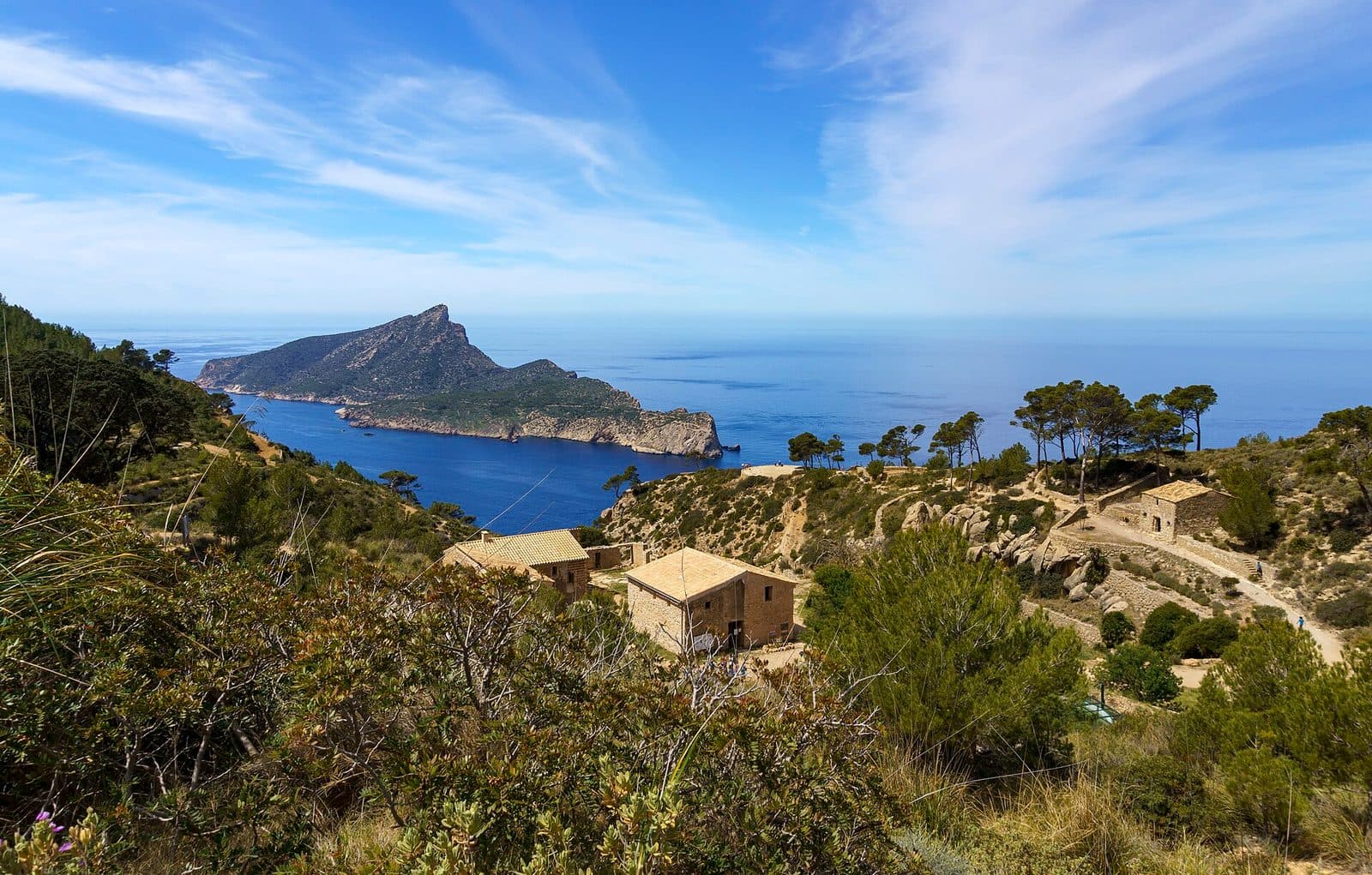

La Trapa begins not with an entrance gate, but with a path. From Sant Elm, the route leads out of the coastal village, climbs through the foothills of the Serra de Tramuntana, and eventually reaches a secluded valley above the sea. There, the remains of a Trappist monastery stand amid terraces, dry-stone walls, and rugged rock. Opposite, Sa Dragonera forms an elongated silhouette on the horizon.
This combination is precisely what makes the place special: La Trapa is neither a polished monastery complex nor merely a viewpoint. The nature reserve preserves a historic cultural landscape where it is still possible to see how people made a steep, dry coastal slope habitable and suitable for farming. The buildings, water supply, and terraces therefore belong together.
The excursion is aimed primarily at hikers, nature watchers, and visitors who prefer experiencing historic places within their landscape rather than behind museum doors. Anyone hoping simply to step out of the car for a quick visit has come to the wrong place. Those who appreciate rocky paths, quiet ruins, and sweeping views across the southwest coast will find one of the most impressive hiking destinations near Sant Elm.
History and significance
The history of La Trapa begins with an escape. In the aftermath of the French Revolution, Trappist monks from Normandy left their homeland and reached Mallorca. Around 1810, they settled in the remote Vall de Sant Josep. The valley lay far from larger settlements and offered the seclusion that suited their monastic life. However, this was not a comfortable location: The slope is steep, water is precious, and level ground for cultivation first had to be created.
The Trappists in Vall de Sant Josep
The monks built a monastery and organized daily life using local resources as far as possible. This included residential and farm buildings, a chapel, and facilities for supplying and working the land. To this day, the name La Trapa directly recalls the Trappists' formative presence in the landscape.
The choice of valley is best understood on site. Behind the buildings, the slopes rise; in front of them, the view opens toward the sea and Sa Dragonera. The seclusion was not a romantic backdrop, but both a requirement and a challenge: Every usable strip of soil had to be secured, and every flow of water had to be considered.
Water, soil, and dry stone
The work performed on the landscape proved particularly enduring. The monks created terraces and built walls using traditional dry-stone techniques. These walls require no mortar; their carefully placed stones retain soil on the slope and create areas that can be cultivated in the first place. Water collection and channeling systems with underground catchments were constructed to provide a water supply.
La Trapa therefore tells more than religious history. The site is also an example of the traditional skills of the Serra de Tramuntana: directing water, preventing soil from sliding away, and making a rocky slope usable with as little material as possible. What appears picturesque today was originally a precise response to difficult living conditions.
From abandoned monastery to protected area
After monastic use ended, the buildings fell into ruin, while walls and terraces remained as traces in the landscape. Today, the Mallorcan conservation organization GOB looks after La Trapa. The estate was purchased through a public fundraising campaign, closely linking its protection, care, and restoration with civic involvement.
A wildfire destroyed large parts of the estate's vegetation in 2013. Since then, the regeneration of the landscape has also become a visible part of the area's history. In 2022, the former monastery was granted protected heritage status. La Trapa is thus preserved simultaneously as a natural area, a historic ensemble, and evidence of traditional land use.
What to see
The first glance often goes to Sa Dragonera. Yet anyone who immediately turns back misses the true context of La Trapa. The ruins, terraces, and waterworks are not a random collection, but parts of a system through which the monks organized living, working, cultivation, and supplies in a secluded valley.
The monastery buildings
The old monastery buildings stand low among rock, vegetation, and walls. Their present ruined state requires some imagination. The surviving structures reveal not a single grand building, but rather the simple layout of a place intended for work and daily life.
Wall sections, openings, and preserved parts of buildings mark the heart of the former settlement. The architecture does not compete with the landscape, but follows traditional stone-building methods and remains closely connected to the terrain. Perspectives change quickly while walking around: From above, a building appears to be part of the terraces, while from the valley side it looks like a clearly defined human intervention in the slope.
The chapel remains
The remains of the chapel recall the settlement's religious purpose. They are among the most important structures for distinguishing La Trapa from an ordinary agricultural estate. However, no one should expect monumental church architecture. The surviving traces tell of a small, secluded community and a daily life in which prayer and physical labor existed side by side.
The chapel is therefore best understood in connection with the other buildings. Its value lies not in lavish decoration, but in its position within the ensemble. Among the living quarters, agricultural areas, and water system, it represents the religious purpose of the former settlement.
The terraces and dry-stone walls
The residents' achievement becomes especially clear in the terraces. Rows of stones run across the slope, supporting strips of soil and dividing the terrain into levels. From a distance, they appear almost self-evident; up close, the irregular stones, joints, and changes in elevation reveal how much manual labor was required to wrest usable land from the slope.
These dry-stone walls are not a decorative frame for the ruins. Without them, rain would have washed away the scarce soil more easily. The terraces retained earth and made cultivation possible. Anyone walking slowly through the site will therefore recognize a landscape shaped by labor, whose largest structures do not rise high but follow the contours of the mountain.
The water system
The adaptation to the location is even more apparent in the water supply. The Trappists created catchments and a system designed to collect water and make it usable before it disappeared into the permeable, sloping terrain. Water was not an incidental convenience here, but the foundation of the entire monastery's operation.
The surviving traces are less spectacular than the view, but they are among the most revealing details at La Trapa. Walls, terraces, and the water supply together form a technical response to dryness and gradient. Only this context explains why the site is also significant as ethnological heritage.
Mill and threshing floor
The agricultural ensemble also includes the mill and threshing floor. Both point to the processing of what was produced on the painstakingly created fields. The threshing floor forms part of the open landscape as a working area, while the mill is a reminder that La Trapa was not only a place of retreat but also a working farm.
Such elements are easily overlooked because they seem inconspicuous beside the monastery ruins. Yet they offer a sense of the site's daily rhythm: cultivating, harvesting, processing, securing water, and maintaining the buildings. The monastery functioned only because all these activities worked together.
The view of Sa Dragonera
At the viewpoint, the landscape opens toward the sea. Sa Dragonera lies long and jagged off the coast; its shape is often compared to a dragon resting or rising from the water. From La Trapa, this silhouette can be seen particularly clearly in its entirety. Depending on the vantage point, the rocky coast and the depth of the valley also enter the scene.
The view is more than a reward at the end of the climb, because it also explains the site's powerful effect. Behind the viewer lie ruins and terraces; ahead are the sea and the island. Human labor and a largely undeveloped coastal landscape thus stand directly beside each other. For photographs, it is worth aiming not only at Sa Dragonera, but also including a dry-stone wall or part of the monastery buildings in the foreground.
Visiting La Trapa
La Trapa is reached on foot. The approach itself is an essential part of the experience, as the transition from the streets of Sant Elm to the rocky mountains makes the former monastery's seclusion understandable. The usual route begins in the village, follows Avinguda de la Trapa, and continues into the countryside through the area around Camí de Can Tomeví.
Ascent from Sant Elm
Beyond Sant Elm, the surface alternates between tracks, woodland paths, and rocky trails. There are climbs, and some route variations pass through steeper or less clearly defined terrain. Signs to La Trapa and GR 221 markers help with navigation, but they are no substitute for an up-to-date hiking map. At junctions in particular, the chosen route should be clear before continuing.
On the outward route, the complex initially appears as a small group of buildings within a vast landscape. As the trail descends into Vall de Sant Josep, the terraces and ruins gradually come together. This approach is part of the site's dramatic effect: First comes the coastal landscape, then the view into the valley, and finally the historic complex itself.
Time for the ruins and view
Allow enough time at the site to explore more than just the viewpoint. The monastery buildings, chapel remains, mill, threshing floor, and water system lie in different parts of the ensemble. Anyone wishing to understand their connections should walk slowly and view the terraces from different elevations.
The total time depends greatly on the route. One described circular hike from Sant Elm covers 12 kilometers and takes about four hours; other variations may be shorter or more demanding. This time includes the hike. Longer breaks, nature watching, and a detailed exploration of La Trapa may require additional time.
Time of day and visitor numbers
An early start offers several advantages: It is easier to find a parking space in Sant Elm, while also leaving extra time in case the terrain requires more attention than expected.
At the viewpoint, it is worth not moving on immediately after taking the obligatory photograph. Since no reliable visiting hours or admission details are available, current information for the protected area should be checked before setting out.
Getting there and parking
The stated distances and driving times refer to the coastal village of Sant Elm. From there, the usual route to La Trapa continues on foot along hiking trails and tracks through mountainous terrain.
From Palma and the airport
Sant Elm is 37 kilometers by road from central Palma. The drive takes around 44 minutes and follows Ma-1, then Ma-1030. From Palma Airport, the road distance to Sant Elm is 47 kilometers; the drive via Ma-20, Ma-1, and Ma-1030 takes around 45 minutes.
Ma-1030 leads to Sant Elm on the final road section. Within the village, the usual hiking approach begins around Avinguda de la Trapa. From here onward, visitors should not expect the convenience of an attraction located directly beside a parking area: The trail climbs into the mountains and turns La Trapa into a hike lasting several hours.
Parking in Sant Elm
A larger parking area is located at the entrance to Sant Elm near Av. Jaume I. It is suitable as a starting point, although this means first walking through part of the village. It can fill up on busy days. Arriving early is therefore advisable, especially because beachgoers also use the same parking spaces.
Some visitors try to park closer to Avinguda de la Trapa. Spaces there are more limited, and local signs must be observed. A slightly longer approach from the village entrance is often the less stressful option than spending a long time searching for a free space in the narrower streets.
By public transport
Sant Elm can be reached by public transport, but no bus stop is listed in the immediate vicinity of La Trapa. The bus therefore replaces only the road journey to the starting point. The same requirements apply to the onward route as when arriving by car: sufficient time, suitable equipment, and a clearly chosen hiking route.
Nearby places
After dusty paths and rocky slopes, Sant Elm feels almost like the opposite of La Trapa. The small coastal village offers a beach, sea views, and places to eat and drink. The hike can therefore be combined easily with a break beside the water, without needing another major sightseeing program on the same day.
Sant Elm
Sant Elm is the natural starting point for the hike. Sa Dragonera is already visible from the village, but only from the heights near La Trapa does the island reveal its elongated shape off the open coast. This change in perspective makes the combination appealing: below, an inhabited coastal village; above, the secluded Vall de Sant Josep.
After returning, the beach and waterfront are ideal for a quiet break to end the day. Restaurants can be found in the village, while the parking area at the entrance is also close to the beach. Those who begin the hike early can spend the later part of the day in Sant Elm rather than overloading the outing with additional detours.
Sa Dragonera
Sa Dragonera dominates the view from La Trapa and gives the entire excursion its geographical orientation. However, the offshore island should be regarded as a separate destination. From La Trapa, visitors primarily experience its silhouette and its position off the southwest coast; exploring the island requires separate planning.
This is precisely why it makes sense to experience the view from above first. Terrace walls and monastery ruins form a historic foreground, while Sa Dragonera closes the horizon. Anyone who visits the island later will recognize its shape again from a completely different perspective.
Torre de Cala en Basset
Several circular hikes combine La Trapa with Torre de Cala en Basset and the coastal area around the bay of the same name. This combination is scenically appealing, but it lengthens the excursion and may include more demanding sections. It should not be regarded spontaneously as a small addition.
For hikers with sufficient fitness, it creates a longer circuit through the southwest of the Tramuntana. Families, people with a fear of heights, or less experienced hikers are usually better advised to return via the more predictable access route to La Trapa.
The place it belongs to
Sant Elm in the place guidePractical information for your visit
The character of La Trapa is easily underestimated because photographs usually show peaceful ruins and sweeping sea views. Between them, however, lie rocky paths, gradients, and, depending on the chosen route, sections that can be difficult to follow. A visit therefore requires the preparation of a hike rather than that of an ordinary attraction.
Footwear and navigation
Sturdy shoes with good grip are advisable for the changing terrain. On loose stones and during the descent, sure footing matters more than speed. Anyone choosing a circular route should note that some variations follow narrower paths and may include a short rocky section at Pas de sa Trapa.
An up-to-date map or a reliably saved route should be part of your equipment. Signposts and markers are helpful, but not every junction is equally clear from every direction. In uncertain weather, with inadequate fitness, or when in doubt about the route, returning along the familiar outward path is the more sensible decision.
Sun, water, and the protected area
The landscape is dry and partly exposed. Water and sun protection should therefore be packed in Sant Elm. Setting out early helps avoid the busiest periods and prevents the climb from beginning unnecessarily late.
La Trapa is a nature reserve, not an unrestricted adventure playground. Paths, information boards, and barriers should be respected, all waste should be carried out, and historic walls should not be climbed. Dry-stone walls in particular can suffer lasting damage when even individual stones are dislodged.
With children
For children with hiking experience, La Trapa can be an exciting destination because the ruins, traces of water systems, and dragon shape of Sa Dragonera offer tangible discoveries. The key factors are stamina, sure footing, and a route suited to the family's experience. The complete circuit is not automatically the best choice.
Families are advised to return after the visit via the access track or the more predictable path rather than adding more demanding circular-route sections. Sufficient breaks and reserves for the return journey are more important than reaching every viewpoint.
What not to expect
La Trapa is a nature reserve with ruins and historic structures in a protected landscape. The surviving monastery buildings, chapel remains, and other features together form the historic ensemble. The viewpoint alone also tells only half the story: Anyone who notices the terraces, water channels, mill, and threshing floor will understand why La Trapa matters beyond its beautiful panorama. The strongest impression comes not from a single building, but from the interplay of monastic remains, the cultivated slope, and the open coast.